lovethailand home >North Travel Attractions >Nan Travel Attractions >Pua >Phu Kha > Doi Phu Kha National Park
TL;DR: Doi Phu Kha National Park is located at Phu Kha Subdistrict, Pua District, Nan Province, Thailand, open Daily, hours Open according to national park operating hours.

Doi Phu Kha National Park

Open Days: Daily
Opening Hours: Open according to national park operating hours
Doi Phu Kha National Park in Nan Province is one of northern Thailand’s most important mountain national parks, covering approximately 1,065,000 rai or 1,704 square kilometers. The park extends across 8 districts of Nan Province: Chaloem Phra Kiat, Tha Wang Pha, Pua, Chiang Klang, Thung Chang, Bo Kluea, Santi Suk, and Mae Charim. It is famous for rare plants, high mountain forests, watershed ecosystems, Doi Phu Wae trekking, Phu Kha viewpoint 1715, waterfalls, caves, birdwatching, rafting on the Wa River, and the legendary Chomphu Phu Kha tree.
Doi Phu Kha National Park received the Thailand Tourism Award in 2008 as an outstanding natural attraction in northern Thailand. Its landscape contains 6 major forest types: hill evergreen forest, dry evergreen forest, mixed deciduous forest, dry dipterocarp forest, natural pine forest, and grassland. This ecological diversity makes the park one of the most valuable conservation areas in Nan Province.
The most iconic plant of the park is Chomphu Phu Kha, a rare and endangered tree found in Thailand only within Doi Phu Kha National Park. The tree can grow up to around 25 meters tall and produces long pink flower clusters from January to early March. February is the most popular period for visitors who want to see the blossoms. The easiest viewing point is beside the road, about 5 kilometers from the park headquarters.
Other rare and endemic plants in the park include the giant fishtail palm, known as tao rang yak, which can reach around 40 meters in height, and kwam phu kha, a rare maple-related tree with reddish young leaves and green mature leaves. These plants make the park an important destination for botanical study and nature education.
The park is also a habitat for rare birds such as red-faced liocichla, scarlet minivet, and Indian grass warbler. Its highland forests provide excellent conditions for birdwatching, butterfly observation, and ecological learning, especially along the park’s nature trails.
The Doi Phu Kha mountain range is part of a complex highland system connected to the far end of the Himalayan range. Phu Kha Peak is the highest mountain in Nan Province, rising approximately 1,980 meters above sea level. The park is also the source of important rivers and streams, including the Nan River, Pua River, and Wa River.
The geological story of Doi Phu Kha is equally fascinating. The area was once under the sea before tectonic movement lifted the land into mountains. Underground seawater later evaporated and left salt deposits, which are connected to the salt wells found in Bo Kluea District. Fossil evidence from Doi Phu Wae includes ancient marine shell remains dating back around 195–205 million years to the late Triassic period.
The Chomphu Phu Kha Nature Trail allows visitors to explore the park’s rare plants and highland forest. There are 2 main trail options: a larger loop of about 4 kilometers taking around 3 hours, and a shorter loop of about 2 kilometers taking around 1.5 hours. Along the route, visitors can see rare plants, endemic species, medicinal plants, and rich hill evergreen forest.
Another important nature route is the ancient forest trail at Doi Dong Ya Wai, which is about 7 kilometers long and takes around 5 hours to walk. This trail is known for birdwatching, butterflies, and old forest ecosystems. It is suitable for serious nature lovers, birdwatchers, and hikers who want a deeper experience of Doi Phu Kha’s forest environment.
Doi Phu Wae is one of the most outstanding trekking destinations in the park. It rises approximately 1,837 meters above sea level and features open highland grassland, stone terraces, steep cliffs, and rare plants such as kho palms and rhododendrons. To reach Doi Phu Wae, travelers drive about 63 kilometers from the park headquarters to Phu Kha Ranger Station 9 at Ban Dan, then hike about 6–8 kilometers to the summit. Porter services are available during the trekking season.
Sila Phet Waterfall is located at Ban Pa Tong in Sila Phet Subdistrict. The waterfall cascades over several tiers of rock and is suitable for swimming and relaxing. The area is also known for colorful butterflies. From Nan town, visitors travel along Highway 1080 toward Pua, turn onto Route 1170 near kilometer markers 41–42, continue about 10 kilometers, and walk a short distance to the waterfall.
Pha Daeng Cave at Ban Mani Phruek in Ngop Subdistrict is the longest cave in Doi Phu Kha National Park. Inside are stalactites, stalagmites, waterfalls, and a large stream. In the past, the cave served as a hideout base for the Communist Party of Thailand. Today, remains of shelters, beds, medical beds, hidden weapon pits, food trays, and other objects can still be seen. Reaching the cave requires about 3 hours of trekking through hills, forest, and Hmong communities in the valley.
Pha Khong Cave has a small entrance but contains chambers with stalactites, stalagmites, and flowing water. The cave floor is clayey and slippery, and visitors should avoid entering during the rainy season because flooding may occur inside. It is located about 7 kilometers from the park headquarters, followed by another 2 kilometers on foot. Visitors should contact park officers for guidance.
Ton Tong Waterfall is a medium-sized limestone waterfall about 3 kilometers from the park area. It has 3 levels and is approximately 60 meters high. The route passes Ban Toei junction, then continues about 800 meters by vehicle and another 200 meters on foot. The waterfall’s rocky gorge is covered with mosses, ferns, and moist green vegetation.
Phu Fa Waterfall is the tallest waterfall in Doi Phu Kha National Park, about 140 meters high with 12 tiers. A trip to the waterfall usually requires 2 days for the round journey and sightseeing. Visitors should contact park officers and prepare carefully because the route is suitable for experienced hikers.
Tad Luang Waterfall is about 1 kilometer from Ban Thung Hao in Pua District. It has beautiful pools suitable for swimming and is also a conservation area for local phluang fish. The waterfall is suitable for families and visitors looking for a more accessible nature experience.
Rafting on the Middle Wa River is one of the park’s most exciting adventure activities. The route includes more than 20 rapids, generally rated around levels 3–5. Visitors should join experienced operators and check water levels before traveling.
Another popular stop is Viewpoint 1715 on the Pua–Bo Kluea road. It offers wide mountain views and is one of Nan’s best-known scenic stops. The route also connects travelers to Bo Kluea, Sapan Village, and other mountain destinations in northern Nan.
Getting There from Nan town, take Highway 1080 toward Pua District, then continue on the Pua–Bo Kluea mountain road to Doi Phu Kha National Park headquarters. The road is scenic but winding, so visitors should check their vehicle, drive carefully, and avoid speeding, especially during rain or heavy fog.
| Name | Doi Phu Kha National Park |
| Location | Phu Kha Subdistrict, Pua District, Nan Province, Thailand |
| Coordinates | 19.1740, 101.0800 |
| Highlights | Chomphu Phu Kha, Viewpoint 1715, Doi Phu Wae, Phu Fa Waterfall, Sila Phet Waterfall, Pha Daeng Cave, and Wa River rafting |
| Area Size | Approximately 1,065,000 rai or 1,704 square kilometers |
| Distinctive Features | Hill evergreen forest, dry evergreen forest, mixed deciduous forest, dry dipterocarp forest, natural pine forest, grassland, and rare endemic plants |
| Travel Information | From Nan town, take Highway 1080 to Pua District, then continue on the Pua–Bo Kluea road to the park headquarters |
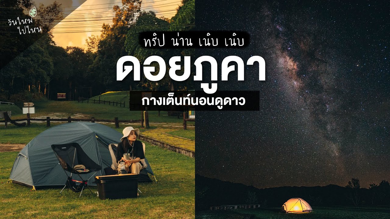
| Current Status | Open as a national park, nature destination, nature trail area, and overnight camping site |
| Open Days | Daily |
| Opening Hours | Open according to national park operating hours |
| Fees | Thai Adults 40 Baht, Thai Children 20 Baht / Foreign Adults 200 Baht, Foreign Children 100 Baht |
| Facilities | Visitor center, park accommodation, camping ground, restrooms, viewpoints, and nature trails |
| Main Areas / Zones | Chomphu Phu Kha, Viewpoint 1715, Doi Phu Wae, Sila Phet Waterfall, Pha Daeng Cave, Pha Khong Cave, Ton Tong Waterfall, Phu Fa Waterfall, Tad Luang Waterfall, and Wa River rafting route |
| Caretaker | Department of National Parks, Wildlife and Plant Conservation |
| Main Contact Number | 082-194-1349, 054-731-623 |
| Official Website / Official Page | Doi Phu Kha National Park Official Facebook Page |
| Nearby Tourist Attractions | 1. Viewpoint 1715, about 5 km 2. Chomphu Phu Kha Viewing Point, about 5 km 3. Ton Tong Waterfall, about 3 km 4. Bo Kluea Rock Salt Wells, about 35 km 5. Sapan Village, about 45 km |
| Nearby Restaurants | 1. Doi Phu Kha National Park Welfare Shop, about 0 km 2. Phu Kha Local Restaurant, about 5 km 3. Bo Kluea View Restaurant, about 35 km 4. Yud Wela Cafe Sapan, about 45 km 5. Sapan Village Cafe, about 45 km |
| Nearby Accommodations | 1. Doi Phu Kha National Park Accommodation, about 0 km, Tel. 082-194-1349 2. Doi Phu Kha National Park Camping Ground, about 0 km, Tel. 082-194-1349 3. Doi Phu Kha Resort, about 10 km 4. Bo Kluea View Resort, about 35 km, Tel. 081-530-3433 5. Sapan See View, about 45 km, Tel. 081-882-9554 |
Frequently Asked Questions (FAQ)
Q: Where is Doi Phu Kha National Park located?
A: Doi Phu Kha National Park is located in Nan Province, with the main park headquarters in Phu Kha Subdistrict, Pua District, and the park area extending across several districts.
Q: When do Chomphu Phu Kha flowers bloom?
A: Chomphu Phu Kha usually blooms from January to early March, with February being the most popular month for visitors.
Q: What is the entrance fee for Doi Phu Kha National Park?
A: Thai adults pay 40 Baht and Thai children pay 20 Baht. Foreign adults pay 200 Baht and foreign children pay 100 Baht.
Q: Does Doi Phu Wae require trekking?
A: Yes. Visitors must hike around 6–8 kilometers from the Ban Dan ranger station area to reach the summit, and advance contact with park officers is recommended.
Q: What activities are suitable in Doi Phu Kha National Park?
A: The park is suitable for mountain viewpoints, trekking, birdwatching, rare plant viewing, waterfalls, caves, camping, and Wa River rafting.
Q: How do visitors travel from Nan town to Doi Phu Kha National Park?
A: Travel from Nan town on Highway 1080 to Pua District, then continue on the Pua–Bo Kluea mountain road to the park headquarters.
Tel : 025620760
Mobile : 054626770
![]() Category: ●Nature and Wildlife
Category: ●Nature and Wildlife
![]() Group: ●National Parks and Marine Reserves
Group: ●National Parks and Marine Reserves
Last Update : 3 MonthAgo
Doi Phu Kha National Park Map
Recommend


