
lovethailand home >Northeastern Travel Attractions >Nakhon Ratchasima Travel Attractions >Soeng Sang >Soeng Sang > Nong Lak Sila Community Forest
TL;DR: Nong Lak Sila Community Forest is located at Soeng Sang Subdistrict, Soeng Sang District, Nakhon Ratchasima Province 30330, open Daily, hours 06.00 – 18.00.
Nong Lak Sila Community Forest
Open Days: Daily
Opening Hours: 06.00 – 18.00
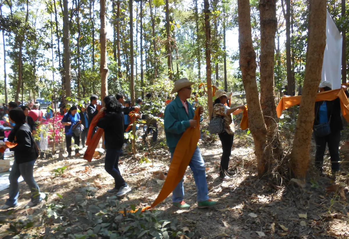
Nong Lak Sila Community Forest is located in Soeng Sang Subdistrict, Soeng Sang District, Nakhon Ratchasima Province 30330. It lies within the national forest reserve areas of Pa Khon Buri and Pa Dong I Chan Yai and covers about 1,700 rai. This community forest is one of the important natural areas connected with Ban Nong Lak Sila and the surrounding local communities. Its main features include relatively abundant dry forest, dominant trees such as teng, rang, and pradu, small wildlife, forest products, medicinal plants, scenic rock formations, viewpoints, a natural spring-like pool known as Bo Ling, and an ancient stone pillar that is closely linked with the identity of Ban Nong Lak Sila.
The forest is significant because it functions as more than a green area. It is a community-managed natural landscape, a local learning space, a source of seasonal forest products, a place of medicinal plant knowledge, a recreation area, and a symbol of local pride. A community forest of about 1,700 rai near a village gives Ban Nong Lak Sila a strong natural foundation. Visitors can experience a type of rural Thai forest that differs from large national parks and commercial attractions. The value of this place lies in its natural condition, local memory, and the relationship between people and forest.
The forest type reflects the dry forest ecology of lower northeastern Thailand. Teng and rang trees are common in dry dipterocarp landscapes. They tolerate seasonal dryness and often shed leaves during part of the year. This makes the forest look different from season to season. During the rainy season, the forest becomes greener and richer in ground plants, herbs, and seasonal fungi. During the dry season, the forest becomes more open, revealing tree trunks, stone surfaces, and the structure of the woodland more clearly. This seasonal change is part of the character of Nong Lak Sila Community Forest.
Pradu trees add ecological and cultural value to the area. Pradu is a strong hardwood tree known in Thailand for its durable wood, elegant form, and role in dry forest ecosystems. The combination of teng, rang, and pradu indicates a forest adapted to local soils, rock surfaces, and seasonal drought. The beauty of this forest is not the dense green atmosphere of a rainforest. It is the beauty of an Isan woodland: open in places, strong, dry in certain seasons, and deeply connected with the rhythm of rain and heat.
Small wildlife is part of the forest’s ecological importance. Although Nong Lak Sila is not promoted as a large-wildlife viewing destination, the presence of birds, insects, reptiles, and small animals gives life to the forest system. These animals help disperse seeds, control insects, and sustain the local food chain. A walk through the forest therefore reveals more than trees. It reveals a living ecosystem in which small movements, sounds, and seasonal changes create a complete natural experience.
Forest products and medicinal plants connect the forest directly with local life. In many rural Isan communities, community forests provide seasonal food, mushrooms, bamboo shoots, herbs, edible leaves, roots, and other natural materials known through local experience. Nong Lak Sila Community Forest is part of this relationship between people and the forest. The forest is not separate from the village. It is used, respected, and protected through community knowledge and local rules that allow people and nature to coexist.
Pha Saranrom is one of the most important natural points in the forest. It serves as a scenic viewpoint over the surrounding landscape. The name suggests a place of ease and pleasant feeling, and the location gives visitors a wider view of the forest, village area, rock terrain, and nearby landscape. From the viewpoint, the forest can be understood as a larger living area rather than a narrow walking path. Pha Saranrom adds a visual and emotional dimension to the community forest.
Pha Hin Phoeng is known for its natural rock formations. The rocks appear in different shapes and are layered in ways that resemble natural sculpture. Their beauty comes from geological time, weathering, cracking, erosion, and the gradual shaping of stone. When these rock forms are surrounded by dry forest, they create a strong contrast between tree trunks, leaves, stone surfaces, shadows, and open space. Pha Hin Phoeng is therefore both a geological feature and a memorable visual point within the forest.
Bo Ling is another unique feature of Nong Lak Sila Community Forest. It is described as a natural pool or spring emerging in the middle of a rock plain. In a dry forest landscape, a water point has strong ecological meaning. It supports plants, small animals, and the overall natural system. Water appearing among rock surfaces also creates a distinctive local story. Bo Ling therefore represents the relationship between water, stone, forest ecology, and local memory.
The ancient stone pillar is the cultural symbol that connects the forest with the name Ban Nong Lak Sila. The word “Lak Sila” refers to a stone pillar, and the presence of an ancient stone pillar gives the forest historical and symbolic meaning. The site is not only a natural place. It also contains a marker of community identity, local memory, and the story of the village. This makes Nong Lak Sila Community Forest both an ecological and cultural landscape.
Ban Nong Lak Sila is located in Moo 5, Soeng Sang Subdistrict, Soeng Sang District, Nakhon Ratchasima. The community and its school have been linked with forest conservation, including youth forest-care activities. This gives the forest an educational dimension. Children and local residents can learn about forest ecology, medicinal plants, water points, rock landscapes, and community history from a place close to home. The forest therefore works as a natural classroom for local generations.
The forest also expands the image of Nakhon Ratchasima tourism beyond the well-known destinations such as Khao Yai, Phimai, and Wang Nam Khiao. Soeng Sang District has landscapes connected with forests, reservoirs, local communities, and agricultural areas. Nong Lak Sila Community Forest adds the dimension of a village-managed woodland to the province’s travel map. It shows a quieter, more local side of Korat’s natural heritage.
The atmosphere of Nong Lak Sila is simple and natural. Visitors do not find large commercial structures or heavy tourist development. Instead, the experience centers on forest, rock plains, viewpoints, local paths, natural water, and community landmarks. This gives the area a direct and grounded character. It is a place where the forest remains the main subject and where local knowledge matters as much as visual beauty.
The current listed opening time is daily from 06.00 to 18.00. This suits the nature of the site as an outdoor natural area best visited during daylight hours. Morning light gives a fresh view of the forest, while afternoon light reveals the textures of rock formations and tree trunks more strongly. The forest setting depends on daylight, weather, and the condition of local paths, so the daytime period frames the visitor experience.
There is no admission fee listed for entering the natural community forest area. Visitor expenses are related to transport, food, drinking water, or local services used in nearby communities. Nong Lak Sila is not a private commercial attraction with a ticket system. Its value lies in the natural landscape and the community’s role in maintaining it.
Getting There uses Soeng Sang Subdistrict and Ban Nong Lak Sila as the main reference points. From Nakhon Ratchasima city, travelers can drive through Chok Chai and Khon Buri toward Soeng Sang District, then continue on local roads into Ban Nong Lak Sila, Moo 5, Soeng Sang Subdistrict. The reference coordinate for Ban Nong Lak Sila is 14.390617, 102.390656, which can be used as a practical starting point for navigating to the community area.
The main areas of the forest can be understood by their natural and cultural functions: dry dipterocarp forest, pradu and rang woodland, medicinal plant and forest-product areas, Pha Saranrom viewpoint, Pha Hin Phoeng rock formation, Bo Ling natural pool, the ancient stone pillar, and community learning areas. These zones together show the forest as a combination of ecology, geology, water, memory, and local stewardship.
Pha Saranrom gives visitors the clearest sense of the forest as a wider landscape. From the viewpoint, the eye can follow the forest, rocks, village area, and surrounding terrain. The scenic quality comes from openness, distance, and the quiet relationship between forest and community. This makes Pha Saranrom one of the defining highlights of Nong Lak Sila Community Forest.
Pha Hin Phoeng gives the forest a strong geological identity. The layered rocks appear as if arranged by natural force into sculptural forms. Their shapes create shadows, gaps, and surfaces that change with light. Surrounded by dry forest, these rock formations become a memorable part of the site’s character and an important point for understanding the natural structure of the area.
Bo Ling adds the element of water to the forest. A pool appearing in the middle of a rock plain is ecologically and visually distinctive. It suggests groundwater movement, cracks in rock layers, and the presence of moisture within a dry forest environment. Such a water point can become important for small animals and plants, and it also strengthens the local story of the forest.
The ancient stone pillar gives the site a cultural layer. Since the name Nong Lak Sila is linked with a stone pillar, the ancient pillar stands as a symbol of the village and the forest. It represents continuity, identity, and the memory of the community. This makes the site meaningful even beyond its natural beauty.
The role of the local community is central. A community forest survives through local care, knowledge, and shared responsibility. Forest protection, fire prevention, careful use of forest products, medicinal plant knowledge, and youth learning all help keep the forest alive. When local people maintain a forest close to their village, the forest remains both a natural resource and a social space.
The connection with Ban Nong Lak Sila School and youth forest-care activities adds another dimension. Local students can learn from a real forest near their homes. They can understand trees, water, stones, herbs, and local history through direct experience. This helps transform the forest from a distant idea into a living place that belongs to the community.
Nearby tourism in Soeng Sang includes both community places and natural attractions. Close to Nong Lak Sila are Wat Nong Lak Sila, Wat Pa Lak Sila, Soeng Sang town, Wat Soeng Sang, and the Soeng Sang local area. Farther away, Hat Chom Tawan at Lam Plai Mat Reservoir offers a freshwater beach, water scenery, local food, camping, and access to natural routes connected with Thap Lan National Park. These places allow Soeng Sang to be understood as a district with forests, water, community landmarks, and rural landscapes.
Dining options are mostly found in Soeng Sang town and along the connecting roads. Local restaurants include Thai food shops, made-to-order food, noodles, small cafés, seafood-style shops, and simple local eateries. Names found in the wider area include Soeng Sang Restaurant, Khon Hen Restaurant, More Soeng Sang, Rungthip Made-To-Order Food, Yuen Sod Rot Det, and Thale Soeng Sang. These restaurants support travelers entering the forest area or continuing toward Hat Chom Tawan.
Nearby accommodation is concentrated in Soeng Sang town and the surrounding district. Options include Saowanee Resort, Soeng Sang Resort, Saifon Resort, and other small local accommodations. These stays are generally local-scale lodgings rather than large resort complexes. They serve travelers visiting Soeng Sang for local business, community routes, Hat Chom Tawan, or natural attractions in the district.
Overall, Nong Lak Sila Community Forest is a complete natural and cultural landscape in Soeng Sang District. Its highlights are its 1,700-rai community forest area, dry woodland, teng, rang and pradu trees, medicinal plants, small wildlife, Pha Saranrom viewpoint, Pha Hin Phoeng rock formations, Bo Ling natural pool, and the ancient stone pillar associated with Ban Nong Lak Sila. Open daily from 06.00 to 18.00 with no listed admission fee, the forest represents a quieter, community-based side of Nakhon Ratchasima’s natural heritage.
| Name | Nong Lak Sila Community Forest |
| Location | Soeng Sang Subdistrict, Soeng Sang District, Nakhon Ratchasima Province 30330 |
| Address | Ban Nong Lak Sila, Moo 5, Soeng Sang Subdistrict, Soeng Sang District, Nakhon Ratchasima 30330, within the Pa Khon Buri and Pa Dong I Chan Yai national forest reserve areas |
| Coordinates | 14.390617, 102.390656 |
| Highlights | A 1,700-rai community forest with Pha Saranrom viewpoint, Pha Hin Phoeng rock formations, Bo Ling natural pool, ancient stone pillar, dry woodland, pradu trees, medicinal plants, forest products, and small wildlife |
| Type | Community Forest, Natural Attraction, Dry Forest Ecology Learning Area, And Local Conservation Landscape Of Ban Nong Lak Sila |
| Area | About 1,700 Rai |
| Forest Characteristics | Relatively abundant community forest with teng, rang, and pradu trees, small wildlife, forest products, and various medicinal plants |
| History / Significance | A community forest linked with Ban Nong Lak Sila, located within the Pa Khon Buri and Pa Dong I Chan Yai national forest reserve areas. The ancient stone pillar is an important symbol of the village and the forest |
| Name Origin | The name Nong Lak Sila is associated with the ancient stone pillar that has long been connected with Ban Nong Lak Sila and its local identity |
| Travel Information | From Nakhon Ratchasima city, travel through Chok Chai and Khon Buri toward Soeng Sang District, then continue on local roads to Ban Nong Lak Sila, Moo 5, Soeng Sang Subdistrict |
| Current Status | Open as a natural attraction and community forest of Soeng Sang Subdistrict |
| Open Days | Daily |
| Opening Hours | 06.00 – 18.00 |
| Admission Fee | Free Admission For Entering The Natural Community Forest Area |
| Facilities | Natural forest areas, viewpoints, rock plains, local paths, parking areas around nearby community points, and local administrative contacts in Soeng Sang Subdistrict |
| Main Areas / Zones | 1. Dry Dipterocarp Forest Zone 2. Pradu And Rang Woodland Zone 3. Medicinal Plant And Forest Product Zone 4. Pha Saranrom Viewpoint Zone 5. Pha Hin Phoeng Rock Formation Zone 6. Bo Ling Natural Pool Zone 7. Ancient Stone Pillar Zone 8. Ban Nong Lak Sila Community Learning Area |
| Caretaker / Coordinator | Ban Nong Lak Sila Community Forest Committee / Ban Nong Lak Sila Community / Soeng Sang Subdistrict Administrative Organization / Soeng Sang Subdistrict Municipality |
| Contact Number | Soeng Sang Subdistrict Administrative Organization Tel. 044-457-001 Soeng Sang Subdistrict Municipality Tel. 044-457-282 |
| Nearby Tourist Attractions | 1. Wat Nong Lak Sila – About 1 Km 2. Wat Pa Lak Sila – About 1 Km 3. Soeng Sang Town / Soeng Sang Market – About 12 Km 4. Wat Soeng Sang – About 13 Km 5. Thao Suranari Monument, Soeng Sang – About 13 Km 6. Hat Chom Tawan, Lam Plai Mat Reservoir – About 30 Km 7. Wang Phi Suea / Tham Phra / Communist Cave Route Near Hat Chom Tawan – About 32 Km 8. Thap Lan National Park Connected Area, Soeng Sang Side – About 35 Km |
| 2earby Restaurants | 1. Local Food Shops In Ban Nong Lak Sila – About 1–3 Km 2. Soeng Sang Restaurant – About 12 Km – Tel. 044-457-666 3. Khon Hen Restaurant – About 12 Km – Tel. 044-447-161 4. More Soeng Sang – About 12 Km – Tel. 089-578-9009 5. Rungthip Made-To-Order Food – About 13 Km – Tel. 086-246-4344 6. Yuen Sod Rot Det – About 13 Km – Tel. 084-828-0792 7. Thale Soeng Sang – About 14 Km – Tel. 093-529-5489 |
| 3. Nearby Accommodations | 1. Saowanee Resort Soeng Sang – About 12 Km – Tel. 093-395-3384 2. Soeng Sang Resort – About 12 Km – Tel. 080-219-9291 3. Saifon Resort – About 13 Km – Tel. 094-645-6587 4. Local Accommodations In Soeng Sang Town – About 12–15 Km 5. Hat Chom Tawan And Ban Rat Area Accommodations – About 30 Km 6. Khon Buri Area Accommodations – About 35 Km 7. Wang Nam Khiao Area Accommodations – About 70 Km |
Frequently Asked Questions (FAQ)
Q: Is Nong Lak Sila Community Forest currently open?
A: Nong Lak Sila Community Forest is currently listed as an open natural attraction and community forest in Soeng Sang Subdistrict, Soeng Sang District, Nakhon Ratchasima.
Q: What are the opening days and hours?
A: It is open daily from 06.00 to 18.00.
Q: Where is Nong Lak Sila Community Forest located?
A: It is located at Ban Nong Lak Sila, Moo 5, Soeng Sang Subdistrict, Soeng Sang District, Nakhon Ratchasima 30330, within the Pa Khon Buri and Pa Dong I Chan Yai national forest reserve areas.
Q: Is there an admission fee?
A: Admission is free for entering the natural community forest area. Visitor expenses are related to transport, food, drinking water, or local services used during the trip.
Q: What are the main highlights of Nong Lak Sila Community Forest?
A: The main highlights are the 1,700-rai community forest, dry woodland, teng, rang and pradu trees, medicinal plants, small wildlife, Pha Saranrom, Pha Hin Phoeng, Bo Ling, and the ancient stone pillar.
Q: What is Pha Saranrom?
A: Pha Saranrom is a scenic viewpoint within Nong Lak Sila Community Forest, offering views of the surrounding forest and local landscape.
Q: What is Bo Ling?
A: Bo Ling is a natural pool or spring-like water point emerging in the middle of a rock plain, giving the forest a distinctive water-and-stone feature.
Q: What attractions are near Nong Lak Sila Community Forest?
A: Nearby places include Wat Nong Lak Sila, Wat Pa Lak Sila, Soeng Sang town, Wat Soeng Sang, Thao Suranari Monument in Soeng Sang, Hat Chom Tawan, and natural routes around Lam Plai Mat Reservoir.
 Category: ●Nature and Wildlife
 Group: ●National Parks and Marine Reserves
Last Update : 1 MonthAgo
 Last Update : 1 MonthAgo
 Click to Access the Navigation Map GPS
Nong Lak Sila Community Forest Map
Recommend

 Art, Culture and Heritage
 Historical Sites and Monuments(20)
 Landmarks and Memorials(5)
 Art, Craft Centres, Tradition(7)
 Museums(6)
 Art Gallery(1)
 Educational Places
 Educational Gardens, Farm(4)
 Places of Worship
 Temple(29)
 Mosque(1)
 Other Sacred Sites(6)
 Research and Development
 Royal Project(3)
 Suburban Living
 Village, Community(6)
 Local Market(4)
 Floating Market(1)
National Parks and Marine Reserves(3)
Floating Market(1)
National Parks and Marine Reserves(3)
 Mountain (Doi)(5)
 Dam, Reservoir, Lake(8)
 Waterfalls(9)
 Hot Springs(1)
 Caves(2)
 Flower Field(1)
 River, Canal(8)
 Bays and Beaches(2)
 Other natural attractions(3)
 Entertainment and Agricultural
 Zoos and Aquariums(1)
 Animal camps and shows(1)
 Farms, Parks and Ecotourism(21)
 Waterpark(2)
 Outdoor and Adventure Activities(6)
 Shopping
 Shopping and Night Market(2)
 Travel Articles, Recipes
 Travel Review, Food Review(5)


