lovethailand home >North Travel Attractions >Chiang Rai Travel Attractions >Wiang Chai >Don Sila > Doi Pha Chang
TL;DR: Doi Pha Chang is located at Ban Don, Moo 8, Don Sila Subdistrict, Wiang Chai District, Chiang Rai Province, open Open Daily, hours Visit Anytime.

Doi Pha Chang

Open Days: Open Daily
Opening Hours: Visit Anytime
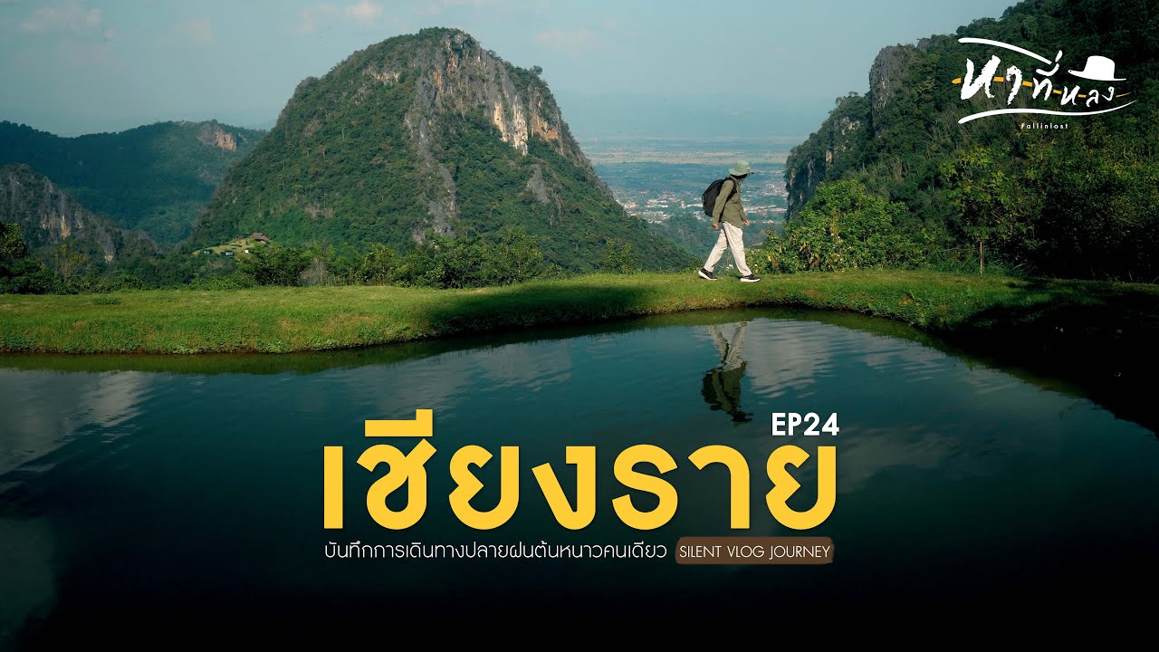
Doi Pha Chang is one of the lesser-known but highly distinctive attractions in Chiang Rai. Unlike the province’s more famous high mountain viewpoints, this place stands out for a very different reason. It consists of 3 large rocky hills rising prominently from the middle of rice fields in Don Sila Subdistrict, Wiang Chai District. That unusual landscape gives Doi Pha Chang a memorable identity. Instead of a long mountain road or a forest trek, visitors are welcomed by the striking contrast between limestone hills, open farmland, and the quiet atmosphere of a rural Chiang Rai community.
The site is located in Ban Don, Moo 8, Don Sila Subdistrict, Wiang Chai District, Chiang Rai Province. It is about 12 kilometers from Wiang Chai District and around 25 kilometers from Chiang Rai city. The usual access is via Highway 1152 on the Hua Doi–Ban Don–Phaya Mengrai–Ta route, around kilometer 18–19, then another 1.5 kilometers from the main road into the site. In practical terms, this makes Doi Pha Chang an easy destination for a short road trip. It suits travelers who want a natural attraction with local character, but without the effort of a long hike or a difficult mountain climb.
The strongest visual appeal of Doi Pha Chang comes from the way the 3 rocky hills rise above the flat agricultural landscape. Seen from a distance, they form a natural landmark that is immediately recognizable. The setting is especially attractive for photography because the hills do not sit deep inside a forest. Instead, they stand in open country, framed by rice fields, village roads, and wide skies. This gives the area a scenic quality that changes beautifully with the seasons. When the fields are green, the contrast is vivid and fresh. During drier months, the landscape becomes warmer and more rustic, creating a different but equally appealing mood.
Geologically, Doi Pha Chang is a limestone formation. The vegetation on the hills is not dense compared with heavily forested mountain areas. Most of the plants are vines, small deciduous trees, and patches of dracaena-like jan pha growing near cliff areas. This limestone character also creates another important feature of the site: caves. Local information refers to several caves in the area, including Tham Phra, Tham Pla, and Tham Khangkhao, with bats living in significant numbers. These features add ecological and geological interest to the site and make it more than a simple viewpoint.
One of the most meaningful aspects of Doi Pha Chang is its relationship with the local community. The place is not valued only for its physical beauty. It also carries strong cultural significance. In January 2006, a major community event known as the ordination of Doi Pha Chang was held here. The activity was organized under a Buddhist-inspired conservation concept called “Rak Thamma Rak Thammachat,” or roughly “Love Dhamma, Protect Nature.” During that event, a very long saffron cloth was ceremonially wrapped around the mountain, and a Buddha image called “Nawa Lan Tue” was brought up to the hill. The purpose was not only religious. It was also about environmental protection, local unity, cultural continuity, and support for sustainable tourism.
That story gives Doi Pha Chang unusual depth for a natural attraction. Visitors are not simply looking at rock hills in a field. They are looking at a place that local people have formally recognized as part of their moral and cultural landscape. This adds emotional weight to the destination and makes it especially interesting for travelers who appreciate the connection between environment, belief, and community identity in Thailand.
Access to the site has also changed over time. Local records note that there was once no road directly into the area, and people had to walk along rice field ridges to reach it. Later, the local administrative organization improved access by constructing an unpaved road into the site. That change made Doi Pha Chang easier to visit and strengthened its role as both a local recreation spot and a tourism resource. Today, it remains simple and relatively undeveloped, which is part of its charm. It still feels like a place grounded in the real landscape and daily life of Don Sila rather than a heavily commercial attraction.
A nearby attraction that pairs especially well with Doi Pha Chang is Mae Tak Reservoir, about 4 kilometers away. This medium-sized irrigation reservoir supports local agriculture and also serves as a leisure area for nearby communities. The reservoir is known for attractive scenery, especially in the hot season, and local vendors may gather there to serve visitors. This makes it easy to combine Doi Pha Chang with a second stop in the same trip, turning a short visit into a fuller local sightseeing route around Don Sila.
Getting There Doi Pha Chang is best reached by private car. From Chiang Rai city, head toward Wiang Chai District and continue to Highway 1152. Around kilometer 18–19, turn into the local road leading to the attraction for roughly 1.5 kilometers. Travelers using public transport can first reach Wiang Chai and then continue by local vehicle or hired transport into Don Sila. Because this is a rural attraction rather than a large commercial site, self-driving is the most convenient option.
Overall, Doi Pha Chang is an excellent Chiang Rai destination for travelers who want something different from the province’s mainstream mountain attractions. It offers a combination of striking natural form, open rural scenery, local cultural meaning, and nearby community-based destinations. For photography, light exploration, and a deeper appreciation of local landscape heritage, it is well worth a visit.
| Name | Doi Pha Chang / Pha Chang Don Sila / Suan Phra Ratcha Saowani Pha Chang |
| Place Summary | A group of 3 large rocky hills rising from rice fields in Don Sila, Wiang Chai, Chiang Rai, known for its natural scenery, local conservation story, caves, and community significance |
| Location | Ban Don, Moo 8, Don Sila Subdistrict, Wiang Chai District, Chiang Rai Province |
| Address | Highway 1152, around kilometer 18–19, then about 1.5 km from the main road into the attraction area |
| Highlights | 3 limestone hills in the middle of fields, rural Chiang Rai scenery, caves, local conservation story, and strong photo appeal |
| History / Significance | A culturally important natural site in Don Sila, known for the 2006 mountain ordination ceremony held under a Buddhist conservation project to protect nature and strengthen local community cooperation |
| Distinctive Features | Limestone hills with light vegetation, jan pha on cliff sections, natural caves, bat habitats, and a total area of about 124 rai |
| Travel Information | About 12 km from Wiang Chai District and 25 km from Chiang Rai city, accessible via Highway 1152 and a short local road into the site |
| Current Status | Still presented as a local attraction by Don Sila Municipality and accessible via the local road into the area |
| Open Days | Daily |
| Opening Hours | Visit Anytime |
| Facilities | Road access to the site, open photography area, nearby community attractions and supporting local services |
| Main Areas / Zones | 3 rocky hills, Tham Phra, Tham Pla, Tham Khangkhao, cliff areas, and the wider Pha Chang landscape zone |
| Caretaker | Don Sila Municipality, Wiang Chai District, Chiang Rai |
| Main Contact Number | 053-736691, 053-736053 |
| Official Website / Official Page | Don Sila Municipality |
| Nearby Tourist Attractions | 1. Mae Tak Reservoir 4 km 2. Wat Pa Sri Wilai 4 km 3. Huai Kha Waterfall 11 km 4. Nong Luang Wiang Chai 12 km 5. Wiang Chai District Office 12 km 6. Chiang Rai City 25 km |
| Nearby Restaurants | 1. Baan Nam Ngiao สูตรไทใหญ่เชียงราย 10 km, Tel. 091-858-2214 2. Ban cafe 10 km, Tel. 093-473-5853 3. Chompor Cafe 11 km, Tel. 086-429-5099 4. Ko Kae Lana Chom Pha 12 km, Tel. 082-994-3079 5. KHAM KWAN 13 km |
| Nearby Accommodations | 1. Ananya Resort 8 km, Tel. 099-006-4500 2. Ketsararat Resort & Homestay 8 km, Tel. 086-189-7115 3. Q&Bright Resort 12 km, Tel. 094-601-5665 4. The White House P&N Chiang Rai 13 km, Tel. 083-265-7959 5. Imsuk Homestay Chiang Rai 14 km, Tel. 061-825-4442 |
Frequently Asked Questions (FAQ)
Q: Where is Doi Pha Chang located?
A: It is located in Ban Don, Don Sila Subdistrict, Wiang Chai District, Chiang Rai Province, about 12 km from Wiang Chai and around 25 km from Chiang Rai city.
Q: What makes Doi Pha Chang special?
A: Its main distinction is the group of 3 limestone hills standing prominently in the middle of rice fields, together with local cultural and conservation significance.
Q: Is Doi Pha Chang difficult to access?
A: No. It is accessible by road, and from the main highway visitors only need to continue for about 1.5 km into the attraction area.
Q: Is there an entrance fee?
A: There is no confirmed current entrance fee publicly stated in the available local source material.
Q: What can visitors see there?
A: Visitors can see the 3 rocky hills, rural field scenery, cave areas, and the broader landscape associated with the local conservation story.
Q: What nearby places can be combined with this trip?
A: Mae Tak Reservoir, Wat Pa Sri Wilai, Huai Kha Waterfall, and other local spots around Don Sila and Wiang Chai can easily be added to the same route.
Q: Is Doi Pha Chang suitable for photography?
A: Yes. It is especially attractive for landscape and rural photography because the rocky hills rise clearly above the surrounding rice fields.
![]() Category: ●Nature and Wildlife
Category: ●Nature and Wildlife
![]() Group: ●Mountain (Doi)
Group: ●Mountain (Doi)
Last Update : 3 MonthAgo
Doi Pha Chang Map
Recommend


