lovethailand home >Central Travel Attractions >Phetchaburi Travel Attractions >Ban Laem >Bang Ta Bun > Bang Tabun Estuary
TL;DR: Bang Tabun Estuary is located at Chaloem Phra Kiat Bang Tabun Estuary Bridge, Bang Tabun Subdistrict, Ban Laem District, Phetchaburi, Thailand, open Daily, hours All day (best at dawn and in the late afternoon before sunset).

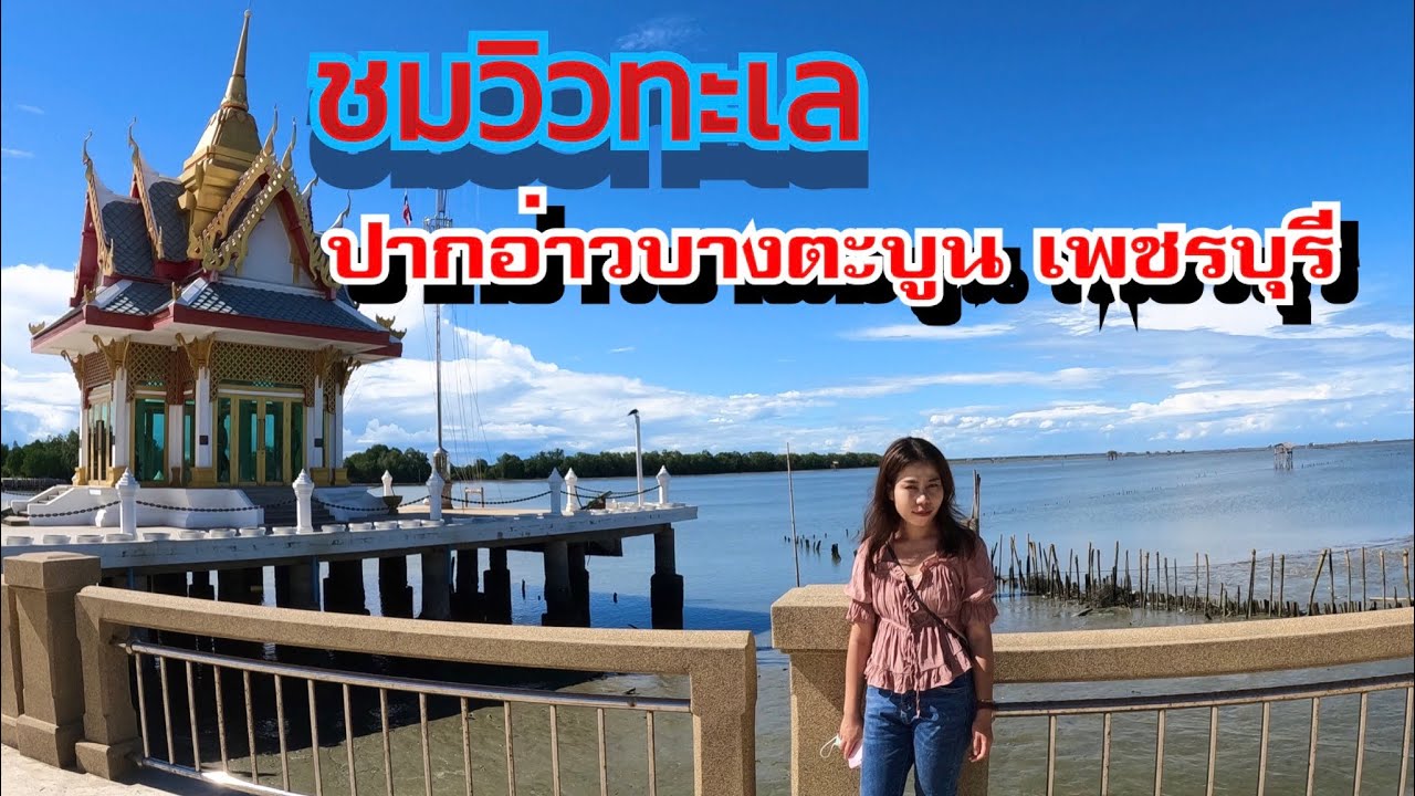
Bang Tabun Estuary

Open Days: Daily
Opening Hours: All day (best at dawn and in the late afternoon before sunset)
Bang Tabun Estuary is a scenic viewpoint where the waterway meets the Gulf of Thailand along the Ban Laem coastline in Phetchaburi. The highlight is standing on the Chaloem Phra Kiat Bang Tabun Estuary Bridge and seeing the “big picture of a living coastal community” in a single frame—oyster/mussel farming racks (ker-teng) laid out by local fishermen, small boats moving in and out of the estuary, riverside seafood restaurants and homestays, and a relaxing coastal-drive atmosphere that never feels rushed. This stop is easy to extend into a fuller day trip, especially for travelers who want seafood around Ban Laem and those planning a boat trip into the Gulf to look for Bryde’s whales in the right season.
Bang Tabun Estuary, Phetchaburi is the kind of place that makes the phrase “a coastline with real life” immediately understandable the moment you park and step onto the bridge. This is not just a pretty photo spot—it is an active working landscape where the community earns its living. In the early morning you may see small fishing boats gliding across the water with the steady sound of engines marking the day’s rhythm. Sea air from the Gulf carries a soft salty scent, and as you look outward you will notice rows of ker-teng (farming structures for shellfish) forming a grid-like pattern on the water. That is what gives Bang Tabun its distinctive charm: beauty created by everyday coastal livelihoods, not a scene staged purely for tourism.
In this setting, the word “estuary” means the threshold where river water meets the sea, so the mood and the environment change clearly with tides and wind direction. When the tide is high, the water surface feels fuller and the bridge’s shadow stretches across it, creating crisp depth in photographs. When the tide is low, the water recedes and you may see exposed sediment lines and hints of the mudflat surface—a natural window into how the estuary works. This constant change makes each visit feel different, and if you pay attention you will start to “read the sea’s rhythm” through wind sound, water color, and the movement of boats that locals already understand instinctively.
The main viewpoint is the Chaloem Phra Kiat Bang Tabun Estuary Bridge, which functions both as a key coastal connector and as a naturally elevated “viewing balcony” for travelers. From the middle of the bridge, you get wide views on both sides: one direction opens toward the estuary mouth and the sea beyond; the other reveals the riverside community with homes, restaurants, and homestays spread along the water. At certain times, sunlight breaks into tiny sparkles on the surface like fine shards of light—soft on the eyes—making photos feel clean, airy, and calm. It works equally well for a quiet walk and for a deliberate photo stop.
When it comes to the estuary’s “signature identity,” the most visible feature is the shellfish-farming system and the coastal fishing way of life that you can read directly from the bridge. The racks you see are not decorative—they are working spaces that rely on knowledge of currents, salinity, and seasons. Seeing the long rows laid out across the water is like looking at a “community economy map” drawn on the sea surface. If you arrive when locals are tending their plots, the motion of boats and people will tell the story of how closely life here is tied to the Gulf more clearly than any long explanation ever could.
Another layer that sets Bang Tabun apart from typical seaside viewpoints is the “belief and respect” woven into everyday seafaring routines. Near the estuary mouth there is a shrine to Amma that locals revere, and many people stop to make a respectful offering or say a few words before heading out by boat or taking visitors offshore. This reflects a coastal reality: boating is not just a tourist activity—it is work that requires caution and humility toward nature. If you pause to observe this practice quietly, you will understand that coastal life is not only about fish and shellfish, but also about mindset, belief, and safety moving together.
Beyond boats and shellfish, Bang Tabun is also a place many visitors enjoy for “bird watching and bird photography.” The estuary and nearby mangrove/mudflat areas provide feeding and resting grounds for various birds, especially in the cooler early morning and late afternoon. From the bridge, you may spot birds flying low over the water or perching on wooden stakes in shallow zones. The best approach is to watch from a respectful distance, keep noise down, and avoid flash or behavior that forces wildlife to move. These landscapes reveal themselves most beautifully when people simply share space without disturbing what is already there.
Another sight that stands out while driving in this zone is the “swiftlet house”—buildings constructed to attract swiftlets to nest. This is one of several coastal livelihood models found in parts of Thailand. For travelers, it adds texture to the trip because you are not only seeing the sea, but also seeing how communities diversify income streams. Even so, these activities still connect back to the estuary geography and the productivity of the coastal ecosystem that supports life here.
If you care about “light,” Bang Tabun is naturally photogenic without needing any staging. At dawn, the light is softer and golden, the water looks smooth, bridge shadows become defined, and fishing-boat shots feel beautifully documentary. Late afternoon tends to bring warmer tones and comfortable breezes, ideal for panoramic photos or simply lingering on the bridge. Midday visits are still possible, but glare can be strong from both the water and bridge surfaces, so bring a hat, sunglasses, and sunscreen—especially if you plan to stay and shoot for a while.
In terms of planning a “high-value” visit, Bang Tabun is an ideal starting point because you can get strong visuals and a real sense of place without spending much time. From here, you can continue straight into a seafood meal around Bang Tabun or Ban Laem, or—if you plan ahead—extend the day into a Gulf boat trip for Bryde’s whale viewing during suitable seasons. This is one reason Bang Tabun is often discussed among nature-focused travelers. The experience is more enjoyable and safer when you contact operators in advance, choose a day with appropriate sea conditions, and prepare basics like motion-sickness remedies, a hat, and drinking water, because offshore sun and wind can be stronger than many people expect.
Getting There If you start from Bangkok, drive toward Phetchaburi as usual, then follow the landmarks from your route notes: turn left around kilometer marker 72 (look for a PTT gas station on the left). Turn left into the exit next to the station, then at the three-way junction turn left again. Continue toward the Khlong Khon direction using local/rural roads that connect the coastal corridor. After about 7 kilometers you will reach Yi San Police Station; turn left there, then continue toward the Cha-am direction. You will arrive at the Bang Tabun Estuary area by the Chaloem Phra Kiat Bang Tabun Estuary Bridge. As you approach the bridge, slow down and choose a safe parking spot before walking up for photos.
If you do not have a private car, the most practical option is to hire a car/driver from Phetchaburi town or from the Cha-am / Chao Samran zone and ask them to take you directly to the bridge. Some smaller local roads are easier with a driver who knows the area, and multiple transfers can cost time—especially if you are aiming for dawn or late-afternoon light, which has a limited window.
Once you arrive, the smoothest approach is to match your activity order to the light and heat. In the morning, start by walking to the middle span to capture boats and shellfish racks in first light, then come down to enjoy the riverside atmosphere and visit the Amma shrine respectfully without disturbing locals, and head to seafood afterward. Morning is ideal for clean, open compositions because there are fewer people, breezes are gentler, and the sky often looks clearer. In the evening, focus on the comfortable coastal mood, photograph the long bridge shadows, and finish with seafood without rushing.
A consistent priority in estuary areas is safety on the bridge and keeping the place clean. The bridge is shared public infrastructure, and the estuary is a sensitive ecosystem. If you carry a small bag for your own trash and avoid throwing anything into the water, you help preserve the atmosphere long-term—and that also strengthens the credibility of your travel content in terms of responsible tourism.
If you want a “one-day trip that feels complete,” a balanced flow is: start early at the Chaloem Phra Kiat Bang Tabun Estuary Bridge for dawn light and fishing-life scenes, then have seafood around Bang Tabun / Ban Laem, then decide whether to continue with a whale-watching boat trip (if pre-booked) or drive on to Laem Phak Bia for a different coastal landscape, and finish by stopping at Chao Samran Beach or a nearby beach for a final seaside walk before heading back. This itinerary delivers “views–living culture–food–sea breeze” without long-distance rushing, and it remains easy to manage time-wise.
| Place Summary | A scenic estuary viewpoint on the Chaloem Phra Kiat Bridge, with views of shellfish-farming racks, coastal fishing life, riverside scenery, and Gulf-of-Thailand atmosphere; excellent for dawn and late-afternoon photography. |
| Address | Chaloem Phra Kiat Bang Tabun Estuary Bridge, Bang Tabun Subdistrict, Ban Laem District, Phetchaburi, Thailand |
| Highlights | Estuary and Gulf views, ker-teng shellfish racks, boats moving in and out with tidal rhythm, beautiful morning and evening light, easy to extend into seafood and nature boat trips. |
| History / Local Context | A river-to-sea transition zone where Bang Tabun waters flow into the Gulf; closely tied to coastal fishing and shellfish farming, and part of a coastal corridor used to connect multiple destinations in Ban Laem. |
| Travel | From Bangkok, drive toward Phetchaburi, turn left near km 72 (PTT station landmark), follow rural/coastal connecting roads via Khlong Khon – Yi San – Bang Tabun toward the Cha-am direction to reach the Bang Tabun Estuary Bridge. |
| Nearby Tourist Attractions (Distance) | 1) Bang Tabun Community (Riverside / Pier Zone) – 7 km 2) Chao Samran Beach – 22 km 3) Laem Phak Bia – 18 km 4) Puek Tian Beach – 27 km 5) Phra Ram Ratchaniwet (Ban Puen Palace) – 35 km |
| Nearby Seafood Restaurants (Distance & Phone) | 1) Bang Tabun Bay – 8 km – 082-499-9993 2) Krua Bang Tabun – 7 km – 032-581-297 3) Krua Ban Sor – 7 km – 087-151-2552 4) Mae Luk Chan (Bang Tabun Branch) – 7 km – 063-978-2645 5) Rim Thale Seafood – 7 km – 085-374-3558 |
| Nearby Accommodations (Distance & Phone) | 1) Bang Tabun Homestay – 7 km – 084-160-7879 2) Fisherman’s Resort (Chao Samran) – 22 km – 032-478-020 3) Chomtalay Resort (Chao Samran) – 22 km – 032-478-488 4) Capstone Resort (Chao Samran) – 23 km – 032-770-648 5) Seaman Resort (Chao Samran) – 22 km – 081-846-1327 |
Frequently Asked Questions (FAQ)
Q: Where is Bang Tabun Estuary, and what is the main viewpoint?
A: It is in Bang Tabun Subdistrict, Ban Laem District, Phetchaburi. The main viewpoint is the Chaloem Phra Kiat Bang Tabun Estuary Bridge, which offers clear views of the estuary mouth, shellfish racks, and the movement of fishing boats.
Q: What time is best to visit?
A: Early morning and late afternoon are best because the light is softer, temperatures are comfortable, and you get the most photogenic water-and-boat atmosphere.
Q: What stands out the most when you are on the bridge?
A: You can see the estuary opening toward the Gulf, the ker-teng shellfish racks laid out by fishermen, and boats moving in and out following the tide.
Q: If I want to extend the trip into Bryde’s whale viewing, how should I prepare?
A: Contact the operator in advance, pick a day with suitable sea conditions, and bring a hat, sunscreen, water, and motion-sickness remedies because offshore sun and wind can be stronger than on land.
Q: What should drivers be careful about on the coastal route?
A: Allow extra time, drive at an appropriate speed on rural roads that can be narrower, watch for local traffic, and park only in safe designated areas before walking onto the bridge.
![]() Category: ●Nature and Wildlife
Category: ●Nature and Wildlife
![]() Group: ●Bays and Beaches
Group: ●Bays and Beaches
Last Update : 5 MonthAgo
Bang Tabun Estuary Map
Gellery
Recommend


