lovethailand home >Central Travel Attractions >Kanchanaburi Travel Attractions >Thong Pha Phum >Phi Lok > Chokkradin Waterfall
TL;DR: Chokkradin Waterfall is located at Pilok Subdistrict, Thong Pha Phum District, Kanchanaburi Province (Thong Pha Phum National Park), open Daily, hours 08:00 – 17:00.

Chokkradin Waterfall

Open Days: Daily
Opening Hours: 08:00 – 17:00
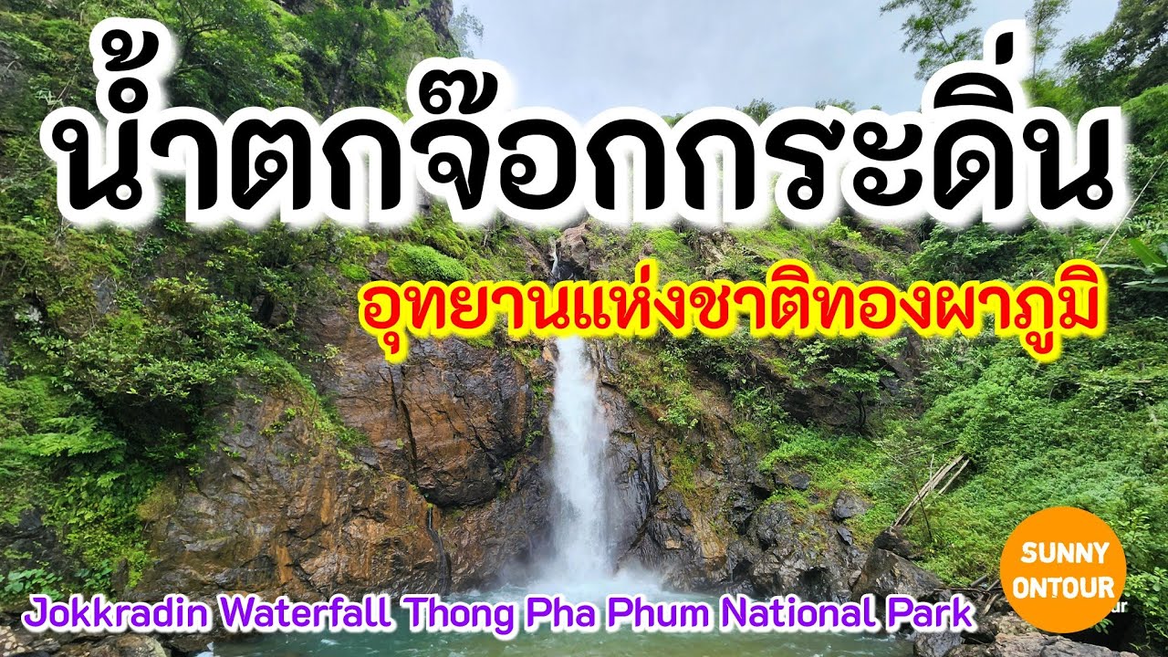
Chokkradin Waterfall is one of those places that makes it easy to fall in love with Thong Pha Phum, because it delivers a real sense of “wow” the moment you see the cliff face—yet it also gives you a kind of calm that you can feel immediately, as if you’re standing in a true forest rather than a spot designed just for quick photos. Located in Pilok Subdistrict, Thong Pha Phum District, Kanchanaburi Province, within Thong Pha Phum National Park, this is a single-tier waterfall where a clear stream pours down a cliff about 30–34 meters high. As the water hits the pool below, it creates a cool, fine mist that hangs lightly in the air. If you visit in the late rainy season or during the cool season, the entire atmosphere feels effortlessly refreshing, as though the softness of the forest is wrapped around the place.
What makes Chokkradin Waterfall special isn’t only the height of its cliff, but the overall mood that makes people want to “stay just a little longer.” There’s the color of the water—often remembered as turquoise or blue-green—which shifts depending on season, water volume, and the light inside the valley; the sound of the falling water that feels powerful without any need for amplification; and the deep shade of the surrounding trees that naturally separates this space from the rush of the outside world. Many visitors come because they’ve seen photos of the crystal-clear pool where you can make out the rocks on the bottom, or because they want to feel that famously cold water the moment it touches your feet. But once you’re actually here, what you take home is often not just a picture, but a steadier mind—the kind that comes from standing quietly and listening to a waterfall in a forested valley.
The name “Chokkradin” adds another layer of charm, because some sources explain that it connects to local border-area language and carries a meaning along the lines of a waterfall flowing through a rocky cleft. That kind of naming reflects how people in the area read the landscape: not to make it sound grand, but to describe what it truly looks like. When you watch water drop from a tall rock face, break into a delicate curtain, and gather into the pool below, it becomes easy to understand why the idea of a “rocky cleft” feels central to remembering this place. The name becomes a living description, not just a label on a sign.
Geographically, Chokkradin is a single-tier waterfall, yet the sense of “layers” comes from other elements—the rock walls framing the cliff, the slope around the pool, and the pathway that draws you closer step by step. Many travel sources note that the walk from the parking area to the waterfall is roughly 200–300 meters and generally easy, which makes this waterfall accessible to a wide range of visitors. Even though you’re in a mountainous route where careful driving matters, once you reach the parking spot the walk is not overly demanding, making it ideal for a half-day visit or as a highlight stop on a Pilok trip.
When it comes to the “best time to visit,” Chokkradin offers different kinds of beauty across seasons. During the rainy season, the forest turns deep green and the flow becomes more powerful: the water curtain thickens, the roar grows louder, and the mist can feel like a faint, natural fog around the cliff. But that beauty comes with higher risk—slippery rocks, stronger currents, and weather that changes quickly, especially after days of continuous rain. That’s why the late rainy season into early cool season is often described as the most balanced period: the water remains attractive, the forest stays lush, yet conditions are calmer and walking is more comfortable. In the cool season, the valley air can feel distinctly cold, and the water clarity often stands out as rainfall tapers off. Light filtering through the valley can also add depth to the pool and waterfall curtain, giving photos a soft, natural look without heavy editing.
The dry season sometimes makes people hesitate, worrying the flow might be low, but for a valley waterfall that many visitors describe as having water year-round, the dry season can actually be excellent for seeing details. Lower water levels can reveal clearer outlines of rock formations and the pool’s edges, and make the blue-green gradation of the water easier to notice by depth. Some parts of the path may also be drier, which suits travelers who prefer a slow visit: sitting to listen to the water, taking unhurried photos, or bringing family members while reducing the risks that come with heavy rain and sudden surges. In that sense, Chokkradin isn’t “beautiful in only one way”—its character shifts with the season, and you can choose the timing that best fits your travel style.
The most popular activity here is swimming or wading in the pool below, because the water is widely known for being clean, clear, and noticeably cold. Still, it’s important to understand that some parts of the pool can be deep, and the rocks around the waterfall often carry algae or moss, making them much more slippery than they appear. If you enter the water, choose safer areas, pay attention to the current, and avoid climbing or standing on rocks where water flows continuously. During the rainy season or right after fresh rain, extra caution is essential, because currents can intensify quickly and mountain runoff can arrive suddenly without obvious warning. The safest way to enjoy the water is to let nature set the boundary: don’t force it on days when conditions aren’t suitable, and follow park notices strictly.
Beyond swimming, Chokkradin is well suited for photography in several styles. If you like wide shots, capturing the cliff and water curtain creates a powerful, natural scale. If you prefer details, you can focus on drifting mist, rock textures shaped by erosion, and the pool’s color gradation. At certain times, sunlight slips through the canopy and catches the water curtain, creating small highlights that add depth without the need for heavy editing. On cooler days, or when Pilok’s air carries a thin mist, the whole scene can feel especially soft and atmospheric—a distinctly “cool rainforest” mood that’s hard to find at waterfalls closer to major cities.
Another angle that many articles mention only briefly is experiencing the waterfall as a place to learn from nature. Western Thailand’s forest ecosystems are diverse and fragile, and walking slowly while noticing humidity, soil and leaf scent, and bird calls can help you understand why the water looks so clear, why the air feels cooler, and why certain pockets of forest appear intensely green, as if a curtain of color is hanging over the valley. Humidity supports lichens, moss, and small plants on rocks—which adds beauty, but also signals that surfaces may be slick. Understanding these details naturally encourages more careful, respectful travel, not only travel for entertainment.
Road safety is also important to cover, because part of Pilok and E-Tong’s charm lies in their winding mountain roads with many curves. The same route leads to Chokkradin Waterfall. Many sources note that the entrance is about 5 kilometers before reaching Ban E-Tong, and from the entrance sign you drive about 2.8 kilometers to the parking area. That spur road often includes steep sections, and the return trip can feel more demanding because you climb back out of the valley. In wet weather, the pavement can be slippery and may collect soil or leaves, increasing the chance of wheel slip. Sedans do reach the site on many days based on common visitor experience, but it’s best to consider passenger load, tire condition, and driver confidence. If you’re not comfortable, hiring a local vehicle service or using a more suitable vehicle for steep roads can make the trip far more relaxed and safe.
Getting There To visit Chokkradin Waterfall, you can generally start from Kanchanaburi town and take Highway 323 toward Thong Pha Phum, then follow signs up toward Pilok/E-Tong. Once you’re on the mountain route, watch for the point about 5 kilometers before Ban E-Tong, where an entrance sign for the waterfall appears on the right. Turn in and continue on the paved road for about 2.8 kilometers to reach the parking area, then walk approximately 200–300 meters to the waterfall. The path is mostly easy, but wear shoes with good grip because the area is humid and can be slippery, especially in the rainy season.
If you want a well-rounded plan, Chokkradin fits perfectly into a “half-day + village” itinerary. Many travelers go in the morning or late morning for softer light and fewer crowds, then continue into Ban E-Tong to stroll, try local food, or take a break at a small café. You can close the day with viewpoints such as Noen Chang Suek or a border viewpoint, depending on the weather and each site’s opening times. This style of trip makes the long drive feel truly worthwhile because it combines waterfall, forest, misty mountains, and local community life in one route. The key to enjoying Pilok is to leave time buffers, avoid rushing on the road, and accept that mountain weather shifts quickly. Some days are sunny at noon but fog rolls in later, or rain arrives without warning. Bringing a rain jacket or windbreaker and planning to return before dark can significantly reduce risk and increase peace of mind.
In the end, Chokkradin Waterfall is at its best when visited with “respect,” because a waterfall and its pool are part of a delicate ecosystem. A single piece of litter can damage the memory of the entire place. Loud noise or music disrupts both other visitors and the natural environment. Scratching names into rock or carving marks is a direct destruction of natural features that took a long time to form. If we want this place to remain beautiful for years to come, the simplest and strongest approach is to travel thoughtfully: always pack out your trash and follow national park rules seriously. Chokkradin doesn’t need extra decoration—it needs care from everyone who steps into its valley.
| Place Summary | A single-tier waterfall in Thong Pha Phum National Park (Pilok area), known for its ~30–34-meter cliff, clear turquoise/blue-green pool, and an easy 200–300-meter walk from the parking area. |
| Address | Pilok Subdistrict, Thong Pha Phum District, Kanchanaburi Province (Thong Pha Phum National Park) |
| Coordinates | 14.68584, 98.38138 |
| Highlights | 1) Single-tier waterfall with a ~30–34-meter cliff 2) Clear turquoise/blue-green pool (varies by season) 3) Approximately 200–300 meters on foot from the parking area 4) Cool, valley forest atmosphere suitable for nature breaks and photography 5) Easy to combine with Ban E-Tong–Pilok and nearby viewpoints |
| Getting There | On the Pilok/E-Tong mountain route → about 5 km before Ban E-Tong, look for the entrance sign → drive in about 2.8 km to the parking area → walk about 200–300 meters to the waterfall |
| Fees | National park entrance fee: Thai adults 40 THB, Thai children 20 THB / Foreign adults 200 THB, Foreign children 100 THB |
| Current Status | A daytime-visit attraction within the national park. It’s recommended to check announcements and weather conditions before traveling, especially during the rainy season due to slippery surfaces and flash-runoff risk. |
| Contact (National Park) | 034-510-979, 098-252-0359 |
| Nearby Attractions (Approx. Distance) | 1) Ban E-Tong – Pilok Mine (approx. 7 km) 2) Pilok Mine (approx. 7 km) 3) Noen Chang Suek Viewpoint (approx. 15 km) 4) Noen Sao Thong Viewpoint (approx. 17 km) 5) Thong Pha Phum National Park (HQ/Visitor Service Area) (approx. 45 km) |
| Popular Restaurants Nearby (Approx. Distance + Phone) | 1) Krua Je Nee (Pilok) (approx. 8 km) Tel. 089-515-3528 2) Chao Mueang Cake Pilok (approx. 8 km) Tel. 098-408-6509 3) Brume Cafe N' Room (approx. 8 km) Tel. 082-258-5456 4) Ma Kin Kan (Pilok) (approx. 8 km) Tel. 062-356-6469 5) Chang Kae Classic Home (Ban E-Tong) (approx. 8 km) Tel. 083-070-1880 6) Mala Nuea Tor Nuea Yang (Ban E-Tong) (approx. 8 km) Tel. 065-229-2656 |
| Popular Accommodations Nearby (Approx. Distance + Phone) | 1) Pilok Hill House (approx. 8 km) Tel. 080-781-5702 2) E-Tong Homestay (approx. 8 km) Tel. 092-249-1915 3) Pilok My Home (approx. 8 km) Tel. 063-183-4056 4) Brume Cafe N' Room (Stay) (approx. 8 km) Tel. 082-258-5456 5) Pha Pae Homestay (approx. 18 km) Tel. 064-372-5666 |
Frequently Asked Questions (FAQ)
Q: Where is Chokkradin Waterfall located?
A: It is in Pilok Subdistrict, Thong Pha Phum District, Kanchanaburi Province, within Thong Pha Phum National Park, on the same mountain route used to reach Ban E-Tong – Pilok.
Q: How far do you have to walk to reach the waterfall?
A: From the parking area, the walk is typically about 200–300 meters. The path is generally easy, but shoes with good grip are recommended because the area can be damp and slippery.
Q: What is the best season to visit?
A: Late rainy season to early cool season is often the most comfortable, with attractive flow and lush greenery but calmer conditions. The rainy season can be very beautiful as well, though surfaces are more slippery and runoff risk is higher.
Q: Can you swim at the waterfall, and what should you watch out for?
A: Many visitors wade or swim in the pool depending on conditions, but rocks can be slippery due to algae and some areas may be deep. Avoid unstable rocks and skip swimming if heavy rain or unusually strong flow occurs.
Q: Can a sedan drive there?
A: Sedans reach the area on many days, but the mountain route has many curves and some steep sections, especially on the spur road to the parking area and on the way back up. In wet weather, consider vehicle condition and driver confidence, or use local transport for added safety.
Q: What should you prepare before visiting?
A: Non-slip shoes, drinking water, a change of clothes and towel if you plan to swim, a rain jacket or windbreaker in rainy/cool seasons, and a trash bag to pack out all waste.
![]() Category: ●Nature and Wildlife
Category: ●Nature and Wildlife
![]() Group: ●Waterfalls
Group: ●Waterfalls
Last Update : 5 MonthAgo
Chokkradin Waterfall Map
Recommend


