lovethailand home >North Travel Attractions
>Chiang Mai Travel Attractions >Doi Saket
>Luang Nuea
> Phaendin Whid
TL;DR: Phaendin Whid is located at Moo 1, Ban Pa Sak Ngam, Luang Nuea Subdistrict, Doi Saket District, Chiang Mai, Thailand, open Generally daily (recommended for daytime visits; avoid heavy-rain days), hours Recommended 06:00 – 18:00.

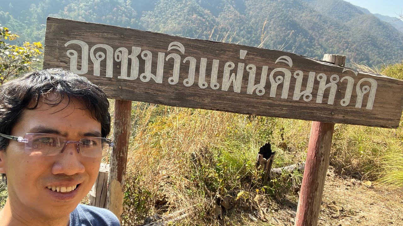
Phaendin Whid

Open Days: Generally daily (recommended for daytime visits; avoid heavy-rain days)
Opening Hours: Recommended 06:00 – 18:00
Phaendin Whid If you are looking for a “less-crowded viewpoint” in Chiang Mai that still feels genuinely natural—like stepping right up to the forest’s edge—Phaendin Whid in Moo 1, Ban Pa Sak Ngam, Luang Nuea Subdistrict, Doi Saket District is one of those quietly compelling spots. Its charm doesn’t come from constructed attractions or flashy facilities, but from the landform itself: a high-elevation area where the terrain drops away into a deep indentation, like a “hollow” or a section that looks as if the earth has been cut out. That natural void opens a wide window for viewing layered forest and mountain ridgelines belonging to the Ban Pa Sak Ngam community landscape.
In local usage, the name “Phaendin Whid” typically describes a high mountain area where part of the ground seems to be “missing” or “sunk down.” From the upper rim, you can see the lower terrain as if nature carved a vast recess that lets your gaze spill outward and downward. The viewpoint feels open, deep, and quietly beautiful—ideal for travelers who prefer sitting with the wind, letting the scenery do the talking.
What gives a visit to Phaendin Whid extra depth is the surrounding natural forest context. This area still retains the character of a community-managed natural forest, functioning both as the dramatic backdrop for the panorama and as an ecosystem that helps maintain local moisture and watershed balance. According to local information, notable plant species found in the forest include teak, bamboo (Phai Sang Nuan), mafaen, rokfa, redwood-type hardwoods, and makha. Together, these suggest a forest zone with a mix of hardwood trees and native plants well adapted to rolling upland terrain.
Many visitors describe the experience the same way: “the view arrives without effort.” Stand in the right spot and the ridgelines and forest layers appear as soft, stacked bands. Early morning is especially good when the air is still and the ridge outlines look crisp; late afternoon brings gentler light that photographs beautifully. Do plan your return time carefully, though, because roads in community and nature areas are not ideal for night driving—especially after rainfall.
Getting There From Chiang Mai city, there are two main ways to reach the village area and connect onward to the viewpoint. The first option is to take a boat across Mae Kuang Dam, which typically takes about 30 minutes, then continue to Ban Pa Sak Ngam before heading to the viewpoint. The second option is to drive: the commonly referenced distance is about 90 km, with travel time around 2 hours, generally along the Chiang Mai – Phrao route before connecting into Luang Nuea. A key recommendation is to check road conditions and weather before departure, as some sections may be laterite/gravel or narrow community roads requiring extra caution. Drive slowly and respectfully through village areas.
If you want a fuller day trip, nearby spots often paired with Phaendin Whid include Mae Kuang Udomthara Dam and the suspension bridge (often called the “Bridge of Connection”), both popular for photos. You can also add nature stops in the same zone such as Pa Sak Ngam Waterfall and a nature study trail in a spring-fed forest area (route conditions may vary, so it’s best to check locally beforehand).
For a safer and more comfortable visit, bring shoes with good grip, drinking water, mosquito repellent, and your own small trash bag. Places like this stay beautiful because visitors keep disciplined habits. If you plan to take photos near the rim, keep it simple: don’t stand too close to the edge, don’t climb unprotected points without barriers, and avoid risky shots when the ground is wet and slippery after rain.
| Name | Phaendin Whid (Phaendin Whid Viewpoint) |
| Location | Moo 1, Ban Pa Sak Ngam, Luang Nuea Subdistrict, Doi Saket District, Chiang Mai, Thailand |
| Characteristics | A community viewpoint on high ground where the land drops into a deep indentation, opening broad views of layered forests and ridgelines; a natural, low-commercial feel |
| Period | Natural landscape (upland terrain and community forest) |
| Key Evidence | Upland cliff/ridge landform and community forest environment; notable plants reported locally include teak, bamboo (Phai Sang Nuan), red hardwoods, and makha |
| Name Origin | Named after the high-ground landform where part of the terrain appears missing or deeply recessed, forming a natural viewing window |
| Travel | Boat across Mae Kuang Dam (about 30 minutes), or drive from Chiang Mai city (about 90 km; around 2 hours) via the Chiang Mai – Phrao route, then connect into Luang Nuea |
| Current Status | Community nature viewpoint (recommended for daytime visits; check road and weather conditions before travel) |
| Contact Number | — |
| Nearby Tourist Attractions (With Distance) | Mae Kuang Udomthara Dam (approx. 4 km) — Tel. 053-865-685 Mae Kuang Dam Suspension Bridge (approx. 4 km) — — Wat Doi Thaen Phra Pha Luang (approx. 7 km) — — Huai Jo Reservoir (approx. 8 km) — — Wat Phra Bat Tin Nok (approx. 8 km) — — |
| Popular Restaurants Nearby (With Distance & Phone Number) | Saneh Mae Kuang (approx. 15 km) — Tel. 087-178-1153, 098-747-3386 Boat Noodle Cherng Doi (approx. 15 km) — Tel. 092-878-8942 The Lemontree Garden & Cafe (approx. 16 km) — Tel. 093-415-0544 Tha Ruea Lung Charoen Restaurant (approx. 16 km) — Tel. 081-961-4627 Celapot Cafe x Gallary (approx. 18 km) — Tel. 082-185-2136 |
| Popular Accommodations Nearby (With Distance & Phone Number) | Soulmates Retreat (approx. 9 km) — — Tao Garden Health Spa & Resort (approx. 9 km) — Tel. 053-921-200 Rinrada Resort (approx. 27 km) — — Rabeang Pasak Treehouse (approx. 30 km) — Tel. 093-040-6494 The Rise Suites (approx. 23 km) — Tel. 052-005-696 |
| Facilities | Resting spot/shelter may be available depending on local management; bring your own water and essentials |
| Fees | — |
Frequently Asked Questions (FAQ)
Q: Where is Phaendin Whid located?
A: It is in Moo 1, Ban Pa Sak Ngam, Luang Nuea Subdistrict, Doi Saket District, Chiang Mai, and serves as a community nature viewpoint.
Q: When is the best time to visit?
A: Morning offers clearer ridge layers with calmer air; late afternoon has softer light for photos, but plan to leave early enough to return before dark.
Q: Is the route difficult?
A: Some sections may be village roads and can include gravel/laterite stretches. Drive slowly, avoid heavy-rain days, and prioritize daytime travel.
Q: Can I visit without driving?
A: One option is to take a boat across Mae Kuang Dam (about 30 minutes), then continue to the village area and onward to the viewpoint.
Q: What nearby places should I combine with this trip?
A: Mae Kuang Udomthara Dam and the suspension bridge are popular additions, and you can also consider nearby nature spots like Pa Sak Ngam Waterfall and a spring-forest nature trail (check local conditions before going).
![]() Category: ●Nature and Wildlife
Category: ●Nature and Wildlife
![]() Group: ●Other natural attractions
Group: ●Other natural attractions
Last Update : 5 MonthAgo