
lovethailand home >North Travel Attractions >Tak Travel Attractions > 40 Best Places to Visit in Tak Northern Thailand
TL;DR: 40 Best Places to Visit in Tak Northern Thailand, open Daily Opening Hours: 06:00 – 17:30.
40 Best Places to Visit in Tak Northern Thailand
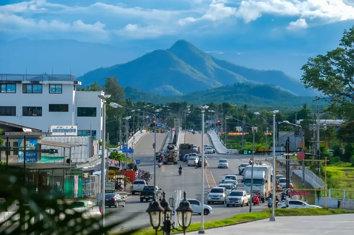
40 Best Places to Visit in Tak: Must-See Attractions in Northern Thailand Tak Province is one of the most diverse destinations in lower northern Thailand, combining spectacular nature, important historical sites, border culture, and outdoor adventure. The province covers a vast area with dramatically different landscapes, from Tak town along the Ping River and Bhumibol Dam in Sam Ngao District to the bustling border city of Mae Sot, the mountain forests of Tha Song Yang, and remote Umphang, home to the famous Thi Lo Su Waterfall. First-time visitors with only one day should focus on Tak town, the Shrine of King Taksin the Great, and attractions along the Ping River. With 2–3 days, Bhumibol Dam, Mae Sot, Rim Moei Market, and nearby national parks can be added. Travelers with 4–5 days or more should dedicate extra time to Umphang, Doi Hua Mot, Thi Lo Su Waterfall, or Tha Song Yang to experience Tak's mountains, forests, and border landscapes in greater depth.
Tak lies on the western side of lower northern Thailand and shares a long international border with Myanmar. Its strategic position makes the province an important gateway between northern and central Thailand as well as a major border-trade corridor. The eastern side of the province is closely linked with the Ping River, while the western side is dominated by mountain ranges, forests, valleys, and border communities. This geographical diversity has created remarkably different travel experiences within a single province.
Historically, Tak was formerly known as “Mueang Rahaeng” and served as an important frontier town for centuries. Its position on routes connecting the Chao Phraya Basin, northern Thailand, and the western frontier gave Tak strategic significance in trade, transportation, and military history. The province is also closely associated with King Taksin the Great, who served as governor of Tak before becoming king. The Shrine of King Taksin the Great therefore remains both a sacred landmark and an important place for understanding the province's historical identity.
Tak is also culturally diverse. Mae Sot, Phop Phra, Mae Ramat, Tha Song Yang, and Umphang are home to local Thai communities as well as Karen, Hmong, Mon, Lahu, and other ethnic groups with cultural ties across the Myanmar border. This diversity can be seen in local languages, clothing, food, religious traditions, festivals, handicrafts, and architecture. Temples in Mae Sot, in particular, often display strong Burmese and Mon artistic influences.
From a natural perspective, Tak forms part of Thailand's vast Western Forest Complex. The province contains national parks, wildlife sanctuaries, watershed forests, mountain ranges, caves, rivers, and waterfalls. Nationally known natural attractions include Thi Lo Su Waterfall, Doi Hua Mot, Taksin Maharat National Park, Lan Sang National Park, Namtok Pha Charoen National Park, and the sea-of-mist viewpoints of Mae Moei National Park.
Umphang is one of Thailand's major nature and adventure destinations. Its landscape includes large waterfalls, the Mae Klong River, limestone mountains, tropical forest, scenic viewpoints, rafting routes, and remote wildlife areas. Thi Lo Su Waterfall is the district's best-known attraction, but visiting requires advance planning because access conditions depend on the season, road conditions, weather, and official announcements from Umphang Wildlife Sanctuary.
Mae Sot presents another side of Tak. This lively border city is known for commerce, multicultural communities, Buddhist architecture, markets, and views along the Moei River. Travelers can browse Rim Moei Market, visit temples influenced by Burmese and Mon art, explore local food, and continue onward toward Phop Phra, Tha Song Yang, or Umphang.
Sam Ngao District is another important travel zone, especially because of Bhumibol Dam, one of Thailand's landmark water-management and hydroelectric projects. The vast reservoir is surrounded by mountains and connects with boat routes, remote temples, local communities, and scenic viewpoints. The area is suitable for families, photographers, engineering enthusiasts, and travelers who enjoy slow journeys by water.
Food in Tak reflects the province's geography and ethnic diversity. Travelers will find northern Thai dishes, local central-northern cuisine, Burmese-influenced food, border-market snacks, river fish, community products, highland produce, and ethnic specialties. Mae Sot offers especially varied dining, while Tak town has local markets and dishes connected with the Ping River. Popular souvenirs include highland produce, handicrafts, textiles, processed foods, coffee, pomegranates, and border-trade products.
For practical trip planning, Tak is best divided into travel zones. Tak town is suited to history, temples, shrines, and Ping River attractions. Sam Ngao focuses on Bhumibol Dam and reservoir travel. Mae Sot offers border culture, markets, temples, and multicultural experiences. Phop Phra is known for waterfalls, hot springs, and agricultural tourism. Tha Song Yang is ideal for highland forests and sea-of-mist viewpoints, while Umphang is best for travelers seeking deeper nature and adventure. Traveling zone by zone reduces unnecessary driving across this very large province.
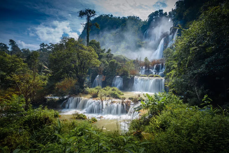
1. Thi Lo Su Waterfall is one of Thailand's most famous natural waterfalls, located inside Umphang Wildlife Sanctuary in Umphang District, Tak Province. Surrounded by the rich forests of western Thailand, the waterfall is formed by Huai Klotho flowing across a broad limestone cliff before descending in multiple levels and creating an enormous curtain of white water against dense tropical forest.
Highlights: Massive limestone waterfall, broad multi-level cascades, pristine Umphang forest, nature trails, Mae Klong River rafting, and a true adventure-travel experience that requires advance planning.
Thi Lo Su lies at an elevation of around 900 meters above sea level. The surrounding landscape consists of mountains, valleys, streams, evergreen forest, and mixed deciduous forest that form an important watershed ecosystem. Because of this ecological significance, access is controlled by Umphang Wildlife Sanctuary rather than operating like an unrestricted roadside attraction.
The waterfall is most impressive when water volumes are high. Water spreads across the broad cliff before dropping over several levels, creating huge white cascades against deep green forest. Mist fills the air and the sound of the falls echoes through the valley, giving Thi Lo Su a scale and atmosphere very different from smaller single-drop waterfalls.
Traveling to Thi Lo Su takes more preparation than visiting most attractions in Tak. The mountain road from Mae Sot to Umphang is long and winding. After reaching Umphang town, visitors must continue into the wildlife sanctuary according to seasonal access conditions. The final sections may involve mountain roads and rough tracks, so suitable vehicles or experienced local operators are commonly used.
Another popular option is to combine the journey with rafting on the Mae Klong River. Along the way, travelers pass river forest, cliffs, rapids, and the dramatic scenery of Umphang, making the journey itself part of the experience rather than simply transportation to the waterfall.
The rainy season and high-water periods usually produce the most spectacular waterfall scenery, but they can also bring road restrictions or temporary closures for safety and environmental recovery. Visitors should always check the latest official announcement from Umphang Wildlife Sanctuary instead of relying on access information from previous years.
Thi Lo Su is best suited to nature lovers, photographers, groups of friends, and travelers comfortable with multi-stage journeys. Families with very young children, elderly travelers, or people with mobility limitations should carefully consider the trip format. It can be combined with Doi Hua Mot, Thi Lo Cho Waterfall, rafting activities, and other attractions around Umphang.
Getting There: From Mae Sot, take Highway 1090 to Umphang District. From Umphang town, continue toward Umphang Wildlife Sanctuary according to the route and conditions officially announced for that period. The final section may require a suitable vehicle or transport arranged through a local operator. Contact the protected area before departure.
Map (GPS):Open Google Maps – Thi Lo Su Waterfall
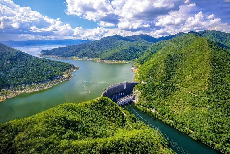
2. Bhumibol Dam is located in Sam Ngao District and is one of Tak Province's most important landmarks. It was Thailand's first major multipurpose dam and was formerly known as Yanhee Dam before receiving the royal name “Bhumibol Dam.” The dam blocks the Ping River between mountain ranges and creates a vast reservoir extending northward.
Highlights: 154-meter-high concrete arch dam, large mountain reservoir, hydroelectric power facilities, scenic viewpoints, boat and raft routes, and attractions around the upper reservoir.
Bhumibol Dam plays a major role in electricity generation, water storage, irrigation, flood management, and national water-resource planning. The main structure is a concrete arch dam designed to transfer water pressure toward the mountain shoulders on both sides. At 154 meters high from foundation to crest, it remains one of Thailand's most important hydroengineering structures.
The reservoir above the dam is surrounded by complex mountain ranges. Some areas resemble an enormous mountain lake and can be explored by boat or raft, including routes toward Ban Na Subdistrict and more remote areas upstream. Traveling by water reveals forests, mountains, islands, and reservoir communities that cannot be experienced from the road.
Photographers can enjoy views from public areas around the dam, especially in the early morning or late afternoon when the light is softer and the surrounding mountain ridges become more dramatic. Families can use the dam as an easy sightseeing stop, while visitors interested in engineering and energy can learn about one of Thailand's most influential infrastructure projects.
A visit can be expanded beyond the dam itself by combining Pha Sam Ngao, Wat Phra That Kaeng Soi, Doi Khao Nam, reservoir boat trips, or raft accommodation. Some destinations are accessible only by water and depend on reservoir levels, so boat arrangements should be confirmed before departure.
Getting There: From Tak town, take Highway 1 toward Ban Tak District, then turn onto Highway 1107 toward Sam Ngao District and Bhumibol Dam. A private vehicle is the most convenient option for exploring the dam and nearby attractions.
Map (GPS):Open Google Maps – Bhumibol Dam

3. Doi Hua Mot is one of Umphang District's best-known mountain viewpoints. Located within easy reach of Umphang town, it is especially popular for sunrise, sea-of-mist scenery, and panoramic views over limestone mountains along Thailand's western border.
Highlights: Sunrise viewpoint, sea of mist, 360-degree mountain scenery, open grass-covered ridges, and an easy combination with Thi Lo Su Waterfall and Umphang town.
The name “Hua Mot” refers to the open character of the mountain ridge, where large trees do not densely cover the summit. This creates wide views across several layers of mountain ranges, especially before sunrise when mist often settles in the valleys below.
The late rainy season through winter is the most popular period because visitors have a better chance of seeing both sunrise and mist. During the rainy season the mountains become intensely green, although roads and footpaths may be slippery.
Reaching the viewpoint does not require a long trek comparable to remote waterfall routes, but visitors should wear shoes suitable for dirt and rocky ground. A flashlight is useful before dawn, while jackets and wind protection are recommended during the cool season.
Doi Hua Mot is ideal for photographers, couples, groups of friends, and travelers staying in Umphang. It can be visited early in the morning before returning to town for rafting, waterfall trips, or other activities later in the day.
Getting There: From Umphang town, follow the local road toward Doi Hua Mot. Travelers aiming for sunrise should leave before dawn and drive carefully in darkness, mist, or wet conditions.
Map (GPS):Open Google Maps – Doi Hua Mot
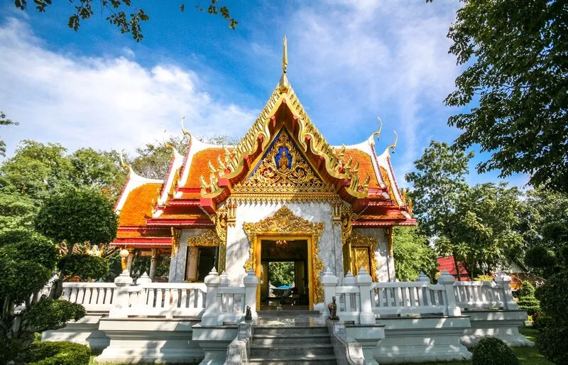
4. Shrine of King Taksin the Great is one of Tak town's most important sacred and historical landmarks. Located on Charot Withithong Road in Nong Luang Subdistrict, Mueang Tak District, the shrine commemorates King Taksin the Great, who was closely connected with Tak before becoming monarch.
Highlights: Royal statue of King Taksin the Great, one of Tak's most important spiritual centers, large numbers of votive horse statues, and a direct connection with the province's history.
King Taksin the Great played a decisive role in Thai history after the second fall of Ayutthaya. Before that period, he had served as governor of Tak. This strong relationship between the king and the province explains why his name remains deeply respected by local residents.
The shrine contains a dignified royal statue, and visitors regularly come to pay respect, pray for blessings, and fulfill vows. Numerous horse statues can be seen around the shrine, reflecting the king's image as a military commander and leader.
During important festivals and commemorative dates associated with King Taksin, the shrine becomes particularly busy. History-focused travelers can begin here before continuing to Ban Chin Alley, old temples, and the Ping River area.
The shrine is located in central Tak and is easy to visit for families, elderly travelers, and general visitors. Modest dress and respectful behavior are appropriate.
Open Days: Daily Opening Hours: 06:00 – 17:30
Getting There: The shrine is on Charot Withithong Road, Nong Luang Subdistrict, Mueang Tak District. It is easily reached by private car, motorcycle, or local transport from central Tak.
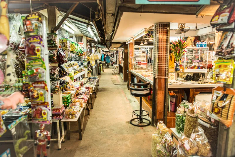
5. Rim Moei Market is one of Tak Province's best-known border markets, located in Tha Sai Luat Subdistrict, Mae Sot District, beside the Moei River and close to the First Thai–Myanmar Friendship Bridge. The market reflects Mae Sot's role as a major border-trade center and offers an accessible introduction to the region's multicultural character.
Highlights: Border market beside the Moei River, Thai and Myanmar goods, clothing, dried food, handicrafts, jewelry, souvenirs, and the atmosphere of cross-border commerce.
The market lies near the end of Highway 105, opposite Myawaddy in Myanmar. Its strategic location has made the area important for international trade as well as everyday retail activity.
Visitors will find clothing, textiles, household goods, decorative items, dried foods, accessories, imported products, and border-market souvenirs. Prices and quality vary, so comparison between shops is recommended.
The Moei River is a major part of the experience because it forms the natural border between Thailand and Myanmar. Walking near the river helps visitors understand the geography of Mae Sot more clearly than shopping alone.
Rim Moei Market can easily be combined with the Thai–Myanmar Friendship Bridge, temples in Mae Sot, and other attractions around Tha Sai Luat. It is especially suitable for travelers interested in food, trade, culture, and local border life.
Open Days: Daily Opening Hours: 08:00 – 18:00
Getting There: From Mae Sot town, take Highway 105 toward Tha Sai Luat Subdistrict and the First Thai–Myanmar Friendship Bridge. The market is beside the Moei River and can be reached by private car, motorcycle, or local transport.
Map (GPS):Open Google Maps – Rim Moei Market
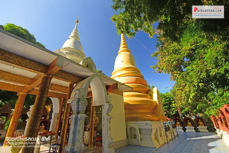
6. Wat Manee Phraison is an old Buddhist temple in central Mae Sot and one of the district's most interesting religious and architectural landmarks. Its location close to Mae Sot's market area makes it easy to combine worship, heritage, and city sightseeing.
Highlights: Samphutthe Chedi Viharn, Burmese and Mon artistic influences, numerous Buddha images, and the atmosphere of an old temple in the center of Mae Sot.
Mae Sot has long maintained cultural connections with communities across the Myanmar border. Wat Manee Phraison reflects this relationship through architecture and religious decoration that differ from temples in central Tak or central Thailand.
The temple's most distinctive structure is the Samphutthe Chedi Viharn, with its elaborate form, decorative details, and numerous Buddha images. The structure is especially interesting for cultural travelers and photographers.
Visiting the temple helps travelers understand Mae Sot as more than a commercial border town. Religion, ethnic communities, and different artistic traditions have coexisted here for generations.
The temple can be combined with Mae Sot Market, Rim Moei Market, Wat Chumphon Khiri, and other attractions in town. Visitors should dress modestly and avoid disturbing religious activities.
Open Days: Daily Opening Hours: 06:00 – 18:00
Getting There: Wat Manee Phraison is located near central Mae Sot and the market district. It is easily accessible by private car, motorcycle, local transport, or on foot from nearby areas.
Map (GPS):Open Google Maps – Wat Manee Phraison

7. Namtok Pha Charoen National Park is a mountainous protected area in Phop Phra District, known for forest scenery, waterfalls, and nature-based attractions. Its best-known feature is Pha Charoen Waterfall, a limestone cascade with numerous small levels that can be reached relatively easily.
Highlights: Pha Charoen Waterfall, multi-tiered limestone cascades, forest landscapes of Phop Phra, Huai Nam Nak Hot Spring, and convenient access to western Tak's natural attractions.
Pha Charoen Waterfall is formed by water flowing across limestone terraces, creating many small cascades rather than one large vertical drop. This gives the waterfall a distinctive layered appearance and makes it suitable for general sightseeing and photography.
The surrounding national park consists of mountain forest that plays an important role in local watershed systems. During the rainy season and shortly afterward, the forest becomes intensely green and waterfalls carry more water.
The main waterfall is easier to access than remote wilderness sites such as Thi Lo Su, making it appropriate for families, elderly visitors with normal mobility, couples, and road-trip travelers.
Nearby attractions include Huai Nam Nak Hot Spring, Thararak Waterfall, agricultural areas, and other natural sites around Phop Phra.
Open Days: Daily Opening Hours: 08:00 – 17:00
Getting There: From Mae Sot, take Highway 1090 toward Phop Phra District and follow signs into the national park. A private vehicle is recommended for combining several attractions in the area.

8. Mon Kio Lom is one of the major viewpoints in Mae Moei National Park, located in Mae Song Subdistrict, Tha Song Yang District. The high mountain ridge offers views over western mountain ranges and valleys that often fill with mist during the late rainy season and cool season.
Highlights: Sea of mist, sunrise and sunset, border mountain scenery, cool weather, Mae Moei forest, and a peaceful atmosphere suitable for overnight nature trips.
Mae Moei National Park has several mountain viewpoints, and Mon Kio Lom is one of the most popular because its open ridge offers broad views across multiple layers of mountains.
Early morning is ideal for sunrise and mist, while late afternoon offers beautiful light over the mountains. The area feels much quieter than viewpoints close to major cities.
Winter nights can be cold, so campers should prepare warm clothing, bedding, and equipment according to national park regulations. During the rainy season, roads can become slippery and visibility may be limited by fog.
Mon Kio Lom can be combined with Mae Usu Cave and other attractions in Mae Moei National Park. Because Tha Song Yang is far from Mae Sot, staying at least one night is recommended.
Getting There: From Mae Sot, take Highway 105 toward Mae Ramat and Tha Song Yang, then continue along the Mae Salit–Mae Ramoeng route, Highway 1267, following signs to Mae Moei National Park and Mon Kio Lom.
Map (GPS):Open Google Maps – Mon Kio Lom
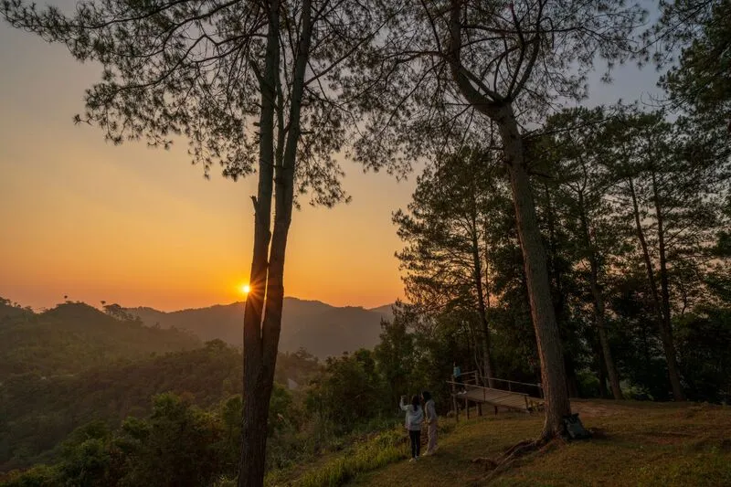
9. Taksin Maharat National Park is a large forest area along the route between Tak town and Mae Sot. The park contains evergreen forest, mixed deciduous forest, mountains, streams, waterfalls, viewpoints, and nature trails.
Highlights: Giant krabak tree several centuries old, natural stone bridge, evergreen forest, short hiking routes, camping, and historical connections with old routes between Thailand and Myanmar.
One of the park's most famous landmarks is a giant krabak tree estimated to be around 700 years old, with a trunk circumference of more than 16 meters. Reaching the tree requires a short nature trail with downhill sections.
Standing beneath such an ancient tree gives visitors a powerful sense of how long mature forest ecosystems take to develop. The tree is therefore not merely a photo spot but also a symbol of forest conservation.
The natural stone bridge is another geological attraction, created by large rock formations spanning a lower stream. Nearby caves and limestone formations add interest for visitors who enjoy geology and nature walks.
The park is also associated with historical military routes through Thailand's western frontier, adding historical context to the natural landscape.
Open Days: Daily Opening Hours: 08:30 – 16:30
Getting There: From Tak town, follow Highway 105 toward Mae Sot and turn into the park according to the signs. It is a convenient stop on the Tak–Mae Sot route.
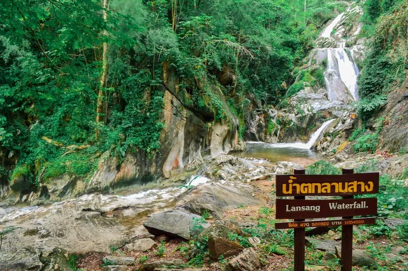
10. Lan Sang National Park is located in Mae Tho Subdistrict, Mueang Tak District, not far from Tak town. Covering roughly 65,000 rai, it contains mountains, multiple forest types, streams, and a series of waterfalls suitable for day trips or camping.
Highlights: Lan Sang Waterfall, Pha Lat Waterfall, Lan Liang Ma Waterfall, Pha Phueng Waterfall, Pha The Waterfall, Pha Noi Waterfall, Tha Le Waterfall, diverse forest ecosystems, and local legends connected with King Taksin the Great.
The terrain rises toward the west and south before descending eastward, creating streams such as Huai Lan Sang and other waterways that feed several waterfalls.
Forest types include evergreen forest, pine forest, hill evergreen forest, dipterocarp forest, and mixed deciduous forest, giving visitors opportunities to observe changing vegetation with elevation.
The park's waterfalls have different characters: some flow across broad rock surfaces, some drop from cliffs, and others lie deeper within valleys. Visitors can choose routes according to available time and fitness level.
The name “Lan Sang” is associated with a local legend involving King Taksin the Great and a historical journey through the forest at dawn, adding cultural meaning to the natural landscape.
Open Days: Daily Opening Hours: 08:30 – 16:30
Getting There: From Tak town, take Highway 105 toward Mae Sot for around 20 km, then follow signs into the park. It can easily be combined with Taksin Maharat National Park.

11. Thai–Myanmar Friendship Bridge No. 1 is a major landmark in Tha Sai Luat Subdistrict, Mae Sot District. Crossing the Moei River between Thailand and Myawaddy in Myanmar, the bridge symbolizes Mae Sot's role as a center of international transport, border trade, and cultural exchange.
Highlights: 420-meter bridge over the Moei River, Mae Sot–Myawaddy border connection, international trade corridor, river scenery, and easy access to Rim Moei Market.
The bridge is about 13 meters wide and plays an important role in passenger movement, freight transport, logistics, and cross-border economic activity.
The Moei River serves as the natural international boundary, but culturally the river has long connected people on both sides through language, food, religion, trade, and family relationships.
Rim Moei Market and local communities are located nearby, allowing visitors to experience several aspects of border life within the same area.
Cross-border travel depends on immigration regulations, security conditions, and official announcements. Visitors planning to enter Myanmar should check current requirements directly with the responsible authorities.
Getting There: From Mae Sot town, follow Highway 105 toward Tha Sai Luat Subdistrict, Rim Moei Market, and the border checkpoint.
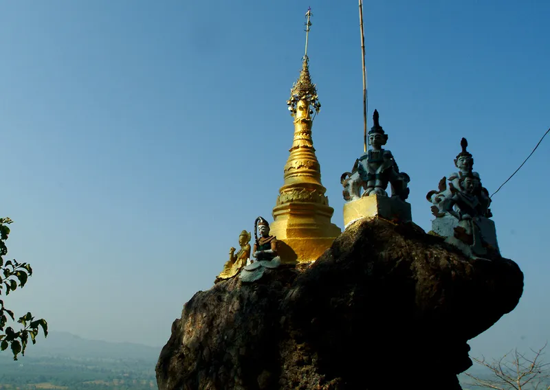
12. Phra That Hin Kio at Doi Din Chi is an important sacred site at Ban Wang Takhian in Tha Sai Luat Subdistrict, Mae Sot District. Its defining feature is a small golden Mon-style chedi built on top of a large naturally balanced rock with a narrow base, often compared with Kyaiktiyo Pagoda in Myanmar.
Highlights: Golden chedi on a balanced rock, Mon-influenced Buddhist art, mountain views, and an important local pilgrimage tradition.
The narrow base of the large rock creates the striking appearance of a huge boulder balanced on a small contact point. This unusual landform became associated with local faith and eventually supported the construction of the sacred chedi.
The site reflects Mon and Burmese artistic influences commonly found in the Mae Sot border area. It functions not only as a viewpoint but also as a living place of Buddhist devotion.
During pilgrimage festivals, worshippers travel from surrounding areas to make merit. Outside festival periods, the site offers a quiet atmosphere and can be combined with Rim Moei Market and the Friendship Bridge.
Getting There: From Mae Sot, travel toward Tha Sai Luat Subdistrict and Ban Wang Takhian, then follow the local road toward Doi Din Chi. Daytime travel is recommended.
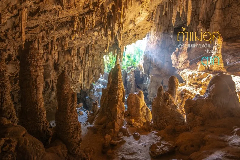
13. Mae Usu Cave is a large limestone cave in Mae Moei National Park, Mae Usu Subdistrict, Tha Song Yang District. A stream flows directly through the cave, creating an unusual landscape of large chambers, running water, stalactites, stalagmites, and natural light openings.
Highlights: Large limestone cave, stream flowing through the interior, high chambers, rock formations, natural light shafts, and a distinctive nature experience within Mae Moei National Park.
The cave is strongly influenced by water levels and seasonal conditions. During the rainy season, rising stream levels can make entry unsafe.
Inside are several chambers where sunlight enters through natural openings and reflects on limestone surfaces. Some sections are wet and slippery, so footwear with good grip is essential.
Visitors should follow official guidance, avoid entering alone, and never leave designated routes. Families with children or elderly travelers should assess conditions carefully.
Mae Usu Cave can be combined with Mon Kio Lom and other attractions in Mae Moei National Park. An overnight stay in Tha Song Yang is recommended because of the long distance from Mae Sot.
Open Days: Generally accessible during the dry season, November – April Opening Hours: 07:00 – 17:00
Getting There: From Mae Sot, follow Highway 105 toward Tha Song Yang and Mae Sariang. Near Mae Usu Subdistrict, take the local road toward the cave. Check park announcements before traveling.
Map (GPS):Open Google Maps – Mae Usu Cave
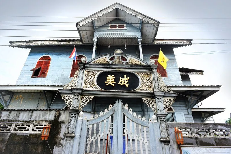
14. Trok Ban Chin is an old Chinese community on Taksin Road in Rahaeng Subdistrict, Mueang Tak District, close to the Ping River and Wat Sitalaram. The neighborhood preserves wooden houses and traces of Tak's historic river-based trading economy.
Highlights: Historic wooden houses, Thai-Chinese community heritage, Ping River trading history, traditional architecture, and an atmospheric old-town walking route.
In the past, the Ping River was one of the principal transport routes between central and northern Thailand. Goods were transported upriver before being unloaded and redistributed to surrounding towns, helping Tak develop into an important commercial center.
Chinese merchants established homes and businesses in the area, gradually forming a commercial community of residences, shops, warehouses, and river-trade connections.
Today the appeal of Trok Ban Chin lies in slow exploration. Visitors can observe wooden façades, doors, windows, ventilation details, and different architectural influences preserved within the community.
The area is best combined with Wat Sitalaram, the Ping River, and other historic attractions in Tak town. Morning and late afternoon are more comfortable for walking and photography.
Open Days: Community area accessible daily
Getting There: Trok Ban Chin is on Taksin Road in Rahaeng Subdistrict, close to Wat Sitalaram and the Ping River.
Map (GPS):Open Google Maps – Trok Ban Chin
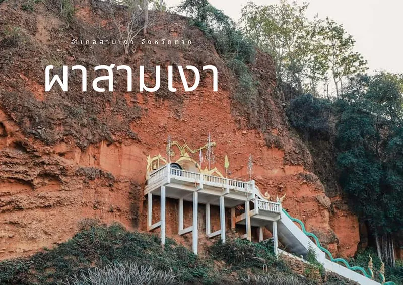
15. Pha Sam Ngao (Phra Sam Ngao) is an important historic and sacred site in Yan Ri Subdistrict, Sam Ngao District, along the Ban Tak–Bhumibol Dam route. The cliff contains 3 recessed niches, each housing a Buddha image, giving the site its name.
Highlights: Three Buddha images set into a cliff, Ping River historical landscape, Queen Chamadevi legend, and convenient access on the route to Bhumibol Dam.
Unlike conventional temples, the Buddha images are set directly within the rock face rather than inside a viharn or ordination hall, creating a distinctive relationship between landscape and religion.
Local tradition connects the site with Queen Chamadevi during her journey north along the Ping River toward Hariphunchai. The story describes the appearance of three sacred shadows on the cliff before Buddha images were created there.
The legend reflects the importance of the Ping River as an ancient travel corridor and the cultural connections between central and northern settlements.
Getting There: Pha Sam Ngao is in Yan Ri Subdistrict on the Ban Tak–Bhumibol Dam route. From Tak town, travel toward Ban Tak and continue toward Sam Ngao District.
Map (GPS):Open Google Maps – Pha Sam Ngao

16. Thararak Waterfall (Pha Chan Waterfall) is located at Ban Chedi Kho in Mahawan Subdistrict, Mae Sot District, along the Mae Sot–Umphang route. The waterfall drops from a limestone cliff into a pool surrounded by green mountain scenery.
Highlights: Approximately 30-meter limestone waterfall, steep cliff scenery, lower pool, easy access, and a useful stop on the Mae Sot–Phop Phra–Umphang route.
The waterfall is also locally called Pha Chan Waterfall, referring to the steep cliff over which the water flows. Its water system is connected with limestone geology and underground seepage.
The site lies close to Highway 1090, with a short access road of around 700 meters, making it more accessible than remote waterfalls.
Resting areas and walking spaces near the base make the waterfall suitable for short stops or longer breaks.
Open Days: Daily Opening Hours: 08:00 – 17:00
Getting There: From Mae Sot, take Highway 1090 toward Phop Phra and Umphang. Near Ban Chedi Kho, turn onto the access road for approximately 700 meters.
Map (GPS):Open Google Maps – Thararak Waterfall

17. Huai Nam Nak Hot Spring is a natural hot spring at Ban Huai Nam Nak in Phop Phra District, within the wider Namtok Pha Charoen National Park area. It is a relaxing stop between mountain, waterfall, and border routes.
Highlights: Natural hot water around 60 degrees Celsius, foot-soaking areas, peaceful rural scenery, and convenient access on the Phop Phra travel route.
The hot spring is formed by underground water heated naturally before rising to the surface. Because the source temperature is high, direct prolonged contact with the hottest water should be avoided.
Visitor facilities include resting pavilions, walking areas, and designated zones where the warm water can be enjoyed more safely.
The surrounding landscape includes hills, agricultural land, forest, and local villages, creating a very different atmosphere from a commercial spa resort.
Open Days: Daily Opening Hours: 08:30 – 17:00
Getting There: The hot spring is at Ban Huai Nam Nak, Phop Phra Subdistrict. From Mae Sot, travel toward Phop Phra and follow the local road to the village.
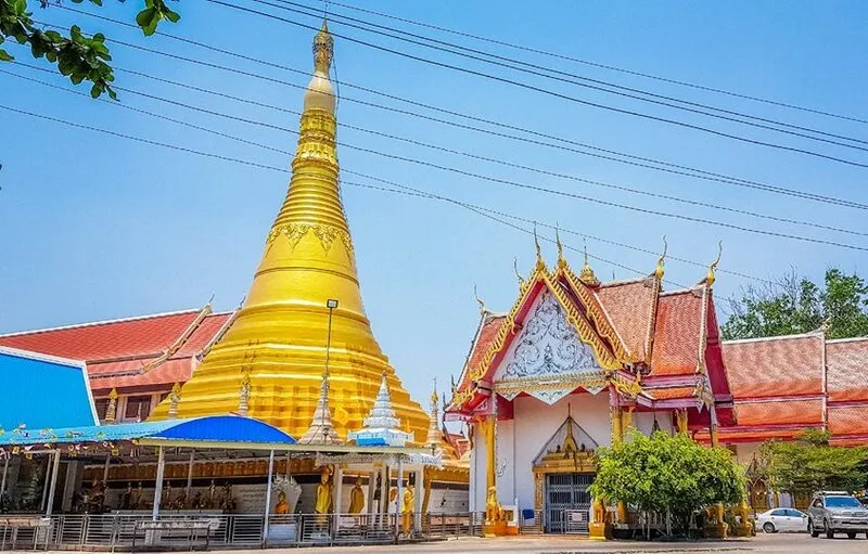
18. Wat Chumphon Khiri is one of Mae Sot's oldest temples, with a history of more than 200 years. Formerly known as Wat Klang because of its central location in the community, it reflects both local Buddhist faith and the cultural connections of the Thai–Myanmar border region.
Highlights: Golden chedi inspired by Shwedagon Pagoda, principal Buddha image in the Mara Vichai posture, ancient drum, and border-influenced Buddhist architecture.
The temple was established around 1771 and has remained an important Buddhist center for merit-making, ceremonies, community gatherings, and religious education.
Its golden chedi reflects strong Burmese artistic influence, while an ancient drum more than 200 years old preserves evidence of the temple's former role as a communication center for the local community.
Wat Chumphon Khiri can be combined with Wat Manee Phraison, the King Naresuan Shrine, Mae Sot Market, and other central Mae Sot attractions.
Open Days: Daily Opening Hours: 08:00 – 16:30
Getting There: The temple is located within Mae Sot Municipality near the town center and is easily accessible by car, motorcycle, or local transport.
Map (GPS):Open Google Maps – Wat Chumphon Khiri
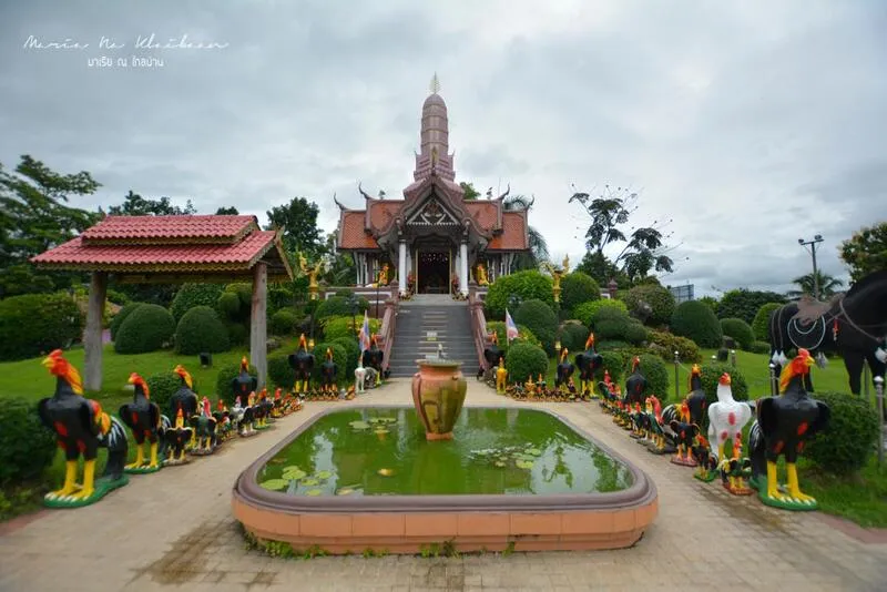
19. King Naresuan the Great Shrine is located in Mae Sot opposite the municipal sports stadium. The shrine commemorates King Naresuan the Great and is associated with the western historical route following his declaration of independence from Hongsawadi.
Highlights: Monument to King Naresuan the Great, life-size war elephant statues, numerous fighting-rooster offerings, and historical associations with the Mae Lamao frontier route.
The shrine was established in 2002 to commemorate the king and the historic western routes connected with Mae Sot and Mae Lamao.
The site demonstrates that Mae Sot has strategic historical importance beyond its modern economic role as a border city.
Visitors will see elephant statues and many rooster figures offered according to popular beliefs surrounding King Naresuan.
Open Days: Daily
Getting There: The shrine is opposite Mae Sot Municipal Stadium and near the Dipangkorn Rasmijoti Science and Environment Learning Park.

20. Wat Phra Borommathat Ban Tak is one of the most important temples in Ban Tak District, located in Ko Taphao Subdistrict in the historic old Tak area. The temple is known for its golden relic stupa and the revered Luang Pho Than Chai Buddha image.
Highlights: Golden Phra Borommathat stupa, Year of the Horse zodiac relic temple, Luang Pho Than Chai, carved teak architecture, old viharn, and Ban Tak's historical connection with the Ping River.
The temple stands on the western side of the Ping River in the area that served as Tak's former urban center before the town moved to present-day Rahaeng.
The golden stupa was built in a style inspired by Shwedagon Pagoda in Myanmar and covers an older stupa within. Smaller stupas and Buddha niches surround the main structure.
According to local Buddhist belief, the temple is associated with the Year of the Horse. Luang Pho Than Chai is another highly revered Buddha image visited by worshippers seeking blessings and success.
The temple's ordination hall contains notable carved teak details, decorative gables, and Buddhist artistic elements that add architectural value to the sacred site.
Open Days: Daily Opening Hours: 06:00 – 18:00
Getting There: From Tak town, travel toward Ban Tak District and Ko Taphao Subdistrict. The temple is easily reached by private vehicle and can be combined with Yutthahatthi Pagoda and Sam Ngao attractions.
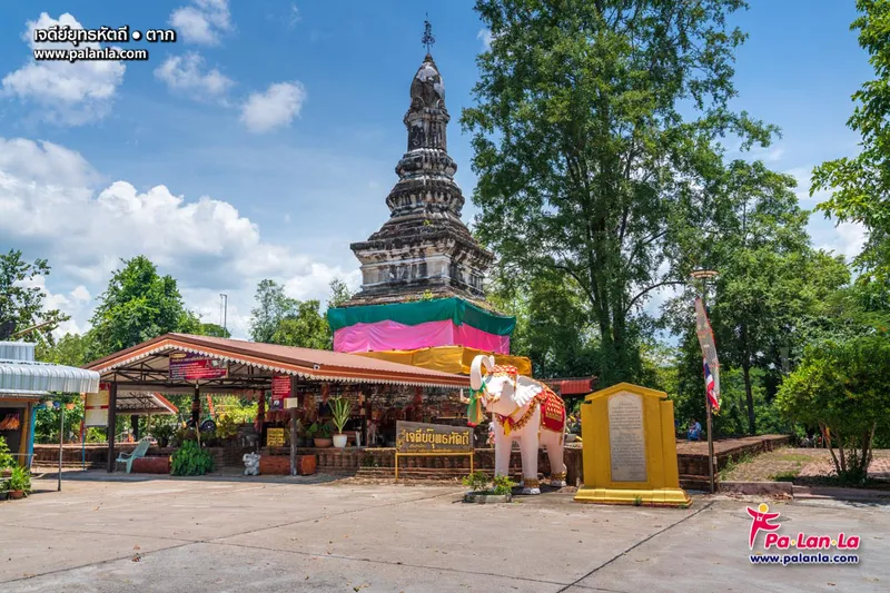
21. Yutthahatthi Pagoda is an important historic chedi on Doi Chang in Ko Taphao Subdistrict, Ban Tak District, about 200 meters from Wat Phra Borommathat. It is also known locally as the Elephant Battle Pagoda because of traditional associations with King Ramkhamhaeng the Great and Khun Sam Chon of Mueang Chot.
Highlights: Approximately 700-year-old Sukhothai-style chedi, lotus-bud-shaped finial, historical elephant-battle tradition, and close proximity to Wat Phra Borommathat.
The brick-and-stucco chedi has a base about 12 meters wide and rises approximately 16 meters. Its architectural form reflects Sukhothai artistic traditions.
Doi Chang is not a particularly high mountain, but its location within the old Tak area gives it historical significance along routes connecting central Thailand, the north, and western frontier zones.
The site's traditional association with early Sukhothai military history makes it especially valuable for visitors interested in historical geography rather than simply architecture.
Open Days: Daily
Getting There: From Tak town, travel to Ban Tak District and Wat Phra Borommathat. Yutthahatthi Pagoda is on Doi Chang nearby.
Map (GPS):Open Google Maps – Yutthahatthi Pagoda

22. Rattanakosin 200th Anniversary Suspension Bridge is a landmark across the Ping River in Tak town. Built in 1982 to commemorate the 200th anniversary of Bangkok's Rattanakosin era, the bridge has become a popular walking, photography, and evening viewpoint.
Highlights: Approximately 700-meter suspension bridge, Ping River views, wooden walkway, evening atmosphere, and decorative lighting after dark.
The bridge is approximately 2.5 meters wide and uses concrete towers, suspension cables, and a wooden walkway. Its cables create strong visual lines for photography.
Although the bridge once had a greater transport function, it is now better known as a recreational landmark where local people walk, exercise, and enjoy the river breeze.
The Ping River has shaped Tak's settlement, commerce, agriculture, and transportation for generations. Walking across the bridge offers a clear view of the relationship between the city and the river.
Open Days: Daily
Getting There: The bridge crosses the Ping River between Tak town and Pa Mamuang Subdistrict. Parking is available in surrounding urban areas before walking onto the bridge.
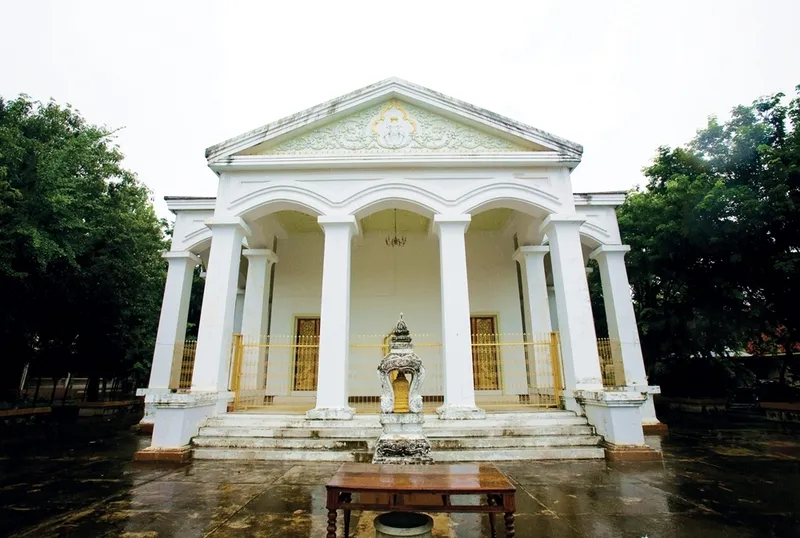
23. Wat Sitalaram (Wat Nam Hak) is an old temple on Taksin Road in Rahaeng Subdistrict, Mueang Tak District, near the historic community and Ping River.
Highlights: Historic Wat Nam Hak name, old wooden buildings, European-influenced architectural details, important Buddha images, and location near Trok Ban Chin.
The former name “Wat Nam Hak” is associated with the old river landscape where water from Huai Mae Tho met the Ping River and caused the current to change direction near the temple.
The story illustrates how waterways influenced place names and everyday life in historic Tak.
The temple also preserves older buildings and architectural details that reflect changing influences during Tak's development in the Rattanakosin period.
Because it is close to Trok Ban Chin, the temple fits naturally into an old-town walking route combining Chinese heritage, Buddhist culture, wooden architecture, and the Ping River.
Open Days: Daily
Getting There: Wat Sitalaram is on Taksin Road in Rahaeng Subdistrict, close to Trok Ban Chin and the Ping River.
Map (GPS):Open Google Maps – Wat Sitalaram

24. Thi Lo Cho Waterfall (Sai Fon Waterfall) is a waterfall in Umphang District with a very different character from Thi Lo Su. Water falls from a high cliff and breaks into fine droplets resembling rainfall, giving rise to the name “Sai Fon Waterfall,” meaning Rainfall Waterfall.
Highlights: Fine spray resembling rain, high riverside cliff, Umphang forest, and a memorable viewpoint along rafting routes on the Mae Klong River.
The waterfall's distinctive appearance is created as water drops from the cliff and disperses into fine white mist. Wind can carry the spray outward like light rainfall.
The experience is closely linked with rafting and river travel, allowing visitors to see cliffs, forest, and mountain scenery along the Mae Klong River.
Water volume and spray conditions change seasonally. Activities may be modified when water levels are too high or weather becomes unsuitable.
Getting There: Thi Lo Cho is in Umphang District and is commonly visited as part of a rafting or river excursion. Arrange the trip through an experienced local operator and check river conditions before departure.
Map (GPS):Open Google Maps – Thi Lo Cho Waterfall
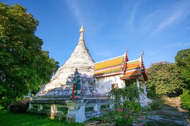
25. Wat Bot Mani Si Bun Rueang is an old temple in Nong Luang Subdistrict, Mueang Tak District. Established in 1858, it preserves important religious architecture and Buddha images connected with the development of Tak during the Rattanakosin period.
Highlights: Old ordination hall from the reign of King Rama IV, Sukhothai-style principal Buddha image, Buddhist architecture, and a quiet atmosphere within Tak town.
The temple dates to the mid-19th century, when Tak's urban community was developing around Rahaeng and nearby districts.
The principal Buddha image reflects Sukhothai artistic influence, showing how earlier artistic traditions continued to shape religious life in later periods.
The temple is well suited to visitors interested in old Tak, especially when combined with Trok Ban Chin, Wat Sitalaram, and the Shrine of King Taksin the Great.
Open Days: Daily
Getting There: Located at Ban Rommani on Taksin Road, Nong Luang Subdistrict, Mueang Tak District.

26. Huai Mae Sot Reservoir is a peaceful reservoir near Ban Hua Fai in Phra That Pha Daeng Subdistrict, Mae Sot District, surrounded by the mountain landscapes of western Tak.
Highlights: Reservoir views, Mae Sot mountain scenery, quiet atmosphere, sunset photography, and an easy nature break close to town.
The reservoir contributes to local water management while also creating an attractive open landscape of water and mountains.
Late afternoon is especially pleasant because temperatures are cooler and soft light reflects across the water.
This is not a large activity-based attraction, making it best for simple relaxation, walking, photography, or a scenic break during a Mae Sot road trip.
Open Days: Daily
Getting There: Located near Ban Hua Fai, Phra That Pha Daeng Subdistrict, Mae Sot District. Private car or motorcycle is the most convenient option.

27. Nang Khruan Waterfall is a medium-sized limestone waterfall in Phop Phra District, located near the route before reaching the district center.
Highlights: Small multi-level limestone cascades, shaded surroundings, convenient location on the Phop Phra route, and easy combination with Huai Nam Nak Hot Spring and Namtok Pha Charoen National Park.
The waterfall is smaller and quieter than Thi Lo Su or Pha Charoen, giving visitors a more local nature experience.
Water volume varies seasonally. The late rainy season usually offers greener surroundings and stronger water flow.
Limestone surfaces can become slippery when wet, so visitors should wear suitable footwear and avoid unsafe sections after heavy rain.
Getting There: The waterfall is near Highway 1206 before reaching Phop Phra town. Private transport is recommended.
Map (GPS):Open Google Maps – Nang Khruan Waterfall
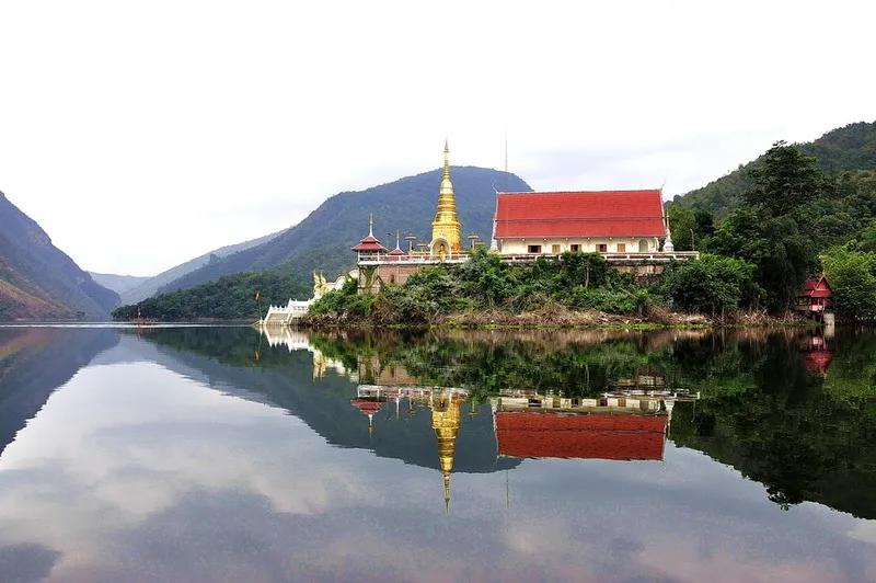
28. Wat Phra That Kaeng Soi is an old sacred site in Ban Na Subdistrict, Sam Ngao District, located within the Bhumibol Dam reservoir area. Access is mainly by boat or raft, making it one of Tak's most distinctive water-based pilgrimage destinations.
Highlights: Ancient sacred stupa, legends of old Kaeng Soi, boat journey across Bhumibol Reservoir, Mae Ping lake scenery, and a peaceful remote temple atmosphere.
Before Bhumibol Dam was built, Kaeng Soi was part of a community along the Ping River. When reservoir water levels rose, much of the original landscape became submerged and the temple became accessible primarily by water.
The journey itself is part of the experience, passing wide expanses of water and surrounding mountain ranges before reaching the temple.
Local religious traditions connect the site with sacred relic beliefs, Queen Chamadevi, and long-standing Lanna Buddhist pilgrimage culture.
Boat schedules, water levels, and weather conditions should be checked before traveling.
Open Days: According to boat access and current conditions
Getting There: The temple is in Ban Na Subdistrict within Bhumibol Reservoir. Travel is by boat or raft from a designated pier or operator around the dam.

29. Doi Khao Nam is a mountain rising from the Bhumibol Dam reservoir in Ban Na Subdistrict, Sam Ngao District. It is also associated with Wat Phra Phutthabat Khao Nam and a sacred Buddha footprint on the summit.
Highlights: Mountain rising from Bhumibol Reservoir, sacred Buddha footprint, water-based pilgrimage route, panoramic Mae Ping Lake scenery, and mountain hiking.
From a distance the mountain resembles an island rising from the reservoir. The boat journey offers progressively closer views of the mountain against the surrounding lake and ridges.
The summit area contains a revered Buddha footprint and religious structures used by local worshippers.
The climb requires moderate physical effort, so visitors should wear secure shoes, carry drinking water, and prepare sun protection.
Travelers should allow at least half a day for the boat journey, hike, worship, sightseeing, and return trip.
Getting There: Doi Khao Nam is inside Bhumibol Reservoir and requires a boat from the dam area or another designated pier, followed by a hike to the summit.
Map (GPS):Open Google Maps – Doi Khao Nam

30. Muser Market is a popular roadside highland market on Highway 105 between Tak town and Mae Sot. Also known as Doi Muser Hill Tribe Market, it is one of the most distinctive rest stops on the mountain route.
Highlights: Highland vegetables and fruit, Doi Muser coffee, local food, Lahu handicrafts, seasonal produce, and a distinctive ethnic-market atmosphere.
The market is closely associated with Lahu communities living in the surrounding highlands. Much of the produce comes directly from nearby farms and households.
Available produce changes throughout the year and may include corn, sweet potatoes, pumpkins, cool-climate vegetables, avocados, passion fruit, oranges, strawberries, and other mountain crops.
Doi Muser coffee is another popular product, reflecting the development of highland agriculture in the area.
Textiles, clothing, jewelry, and small handicrafts also provide visitors with opportunities to support local producers.
Open Days: Daily Opening Hours: 08:00 – 18:00
Getting There: The market is directly beside Highway 105 on Doi Muser between Tak town and Mae Sot.
Map (GPS):Open Google Maps – Muser Market
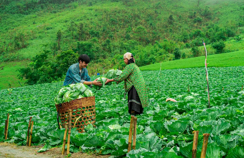
31. Doi Muser Horticultural Experiment Station, officially known today as the Tak Agricultural Research and Development Center, is an important highland agricultural learning center at Ban Muser in Mae Tho Subdistrict, Mueang Tak District.
Highlights: Highland crop research, arabica coffee, tea, vegetables, fruit, ornamental plants, cool-climate agriculture, and convenient access near Muser Market.
The center stands at around 900 meters above sea level, where cooler temperatures and higher humidity create suitable conditions for research into arabica coffee, tea, fruits, vegetables, and flowers.
Its role extends beyond tourism to plant research, crop improvement, pest management, and agricultural knowledge transfer for highland farmers.
Arabica coffee is especially important here because elevation and temperature influence bean quality, flavor, disease management, and post-harvest processing.
Open Days: Monday – Sunday Opening Hours: 08:00 – 16:30
Getting There: Located at Ban Muser, Moo 6, Mae Tho Subdistrict, along Highway 105 on the Tak–Mae Sot route.

32. Wat Phra Chedi Wang Khrai is an old temple at Ban Wang Khrai, Wang Man Subdistrict, Sam Ngao District. The temple is centered around an old chedi that existed before the temple was formally established.
Highlights: Historic chedi, community Buddhist traditions, annual chedi merit-making ceremony on April 16, and convenient location on routes toward Bhumibol Dam.
The temple was established in 1927 through the cooperation of Wang Khrai villagers, providing a community religious center around the existing sacred chedi.
The chedi remains the spiritual heart of the temple and is the focus of the annual post-Songkran merit-making ceremony.
The temple's quiet rural atmosphere offers a very different experience from larger tourist temples.
Open Days: Daily
Getting There: The temple is in Ban Wang Khrai, Wang Man Subdistrict, Sam Ngao District, around 5 km from the main road toward Bhumibol Dam.
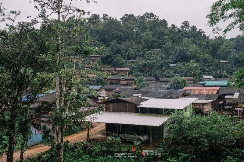
33. Hill Tribe Development and Welfare Center is a learning area on Doi Muser associated with community development, livelihoods, and cooperation with ethnic highland communities in Tak Province.
Highlights: Highland community life, Lahu, Hmong, and Lisu cultures, mountain agriculture, Doi Muser scenery, and the history of highland community development.
Doi Muser is culturally diverse, with ethnic communities maintaining distinctive languages, clothing, traditions, foods, and local knowledge.
The center has historically supported livelihoods, agriculture, and improvements in quality of life suited to highland conditions.
The surrounding area includes agricultural plots, local markets, and highland communities, allowing travelers to combine the visit with Muser Market and the horticultural research station.
Visitors interested in entering working or educational areas should contact the responsible staff in advance.
Getting There: Located in the Doi Muser area along Highway 105 on the Tak–Mae Sot route.

34. Wat Phra Phutthabat Doi Lon is a forest meditation temple in Thong Fa Subdistrict, Ban Tak District. Its most visible landmark is the enormous Buddha image known as Somdet Maha Sakyamuni Si Sanphet, standing prominently against the surrounding mountain landscape.
Highlights: Giant Buddha image approximately 20 meters across the lap and 38 meters high, peaceful forest-temple atmosphere, sacred Buddha footprint, mountain scenery, and meditation environment.
The temple differs from urban temples because it is surrounded by forest and mountain terrain, creating a quiet environment suited to meditation and Buddhist practice.
The giant Buddha image dominates the landscape and can be seen from a considerable distance.
The temple's name also reflects the importance of the sacred Buddha footprint worshipped by the local community.
Open Days: Daily
Getting There: The temple is in Moo 3, Thong Fa Subdistrict, Ban Tak District. Private transport is recommended because the access roads pass through hilly rural terrain.

35. Rose Farms are agricultural attractions around Ban Seri Rat in Chong Khaep Subdistrict, Phop Phra District. The cooler highland climate makes the area suitable for flowers, vegetables, and specialty agricultural production.
Highlights: Highland rose cultivation, rural Phop Phra scenery, flower-farming knowledge, photography, and easy combination with Pha Charoen and Thararak waterfalls.
Phop Phra is one of Tak's important agricultural districts because its elevation and climate allow the cultivation of crops that differ from those grown in hotter lowland areas.
Visitors can learn about real commercial flower production, including plot management, plant care, harvesting, and quality selection.
Flower conditions vary with the season and production cycle, so visitors should contact the farm before traveling if photography is the main purpose.
Getting There: The farms are around Ban Seri Rat, Moo 6, Chong Khaep Subdistrict, Phop Phra District. Use the Mae Sot–Phop Phra route and local roads.
Map (GPS):Open Google Maps – Rose Farms

36. Mae Kasa Waterfall is a local natural waterfall in Mae Kasa Subdistrict between Mae Sot and Mae Ramat. It is suitable for travelers seeking a quieter community-level nature stop.
Highlights: Forest stream, natural pools, shaded surroundings, local scenery, and easy combination with Mae Kasa Hot Spring.
The waterfall flows across rocks within a moist forest environment. Water levels vary seasonally, with the rainy and post-rainy periods usually producing greener scenery and stronger flow.
The attraction is smaller and less developed than Thi Lo Su or Pha Charoen, giving it a more local and natural atmosphere.
Visitors should be cautious on slippery rocks and avoid entering deep or fast-flowing water after heavy rain.
Getting There: Located in Mae Kasa Subdistrict on the Mae Sot–Mae Ramat route near the access toward Ban Mae Kuet Sam Tha.
Map (GPS):Open Google Maps – Mae Kasa Waterfall
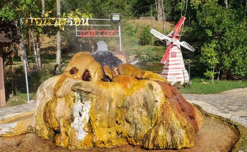
37. Mae Ka Sa Hot Spring and Mae Usa Cave combine a natural geothermal spring with limestone cave scenery in Mae Kasa Subdistrict, Mae Sot District.
Highlights: Natural hot spring, foot-soaking areas, egg boiling, limestone cave, and convenient combination with Mae Kasa Waterfall.
Hot water rises naturally from underground and can be seen bubbling in the hottest source areas. Some sections have been developed into safer visitor-use zones.
Foot soaking is a popular activity, especially after long drives through the mountain areas of Mae Sot and Mae Ramat.
The nearby cave adds geological variety, allowing visitors to experience both geothermal activity and limestone formations in the same area.
Open Days: Daily Opening Hours: 08:00 – 18:00
Getting There: Located in Mae Kasa Subdistrict, Mae Sot District. Follow the Mae Sot–Mae Ramat route and local signs.

38. Khun Phawo National Park covers mountainous areas of Mae Ramat and Mae Sot districts. The park contains watershed forest, waterfalls, viewpoints, nature trails, birdwatching opportunities, and camping areas.
Highlights: Thanon Thong Chai mountain forest, waterfalls, nature trails, birdwatching, camping, and historical connections with Phawo, a frontier figure associated with the era of King Taksin the Great.
The park covers approximately 247,957 rai, or about 396.7 square kilometers, with elevations ranging from roughly 350 to 900 meters above sea level.
The area was formerly known as Mae Kasa National Park before receiving the name Khun Phawo National Park in honor of Phawo, a Karen soldier associated with the old Mae Lamao frontier.
The park therefore combines ecological value with the history of Thailand's western frontier.
Open Days: Daily Opening Hours: 08:30 – 16:30
Getting There: The park headquarters is at Ban Nong Luang, Sam Muen Subdistrict, Mae Ramat District, on Highway 1175 between Mae Ramat and Ban Tak.
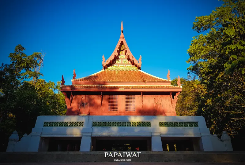
39. Wat Phothikhun (Wat Huai Toei) is a forest meditation temple at Ban Huai Toei, Mae Pa Subdistrict, Mae Sot District, beside Highway 105. Its main architectural landmark is a large three-level ordination hall shaped like a ship.
Highlights: Ship-shaped ordination hall, forest-monastery atmosphere, meditation setting, distinctive Buddhist architecture, and convenient location on the Tak–Mae Sot route.
The temple differs from urban temples because it is surrounded by trees and quiet natural space, creating an atmosphere suitable for meditation.
The large ordination hall is the architectural centerpiece and took many years to complete, reflecting sustained community faith and craftsmanship.
Because the temple follows a forest-monastery tradition, visitors should speak quietly, dress modestly, and respect meditation areas.
Open Days: Daily
Getting There: The temple is at 64/1 Moo 6, Ban Huai Toei, Mae Pa Subdistrict, around 11 km from Mae Sot town beside Highway 105.
Map (GPS):Open Google Maps – Wat Phothikhun

40. Theppithak Garden (Tubtim Garden) is an agricultural tourism site in Chong Khaep Subdistrict, Phop Phra District. The garden is known for developing high-quality pomegranates, particularly the Si Panya and Si Siam varieties.
Highlights: Si Panya and Si Siam pomegranates, agricultural learning, orchard visits, fresh produce, and local products from Phop Phra.
Si Panya pomegranates are known for large fruit, red flesh and seeds, sweet flavor, and attractive appearance, making them suitable for both fresh consumption and processing.
The garden demonstrates Phop Phra's potential as a highland agricultural district capable of producing specialty crops with added market value.
Peak production periods are generally around April–June and November–December, although pomegranates may be available at other times depending on the crop cycle.
Visitors can learn about orchard management, fruit selection, and production while purchasing fresh pomegranates directly from the area.
Open Days: Daily Opening Hours: 09:00 – 17:00
Getting There: The garden is in Chong Khaep Subdistrict, Phop Phra District, on the Mae Sot–Phop Phra route.
Map (GPS):Open Google Maps – Theppithak Garden
| Travel Category | Recommended Places |
| Nature & Waterfalls | 1. Thi Lo Su Waterfall 2. Namtok Pha Charoen National Park 3. Lan Sang National Park 4. Thararak Waterfall 5. Thi Lo Cho Waterfall 6. Nang Khruan Waterfall 7. Mae Kasa Waterfall 8. Khun Phawo National Park |
| Mountains, Mist & Viewpoints | 1. Doi Hua Mot 2. Mon Kio Lom 3. Taksin Maharat National Park 4. Doi Khao Nam 5. Khun Phawo National Park |
| History & Heritage | 1. Shrine of King Taksin the Great 2. Trok Ban Chin 3. Pha Sam Ngao 4. Yutthahatthi Pagoda 5. Wat Phra Borommathat Ban Tak 6. King Naresuan the Great Shrine |
| Temples & Sacred Places | 1. Wat Phra Borommathat Ban Tak 2. Phra That Hin Kio at Doi Din Chi 3. Wat Manee Phraison 4. Wat Chumphon Khiri 5. Wat Sitalaram 6. Wat Bot Mani Si Bun Rueang 7. Wat Phra That Kaeng Soi 8. Wat Phra Phutthabat Doi Lon 9. Wat Phra Chedi Wang Khrai 10. Wat Phothikhun |
| Thai–Myanmar Border Culture | 1. Rim Moei Market 2. Thai–Myanmar Friendship Bridge No. 1 3. Wat Manee Phraison 4. Wat Chumphon Khiri 5. Phra That Hin Kio at Doi Din Chi 6. King Naresuan the Great Shrine |
| Reservoir & Water-Based Travel | 1. Bhumibol Dam 2. Wat Phra That Kaeng Soi 3. Doi Khao Nam 4. Huai Mae Sot Reservoir |
| Hot Springs & Relaxation | 1. Huai Nam Nak Hot Spring 2. Mae Ka Sa Hot Spring and Mae Usa Cave 3. Huai Mae Sot Reservoir |
| Agriculture & Community Life | 1. Muser Market 2. Doi Muser Horticultural Experiment Station 3. Hill Tribe Development and Welfare Center 4. Rose Farms 5. Theppithak Garden |
| Family-Friendly | 1. Bhumibol Dam 2. Shrine of King Taksin the Great 3. Rim Moei Market 4. Thararak Waterfall 5. Huai Nam Nak Hot Spring 6. Doi Muser Horticultural Experiment Station 7. Theppithak Garden 8. Rattanakosin 200th Anniversary Suspension Bridge |
| Best for Photography | 1. Thi Lo Su Waterfall 2. Doi Hua Mot 3. Mon Kio Lom 4. Bhumibol Dam 5. Phra That Hin Kio at Doi Din Chi 6. Thi Lo Cho Waterfall 7. Doi Khao Nam 8. Rattanakosin 200th Anniversary Suspension Bridge |
| Adventure Travel | 1. Thi Lo Su Waterfall 2. Thi Lo Cho Waterfall 3. Mae Usu Cave 4. Mon Kio Lom 5. Taksin Maharat National Park 6. Khun Phawo National Park 7. Doi Khao Nam |
| Tak Town Zone | Shrine of King Taksin the Great, Trok Ban Chin, Rattanakosin 200th Anniversary Suspension Bridge, Wat Sitalaram, Wat Bot Mani Si Bun Rueang, Lan Sang National Park, Taksin Maharat National Park, Muser Market, and Doi Muser Horticultural Experiment Station |
| Ban Tak–Sam Ngao Zone | Wat Phra Borommathat Ban Tak, Yutthahatthi Pagoda, Wat Phra Phutthabat Doi Lon, Wat Phra Chedi Wang Khrai, Pha Sam Ngao, Bhumibol Dam, Wat Phra That Kaeng Soi, and Doi Khao Nam |
| Mae Sot Zone | Rim Moei Market, Thai–Myanmar Friendship Bridge No. 1, Phra That Hin Kio at Doi Din Chi, Wat Manee Phraison, Wat Chumphon Khiri, King Naresuan the Great Shrine, Huai Mae Sot Reservoir, Mae Kasa Waterfall, Mae Ka Sa Hot Spring, and Wat Phothikhun |
| Phop Phra Zone | Namtok Pha Charoen National Park, Thararak Waterfall, Huai Nam Nak Hot Spring, Nang Khruan Waterfall, Rose Farms, and Theppithak Garden |
| Mae Ramat–Tha Song Yang Zone | Khun Phawo National Park, Mon Kio Lom, Mae Usu Cave, and Mae Moei National Park nature routes |
| Umphang Zone | Thi Lo Su Waterfall, Doi Hua Mot, Thi Lo Cho Waterfall, and Mae Klong River rafting activities |
| Tak in 1 Day — Tak Town | Shrine of King Taksin the Great → Trok Ban Chin → Wat Sitalaram → Wat Bot Mani Si Bun Rueang → Rattanakosin 200th Anniversary Suspension Bridge |
| Tak in 1 Day — Ban Tak & Bhumibol Dam | Wat Phra Borommathat Ban Tak → Yutthahatthi Pagoda → Pha Sam Ngao → Wat Phra Chedi Wang Khrai → Bhumibol Dam |
| Mae Sot in 1 Day | Wat Manee Phraison → Wat Chumphon Khiri → King Naresuan the Great Shrine → Phra That Hin Kio → Rim Moei Market → Thai–Myanmar Friendship Bridge No. 1 |
| Phop Phra in 1 Day | Thararak Waterfall → Namtok Pha Charoen National Park → Huai Nam Nak Hot Spring → Rose Farms → Theppithak Garden |
| Tak 2 Days / 1 Night | Day 1: Tak town → Lan Sang National Park → Muser Market → Mae Sot Day 2: Mae Sot temples → Phra That Hin Kio → Rim Moei Market → Thai–Myanmar Friendship Bridge |
| Tak 3 Days / 2 Nights | Day 1: Tak town and Ban Tak Day 2: Mae Sot and the Moei border area Day 3: Phop Phra → Pha Charoen → Thararak Waterfall → Huai Nam Nak Hot Spring |
| Umphang 3 Days / 2 Nights | Day 1: Mae Sot → Highway 1090 → Umphang Day 2: Doi Hua Mot → rafting → Thi Lo Cho → Thi Lo Su according to current access conditions Day 3: Explore around Umphang and return to Mae Sot |
| Tak 4–5 Days | Divide the trip between 2 main zones: Tak town or Bhumibol Dam for 1–2 nights and Mae Sot or Phop Phra for 2–3 nights. Add separate travel days if including Umphang because of the long mountain journey. |
| Visiting All 40 Attractions | Allow approximately 7–10 days and divide the province into Tak–Ban Tak–Sam Ngao, Doi Muser–Mae Sot, Phop Phra, Mae Ramat–Tha Song Yang, and Umphang zones. |
| Best Time to Visit | November–February is ideal for mountains, mist, hiking, temples, and city travel. The late rainy season is excellent for waterfalls and lush forests, but access to remote protected areas should always be checked before departure. |
| Getting Around Tak | A private car or rental vehicle is the most convenient choice because attractions are spread across many districts. Mountain roads toward Mae Sot, Umphang, and Tha Song Yang include many bends and steep sections. |
| Souvenirs & Local Products | Doi Muser coffee, highland vegetables and fruit, Phop Phra pomegranates, seasonal produce, ethnic handicrafts, woven textiles, local food products, and border-market goods from Mae Sot and Rim Moei Market. |
| Important Travel Note | Protected areas, waterfalls, hiking routes, rafting, reservoir boat trips, and border crossings can change according to weather, water levels, seasonal restrictions, and official announcements. Always check current conditions before traveling. |
Frequently Asked Questions (FAQ)
Q: Where should first-time visitors go in Tak Province?
A: First-time visitors should consider the Shrine of King Taksin the Great, Bhumibol Dam, Rim Moei Market, Thi Lo Su Waterfall, Doi Hua Mot, Lan Sang National Park, and Taksin Maharat National Park. Together, these places represent Tak's history, nature, border culture, and mountain landscapes.
Q: How should I plan a one-day trip in Tak?
A: Choose only one travel zone. In Tak town, visit the Shrine of King Taksin the Great, Trok Ban Chin, Wat Sitalaram, and the Rattanakosin 200th Anniversary Suspension Bridge. Alternatively, explore Ban Tak and Sam Ngao with Wat Phra Borommathat, Yutthahatthi Pagoda, Pha Sam Ngao, and Bhumibol Dam.
Q: Is 2 days and 1 night enough for Tak?
A: It is enough for two major zones, such as Tak town and Mae Sot, but not enough to include Umphang or Tha Song Yang comfortably. Travelers wanting a deeper nature-focused trip should allow at least 3–5 days.
Q: What is the best time to visit Thi Lo Su Waterfall?
A: The post-rainy period through early winter usually offers impressive water volume and lush forest. However, access depends on official announcements, road conditions, weather, and environmental management by Umphang Wildlife Sanctuary.
Q: Can I visit Thi Lo Su Waterfall as a day trip from Mae Sot?
A: It is not recommended. The journey from Mae Sot to Umphang takes several hours on winding mountain roads, and additional travel is required to reach the waterfall area. At least 2 nights in Umphang is a more practical plan.
Q: Where can I see a sea of mist in Tak?
A: Doi Hua Mot in Umphang and Mon Kio Lom in Mae Moei National Park are among the best-known viewpoints. The late rainy season through winter offers a higher chance of mist, although conditions depend on humidity, wind, and weather.
Q: Which Tak attractions are suitable for families?
A: Bhumibol Dam, the Shrine of King Taksin the Great, Rim Moei Market, Thararak Waterfall, Huai Nam Nak Hot Spring, Doi Muser Horticultural Experiment Station, Theppithak Garden, and the Rattanakosin Suspension Bridge are relatively easy to access and do not require demanding trekking.
Q: What are the best historical attractions in Tak?
A: Important historical places include the Shrine of King Taksin the Great, Trok Ban Chin, Wat Phra Borommathat Ban Tak, Yutthahatthi Pagoda, Pha Sam Ngao, King Naresuan the Great Shrine, and old temples in Tak town.
Q: What should I visit in Mae Sot?
A: Major Mae Sot attractions include Rim Moei Market, the Thai–Myanmar Friendship Bridge No. 1, Phra That Hin Kio at Doi Din Chi, Wat Manee Phraison, Wat Chumphon Khiri, King Naresuan the Great Shrine, Wat Phothikhun, and natural attractions around Mae Kasa.
Q: What is there to do in Phop Phra?
A: Phop Phra is ideal for nature and agricultural travel, with Namtok Pha Charoen National Park, Thararak Waterfall, Huai Nam Nak Hot Spring, Nang Khruan Waterfall, Rose Farms, and Theppithak Garden.
Q: What can I visit in Sam Ngao besides Bhumibol Dam?
A: Other attractions include Pha Sam Ngao, Wat Phra Chedi Wang Khrai, Wat Phra That Kaeng Soi, and Doi Khao Nam, as well as boat and raft trips across Bhumibol Reservoir.
Q: What is the best season for traveling around Tak Province?
A: November–February is generally the most comfortable period because of cooler weather, clearer mountain views, and pleasant conditions for city sightseeing. The late rainy season is excellent for waterfalls and green forests but requires closer attention to road and park conditions.
Q: Do I need a private car to travel around Tak?
A: Not for every attraction in Tak town or central Mae Sot, but a private or rental vehicle is strongly recommended for traveling between districts such as Phop Phra, Sam Ngao, Tha Song Yang, and Umphang.
Q: Is the road from Mae Sot to Umphang difficult to drive?
A: The road contains many mountain bends and requires careful driving. Drivers should be well rested, check brakes and tires, avoid rushing, and take extra care during rain, fog, or darkness.
Q: Can travelers cross into Myanmar from Rim Moei Market?
A: Cross-border travel depends on current immigration rules, border-security conditions, and official checkpoint operations. Travelers should verify the latest information from Thai authorities before departure rather than relying on older opening information.
Q: How many days are needed to visit all 40 attractions?
A: Approximately 7–10 days is more realistic because Tak is a very large province. The most efficient approach is to divide the trip into Tak–Ban Tak–Sam Ngao, Doi Muser–Mae Sot, Phop Phra, Mae Ramat–Tha Song Yang, and Umphang zones.
 Category: ●Travel Articles, Recipes
 Group: ●Travel Review, Food Review
Last Update : 3 WeekAgo
 Last Update : 3 WeekAgo
Recommend

 Art, Culture and Heritage
 Historical Sites and Monuments(2)
 Landmarks and Memorials(3)
 Art, Craft Centres, Tradition(6)
 Historic Homes and Cities(2)
 Educational Places
 Educational Gardens, Farm(2)
 Places of Worship
 Temple(22)
 Other Sacred Sites(9)
 Research and Development
 Royal Project(1)
 Suburban Living
 Village, Community(5)
 Local Market(3)
 Nature and Wildlife
 National Parks and Marine Reserves(11)
 Mountain (Doi)(9)
 Dam, Reservoir, Lake(14)
 Waterfalls(23)
 Hot Springs(2)
 Caves(6)
 River, Canal(1)
 Bays and Beaches(1)
 Islands(1)
 Other natural attractions(1)
 Entertainment and Agricultural
 Farms, Parks and Ecotourism(5)
 Outdoor and Adventure Activities(4)
Travel Review, Food Review(1)


