
lovethailand home >North Travel Attractions >Tak Travel Attractions >Sam Ngao >Sam Ngao > Bhumibol Dam
TL;DR: Bhumibol Dam is located at Sam Ngao Subdistrict, Sam Ngao District, Tak Province, open Open to visitors in designated public areas, hours Best visited during daytime and late afternoon before sunset.
Bhumibol Dam
Open Days: Open to visitors in designated public areas
Opening Hours: Best visited during daytime and late afternoon before sunset
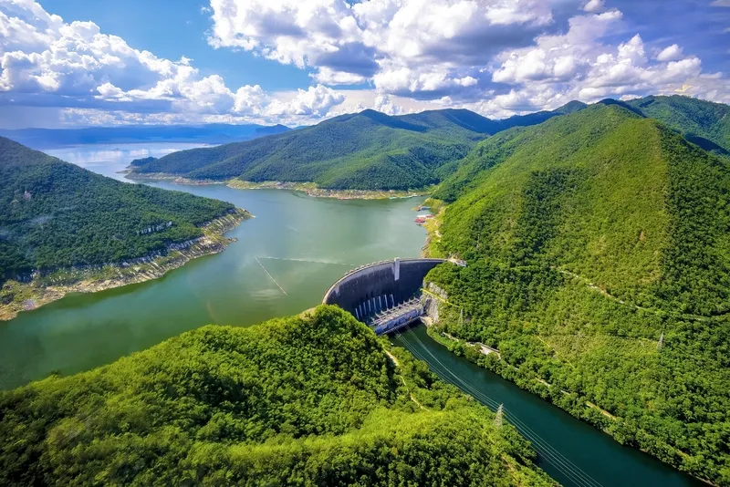
Bhumibol Dam in Tak Province, also known by its former name Yanhi Dam, is one of Thailand’s most important engineering, energy, water-management, and travel landmarks. Located in Sam Ngao District, Tak Province, the dam blocks the Ping River at Khao Kaew and forms a vast reservoir surrounded by mountains and forested landscapes. It is Thailand’s first multipurpose dam and is widely known as a large curved concrete dam with a height of 154 meters from base to crest. For travelers, Bhumibol Dam is not only an impressive structure but also a scenic destination where visitors can enjoy reservoir views, boat trips, floating raft excursions, nature routes, riverside relaxation, and a deeper understanding of how water, energy, agriculture, and daily life are connected in Thailand.
Bhumibol Dam is a meaningful place for both Thai visitors and foreign travelers because it represents a major period in Thailand’s modern development. The dam was formerly called Yanhi Dam, a name associated with the local area, before His Majesty King Bhumibol Adulyadej granted the official name “Bhumibol Dam” on 25 July 1957. The dam officially began operation on 17 May 1964 and has since become a symbol of hydropower development, large-scale water management, and national infrastructure. Its story is closely linked with electricity generation, irrigation, flood mitigation, freshwater fisheries, agriculture, and tourism in northern and central Thailand.
From an engineering perspective, Bhumibol Dam is especially remarkable because it is a curved concrete dam constructed between mountain slopes on the Ping River. The curved structure allows the pressure of the stored water to be transferred toward the rock shoulders on both sides, giving the dam strength and stability. When visitors stand at a viewpoint or look across the crest area, the sweeping arc of the dam against the mountain backdrop creates a powerful impression. The scale of the concrete wall, the depth of the valley, and the vast reservoir behind it make this one of the most striking dam landscapes in Thailand.
The main function of Bhumibol Dam is to store water for multiple national purposes. Water in the reservoir supports hydropower generation, irrigation, agricultural production, flood control, dry-season water supply, and freshwater fisheries. This makes the dam much more than a tourist attraction. It is a working water-resource system that helps support farms, communities, and electricity users far beyond Tak Province. For travelers who are interested in how infrastructure shapes everyday life, Bhumibol Dam offers a clear and memorable example of a place where nature, engineering, and public benefit meet.
The reservoir above the dam stretches far north along the Ping River toward Hot District in Chiang Mai Province. The waterway from the dam toward the upper Ping River is more than 200 kilometers long, creating a lake-like landscape among mountains, forests, rocky slopes, and remote riverside sites. Because of this long reservoir route, Bhumibol Dam is not only a viewpoint near the dam crest but also a gateway to one of northern Thailand’s most scenic inland water journeys. This is why boat trips and floating raft excursions are among the most popular experiences here.
Floating raft and boat trips on Bhumibol Reservoir allow visitors to experience the landscape from the water. Depending on the route and service availability, travelers may pass natural and cultural sites such as Phra Phutthabat Khao Nam, Valentine Island, Doi Chao Pho Luang, Khao Phra Phutthabat, Tham Ap Nang, Kaeng Soi archaeological area, and routes toward Doi Tao in Chiang Mai Province. These trips reveal the scale of the reservoir, the beauty of the surrounding hills, and the quiet atmosphere of the upper Ping River. For many travelers, seeing the dam from the water gives a very different impression from simply viewing it from the crest.
One of the important cultural sites connected with the reservoir route is Wat Phra Borommathat Kaeng Soi, located in an area mainly reached by boat or floating raft. This site reflects the older cultural landscape of the Ping River basin before the modern reservoir transformed the area. Traveling by boat to places like Kaeng Soi helps visitors understand that Bhumibol Reservoir is not only a hydropower lake. It is also connected with local history, Buddhist devotion, old settlements, and the geography of the northern river system.
Within the Bhumibol Dam area, there are several scenic and leisure points suitable for a half-day or full-day trip. These include the dam crest, reservoir viewpoints, the Thai-style house exhibition area, Ping Phifat Bridge, the 50th Anniversary Bridge, Luang Pho Chet Kasat, Mae Ping Beach, Lan Pho Market, Huai Phu Kaeo Restaurant, Khun Saichol Coffee, and guesthouse areas. The dam crest is the classic photo spot where visitors can appreciate the curve of the dam and the reservoir behind it. Other nearby zones provide a more relaxed setting for walking, photography, dining, and family leisure.
Mae Ping Beach is one of the more casual recreation areas in the dam zone. It is suitable for resting by the river, enjoying the breeze, taking photos, and spending time with friends or family. Visitors should follow all local rules, especially those related to water safety, restricted areas, and cleanliness. Bhumibol Dam remains an operational water and energy facility, so responsible travel is essential. Tourists should not enter restricted zones, should not swim in unsafe or prohibited areas, and should always follow signs and instructions from staff.
For photographers, Bhumibol Dam offers many attractive angles. In the morning, soft light and cooler air create calm landscape scenes, while late afternoon brings warmer tones over the reservoir and mountains. The water level, season, sky conditions, and forest color can change the appearance of the dam dramatically. During the rainy season and early cool season, the surrounding hills are often greener and more atmospheric. In the dry season, the edge of the reservoir and rocky slopes may become more visible, giving the scenery a different character.
Nature lovers may also be interested in the nature-study routes around the upper Ping River and Mae Tuen National Reserved Forest. These routes introduce visitors to dry dipterocarp forest, mixed deciduous forest, rocky landscapes, streams, waterfalls, and forest-restoration areas. They help travelers understand the ecological importance of the watershed above the dam. Such routes are best experienced with proper preparation and local guidance, especially when they involve walking trails, remote areas, or boat access.
Conservation-minded travel is important around Bhumibol Dam because the reservoir connects water, forest, wildlife, fish, and local communities. Visitors should avoid littering, avoid disturbing wildlife, stay on appropriate routes, and use boat or raft services responsibly. Plastic waste, food containers, and fishing waste can affect the reservoir environment. Travelers who join boat trips or visit natural areas should bring back all rubbish and respect both the ecosystem and the communities connected with the reservoir.
For families, Bhumibol Dam is best enjoyed at a relaxed pace. A simple itinerary may include scenic viewpoints, the dam crest, the Thai-style house area, a meal inside the dam zone, and a quiet break near the water. Families with children should keep them away from steep edges, deep water, and restricted areas. Elderly visitors may prefer viewpoints and dining areas that require minimal walking. Those who wish to stay overnight can choose guesthouses inside the dam area or nearby accommodations in Sam Ngao or Tak town.
Travelers interested in energy and infrastructure will find Bhumibol Dam particularly meaningful. Hydropower generation uses the force of water released through turbines to produce electricity. At Bhumibol Dam, this process is tied to broader water-management decisions, including irrigation release, reservoir storage, river-flow regulation, and flood mitigation. A visit here can help travelers see how one large dam can influence agriculture, electricity supply, downstream water levels, and regional development over many decades.
The landscape setting is one of the strongest reasons to visit Bhumibol Dam. From higher viewpoints, the reservoir appears like a long lake among mountains. The curved dam wall, the deep valley, the power station below, and the broad water surface above create a dramatic composition. Even travelers who do not join a boat trip can enjoy the atmosphere simply by walking, taking photos, and looking out over the water. The sense of scale is difficult to understand from photographs alone and is best appreciated in person.
Getting There is most convenient by private car or rental car. From Mueang Tak, drive toward Sam Ngao District and continue to the Bhumibol Dam area, a distance of roughly 50–60 kilometers depending on the starting point and route. The main road is generally suitable for normal vehicles, but drivers should allow enough time and drive carefully on district roads. Travelers coming from Bangkok can take the main northbound highway to Tak and then continue toward Sam Ngao. Public transport visitors usually need to reach Tak town first and then arrange local transport or a hired vehicle to the dam.
The best time to visit is in the morning or late afternoon. Morning visits are suitable for cooler weather and clear views, while late afternoon is ideal for photography and relaxed sightseeing before sunset. Travelers who plan to join a boat or floating raft trip should contact operators or local tourism services in advance because schedules depend on water level, weather, group size, and service availability. During long weekends and holiday periods, accommodation should be booked ahead.
Visitors should remember that Bhumibol Dam is an operational facility. Some areas may be restricted for safety or security reasons. Drone use, photography in sensitive areas, and entry into operational zones should only be done with permission. Swimming is not recommended unless the area is clearly designated and supervised. Travelers should follow signs, keep the area clean, and respect staff instructions at all times.
A one-day trip can begin in Tak town with a visit to the King Taksin Shrine or the Rattanakosin 200 Years Bridge, followed by a drive to Bhumibol Dam in late morning. Visitors can have lunch inside or near the dam, explore viewpoints, take photos at the dam crest, visit leisure areas such as Ping Phifat Bridge or Mae Ping Beach, and return to Tak town in the evening. This route offers a good mix of history, river scenery, and dam landscape without being too rushed.
For a 2-day, 1-night trip, staying inside or near the dam area allows travelers to experience the reservoir more fully. The first day can focus on viewpoints, the dam area, restaurants, and sunset scenery. The second day can be reserved for a boat or floating raft trip, nearby temples, or nature routes. This slower itinerary is suitable for families, photographers, and travelers who want to enjoy the dam beyond a quick photo stop.
Food options are available inside and around the dam area. Huai Phu Kaeo Restaurant and Khun Saichol Coffee are convenient choices inside the dam zone, while additional local restaurants can be found near the dam entrance, in Sam Ngao District, and in Tak town. Local meals are usually Thai dishes, simple rice dishes, fish dishes, coffee, and casual food suitable for a day of sightseeing. Travelers who plan a long boat trip should prepare drinking water and check meal arrangements in advance.
Accommodation options include Bhumibol Dam Guesthouse and Khun Saichol Villa inside the dam area, which are suitable for travelers who want to stay close to viewpoints and dam facilities. Additional options are available in nearby districts and Tak town. Staying inside the dam gives a quieter atmosphere close to water and mountains, while staying in Tak town offers more urban convenience, restaurants, and onward transport options.
Bhumibol Dam is therefore much more than a large concrete structure. It is a destination where travelers can learn about Thailand’s hydropower history, see an important national water-management system, enjoy mountain-and-reservoir scenery, join boat or raft trips, and relax in a peaceful environment. For anyone visiting Tak Province, Bhumibol Dam is a highly worthwhile stop that reveals the connection between the Ping River, engineering, agriculture, energy, and the natural beauty of northern Thailand.
| Name | Bhumibol Dam |
| Former Name | Yanhi Dam |
| Location | Sam Ngao Subdistrict, Sam Ngao District, Tak Province |
| Address | Electricity Generating Authority of Thailand, Bhumibol Dam, 180/2 Moo 6, Sam Ngao Subdistrict, Sam Ngao District, Tak Province 63130 |
| Highlights | Thailand’s first multipurpose dam, a large curved concrete dam on the Ping River, and one of Tak Province’s major scenic landmarks |
| History | His Majesty King Bhumibol Adulyadej granted the official name “Bhumibol Dam” on 25 July 1957, and the dam officially began operation on 17 May 1964 |
| Name Origin | Formerly known as Yanhi Dam before receiving the royal name “Bhumibol Dam” |
| Distinctive Features | A curved concrete dam, 154 meters high from base to crest, blocking the Ping River at Khao Kaew in Sam Ngao District |
| Main Uses | Hydropower generation, water storage, irrigation, flood mitigation, freshwater fisheries, and tourism |
| Recommended Activities | Dam viewpoint sightseeing, photography, floating raft trips, boat tours, reservoir relaxation, nature study, and hydropower learning |
| Travel Information | Best accessed by private car or rental car from Mueang Tak toward Sam Ngao District, about 50–60 km from Tak town |
| Current Status | An operational multipurpose dam managed by the Electricity Generating Authority of Thailand, with designated public areas open for tourism |
| Open Days | Open to visitors in designated public areas |
| Opening Hours | Best visited during daytime and late afternoon before sunset |
| Facilities | Guesthouses, restaurants, coffee shops, meeting rooms, viewpoints, recreation areas, golf course, and activity areas inside the dam zone |
| Main Areas / Zones | Dam crest, Thai-style house, Ping Phifat Bridge, 50th Anniversary Bridge, Mae Ping Beach, Luang Pho Chet Kasat, Lan Pho Market, Huai Phu Kaeo Restaurant, and Bhumibol Dam Guesthouse |
| Caretaker | Electricity Generating Authority of Thailand, Bhumibol Dam |
| Main Contact Number | Public Relations Section Tel. 0-5588-1238, Guesthouse Tel. 0-5588-1237, Automatic Line Tel. 0-5588-1211-15 |
| Official Website / Official Page | Bhumibol Dam website: bbdam.egat.co.th and official Facebook page: Bhumibol Dam, Tak Province |
| Nearby Tourist Attractions | 1. Bhumibol Dam Crest, about 1 km 2. Thai-Style House at Bhumibol Dam, about 1 km 3. Ping Phifat Bridge, about 2 km 4. 50th Anniversary Bridge, about 3 km 5. Mae Ping Beach, about 3 km 6. Wat Chonprathan Rangsan, about 14 km 7. Rai Tawan Choeng Doi, about 18 km |
| Nearby Restaurants | 1. Huai Phu Kaeo Restaurant, about 1 km, Tel. 089-961-6572 or 055-881211 ext. 4005 2. Khun Saichol Coffee, about 1 km, Tel. 055-881237 3. Itim San Khuean, about 400 m 4. Suan Ahan Nong Name Khon Dee, about 2 km 5. Krua 3 M Restaurant, about 17 km, Tel. 081-888-7694 6. Khao Kaeng Saeng Arun, about 16 km |
| Nearby Accommodations | 1. Bhumibol Dam Guesthouse, about 1 km, Tel. 055-881237 or 055-549-509 2. Khun Saichol Villa, about 1 km, Tel. 055-881238 or 065-896-2419 3. Ban Pak Rim Chon, about 6 km, Tel. 082-877-5872 4. Rim Chon Garden, about 6 km, Tel. 082-877-5872 5. Viang Tak Riverside Hotel, about 58 km, Tel. 055-512-507, 055-512-508 |
Frequently Asked Questions (FAQ)
Q: Where is Bhumibol Dam located?
A: Bhumibol Dam is located in Sam Ngao Subdistrict, Sam Ngao District, Tak Province, blocking the Ping River at Khao Kaew.
Q: What was the former name of Bhumibol Dam?
A: Bhumibol Dam was formerly known as Yanhi Dam before receiving its official royal name on 25 July 1957.
Q: Why is Bhumibol Dam important?
A: It is Thailand’s first multipurpose dam, supporting hydropower generation, water storage, irrigation, flood mitigation, fisheries, and tourism.
Q: What can visitors do at Bhumibol Dam?
A: Visitors can enjoy dam viewpoints, photography, floating raft trips, boat tours, reservoir relaxation, nature study, and hydropower learning.
Q: How far can boat or raft trips from Bhumibol Dam go?
A: Some routes pass reservoir attractions such as Valentine Island, Doi Chao Pho Luang, Tham Ap Nang, Kaeng Soi, and may continue toward Doi Tao in Chiang Mai Province.
Q: How do visitors travel from Tak town to Bhumibol Dam?
A: The most convenient way is by private car or rental car from Mueang Tak toward Sam Ngao District, a distance of about 50–60 km.
Q: What is the best time to visit Bhumibol Dam?
A: Morning and late afternoon are the best times because the weather is more comfortable and the reservoir views are especially beautiful for photography.
Q: Are there accommodations inside Bhumibol Dam?
A: Yes. Bhumibol Dam Guesthouse and Khun Saichol Villa are available inside the dam area, and advance booking is recommended during holidays.
Tel : 055514341-3
 Tel : 055514341-3
 Category: ●Nature and Wildlife
 Group: ●Dam, Reservoir, Lake
Last Update : 4 MonthAgo
 Last Update : 4 MonthAgo
 Click to Access the Navigation Map GPS
Bhumibol Dam Map
Recommend

 Art, Culture and Heritage
 Historical Sites and Monuments(2)
 Landmarks and Memorials(3)
 Art, Craft Centres, Tradition(6)
 Historic Homes and Cities(2)
 Educational Places
 Educational Gardens, Farm(2)
 Places of Worship
 Temple(22)
 Other Sacred Sites(9)
 Suburban Living
 Village, Community(5)
 Local Market(3)
 National Parks and Marine Reserves(9)
 Mountain (Doi)(9)
Dam, Reservoir, Lake(14)
Mountain (Doi)(9)
Dam, Reservoir, Lake(14)
 Waterfalls(23)
 Hot Springs(2)
 Caves(6)
 River, Canal(1)
 Bays and Beaches(1)
 Islands(1)
 Other natural attractions(1)
 Entertainment and Agricultural
 Farms, Parks and Ecotourism(5)
 Outdoor and Adventure Activities(4)


