lovethailand home >North Travel Attractions >Tak Travel Attractions >Um Phang >Um Phang > Doi Hua Mot
TL;DR: Doi Hua Mot is located at Umphang Subdistrict, Umphang District, Tak Province, open Daily, hours Best visited before sunrise in the early morning or in the late afternoon.

Doi Hua Mot

Open Days: Daily
Opening Hours: Best visited before sunrise in the early morning or in the late afternoon before sunset
Doi Hua Mot in Umphang District, Tak Province is one of the most distinctive sea-of-mist viewpoints in western Thailand. Located along the Umphang-Ban Pa La Tha route, about 10 km from Umphang town, this limestone mountain range is known for its open grassy slopes, dwarf vegetation, cycads, wild impatiens, limestone rocks, sunrise, sunset, and panoramic views over Umphang. Unlike forested mountains, Doi Hua Mot has very few large trees on its slopes, allowing visitors to see the shape of the limestone hills clearly. During the rainy season and the late rainy season, the whole mountain appears like a green carpet spread across the ridge.
The landscape of Doi Hua Mot is unusual and memorable. The mountain range stretches for about 30 km and is around 2 km wide. Its limestone terrain is covered mainly with grass, cycads, wildflowers, and low vegetation rather than dense forest. This open character is the origin of the local name, which refers to a bare-headed or open-topped mountain. From a distance, the mountain looks soft and green, but when viewed closely, limestone outcrops, cycads, and seasonal flowers create a rugged and colourful natural scene.
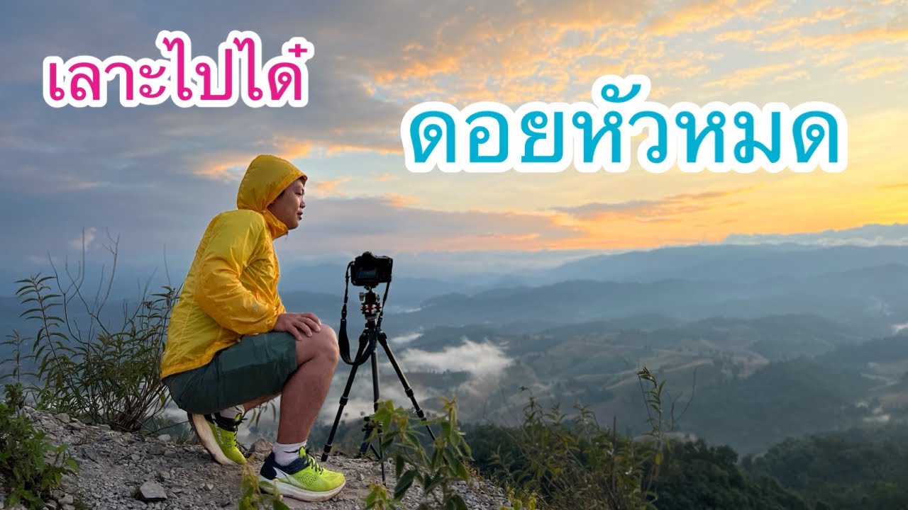
Doi Hua Mot is especially famous for morning sea mist. Visitors usually arrive before sunrise and walk up to the viewpoint while the sky is still dark. As the first light appears, mist spreads across the valleys and lower areas around Umphang. The view changes gradually from dark blue to pale orange and then to soft gold. On suitable mornings, the mist covers the land below like a white sea, while mountain ridges and the town of Umphang appear in the distance. This is the moment that makes Doi Hua Mot one of the must-visit viewpoints in Umphang.
The viewpoint also offers beautiful sunset scenery. In the late afternoon, the limestone slopes and grassland take on warm colours as the sunlight becomes softer. Visitors can see layered mountains, the open sky, and the quiet landscape of Umphang before evening falls. Sunset visits should be planned carefully because the walking path becomes dark quickly after the sun goes down. A flashlight or a fully charged phone is useful for safety on the return walk.
There are two main viewpoint access points at Doi Hua Mot. The first is around kilometre 9 on the Umphang-Ban Pa La Tha route. From this point, visitors walk uphill for about 20 minutes to reach the viewpoint. The second is around kilometre 10, where a left turn leads to a parking area and a shorter walk of about 5 minutes. Both points offer impressive views, but visitors can choose according to time, fitness, and weather conditions.
The plants on Doi Hua Mot are another important part of the experience. Because the mountain is open and limestone-based, visitors can see drought-tolerant plants and low-growing wildflowers more clearly than in dense forest. Cycads grow among the rocks, while wild impatiens and other seasonal flowers add colour during the rainy season. Visitors should enjoy these plants without picking or stepping on them, as the flowers and low vegetation are part of the mountain’s fragile natural character.
The best time to visit Doi Hua Mot is from the late rainy season to the cool season. During the late rainy season, the mountain is green and wildflowers may be in bloom. During the cool season, the air is fresh, the sky is often clearer, and sea mist is more likely in the morning. The area can be windy and cool before sunrise, so visitors should bring a light jacket or windbreaker. Shoes with good grip are recommended because the walking path may be damp from dew or rain.
Travel to Doi Hua Mot usually begins in Umphang town. From there, follow the Umphang-Ban Pa La Tha route for about 10 km to reach the viewpoint access areas. Travelers coming from Mae Sot must use Highway 1090 to reach Umphang, a mountain road of about 163 km. This route is famous for its many curves and requires careful driving. Drivers should check the vehicle, brakes, tires, fuel, and travel time before starting the journey.
Although Doi Hua Mot is close to Umphang town, early-morning travel still requires caution. The road can be dark, foggy, or damp, especially during the cool season or after rain. Visitors should drive slowly, use headlights, and park only in appropriate areas. At the viewpoint, it is important to stay on safe paths, avoid slippery rocks, and keep a safe distance from steep slopes, especially when visibility is limited by fog.
Doi Hua Mot fits well into a wider Umphang itinerary. Many travelers visit the viewpoint early in the morning, return to town for breakfast, and then continue to other attractions such as Pa La Tha Waterfall, Thi Lo Su Waterfall, or rafting on the Mae Klong River. This makes Doi Hua Mot a convenient and rewarding first stop for travelers who want to begin their day with sunrise and sea mist before exploring the larger natural landscapes of Umphang.
For photographers, Doi Hua Mot offers many strong compositions: silhouettes of visitors on the ridge, mist below the viewpoint, limestone rocks, cycads, wildflowers, sunrise colours, and panoramic views over Umphang. A wide-angle lens is useful for landscapes, while a medium lens can capture details of plants and mountain layers. Morning humidity may affect cameras and phones, so a lens cloth or waterproof pouch can be useful.
Families can visit Doi Hua Mot, but they should choose the viewpoint route carefully. The kilometre 10 access point involves a shorter walk and may be easier for visitors with limited walking ability. The kilometre 9 viewpoint requires a longer uphill walk of about 20 minutes. Children and elderly visitors should be accompanied closely, especially in the dark, after rain, or when the path is slippery.
Responsible travel is important at Doi Hua Mot. Visitors should not leave rubbish, pick wildflowers, damage plants, walk off fragile areas, or make excessive noise. All plastic bottles, food packaging, cups, and waste should be taken back down. The beauty of Doi Hua Mot depends on its clean and open landscape, and every visitor helps preserve that atmosphere by leaving no trace behind.
Doi Hua Mot is more than a viewpoint. It represents the natural identity of Umphang: limestone mountains, cool air, misty valleys, seasonal flowers, and wide views over one of the most remote districts of Tak Province. For travelers who want to experience Umphang beyond waterfalls and rafting, this mountain offers a quiet and beautiful beginning to the day. The short climb is rewarded with a memorable view of sea mist, sunrise, and the green limestone slopes that make Doi Hua Mot unique.
| Name | Doi Hua Mot |
| Location | Umphang Subdistrict, Umphang District, Tak Province |
| Address | Umphang-Ban Pa La Tha Route, Umphang District, Tak 63170 |
| Coordinates / Reference Point | Umphang-Ban Pa La Tha Route, viewpoint access around kilometre 9 and kilometre 10, about 10 km from Umphang town |
| Highlights | Limestone mountain range, morning sea mist, sunrise, sunset, green grassland, cycads, wild impatiens, and panoramic views of Umphang |
| History | A well-known natural viewpoint in Umphang District, featuring a long limestone mountain range and one of Tak Province’s popular sea-of-mist viewpoints. |
| Name Origin | The name refers to the open, bare-looking character of the mountain, where large trees are absent and only grass, low plants, cycads, and wildflowers grow among limestone rocks. |
| Distinctive Features | A limestone mountain range about 30 km long and about 2 km wide, with open slopes, no large trees, and wide views over misty valleys and surrounding mountains. |
| Travel Information | From Umphang town, follow the Umphang-Ban Pa La Tha route for about 10 km. The first viewpoint is around kilometre 9 with a 20-minute uphill walk. The second is around kilometre 10 with a left turn and about a 5-minute walk. Travelers reaching Umphang from Mae Sot use Highway 1090 for about 163 km. |
| Current Status | A natural viewpoint in Umphang District. Visitors should check weather and road conditions before visiting, especially before dawn or during the rainy season. |
| Open Days | Daily |
| Opening Hours | Best visited before sunrise in the early morning or in the late afternoon before sunset |
| Facilities | Parking areas near viewpoint access points, short walking trails, viewpoints, and restaurants/accommodations in Umphang town |
| Main Areas / Zones | 1. Kilometre 9 Viewpoint Access 2. 20-Minute Uphill Walking Trail 3. Kilometre 10 Viewpoint Access 4. Left-Turn Parking Area 5. 5-Minute Walking Trail 6. Sunrise and Sea-Mist Viewpoint 7. Sunset Viewpoint |
| Caretaker / Area Authority | Umphang Subdistrict Administrative Organization and local authorities in Umphang District |
| Main Contact Number | Umphang Subdistrict Administrative Organization Tel. 055-561416 Umphang Municipality Tel. 055-561613, 055-561018 |
| Official Website / Official Page | Umphang Subdistrict Administrative Organization website and Umphang Municipality website |
| Nearby Tourist Attractions | 1. Umphang Town, about 10 km 2. Pa La Tha Waterfall, about 17 km 3. Mae Klong River Rafting Area, about 10 km 4. Thi Lo Su Waterfall, about 47 km 5. Ban Pa La Tha, about 22 km |
| Nearby Restaurants | 1. Ban Kru Sun, Umphang, about 10 km, Tel. 055-561342, 087-8464501 2. Amo-Apa Cafe, Umphang, about 10 km, Tel. 085-7269727, 082-8828930 3. Krua Khon Ban Hao, Umphang, about 10 km, Tel. 055-561207, 080-0394631 4. Krua Pa Nee, Umphang, about 10 km, Tel. 089-6763721 5. Cheewa Doi, Umphang, about 10 km, Tel. 055-561176 |
| Nearby Accommodations | 1. Phudoi Campsite & Resort, about 10 km, Tel. 055-561049, 098-4561914 2. Thee Lor Su Riverside Resort, about 10 km, Tel. 089-8321455, 089-0165666, 055-809035 3. Umphangburi Resort, about 10 km, Tel. 055-561576, 063-9894555, 095-3608209 4. Umphang Hill Resort, about 10 km, Tel. 055-514341, 084-8129599 5. Ban Huai Nam Yen, about 10 km, Tel. 055-561093 |
Frequently Asked Questions (FAQ)
Q: Where is Doi Hua Mot located?
A: Doi Hua Mot is located along the Umphang-Ban Pa La Tha route in Umphang District, Tak Province, about 10 km from Umphang town.
Q: What is special about Doi Hua Mot?
A: It is known for its long limestone mountain range, morning sea mist, sunrise, sunset, green grassland, cycads, wild impatiens, and high views over Umphang.
Q: What is the best time to visit Doi Hua Mot?
A: Visitors should arrive before sunrise around 05.00-06.00 for sea mist and morning light, or visit in the late afternoon for sunset.
Q: How many viewpoints are there at Doi Hua Mot?
A: There are two main access points. The first is around kilometre 9 with a 20-minute uphill walk, and the second is around kilometre 10 with about a 5-minute walk.
Q: When is the best season for Doi Hua Mot?
A: The late rainy season and cool season are ideal. The mountain is green, wildflowers may bloom, and the chance of seeing morning mist is high.
Q: What should visitors prepare for Doi Hua Mot?
A: Shoes with good grip, a light jacket or windbreaker, flashlight, drinking water, camera, and careful driving are recommended, especially before dawn.
Q: What nearby places can be visited with Doi Hua Mot?
A: Nearby places include Pa La Tha Waterfall, Thi Lo Su Waterfall, Mae Klong River rafting routes, Ban Pa La Tha, and Umphang town.
![]() Category: ●Nature and Wildlife
Category: ●Nature and Wildlife
![]() Group: ●Mountain (Doi)
Group: ●Mountain (Doi)
Last Update : 1 MonthAgo
Doi Hua Mot Map
Gellery
Recommend


