
lovethailand home >North Travel Attractions >Lampang Travel Attractions > 50 Places to Visit in Lampang Northern Thailand
TL;DR: 50 Places to Visit in Lampang Northern Thailand, open Daily Opening Hours: 07:30 – 17:00.

50 Places to Visit in Lampang Northern Thailand
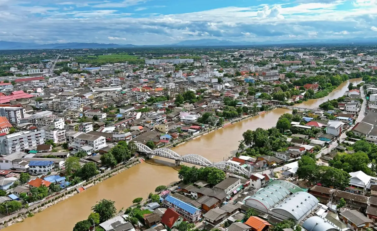
50 Places to Visit in Lampang: Must-See Attractions in Northern Thailand Lampang is one of Northern Thailand’s most distinctive travel destinations, combining a historic town along the Wang River, Lanna architecture, Burmese temples from the teak-concession era, traditional horse-drawn carriages that are still in service, a long-established ceramics industry, forested mountains, waterfalls, hot springs, and highland communities. If you have only 1 day, begin in Lampang Old Town with Kad Kong Ta, Wat Phra Kaew Don Tao Suchadaram, Wat Pong Sanuk, and a horse-carriage ride around the city. With 2–3 days, add Wat Phra That Lampang Luang, the Thai Elephant Conservation Center, and Chae Son National Park. Travelers with 4–5 days or more can extend their journey to Chae Hom, Mueang Pan, Ko Kha, Hang Chat, and the province’s outlying natural attractions for a more complete experience of Lampang’s history, culture, and landscapes.
Lampang Province lies in Upper Northern Thailand in a broad basin surrounded by mountains, with the Wang River flowing through the city before joining the Ping River basin. This geographical setting allowed Lampang to develop into an important center for settlement, agriculture, transportation, and trade between northern towns over many centuries. Although the city has expanded considerably, its historic districts still preserve temples, wooden houses, old commercial buildings, bridges, and long-established communities, making Lampang particularly rewarding for travelers who enjoy exploring slowly and understanding the stories behind a place.
Lampang’s historical roots are closely connected with Khelang Nakhon and the wider Lanna cultural world. Northern legends link the city with Queen Chamadevi and Hariphunchai, while religious and artistic evidence preserved in many local temples reflects the city’s development from the Lanna era through the period when Lampang became economically important because of the teak trade during the reign of King Rama V and the later Rattanakosin period.
The teak-concession era transformed Lampang dramatically. Logging companies and merchants from different backgrounds established operations in the province, particularly Burmese communities and people connected with trading networks in British colonial territories. This led to the construction of Burmese temples, wealthy merchants’ residences, and buildings combining Lanna, Burmese, and Western architectural influences. These layers of history can still be seen at places such as Wat Si Rong Mueang, Baan Sao Nak, and the historic buildings around Kad Kong Ta.
Lampang also has a transportation symbol unlike any other Thai province: the Lampang horse carriage. These carriages are not simply staged tourist attractions but part of the city’s living memory and are still used within the urban area. Riding through old temples, traditional commercial neighborhoods, and streets along the Wang River remains one of the best ways to experience the atmosphere of Lampang at a slower pace.
Religiously, Lampang contains several temples of national cultural importance. Wat Phra That Lampang Luang preserves an outstanding ancient Lanna temple layout and architectural ensemble. Wat Phra Kaew Don Tao Suchadaram is associated with the history of the Emerald Buddha. Wat Pong Sanuk demonstrates the strength of community-based heritage conservation, while Wat Chaloem Phra Kiat Phrachomklao Rachanuson has become one of the province’s most recognizable images, with white pagodas perched high on limestone peaks above Chae Hom District.
Lampang’s natural attractions are just as diverse as its cultural heritage. Chae Son National Park combines hot springs, waterfalls, forested mountains, and wellness-oriented attractions, while Mueang Pan and Chae Hom connect travelers with mountain routes, villages, and viewpoints suitable for overnight stays. Nature travelers can therefore make Lampang a destination in its own right rather than treating it only as a city stop.
Another important identity of Lampang is its ceramics industry. The province has deposits of kaolin clay and a long tradition of pottery production, eventually making the rooster bowl one of the symbols most strongly associated with Lampang. Today, visitors can explore learning centers, shops, craft spaces, and ceramic displays that reveal both local craftsmanship and the economic importance of pottery production.
Lampang’s food reflects both Northern Thai traditions and the cultural diversity of its communities. Visitors can find khao soi, gaeng hung lay, nam prik noom, sai ua, regional dishes, and local sweets, while Kad Kong Ta and community markets make it easy to sample several foods in one visit. In addition to ceramics, popular souvenirs include wooden products, handicrafts, locally woven textiles, and community-made goods from different districts of the province.
For trip planning, Lampang can be divided into several practical travel zones. Lampang City and the Wang River are best for the old town, temples, horse carriages, markets, and historic houses. Ko Kha is centered around Wat Phra That Lampang Luang, Hang Chat around the Thai Elephant Conservation Center, Chae Hom around Wat Chaloem Phra Kiat Phrachomklao Rachanuson, and Mueang Pan–Chae Son around mountains, hot springs, forests, and waterfalls. Organizing the trip by zone reduces unnecessary backtracking and allows more time to explore each area in depth.
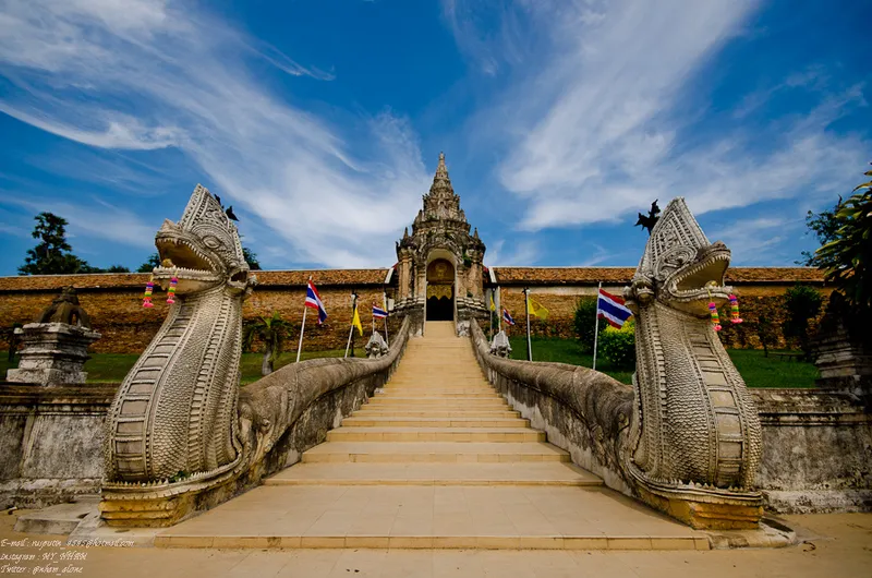
1. Wat Phra That Lampang Luang is located in Lampang Luang Subdistrict, Ko Kha District, approximately 18 km from Lampang city. It is one of the province’s most important spiritual landmarks and holds exceptional significance for Lanna history, religion, and architecture. It is also one of Northern Thailand’s ancient temples where the original traditional temple layout has been preserved remarkably well.
Highlights: Phra That Lampang Luang, Viharn Luang, Viharn Phra Phut, Viharn Nam Taem, the Khong Gate, naga staircase, the Phra Bat pavilion with its inverted image phenomenon, and a remarkably well-preserved traditional Lanna temple plan.
The temple stands on elevated ground, reached by a naga staircase leading to the ornate Khong Gate. Passing through the enclosing wall reveals a carefully arranged complex of religious structures following the traditional Lanna temple plan, including the main chedi, Viharn Luang, subsidiary viharns, and ceremonial spaces. Entering the courtyard therefore feels distinctly different from entering a modern Thai temple.
Phra That Lampang Luang is the spiritual center of the temple. Its graceful Lanna form makes it one of Lampang’s most revered sacred monuments. Around the chedi are several viharns preserving woodwork, mural paintings, Buddha images, and architectural details that illustrate the development of Lanna craftsmanship in the region.
Viharn Nam Taem deserves time for close observation because of its historic paintings and surviving architectural features. Viharn Luang, meanwhile, is a large traditional open-sided Lanna assembly hall that allows visitors to experience a form of sacred architecture dating from before enclosed concrete temple halls became widespread.
Another famous feature is the Phra Bat pavilion, where light from outside passes through a small opening into a dark interior and projects an inverted image of the chedi onto an interior surface. This optical phenomenon makes Wat Phra That Lampang Luang interesting not only for religious visitors but also for those interested in traditional architecture and the behavior of light.
The temple is suitable for visitors of all ages, especially those interested in history, Lanna art, photography, and Buddhist pilgrimage. It can easily be combined with other attractions in Ko Kha District before returning to Lampang city on the same day.
Open Days: Daily Opening Hours: 07:30 – 17:00
Getting There: From Lampang city, take the Lampang–Thoen road toward Ko Kha District, then follow signs into Lampang Luang Subdistrict. The distance is approximately 18 km. A private car or rental car is the most convenient option.

2. Kad Kong Ta Walking Street is located along Talat Kao Road beside the Wang River in Lampang city. It is both a historic district and a weekend walking street that clearly reflects Lampang’s past as an important commercial center. Historic buildings, local food, crafts, and everyday community life make Kad Kong Ta an essential stop on almost any Lampang itinerary.
Highlights: Weekend walking street, historic riverside buildings, Chinese, Burmese, Lanna, and Western architectural influences, local food, handmade crafts, traditional houses, and the atmosphere of an old commercial quarter.
The Northern Thai word “kad” means market, while the Kong Ta district historically developed around an important riverside landing. When the Wang River still functioned as a transportation route for goods, merchants from different ethnic communities settled here and built residences, shops, and warehouses, creating a commercial district with varied architectural styles along the street.
The charm of Kad Kong Ta lies in seeing history through real surviving buildings. Some houses combine Chinese and Western details, while others reveal Burmese and Lanna influences. This architectural diversity reflects Lampang society during the period when the city became an important trading and teak-business center.
On Saturday and Sunday evenings, the street becomes a lively walking street lined with Northern Thai food, desserts, ceramics, clothing, crafts, collectibles, and locally made products. It is an easy place to sample several local dishes and buy souvenirs during the same visit.
Travelers interested in photography should arrive slightly before the market becomes crowded to photograph the historic buildings in the softer evening light, then continue toward Ratsadaphisek Bridge or the Wang River. Once the street lights come on, the district takes on a completely different nighttime atmosphere.
Kad Kong Ta is suitable for families, couples, groups of friends, and food-focused travelers. It can easily be combined with Wat Pong Sanuk, Baan Sao Nak, Wat Phra Kaew Don Tao Suchadaram, and a horse-carriage ride around the old town.
Open Days: Saturday – Sunday Opening Hours: 17:00 – 22:00
Getting There: Kad Kong Ta is located on Talat Kao Road in Suan Dok Subdistrict, Mueang Lampang District. It can be reached by car, motorcycle, local transport, or horse carriage. During walking-street hours, it is better to park outside the central market area and continue on foot.
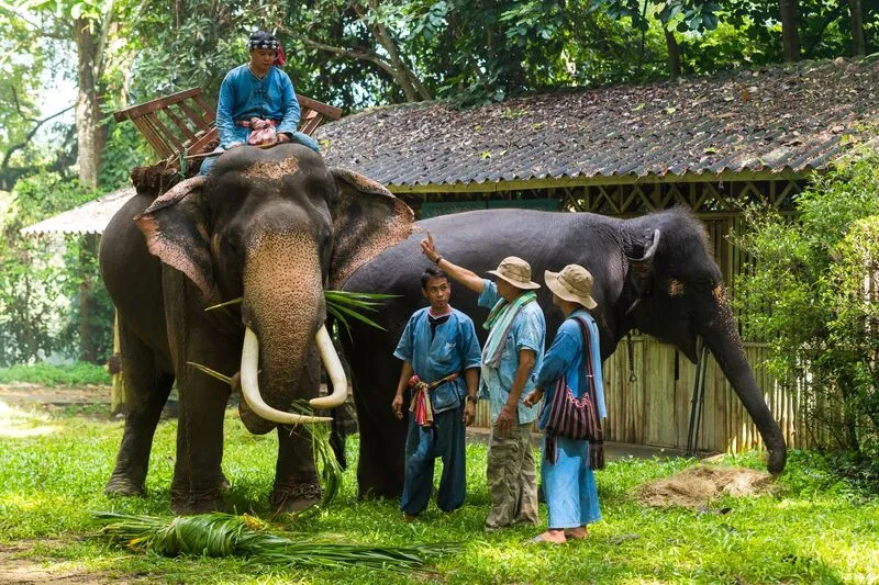
3. Thai Elephant Conservation Center is located at Thung Kwian, Wiang Tan Subdistrict, Hang Chat District, beside Highway 11. It is one of Thailand’s important centers for learning about elephants, with roles in elephant care, conservation, mahout knowledge, and understanding the long relationship between elephants and forests.
Highlights: Learning about Thai elephants, elephant care facilities, elephant hospital, the Thung Kwian forest area, elephant observation activities, and the historic relationship between elephants, people, and Thailand’s forestry industry.
The center developed from earlier systems used to train and care for working elephants in the forestry sector. When the role of logging elephants declined following changes in forestry policy, many elephants required long-term care and appropriate welfare systems. Thung Kwian therefore became an important place in the transition from working elephants toward conservation, veterinary care, and public education.
Visitors can learn about elephant behavior, health care, relationships between elephants and mahouts, and the role elephants once played in the economic history of Northern Thailand. A visit therefore has a strong educational dimension beyond simply viewing elephants as entertainment.
The forested grounds are spacious and shaded, making the center suitable for families and children who can learn about both animals and nature. Visitors should follow staff instructions, avoid approaching elephants outside designated areas, and refrain from behavior that could disturb the animals.
For travelers interested in Lampang history, the center also connects directly with the province’s teak-concession period and the former use of elephants to haul logs, an industry that played a major role in Lampang’s economic development in the late 19th and early 20th centuries.
The center lies on the Lampang–Lamphun route, making it easy to combine with attractions in Hang Chat District or to use as a stop between Lampang and Chiang Mai.
Open Days: Daily Opening Hours: 08:30 – 15:30
Getting There: From Lampang city, take Highway 11 toward Hang Chat and Lamphun. The center is located in the Thung Kwian Forest Plantation area, approximately 24 km from the city. Traveling by private car is the most convenient option.

4. Wat Chaloem Phra Kiat Phrachomklao Rachanuson is located at Ban Thung Thong, Wichet Nakhon Subdistrict, Chae Hom District, and has become one of the most recognizable images of Lampang tourism. Its small white pagodas are scattered across ridges and limestone pinnacles high above the surrounding plain.
Highlights: White pagodas on limestone peaks, elevated viewpoints over Chae Hom District, the Buddha footprint, mountain access route, and an extraordinary landscape where Buddhist faith and rugged natural scenery meet.
The site is also widely known as Wat Phra Phutthabat Pu Pha Daeng and may also be referred to as Wat Phutthabat Sutthawat. The landscape consists of steep limestone mountains that were gradually developed into a religious site, with white pagodas constructed on peaks, ridges, and rocky outcrops.
The famous impression of pagodas seemingly floating above the mountains comes from their construction at different elevations. Viewed from below or from the designated viewpoints, the white structures line up dramatically against the mountain ridges and sky, creating a scene unlike that of most Thai temples.
Reaching the upper section requires traveling from the base of the mountain and then continuing along the designated route, with some sections involving stair climbing. Visitors should wear secure footwear, carry drinking water, and consider their physical condition, particularly elderly travelers or anyone with limited mobility.
Morning is generally the best time to climb because temperatures are lower and visibility is often better. Mist and low clouds can create a different atmosphere, but visitors should avoid climbing during heavy rain or whenever trail conditions are unsafe.
The temple can be combined with other attractions in Chae Hom and Chae Son National Park on a 1–2 day itinerary, allowing travelers to experience a mountain temple, hot springs, and natural attractions within the same travel zone.
Open Days: Daily Opening Hours: 07:30 – 16:00
Getting There: From Lampang city, travel toward Chae Hom District and continue to Ban Thung Thong, Wichet Nakhon Subdistrict, following signs for Wat Chaloem Phra Kiat Phrachomklao Rachanuson. At the mountain base, use the transport and access system provided for the upper temple area.
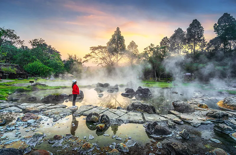
5. Chae Son National Park lies in Mueang Pan District and covers mountainous terrain in northern Lampang. It is one of the province’s most important destinations for nature and wellness tourism, combining hot springs, Chae Son Waterfall, forested mountains, nature trails, and recreational areas in one location.
Highlights: Chae Son Hot Springs, Chae Son Waterfall, natural mineral-water streams, mountain forest, nature trails, and the cool climate of the Mueang Pan area.
The Chae Son Hot Springs are the park’s best-known feature. Naturally heated water rises from below ground and flows across rocky ground, producing clouds of steam that are particularly visible in the cool morning air. This atmosphere distinguishes Chae Son from national parks focused primarily on forest and waterfalls.
The hot-spring area is associated with relaxation and wellness activities, while Chae Son Waterfall lies in a shaded forest where water descends through several levels. Visitors can therefore spend an entire day in the park without needing to travel between distant attractions.
Winter is the best season for enjoying the hot springs because cooler air makes the steam more visible, while the rainy season brings greener forest and stronger waterfall flow. Travelers should check park announcements concerning trails and waterfall areas before visiting during periods of heavy rain.
The park is suitable for families, couples, groups of friends, and older travelers looking for a relaxing natural environment. Visitors planning to walk nature trails or travel to more remote areas should prepare footwear and equipment appropriate to the terrain.
With several days available, travelers can continue to Ban Pa Miang, Doi Kio Fin, Mae Pan Waterfall, and communities around Mueang Pan, making the Chae Son area better suited to an overnight stay than a rushed day trip.
Open Days: Daily Opening Hours: 08:00 – 18:00
Getting There: From Lampang city, travel toward Mueang Pan District and Chae Son Subdistrict, following the road to Chae Son National Park headquarters. The final section is mountainous, so the vehicle should be in good condition and sufficient travel time should be allowed.

6. Wat Phra Kaew Don Tao Suchadaram is located in Wiang Nuea Subdistrict, Mueang Lampang District. This ancient temple is extremely important to the Buddhist history of Northern Thailand and is associated with the history of the Emerald Buddha, which was once enshrined in Lampang for an extended period.
Highlights: The history of the Emerald Buddha, Phra Borommathat Don Tao, Burmese-style mondop, Lanna viharns, a mixture of Lanna and Burmese art, and a museum of Lanna cultural heritage.
The temple’s history is associated with local stories involving an emerald object and the Northern Thai term “mak tao,” which became part of the temple’s name. This tradition connects Wat Phra Kaew Don Tao with the history of the Emerald Buddha, one of Thailand’s most revered Buddha images.
Phra Borommathat Don Tao forms the spiritual center of the complex, while several buildings reflect artistic influences from different periods. The Burmese-style mondop is especially significant because it illustrates Lampang’s close connections with Burmese communities during the prosperous teak-trade era.
The coexistence of Lanna and Burmese elements makes the temple particularly interesting for travelers studying cultural exchange. Lampang was influenced not only by the central Lanna world but also by networks of Burmese workers, merchants, and wealthy patrons.
The temple grounds are relatively extensive, so visitors should take time to explore the chedi, viharns, mondop, and exhibition areas rather than stopping only for exterior photographs. The interior details reveal much about the historical development of Lampang.
The temple lies in the old town area and can easily be combined with Baan Sao Nak, Wat Pong Sanuk, Kad Kong Ta, and a Lampang horse-carriage ride in the same day.
Open Days: Daily Opening Hours: 06:00 – 18:00
Getting There: The temple is in Wiang Nuea Subdistrict, Mueang Lampang District, not far from Kad Kong Ta and the Wang River. It is easily reached by car, motorcycle, local transport, or horse carriage.
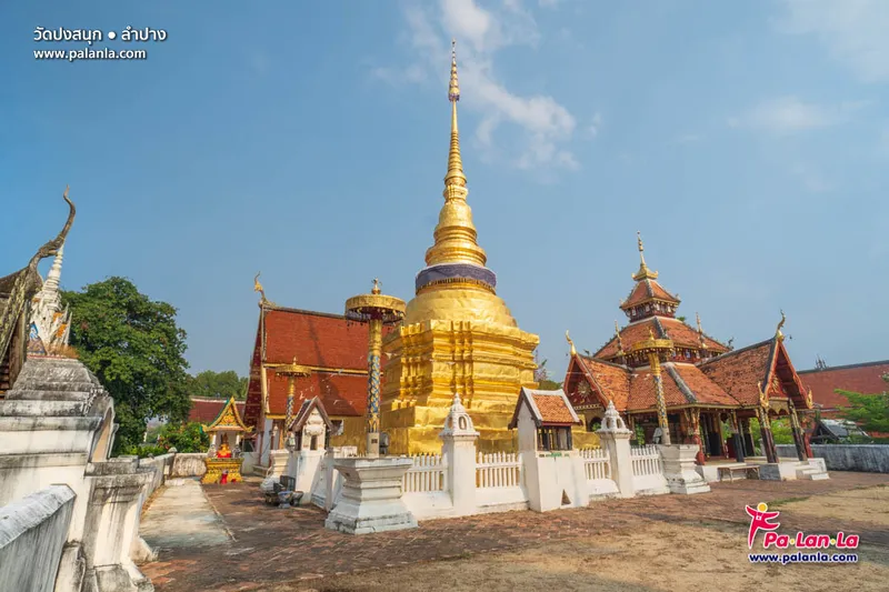
7. Wat Pong Sanuk Nuea is located in Wiang Nuea Subdistrict, Mueang Lampang District. This ancient temple is important for its history, artistic heritage, and community-based conservation. Its most distinctive structure is Viharn Phra Chao Phan Ong, an open-sided cruciform wooden pavilion that represents a rare form of Lanna architecture.
Highlights: The more-than-120-year-old Viharn Phra Chao Phan Ong, cruciform open hall, wooden Buddha images, pha bot paintings, old scripture chests, chedi, and the story of community-led heritage conservation.
The name Wat Pong Sanuk has long been part of Lampang’s local memory, with traditions connecting the site to the establishment of Khelang Nakhon. The temple is therefore more than a place of worship; it is also part of the city’s foundation narratives.
Viharn Phra Chao Phan Ong is a raised wooden structure open on four sides with a tiered roof that demonstrates the skill of Lanna craftsmen. Numerous artistic details inside and around the pavilion reward slow observation, especially for visitors interested in historic architecture.
The temple is also important because of its conservation process, in which local residents participated in protecting, restoring, and caring for their cultural heritage. Wat Pong Sanuk is therefore a strong example of conservation that keeps historic monuments connected to the life of the surrounding community.
The complex also preserves wooden Buddha images, pha bot paintings, scripture chests, and other religious objects, allowing visitors to see the relationships between craftsmanship, Buddhist manuscripts, religious practice, and Lanna community life.
Wat Pong Sanuk can be combined with Wat Phra Kaew Don Tao Suchadaram, Baan Sao Nak, and Kad Kong Ta within half a day, making it ideal for travelers focusing on Lampang Old Town without driving outside the city.
Open Days: Daily Opening Hours: 08:00 – 17:00
Getting There: The temple is located in Wiang Nuea Subdistrict, close to the historic district and the Wang River. It can be reached by car, motorcycle, local transport, or included in a horse-carriage sightseeing route.
Map (GPS):Open Google Maps – Wat Pong Sanuk Nuea
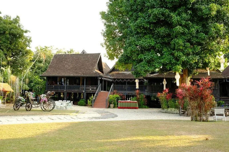
8. Baan Sao Nak is located at 86 Pa Mai Road in Mueang Lampang District. This historic teak house is famous for its 116 teak pillars. The Northern Thai name “Sao Nak” means “many pillars,” and the house has become one of Lampang’s best-known symbols of the teak-economy era.
Highlights: 116 teak pillars, Burmese-Lanna architectural influences, antique furniture and household objects, the history of wealthy families during the teak era, and an old saraphi tree within the grounds.
The house was built in 1895 by Mong Chan Ong, ancestor of the Chandraviroj family, during the period when the teak industry made Lampang one of Northern Thailand’s major economic centers. The extensive use of teak reflects both the owner’s wealth and the economic environment of that era.
The architecture combines Lanna traditions with Burmese influences in the timber structure, spatial arrangement, and decorative details. The complex was designed as a large group of interconnected residential spaces suitable for an affluent household and its activities.
Inside are displays of furniture, household objects, and antiques that help visitors imagine the lifestyle of a wealthy Lampang family from the late 19th to the early 20th century.
Baan Sao Nak is an excellent photography stop for travelers who enjoy timber architecture and historic houses, but its historical context is equally important. The residence helps explain why Lampang contains so many Burmese temples, wealthy merchants’ houses, and multicultural influences compared with many other northern cities.
The house can be combined conveniently with Wat Phra Kaew Don Tao Suchadaram, Wat Pong Sanuk, and Kad Kong Ta, and it also fits naturally into a horse-carriage sightseeing route around Lampang.
Open Days: Daily Opening Hours: 09:00 – 17:00
Getting There: Baan Sao Nak is on Pa Mai Road in central Lampang and can be reached by car, local songthaew, taxi, or horse carriage.
Map (GPS):Open Google Maps – Baan Sao Nak

9. Lampang Horse Carriages are one of the symbols that distinguish Lampang from other Thai cities. Horse-drawn carriages continue to operate within the urban area, giving visitors both a sightseeing activity and a slower way to explore the historic city.
Highlights: Horse-carriage rides through the old town, the sound of horses’ hooves on city streets, routes past temples and historic buildings, a nostalgic experience of old Lampang, and a provincial symbol that remains part of everyday urban life.
The history of horse carriages in Lampang is closely linked to the period when the city became a teak-concession center and foreigners arrived to conduct business. Motor vehicles were not yet widespread, so horse-drawn carriages were used by government officials, merchants, and wealthy residents before gradually losing their transportation role after automobiles became common.
What makes Lampang unusual is that the horse carriage did not disappear. Instead, the tradition was preserved and became part of the city’s identity. Visitors can still hear hoofbeats and see horse carriages moving alongside modern vehicles, a sight rarely encountered elsewhere in Thailand.
Sightseeing routes generally pass through the historic district, important temples, old buildings, and the Wang River area, allowing passengers to notice urban details that are easily missed when traveling quickly by car.
Horse-carriage rides are suitable for families, couples, international visitors, and older travelers who want to explore without extensive walking. Morning and evening rides are more comfortable than midday trips, and travelers should support operators who pay proper attention to horse welfare.
A horse-carriage ride can be combined with Baan Sao Nak, Kad Kong Ta, Wat Pong Sanuk, and Wat Phra Kaew Don Tao Suchadaram, creating an excellent introduction to Lampang’s historic atmosphere and local identity within a few hours.
Open Days: Daily Opening Hours: 06:00 – 23:00
Getting There: Horse-carriage service points are located within Lampang city. Visitors can travel to the main service areas and choose a route or riding duration according to the services available.

10. Ban Suan Ceramics is a cultural and craft attraction in Lampang that reflects the identity of Thailand’s ceramic city through celadon and pottery. The site has the atmosphere of a garden residence combined with an art gallery, with ceramics incorporated into both interior and exterior decoration.
Highlights: Celadon, Lampang ceramics, a shaded garden-house atmosphere, art-display spaces, ceramic household products and decorative pieces, and stories connected with local craftsmanship.
Lampang is famous for ceramics because of its kaolin resources, skilled craftspeople, and long development of the pottery industry. Ban Suan Ceramics connects the industrial image of ceramic production with art and design.
The property is arranged like a garden house where visitors can explore at a relaxed pace. Walls, interior spaces, and decorative corners incorporate celadon products, demonstrating that ceramics are not limited to bowls, cups, and containers but can also become part of architecture and interior decoration.
Visitors can see tableware, vases, decorative objects, and various forms of celadon, helping them understand differences in surface texture, glaze color, shape, and craftsmanship.
The site is suitable for travelers interested in crafts, art, design, and souvenirs, particularly those who want to understand why ceramics have become one of Lampang’s most important economic and cultural identities.
Because visits should be arranged with the site in advance, it is better treated as a planned stop rather than an unannounced visit. It can be combined with attractions in Lampang city and other local craft destinations.
Getting There: Ban Suan Ceramics is in Pong Saen Thong Subdistrict, Mueang Lampang District. A private car is recommended, and visitors should contact the site in advance to confirm access.
Map (GPS):Open Google Maps – Ban Suan Ceramics
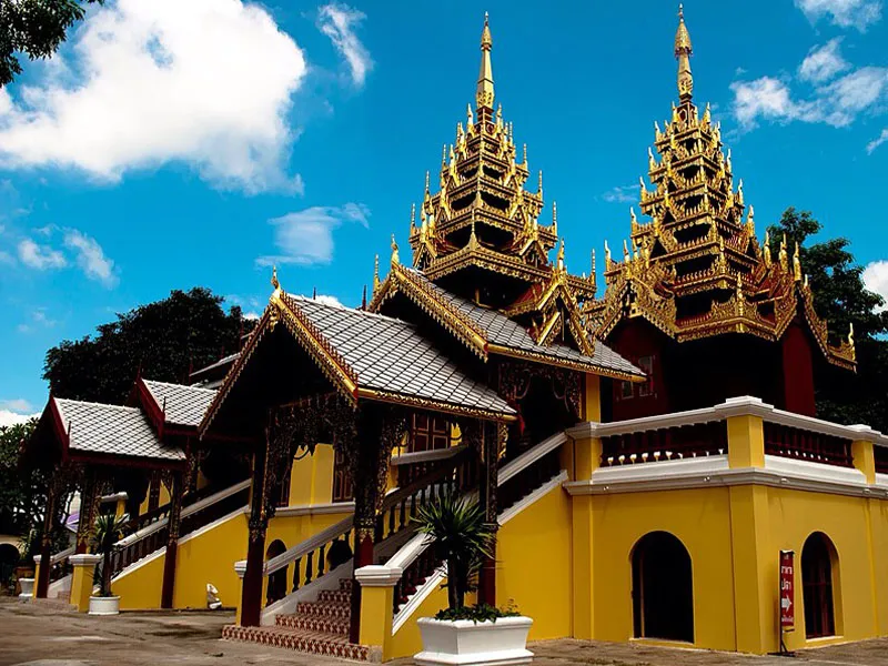
11. Wat Si Chum is located in Mueang Lampang District and is one of Thailand’s most important Burmese-style temples. It is also a major surviving landmark from the period when Lampang prospered through the forestry industry. The temple was established in 1890 by U Yo, a wealthy Burmese merchant involved in the teak business during the reign of King Rama V.
Highlights: Burmese and Lanna architecture, wooden viharn, carved floral patterns, layered roofs, Burmese-style spires, and the history of Lampang’s Burmese community during the teak-concession era.
In the late 19th century, Lampang was an important center of Northern Thailand’s forestry industry. Burmese merchants, wealthy patrons, and workers settled in the city in considerable numbers. Wealth generated by the teak trade led to the construction of several Burmese temples, making Wat Si Chum both a religious monument and evidence of Lampang’s economic and social structure during that period.
The temple’s architecture differs noticeably from conventional Lanna temples. The viharn displays detailed Burmese woodwork and decoration, while the layered roof and pointed elements emphasize vertical form. Delicate carved floral motifs further demonstrate the craftsmanship of the artisans involved.
Visitors should take time to observe the columns, ceiling, gables, wood carving, and decorative details. These smaller features help explain the differences between Burmese and Lanna artistic traditions more clearly than a quick exterior view.
Wat Si Chum is particularly suitable for travelers interested in history, architecture, woodwork, and the stories of migrant communities in Northern Thailand. It can be combined with other historic sites in Lampang city within the same day.
Visitors should dress respectfully because the temple remains an active place of worship and should avoid touching historic woodwork or fragile architectural elements.
Open Days: Daily Opening Hours: 06:00 – 18:00
Getting There: Wat Si Chum is located near Thipphawan Road in Mueang Lampang District. It is accessible by car, motorcycle, local transport, or as part of a Burmese-temple route around Lampang.
Map (GPS):Open Google Maps – Wat Si Chum

12. Mae Pan Waterfall is located in Mueang Pan Subdistrict, Mueang Pan District, within the area managed by Chae Son National Park. It is a relatively small waterfall with a shaded and peaceful forest atmosphere and is fairly easy to reach, making it suitable for travelers who want a natural retreat without a long trek.
Highlights: Forest waterfall, quiet surroundings, short walking approach, mountain forest of Mueang Pan, and easy connection with the Chae Son National Park travel route.
The appeal of Mae Pan Waterfall lies less in great height or scale than in the natural character of the stream flowing across rocks beneath a canopy of trees. The sound of water and cool forest air create an environment well suited to slow, relaxed travel.
From Ban Pang Ai, a concrete road continues approximately 2 km toward the waterfall area, followed by a walk of about 300 meters. The approach is therefore manageable for most visitors in normal physical condition.
The rainy season through early winter is when the surrounding vegetation is at its greenest and the waterfall carries more water. However, the trail and rocks can become slippery, so footwear with good grip is recommended and swimming should be avoided where the current is strong.
The waterfall is suitable for families, groups of friends, and travelers who enjoy small-scale natural attractions with a quiet atmosphere. It should not be approached expecting the facilities or activities of a large commercial tourist destination.
Mae Pan Waterfall can be combined with Chae Son National Park, Doi Kio Fin, Ban Pa Miang, and other attractions in Mueang Pan, making this area suitable for at least one full day of exploration.
Open Days: Daily Opening Hours: 08:00 – 18:00
Getting There: From Mueang Pan town, travel toward Ban Pang Ai. Continue approximately 2 km along the concrete access road and walk another 300 meters to the waterfall.
Map (GPS):Open Google Maps – Mae Pan Waterfall

13. Nakhon Lampang Railway Station is located on Rot Fai Road in Sop Tui Subdistrict, Mueang Lampang District. It serves as the province’s principal railway station and is also a historic building marking an important stage in the expansion of Thailand’s Northern Railway into Lampang.
Highlights: Two-story historic station building, arched lower level, timber structure, carved balcony details, red gabled roof, the history of the Northern Railway, and the growth of Sop Tui following the arrival of rail transport.
The station first received passenger trains on April 1, 1916, during the reign of King Rama VI. It once served as an important northern terminus before railway construction continued through mountainous terrain and Khun Tan Tunnel toward Chiang Mai.
The arrival of the railway significantly changed Lampang’s economy. Sop Tui, previously an outer area of the city, developed into a commercial and transportation district, while goods, passengers, and workers could travel more efficiently between Bangkok and Lampang.
The station building combines Western architectural elements with local details. Arches on the lower level, timber construction above, balconies, and the gabled roof give the station a distinctive appearance and make it an attractive photography location.
The station remains fully operational, so visitors can observe passenger trains, travelers, and the atmosphere of a living railway station rather than a building frozen as a museum. Visitors should remain cautious around platforms and avoid interfering with railway operations.
The station can be combined conveniently with Wat Si Chum and the Sop Tui district, making it especially interesting for travelers studying transportation history and Lampang’s urban development in the early 20th century.
Getting There: The station is on Rot Fai Road, Sop Tui Subdistrict. It can be reached from central Lampang by car, motorcycle, local transport, or directly by train.
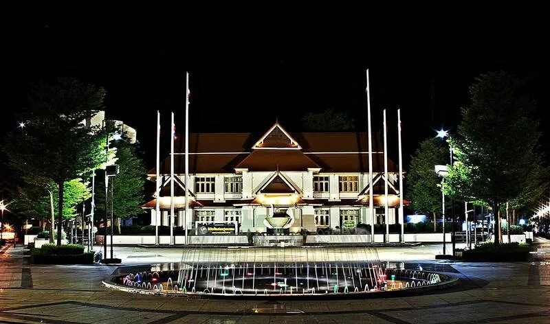
14. Hor Pum Lakhon Museum is housed in the former Lampang municipal office building and serves as a learning center presenting the story of Lampang through its urban history, people, economy, lifestyles, and changing social development.
Highlights: Lampang history exhibitions, Khelang Nakhon, community life, the Wang River, horse carriages, the teak trade, railway history, and the historic former municipal office building itself.
The name “Hor Pum Lakhon” refers to a place that records the story of “Lakhon,” an old local name associated with Lampang. The museum therefore works well as a starting point for travelers who want to understand the city before exploring its temples, old houses, bridges, and historic neighborhoods.
The exhibitions connect several periods of the city’s past, including legends and the history of Khelang Nakhon, development along the Wang River, the teak-concession era, migration of different ethnic groups, and urban growth after the arrival of the railway.
The museum is suitable for families, students, and history enthusiasts because it adds context to many of Lampang’s attractions. Understanding the teak era, for example, makes later visits to Burmese temples and Baan Sao Nak much more meaningful.
The former municipal building is itself part of Lampang’s history, so visitors should observe both the exhibitions and the architecture rather than viewing the museum simply as an indoor display space.
The museum can be combined with Kad Kong Ta, the Wang River area, Lampang horse carriages, and major city temples, making it a useful first stop for an old-town itinerary.
Getting There: Hor Pum Lakhon Museum is located in central Lampang in the former municipal office building. It is accessible by car, motorcycle, local transport, or as part of an old-town walking route.
Map (GPS):Open Google Maps – Hor Pum Lakhon Museum

15. Doi Kio Fin lies within Chae Son National Park along the mountain boundary between Lampang and Chiang Mai. At approximately 1,517 meters above sea level, it is a panoramic viewpoint ideal for cool-weather travel, sunrise, mountain scenery, and occasional seas of mist.
Highlights: Sunrise viewpoint, sea of mist, elevation of approximately 1,517 meters, broad mountain panoramas, cold weather, montane forest, and the route linking Ban Pa Miang with Chae Son National Park.
Winter is when Doi Kio Fin is most impressive. Early mornings can be very cold, and on suitable days a sea of mist covers the valleys below. As the sun rises, the morning light gradually reaches the mountain ridges, creating one of Lampang’s most rewarding natural photography locations.
A sea of mist is a natural phenomenon dependent on humidity, temperature, and wind, so it cannot be guaranteed every day. Travelers should appreciate the mountain environment and highland forest as part of the experience rather than visiting only for the mist.
The road to the viewpoint is mountainous, with curves and some steep sections. Travelers should check their vehicle, brakes, and weather conditions before setting out, particularly during rain or heavy fog when visibility can be reduced.
Warm clothing is recommended even during some periods outside the main winter season because temperatures at this elevation can be considerably lower than on the plains, especially before sunrise and after sunset.
Doi Kio Fin can be combined with Ban Pa Miang, Lan Dok Siao Blooming Field, and Chae Son National Park. Staying overnight in the Mueang Pan area avoids the need to rush up and down mountain roads in a single day.
Open Days: Daily Opening Hours: 06:00 – 18:00
Getting There: From Chae Son National Park or Mueang Pan, follow the mountain road toward Ban Pa Miang and the Chiang Mai provincial boundary before continuing to the Doi Kio Fin viewpoint. A vehicle in good mechanical condition is recommended.
Map (GPS):Open Google Maps – Doi Kio Fin

16. Lan Dok Siao Blooming Field is located around Ban Pa Miang in Chae Son Subdistrict, Mueang Pan District. It is known for naturally blooming dok siao, or wild bauhinia, during the transition from late winter into early summer, when large numbers of pale white flowers appear across the mountain landscape.
Highlights: Seasonal white dok siao blossoms, Ban Pa Miang mountain forest, cool weather, community routes through the valley, and convenient connection with Doi Kio Fin and Chae Son National Park.
The flowers are generally at their most notable from late January into February, although the actual blooming period varies according to temperature, rainfall, and annual weather conditions. Travelers should check the flowering situation before making a special journey.
Dok siao is a wild tree with delicate pale flowers. When many trees bloom at once along the mountain slopes, the forest takes on a completely different appearance from other times of year.
The area is not only about flowers. It is also connected with Ban Pa Miang, a mountain community where travelers who stay overnight can experience cool weather, local food, and valley life more fully than visitors who arrive only to take photographs and leave.
Visitors should not pick flowers, leave marked paths, or trample plants around the trees. Enjoying seasonal wildflowers responsibly is essential to preserving the site for future flowering seasons.
Lan Dok Siao can be combined with Doi Kio Fin, Ban Pa Miang, and Chae Son National Park and works particularly well as part of a 2-day, 1-night winter itinerary in Mueang Pan.
Open Days: Seasonal, according to the dok siao flowering period Opening Hours: Daytime visits are recommended according to road conditions and local announcements.
Getting There: From Chae Son National Park, follow the mountain road toward Ban Pa Miang, Chae Son Subdistrict, Mueang Pan District. Check road conditions and the current flowering status before traveling.
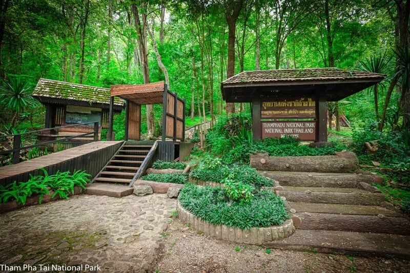
17. Tham Pha Thai National Park is a large forest area in Lampang covering parts of Ngao, Mueang Lampang, Mae Moh, and Chae Hom districts. The park covers approximately 758,750 rai and contains complex mountain ranges, mixed deciduous forest, dry dipterocarp forest, dry evergreen forest, limestone caves, waterfalls, and important watershed areas.
Highlights: Tham Pha Thai Cave, limestone mountains, cave systems, Lom Phu Khiao, watershed forest, biodiversity, and numerous natural attractions spread throughout the national park.
The park’s terrain is highly varied. Some peaks rise more than 1,000 meters above sea level, while the forests form headwaters feeding both the Wang and Ngao river systems, giving the protected area ecological importance at the provincial level.
Tham Pha Thai is one of the park’s principal attractions. The limestone cave contains chambers, passages, stalactites, stalagmites, and other geological formations, making it particularly interesting for visitors who want to understand karst landscapes and cave formation.
The park also connects with Lom Phu Khiao, waterfalls, and several other natural attractions. Visitors should plan by zone rather than trying to see everything in a single day because the distances between sites can be considerable.
Anyone entering caves or hiking nature trails should wear appropriate footwear, carry drinking water, and follow ranger instructions, particularly during the rainy season when water levels and trail conditions can change.
The park is suitable for nature lovers, geology enthusiasts, photographers, and families interested in forests and caves. It combines particularly well with Lom Phu Khiao and other natural attractions in Ngao District.
Open Days: Daily Opening Hours: 08:30 – 16:30
Getting There: The park’s main access area is in Ngao District. From Lampang city, travel by private car toward Ngao and follow signs to the national park and the specific attraction you plan to visit.

18. Lom Phu Khiao is located within Tham Pha Thai National Park in Ban On Subdistrict, Ngao District. This natural blue-green pool lies among limestone mountains and occupies a large sinkhole, creating one of Lampang’s most unusual and visually striking natural landscapes.
Highlights: Blue-green natural pool, limestone sinkhole, deep still water, surrounding forest, and a geological landscape very different from Lampang’s more familiar cultural attractions.
Lom Phu Khiao formed in limestone terrain through processes of rock dissolution and collapse, creating a deep depression where groundwater and natural runoff accumulated. The pool’s distinctive color changes according to light, depth, and local environmental conditions.
The intensity of the water can vary with the sky and angle of sunlight, sometimes appearing dark green and at other times blue-green. Viewed from above, the pool stands out dramatically against the surrounding forest and limestone cliffs.
Although the water may appear calm and clear, the pool is deep and is not intended for swimming. Visitors should remain within designated viewing areas and must not climb down cliffs or attempt to approach the water from unauthorized areas.
Midday generally provides stronger light for seeing the water’s color. After rain, visitors should be especially careful of slippery paths and check access conditions because the site lies within forested mountain terrain.
Lom Phu Khiao can be combined with Tham Pha Thai National Park and other natural attractions in Ngao District as a full-day excursion from Lampang city.
Open Days: Daily Opening Hours: 08:30 – 17:30
Getting There: From Ngao District, travel toward Ban On Subdistrict and enter the Tham Pha Thai National Park area. From Ban On community, the route to Lom Phu Khiao is approximately 6 km. Road conditions should be checked before traveling in the rainy season.
Map (GPS):Open Google Maps – Lom Phu Khiao

19. Kiu Lom Dam is an important dam on the Wang River in Lampang, serving irrigation and water-management functions while also supporting tourism. The reservoir above the dam forms a broad lake surrounded by mountains, forest, and cliffs, creating opportunities for relaxation and boat trips.
Highlights: Reservoir scenery, Wang River, mountains around the lake, raft and boat trips, natural landscapes, and connection with Ban Samphao Thong.
Kiu Lom Dam plays an important role in storing water and supporting irrigation throughout the Wang River basin. At the same time, the reservoir created after construction formed a new landscape suitable for water-based tourism.
One of the most enjoyable experiences is taking a raft or boat trip across the reservoir, which provides mountain and cliff views from water level. The atmosphere is very different from viewing the landscape only from shore because travelers can reach quieter interior areas of the reservoir.
Travelers interested in rafting should allow at least half a day if they want to enjoy the scenery without rushing and should reserve with a local operator in advance, especially on weekends or during peak travel periods.
Weather directly affects activities on the reservoir. During heavy rain, strong winds, or official warnings, visitors should postpone water activities according to advice from operators and local authorities.
Kiu Lom Dam is suitable for families, groups of friends, and travelers seeking a slow-paced nature experience. It can be combined with Samphao Thong rafting and other attractions in the Chae Hom area.
Getting There: From Lampang city, travel toward Ban Laeng Subdistrict and the Kiu Lom Dam area. Travelers planning to raft or travel deeper into the reservoir should contact an operator in advance to confirm the boarding point.
Map (GPS):Open Google Maps – Kiu Lom Dam

20. Samphao Thong Rafting is based around Ban Samphao Thong in Ban Sa Subdistrict, Chae Hom District. It offers a relaxing way to explore the water above Kiu Lom Dam while surrounded by mountains, forest, and lake scenery.
Highlights: Raft trips above Kiu Lom Dam, mountain views around the reservoir, peaceful atmosphere, lakeside community, half-day or full-day relaxation, and nature viewing from the middle of the water.
As the raft leaves the shore, the landscape gradually changes from community surroundings to broad open water and mountain ridges. Travelers see sections of the reservoir that cannot be appreciated from roads or the dam alone.
The attraction is not about speed or adventure sports but about spending extended time in nature, listening to wind and water while the forested mountains slowly change perspective as the raft moves.
Services may range from shorter trips to journeys lasting several hours depending on the raft and operator. Travelers should confirm duration, meals, stopping points, and safety equipment before departure.
Families traveling with children or elderly passengers should check boarding arrangements and life jackets in advance. During the rainy season, weather and water levels require particular attention.
Samphao Thong rafting can be combined with Kiu Lom Dam and attractions around Chae Hom. Allow at least half a day to a full day so that the experience does not become rushed.
Open Days: Daily by advance reservation Opening Hours: Depending on operator schedules, weather conditions, and advance bookings.
Getting There: Travel to Ban Samphao Thong, Ban Sa Subdistrict, Chae Hom District. Contact the raft operator in advance to confirm the meeting point, boarding location, departure time, and weather conditions.
Map (GPS):Open Google Maps – Samphao Thong Rafting

21. Wat Mon Phaya Chae, also known as Wat Phra That Mon Phaya Chae, is located in Phichai Subdistrict, Mueang Lampang District. This hilltop temple combines Buddhist faith with nature, with a sacred chedi on elevated ground and broad views over Lampang city and the surrounding mountain ranges.
Highlights: Phra That Mon Phaya Chae, viewpoint over Lampang city, hillside approach, peaceful surroundings, forest around the temple, and connection with Mon Phaya Chae Forest Park.
The temple’s appeal comes partly from its hilltop location. As visitors climb toward the chedi, views gradually open across Lampang city, surrounding communities, roads, and the mountains enclosing the Lampang basin.
The temple area is generally peaceful and suits travelers looking for a quieter alternative to the busy old-town districts. Along the approach, visitors encounter forested surroundings and slightly cooler air than on the plain below.
The chedi is the spiritual focus of the temple and has long-standing significance to local communities. The site should therefore be appreciated not only as a viewpoint but also as an active religious and cultural place.
Morning and late afternoon are the most comfortable times to climb because temperatures are lower and light conditions are better for photography. After rain, visitors should be careful on wet surfaces and stairs.
The temple can be combined with Mon Phaya Chae Forest Park, Wang Hua Reservoir, and attractions east of Lampang city in the same route.
Open Days: Daily Opening Hours: 06:00 – 18:00
Getting There: From Lampang city, travel toward Phichai Subdistrict and continue by car or motorcycle to the temple area. From there, follow the designated walking route toward the chedi and viewpoint.
Map (GPS):Open Google Maps – Wat Mon Phaya Chae

22. Mae Moh Mine is located in Mae Moh District and is one of Northern Thailand’s most important places for learning about energy, geology, and industrial landscapes. The tourism area includes not only the lignite mine but also the Lignite Mine Study Center, viewpoints, botanical areas, and recreational spaces developed from former industrial land.
Highlights: Lignite Mine Study Center, lignite mining, electricity production areas, Mae Moh viewpoints, public parks, seasonal Mexican sunflower fields, and learning about mine-site rehabilitation.
Mae Moh has played a major role in Thailand’s energy history because its lignite deposits have long been used for electricity generation. Visiting the area helps travelers understand how underground natural resources have been incorporated into the national energy system.
The Lignite Mine Study Center explains how coal forms geologically, how deposits are explored, the mining process, electricity generation, environmental management, and the rehabilitation of land after mining operations.
Beyond the industrial story, parts of Mae Moh have been developed into green spaces, gardens, and recreational areas. This makes the destination suitable for families and students who can combine science learning with views over the vast mine and surrounding mountains.
Late in the year, the Mexican sunflower fields in the EGAT Mae Moh area become especially popular and add seasonal color to the industrial landscape. The exact flowering period depends on annual weather conditions.
Visitors planning to enter the museum or participate in activities with fixed sessions should arrange their schedule around those times and allow at least half a day for both indoor exhibits and outdoor areas.
Open Days: Tuesday – Sunday Opening Hours: 08:00 – 16:00. Scheduled sessions at 09:00, 10:30, 13:00, and 14:30.
Getting There: From Lampang city, travel toward Mae Moh District and follow signs into the EGAT Mae Moh area. A private car is the most convenient choice because the attractions within the complex are spread across several locations.
Map (GPS):Open Google Maps – Mae Moh Mine

23. Mae Moh Viewpoint Pavilion is located within the EGAT Mae Moh area on elevated ground overlooking the mine, power station, lakes, mountains, and rehabilitated green spaces. It is an excellent place to understand the scale of Mae Moh after learning about energy production at the museum.
Highlights: Panoramic views of the mine, power station and stacks, lakes, mountains, seasonal Mexican sunflowers, sunset views, and green landscapes within the EGAT Mae Moh area.
From the viewpoint, the vast scale of Mae Moh is much easier to understand than from ground level. Terrain created through mining and rehabilitation has formed hills, lakes, and landscaped areas that look different from purely natural landscapes.
Visiting after the museum helps place the landscape into context because the mine, electricity-production facilities, and restored land visible from the viewpoint directly relate to the processes explained in the exhibitions.
Late November through December is often especially popular because seasonal Mexican sunflowers add color to the landscape, although the exact flowering period varies from year to year.
Morning provides cooler air and clear views across Mae Moh, while late afternoon is suitable for watching warm light and sunset over the surrounding hills and lakes.
The viewpoint can be visited immediately after Mae Moh Mine and the Lignite Mine Study Center without leaving the area, making the entire Mae Moh zone suitable for a half-day to full-day trip.
Getting There: The pavilion is inside the EGAT Mae Moh tourism area in Mae Moh District. Follow the same route used for Mae Moh Mine and then follow signs within the complex to the viewpoint.

24. Mae Kae Waterfall is located at Ban Mae Kae in Ban On Subdistrict, Ngao District, within the Tham Pha Thai National Park area. It is a limestone waterfall where water cascades across several levels surrounded by forest, streams, and a peaceful natural landscape.
Highlights: Limestone waterfall approximately 10 meters high, around 6–7 smaller cascades, Mae Kae stream, shaded forest, and convenient connection with Ratchakhru Cave and Lom Phu Khiao.
The waterfall is not a single tall drop. Instead, water flows continuously over limestone steps and rocks, creating sections with different stream patterns and natural pools.
The area around the waterfall is humid and shaded by waterside vegetation. During the rainy season and early winter, the waterfall carries more water and the forest is especially green, although rocks become much more slippery.
Visitors should wear suitable footwear, avoid climbing wet rocks, and stay out of pools where depth or current cannot be assessed safely.
Mae Kae Waterfall is not far from Ratchakhru Cave and other natural sites around Ngao, making it suitable for a full-day route together with Tham Pha Thai National Park and Lom Phu Khiao.
Photographers may prefer morning or lightly overcast conditions when the light is less harsh and details in the waterfall and forest can be captured more effectively.
Open Days: Daily Opening Hours: 09:00 – 17:00
Getting There: From Ngao District, travel toward Ban On Subdistrict and Ban Mae Kae, then follow local roads to the waterfall. Road and weather conditions should be checked during the rainy season.
Map (GPS):Open Google Maps – Mae Kae Waterfall
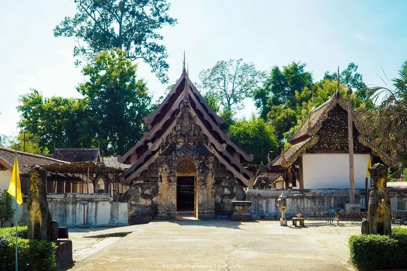
25. Wat Selarattanapapphataram (Wat Lai Hin Luang) is located in Lai Hin Subdistrict, Ko Kha District. This ancient temple is notable for Lanna timber architecture and craftsmanship associated with artisans from Kengtung, particularly its wooden viharn, gateways, gables, and carved supporting brackets.
Highlights: Ancient wooden viharn, Lanna architecture, Kengtung craftsmanship, carved naga and Hanuman brackets, vine motifs, gateway architecture, and the atmosphere of an old Ko Kha community.
The viharn is the heart of the temple. Its timber structure has graceful Lanna proportions and is filled with finely carved details. Visitors who look only at the overall building may miss the craftsmanship of its gables, brackets, and smaller decorative elements.
The workmanship reflects relationships between Lanna and Kengtung, where craftsmen, monks, and artistic knowledge moved between communities over long periods. As a result, the temple’s design is both recognizably Lanna and distinct from many other temples in the region.
The temple stands within a quiet rural community in Ko Kha District, making it suitable for travelers who want to spend time studying historic architecture rather than making only a short photography stop.
Visitors interested in conservation should observe the traditional use of timber and structural techniques, which provide valuable insight into local craftsmanship before concrete construction became widespread.
The temple can be combined with Wat Phra That Lampang Luang and Wat Phra That Chom Ping on a Ko Kha temple route and is especially suitable for travelers interested in ancient temples and Lanna art.
Open Days: Daily Opening Hours: 07:00 – 17:00
Getting There: From Lampang city, travel toward Ko Kha District and continue into Lai Hin Subdistrict following signs to the temple. A private car is most convenient and makes it easy to combine with Wat Phra That Lampang Luang.
Map (GPS):Open Google Maps – Wat Lai Hin Luang

26. Wat Phra That Chom Ping is located at Ban Chom Ping in Na Kaeo Subdistrict, Ko Kha District. This ancient temple contains an important chedi, Lanna legends, historic objects, and a natural-color inverted image of the chedi projected inside the ordination hall, a phenomenon that has become one of the temple’s best-known features.
Highlights: Phra That Chom Ping, ordination hall, Viharn Luang, local antiquities museum, and the naturally colored inverted image of the chedi.
Local tradition associates the temple with the reign of King Tilokaraj of Lanna, and Phra That Chom Ping has long been revered by communities in Ko Kha District.
The chedi follows Lanna artistic traditions, while other buildings have been restored during different periods but still preserve elements that illustrate the evolution of Lanna religious architecture in Lampang.
A particularly famous feature is the inverted image of the chedi visible inside a darkened section of the ordination hall. Light enters through a small opening and projects the exterior image in a manner similar to a pinhole camera, creating an upside-down image with natural color.
The temple also contains a museum and local antiquities, adding historical context beyond the optical phenomenon itself.
Wat Phra That Chom Ping can be combined with Wat Phra That Lampang Luang and Wat Lai Hin Luang as part of a full-day route through Ko Kha’s major historic temples.
Open Days: Daily Opening Hours: 08:00 – 18:00
Getting There: From Lampang city, travel toward Ko Kha District along the same general route used for Wat Phra That Lampang Luang, then continue toward Na Kaeo Subdistrict and Ban Chom Ping. The total distance from the city is approximately 26 km.

27. Wat Phra Chedi Sao Lang is located at Ban Wang Mo in Ton Thong Chai Subdistrict, Mueang Lampang District. The ancient temple is immediately recognizable for its group of 20 chedis. In Northern Thai, the word “sao” means twenty, which explains the temple’s name.
Highlights: Group of 20 chedis, Lanna and Burmese artistic influences, the local belief associated with counting all 20 chedis, important Buddha images, and a peaceful temple atmosphere on the outskirts of Lampang.
The group consists of a principal chedi and surrounding smaller chedis arranged within the same sacred precinct, producing a striking visual rhythm unlike temples centered around a single chedi.
The artistic style combines Lanna and Burmese influences, reflecting Lampang’s history as a city with Burmese communities and extensive teak-trading networks.
Local belief holds that a visitor who successfully counts all 20 chedis is a person of merit. Whether approached as a religious belief or cultural tradition, this adds another layer of meaning to walking around the chedi group.
The temple is quiet and can be explored without rushing. It is especially suitable for architecture, religion, and photography enthusiasts, with morning and late-afternoon light often more attractive than the harsh midday sun.
The temple lies on the route toward Wat Phra That Sadet and northern areas of Mueang Lampang District, making it an easy part of a half-day temple itinerary.
Open Days: Daily Opening Hours: 08:00 – 17:00
Getting There: The temple is at Ban Wang Mo, Ton Thong Chai Subdistrict, on the road north from Lampang city toward Chae Hom. It is easily reached by car or motorcycle.

28. Wat Pong Yang Khok is located in Pong Yang Khok Subdistrict, Hang Chat District. The ancient temple is important for both Lanna art and local traditions associated with Queen Chamadevi. Its most notable features include a historic wooden viharn and a richly crafted prasat-style mondop, or Khong Phra Chao.
Highlights: Lanna wooden viharn, layered roof, traditional timber construction, lai kham decoration, local craftsmanship, prasat-style mondop, and legends associated with Queen Chamadevi.
The viharn is the temple’s most prominent building. Timber forms the main structure, while the tiered roof and decorative details express both Buddhist devotion and the skills of local craftsmen.
The prasat-style mondop, or Khong Phra Chao, is another feature worth close attention because of its relationship with local religious art and community traditions passed down over generations.
Temple legends connect the site with Queen Chamadevi and routes between Hariphunchai and Khelang Nakhon, giving the temple value as a place where history and community memory overlap, even when some details belong to the realm of local tradition rather than documentary history.
The temple retains the peaceful atmosphere of a local community monastery. It is suitable for travelers who want to see historic woodwork away from crowded tourist areas.
Wat Pong Yang Khok is in Hang Chat District and can be combined with the Thai Elephant Conservation Center and other attractions along the Lampang–Lamphun route without returning to the city center.
Open Days: Daily Opening Hours: 07:00 – 17:00
Getting There: From Lampang city, travel toward Hang Chat District and continue into Pong Yang Khok Subdistrict following signs to the temple. A private car is suitable for combining the visit with the Thai Elephant Conservation Center.
Map (GPS):Open Google Maps – Wat Pong Yang Khok

29. Wat Phra That Sadet is located at Ban Sadet in Sadet Subdistrict, Mueang Lampang District. This important ancient temple contains a sacred chedi, Lanna art, significant bronze Buddha images, and local traditions associated with Queen Chamadevi. The temple is registered as a historic site and remains an important spiritual center for surrounding communities.
Highlights: Lanna-style Phra That Sadet, viharn and ordination hall, important bronze Buddha images, Queen Chamadevi traditions, and the peaceful atmosphere of an ancient temple outside central Lampang.
Phra That Sadet is the temple’s spiritual center. Its Lanna form shares certain similarities with Phra That Lampang Luang but on a smaller scale, allowing architecture enthusiasts to compare chedi forms within Lampang.
Local traditions associate the temple with Queen Chamadevi, placing Wat Phra That Sadet among the sites preserving community memories of relationships between Khelang Nakhon and Hariphunchai.
The temple’s bronze Buddha images and religious art add historical value beyond worship at the chedi. Travelers interested in art should take time to observe the viharn and interior features closely.
The temple is quieter than Lampang’s major city attractions, making it suitable for visitors seeking an unhurried temple route and traditional Lanna religious sites within local communities.
Wat Phra That Sadet can be combined with Wat Phra Chedi Sao Lang and other northern areas of Mueang Lampang District within half a day to one full day.
Open Days: Daily Opening Hours: 06:00 – 18:00
Getting There: From Lampang city, travel north toward Sadet Subdistrict and Ban Sadet. A private car makes it easy to combine the temple with Wat Phra Chedi Sao Lang.
Map (GPS):Open Google Maps – Wat Phra That Sadet

30. Wang Hua Reservoir is located at Ban Pha Lat in Phra Bat Subdistrict, Mueang Lampang District. This peaceful reservoir near the city offers broad water views framed by mountains and is suitable for travelers looking for nature without driving deep into remote mountain areas.
Highlights: Wide reservoir, surrounding mountains, sunset views, quiet atmosphere, a convenient stop along the Lampang–Den Chai route, and easy access from the city.
The reservoir is approximately 18 km from Lampang city and lies only a short distance from the main road, making it suitable as a rest stop or evening viewpoint without requiring a full-day excursion.
The landscape consists of open water backed by mountain ridges. In the evening, the changing light above the hills makes this one of the best times for photography.
The attraction lies in its simplicity. There are relatively few commercial tourism facilities, allowing visitors to sit, enjoy the view, and spend quiet time in nature.
As this is a working reservoir area, visitors should remain within safe public areas, avoid swimming where no designated swimming zone exists, and stay away from restricted irrigation structures.
Wang Hua Reservoir can be combined with Wat Mon Phaya Chae or used as a stop when traveling from Lampang toward Den Chai and Phrae.
Getting There: From Lampang city, take the Lampang–Den Chai route toward Ban Pha Lat, Phra Bat Subdistrict, then turn approximately 300 meters toward the reservoir. A private car is the most convenient option.
Map (GPS):Open Google Maps – Wang Hua Reservoir

31. Wat Tha Ma O is located at Ban Tha Ma O in Wiang Nuea Subdistrict, Mueang Lampang District. This old temple in a historic community beside the Wang River is important for Burmese art, the history of teak merchants, and Lampang’s traditional Pali education.
Highlights: Burmese-style prasat structures and Buddha images, chedi behind the ordination hall, timber architecture from the teak-trade period, traditional Pali education, and its location in Tha Ma O, one of Lampang’s historic neighborhoods.
Tha Ma O was once closely associated with the teak trade and multicultural merchant communities. Economic growth during the late 19th century led to the construction of Burmese-influenced temples, residences, and buildings throughout the neighborhood, making Wat Tha Ma O part of this broader cultural landscape.
Inside the temple are artistic elements noticeably different from standard Lanna architecture, including building forms, decorative details, and Burmese-style Buddha images. Architecture enthusiasts should look carefully at structural and ornamental details rather than focusing only on the overall appearance.
Another important aspect is the temple’s role in Pali education. It once served as an important center for Buddhist textual study and the transmission of religious knowledge in Lampang.
The surrounding Tha Ma O neighborhood is also suitable for walking, with old houses, community streets, and routes near the Wang River. It connects easily with Kad Kong Ta, Wat Pong Sanuk, Wat Phra Kaew Don Tao Suchadaram, and Baan Sao Nak.
Visitors should dress respectfully and maintain a quiet atmosphere because the temple remains active. Historic buildings and religious objects should not be touched or leaned against unnecessarily.
Open Days: Daily Opening Hours: 08:00 – 17:00
Getting There: From central Lampang, travel to Wiang Nuea Subdistrict and the Tha Ma O community. The temple lies close to Kad Kong Ta and other historic areas and is easily reached by car, motorcycle, or local transport.
Map (GPS):Open Google Maps – Wat Tha Ma O
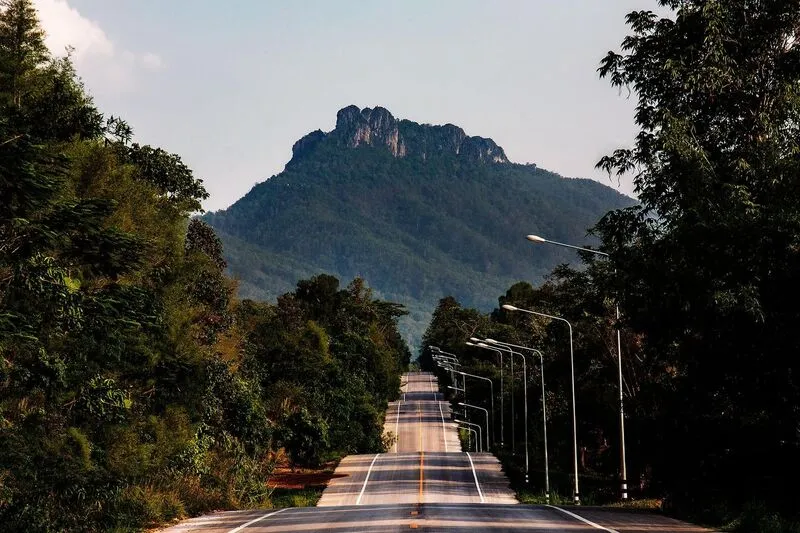
32. Doi Pu Yak is located at Ban Nam Cho, Moo 8, Mueang Pan Subdistrict, Mueang Pan District. The mountain has a distinctive profile, with its ridge appearing divided into two sections when viewed from below, and is a destination for travelers interested in trekking, viewpoints, and the natural landscapes of northern Lampang.
Highlights: Distinctive mountain summit, trekking route, views across Mueang Pan and Chae Hom, mountain ranges, agricultural landscapes, and a hiking experience in a largely natural setting.
The climb differs from viewpoints that can be reached directly by vehicle because travelers must hike and gradually gain elevation through forest and mountain terrain. It is therefore best suited to visitors who are physically prepared and enjoy active outdoor travel.
From higher elevations, hikers can see the Mueang Pan basin, mountains toward Chae Hom, villages, and agricultural land below, providing a broad understanding of northern Lampang’s geography.
Winter is generally the best season for trekking because temperatures are cooler and visibility is often clearer. The rainy season brings lush vegetation but also slippery trails and greater risk, making weather checks important before departure.
Hikers should carry drinking water, portable food, suitable trail footwear, rain or wind protection, and should not leave established routes. This is a natural mountain area without the extensive facilities found at urban attractions.
Doi Pu Yak can be combined with Mae Kong Pin Waterfall, Doi Chik Chong, and other Mueang Pan attractions. Travelers exploring several sites should consider staying at least one night in the area.
Open Days: Daily Opening Hours: 08:00 – 17:00
Getting There: Travel from Mueang Pan town to Ban Nam Cho, Moo 8, Mueang Pan Subdistrict, then continue on foot along the mountain trail. Ask the local community about current trail conditions before beginning the hike.
Map (GPS):Open Google Maps – Doi Pu Yak

33. Doi Chik Chong, also known as Doi Chik Chong Khong Kham, is located at Ban Thung San in Ban Kho Subdistrict, Mueang Pan District. It is both a mountain trekking route and a sacred site for local communities, with an old stupa on the summit serving as an important focus of local faith.
Highlights: Trekking route of approximately 4.5–5 km, a summit chedi more than 200 years old, mountain viewpoint, camping area, and peaceful ridge-top atmosphere.
The ascent requires a reasonable level of fitness because the trail follows hillsides and steadily gains elevation. The destination is not only a scenic viewpoint but also a sacred chedi area respected by local communities for generations.
Along the trail, hikers experience forest, mountain scenery, and quiet surroundings very different from attractions accessible directly by road. Sufficient time should be allowed for climbing, resting, and descending.
The summit area has a pavilion, camping space, and some basic facilities, but travelers should remain self-sufficient and bring enough water, food, and personal equipment.
Winter is the most comfortable season for the climb. During the rainy season, trails may be slippery and cloud or fog can reduce visibility. Anyone planning to camp should coordinate with the local community or site caretaker in advance.
Doi Chik Chong is ideal for travelers seeking a natural route that combines trekking and local spirituality. It can be combined with Mae Kong Pin Waterfall and Doi Pu Yak on a multi-day Mueang Pan itinerary.
Open Days: Daily Opening Hours: 08:00 – 17:00
Getting There: From Mueang Pan District, travel to Ban Thung San, Ban Kho Subdistrict, and begin the mountain trail from the community. The hiking distance is approximately 4.5–5 km. Ask local residents about current trail conditions before setting out.
Map (GPS):Open Google Maps – Doi Chik Chong

34. Mae Cho Fa Waterfall (Tat Mei Waterfall) is located at Ban Thung Hang, Moo 1, Thung Phueng Subdistrict, Chae Hom District, in a forest area of Tham Pha Thai National Park. This remote waterfall has 9 levels, flows throughout the year, and is suitable for travelers who enjoy trekking, nature study, and quiet forest waterfalls.
Highlights: Nine waterfall levels, deep forest, year-round water, nature trails, birdwatching, and especially attractive water flow from May to September.
The waterfall descends through several rock levels, with each section showing a different character, including pools, narrow channels, and water flowing over rock faces. The multi-level landscape offers more variety than a single-drop waterfall.
From May to September, the forest is particularly humid and the waterfall carries more water, making it especially scenic. At the same time, trails become slippery and require more caution than during the dry season.
The area is best suited to visitors who are physically prepared and do not expect extensive tourist facilities. Carry drinking water, light food, rain protection, and suitable trekking shoes.
Birdwatching and observing forest plants are also rewarding because the waterfall lies within a quiet forest ecosystem with relatively little built development.
Swimming should be avoided in strong currents or deep pools, and the area should not be entered during heavy rain because water levels can rise quickly.
Open Days: Daily Opening Hours: 08:00 – 17:00
Getting There: Travel to Ban Thung Hang, Thung Phueng Subdistrict, Chae Hom District, then follow the local access route toward the waterfall. During the rainy season, check road conditions and obtain updated information from local communities or responsible authorities before entering.
Map (GPS):Open Google Maps – Mae Cho Fa Waterfall

35. King Naresuan the Great Monument is located within Ko Kha Municipality, Ko Kha District. It was built in honor of King Naresuan the Great and is associated with historical memory concerning the route taken after the king died at Mueang Hang.
Highlights: Monument to King Naresuan the Great, ceremonial plaza, commemorative activities, and historical context connecting Lampang with routes between Lanna and Ayutthaya.
King Naresuan the Great is one of the most important monarchs in Thai history. Traditions surrounding his death at Mueang Hang led several communities along the route south toward Ayutthaya to preserve memories and memorial sites associated with the king.
The royal statue stands on a raised monument within an open plaza, suitable for paying respects and learning about history, particularly for travelers exploring Ko Kha, where several important temples and historic sites are located.
The site is also used for commemorative ceremonies and community activities on certain occasions, giving it a role beyond that of a monument created simply for photography.
A visit can be combined with Wat Phra That Lampang Luang, Wat Phra That Chom Ping, and Wat Lai Hin Luang, creating a Ko Kha route that includes history, religion, and art.
Morning or late afternoon is the most comfortable time to visit because the site is largely open-air and can become hot around midday.
Getting There: The monument is located within Ko Kha Municipality and can be reached easily by car from Lampang city along the road toward Ko Kha District.

36. Chao Pho Khun Tan Monument is located in Wiang Tan Subdistrict, Hang Chat District. It is both a sacred place and a memorial to Chao Pho Khun Tan, also known as Phaya Boek, an important figure in Lanna history associated with Khelang Nakhon and Wiang Tan.
Highlights: Monument to Phaya Boek, worship plaza, annual ceremonial traditions, the history of Wiang Tan, and location along the Lampang–Chiang Mai route near the Khun Tan area.
Phaya Boek played a role during a period of political transition involving Lanna and Hariphunchai, and stories about him continue to be preserved through legends and community memory in Hang Chat.
The monument therefore functions as both a historic memorial and a place of belief. Local residents visit to pay respects, make wishes, and participate in traditional ceremonies.
Travelers using the Lampang–Chiang Mai road can stop here without a major detour. The site can also serve as an introduction to the history of Wiang Tan and Hang Chat before continuing onward.
The monument stands in an outdoor plaza, so morning or evening is more comfortable than midday. Visitors should remain respectful when local people are worshipping or ceremonies are taking place.
The monument can be combined with the Thai Elephant Conservation Center, Mae Phrai Reservoir, and Wat Pong Yang Khok in a Hang Chat itinerary.
Getting There: From Lampang city, take Highway 11 toward Chiang Mai through Hang Chat District and Wiang Tan Subdistrict, then follow local signs to the monument.

37. Mae Phrai Reservoir, also known as Huai Mae Phrai Reservoir, is located at Ban Thung Hok, Moo 5, Wo Kaeo Subdistrict, Hang Chat District. It is a community water resource with both practical water-management functions and scenic value, surrounded by forest and a quiet rural landscape.
Highlights: Earth dam approximately 341 meters long and 19 meters high, storage capacity of around 3.2 million cubic meters, open water surrounded by nature, scenic views, and the peaceful environment of Hang Chat District.
The reservoir plays an important role in supplying water for agriculture and local use. A visit therefore reveals both attractive scenery and infrastructure directly connected to rural livelihoods.
Trees and open areas around the reservoir make it suitable for resting, sightseeing, and photography. Morning is particularly peaceful, while evening light reflecting on the water and surrounding hills creates a different atmosphere.
This is not a large commercial tourist destination and is best suited to visitors looking for a quiet local place rather than extensive activities or tourist facilities.
Visitors should remain in permitted public areas, avoid swimming in undesignated sections, and stay away from restricted irrigation structures.
Mae Phrai Reservoir can be combined with the Thai Elephant Conservation Center, Wat Pong Yang Khok, and Chao Pho Khun Tan Monument, adding a nature stop to a Hang Chat itinerary.
Getting There: The reservoir is at Ban Thung Hok, Wo Kaeo Subdistrict, approximately 20 km from the Hang Chat District Office. A private car is the most convenient way to visit.
Map (GPS):Open Google Maps – Mae Phrai Reservoir

38. Mae Kong Pin Waterfall is located at Ban Mae Kong Pin, Moo 6, Ban Kho Subdistrict, Mueang Pan District. This natural waterfall is surrounded by forest and has a quiet atmosphere, making it suitable for travelers who want to relax, listen to flowing water, and enjoy the less-crowded natural side of Mueang Pan.
Highlights: Natural waterfall, shaded forest, stream scenery, quiet surroundings, photography, and easy combination with Doi Chik Chong and other Ban Kho attractions.
Mae Kong Pin Waterfall has relatively little built development. Its main appeal lies in the natural environment and peaceful setting, where visitors can follow the stream, rest beneath trees, and enjoy the sound of water without rushing.
The rainy season and early winter bring the greenest scenery and stronger water flow, although dirt paths and wet rocks can become slippery, particularly immediately after rain.
The area suits small groups, families accustomed to nature travel, and photographers. Children should be supervised carefully around pools and wet rocks.
Visitors should take all rubbish away and avoid using products that could contaminate the stream in order to protect water quality and the surrounding ecosystem.
The waterfall can be combined with Doi Chik Chong, Doi Pu Yak, and other Mueang Pan attractions. Staying overnight in the district is recommended for a more relaxed itinerary.
Open Days: Daily Opening Hours: 08:00 – 17:00
Getting There: From Mueang Pan town, travel toward Ban Mae Kong Pin, Moo 6, Ban Kho Subdistrict, then follow the local access route to the waterfall. Check road conditions during the rainy season.

39. Chao Pho Phaya Kham Lue Monument is located in Wichet Nakhon Subdistrict, Chae Hom District. It is an important sacred place for local residents and a site for learning about the historical memory and traditional beliefs of Wichet Nakhon.
Highlights: Chao Pho Phaya Kham Lue Monument, worship area, annual ceremonial traditions, the history of Wichet Nakhon, and a convenient stop on the route to Wat Chaloem Phra Kiat Phrachomklao Rachanuson.
Chao Pho Phaya Kham Lue is remembered as a local ruler associated with Wichet Nakhon and is highly respected by communities in the area. His memory has been preserved through worship and local ceremonies.
The monument therefore combines historical memory with living belief. Local people visit to make offerings, ask for blessings, and participate in ceremonial events, so the site continues to play an active role in community life rather than existing only as a tourist monument.
Visitors can use the site as an introduction to Chae Hom before continuing to Wat Chaloem Phra Kiat Phrachomklao Rachanuson, Mae Cho Fa Waterfall, or natural attractions farther north.
The monument is in an open-air plaza. Morning or evening is more comfortable than midday, and visitors should be respectful when ceremonies or worship are taking place.
For travelers interested in local history, the monument adds context to a Chae Hom itinerary that might otherwise focus only on mountain temples and nature.
Open Days: Daily Opening Hours: 08:00 – 17:00
Getting There: The monument is located in Wichet Nakhon Subdistrict, Chae Hom District, and can be reached easily from the district center before continuing to attractions farther north.

40. Doi Farang is located within Mon Phaya Chae Forest Park in Phichai Subdistrict, Mueang Lampang District. At approximately 895 meters above sea level, it is an ecotourism destination suitable for hiking, camping, nature study, and elevated views over Lampang city and the Mae Moh area.
Highlights: Summit approximately 895 meters above sea level, hiking trail, views over Lampang and Mae Moh, camping areas, forest close to the city, and a military survey marker more than 100 years old on the summit.
Doi Farang is a good choice for travelers who want a forest hike without traveling far from Lampang city. It lies within Mon Phaya Chae Forest Park, an area of approximately 18,579 rai that preserves important forest and mountain terrain close to the urban area.
The trail passes through open forest and hills before reaching ridge areas with wider views. From higher ground, visitors can see both Lampang city and landscapes toward Mae Moh.
The old military survey marker on the summit adds historical and geographical interest, connecting Doi Farang not only with scenic travel but also with earlier surveying and mapmaking of the region.
Hikers should prepare physically and carry suitable footwear, drinking water, and outdoor equipment. Although the forest lies close to the city, the trail remains natural and should not be underestimated simply because of its proximity to urban Lampang.
Winter is the best season for trekking and camping. During the rainy season, trail conditions should be checked in advance, and hiking should be avoided during heavy rain, thunderstorms, or poor visibility.
Open Days: Daily Opening Hours: 06:00 – 18:00
Getting There: From Lampang city, travel toward Phichai Subdistrict and enter Mon Phaya Chae Forest Park, then continue on foot toward Doi Farang. Ask park staff about trail and camping conditions before beginning the hike.
Map (GPS):Open Google Maps – Doi Farang
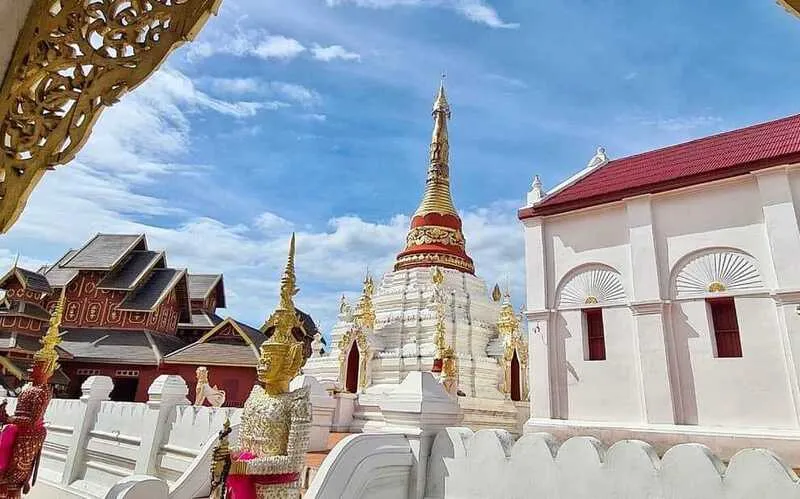
41. Wat Mon Santhan, also known locally as Wat Mon Pu Yak, is located on Pa Kham Road in Phra Bat Subdistrict, Mueang Lampang District. This historic temple occupies a small hill east of the Wang River and is notable for combining Burmese architecture, masonry buildings influenced by Western design, and Buddhist structures reflecting Lampang’s cultural diversity during the teak-trade era.
Highlights: Burmese-style buildings, wooden monks’ quarters, viharn, ordination hall, Chulamani-style chedi, hilltop location in the city, and an old-temple atmosphere connected with communities east of the Wang River.
In Northern Thai, “mon” refers to a hill or small elevated area. The temple therefore differs from temples built entirely on flat ground. Although the elevation is modest, entering the grounds creates a sense of separation from the roads and communities below, contributing to a peaceful atmosphere within the city.
Some buildings display clear Burmese influence, while masonry construction and certain details show Western design elements. This combination reflects the Lampang environment of the teak era, when merchants, craftsmen, and communities from different cultural backgrounds settled in the city.
The Chulamani-style chedi is one of the temple’s important visual elements. Architecture enthusiasts should examine the chedi, viharn, monks’ quarters, and surrounding building details because the temple’s identity comes from the entire ensemble rather than a single structure.
Wat Mon Santhan is particularly suitable for travelers extending a Burmese-temple route through Lampang after visiting Wat Si Chum and Wat Tha Ma O. Together, these sites make it easier to understand how multicultural influences shaped the city.
Because the temple remains active, visitors should dress respectfully, keep noise low, and avoid touching old structures or fragile decorations.
Open Days: Daily Opening Hours: 06:00 – 18:00
Getting There: Wat Mon Santhan is on Pa Kham Road, Phra Bat Subdistrict, not far from central Lampang. It can be reached easily by car, motorcycle, or local transport.
Map (GPS):Open Google Maps – Wat Mon Santhan

42. Phra Sadet Waterfall, formerly known as Wang Ngoen Waterfall, is located at Ban Wang Ngoen, Moo 14, Nikhom Phatthana Subdistrict, Mueang Lampang District, within the Mae Sai Kham Forest Plantation of the Forest Industry Organization. This limestone waterfall has natural, geological, and historical significance.
Highlights: Limestone waterfall, clear green water, 4 large pool levels, more than 20 smaller cascading pools, a waterfall cliff approximately 10 meters high, and the forest atmosphere of Mae Sai Kham.
The waterfall’s distinctive form results from water flowing over limestone and collecting in a series of natural pools. This creates a landscape very different from a single high waterfall, with some areas forming shallow terraces and others deeper green pools whose appearance changes with the rock and light.
The surrounding forest plantation is shaded and suitable for relaxed nature walks. Morning and midday light can illuminate the pools and make their color particularly visible.
Visitors should be careful on limestone surfaces, which can be slippery, especially during the rainy season. Avoid climbing wet cliff areas or entering pools where depth cannot be assessed, and do not swim during heavy rain or strong water flow.
Phra Sadet Waterfall is suitable for families, groups of friends, and travelers seeking nature close to Lampang city without traveling to more distant districts. It works well as a nature stop on routes north of the city.
The royal name of the waterfall adds a historical dimension to its natural significance. Travelers interested in Lampang’s forestry history can also connect the site with the province’s long relationship with forest resources and forestry industries.
Getting There: From Lampang city, travel toward Ban Wang Ngoen, Moo 14, Nikhom Phatthana Subdistrict, and enter the Mae Sai Kham Forest Plantation area. A private car is recommended, and road conditions should be checked during the rainy season.
Map (GPS):Open Google Maps – Phra Sadet Waterfall
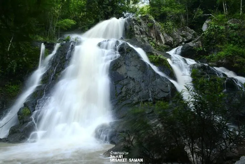
43. Mae Wa National Park is located around Mae Wa Subdistrict in Thoen District in southern Lampang. The extensive protected forest contains continuous mountain ranges, several forest types, waterfalls, limestone caves, and nature routes, making it ideal for travelers who want to explore beyond Lampang’s urban and cultural zones.
Highlights: Doi Ta Chi at approximately 1,027 meters, mixed deciduous forest, dry dipterocarp forest, pine forest, dry evergreen forest, waterfalls, limestone caves, nature trails, and important watershed forest in southern Lampang.
The park consists of complex mountains with considerable elevation differences, allowing several ecological systems to occur within the same protected area, from relatively dry dipterocarp forest to dry evergreen and pine forest at higher elevations.
Doi Ta Chi is the highest peak in the area at approximately 1,027 meters above sea level, giving the upper zone cooler temperatures and making it suitable for trekking, botanical study, and elevated landscape views.
In addition to mountains, the park contains waterfalls and limestone caves. Visitors interested in geology, forest ecology, and stream systems can explore several environments in one trip, although individual attractions are spread across a wide area and should be planned in advance.
Winter is the most comfortable season for trekking and general nature travel. During the rainy season, forests are lush and waterfalls more impressive, but flash water, slippery trails, and road conditions can limit access, so park announcements should be checked beforehand.
For travelers driving along the northern highway between Lampang and Tak or exploring the southern part of the province, Mae Wa National Park reveals a very different side of Lampang from its old town and Lanna temples.
Open Days: Daily Opening Hours: 08:00 – 16:30
Getting There: Travel to Thoen District and continue toward Mae Wa Subdistrict following signs for Mae Wa National Park. A private car is recommended. Ask park staff for current information before entering remote areas or beginning nature trails.
Map (GPS):Open Google Maps – Mae Wa National Park

44. Wat Nang Liao (Wiang Nuea) is located at Ban Nang Liao, Moo 1, Suchada Road, Wiang Nuea Subdistrict, Mueang Lampang District. Built in 1877, the temple is significant to the history of the Wiang Nuea community, local legends, and the religious life of Lampang’s old town.
Highlights: Historic community temple in Wiang Nuea, ordination hall, sermon hall, monks’ residences, merit-making spaces, local traditions, and location close to Wat Tha Ma O and other historic sites north of the Wang River.
Wiang Nuea is an old urban district containing a concentration of temples and long-established communities. Wat Nang Liao is therefore best appreciated as part of this network of neighborhood temples, helping visitors understand the historic urban plan and community life rather than treating the temple as an isolated monument.
The temple’s name is associated with local legends and community memory, giving the site value as intangible cultural heritage in addition to its religious buildings.
The atmosphere is generally quiet, making Wat Nang Liao suitable for worship and a slow visit to a traditional community temple. Travelers who prefer less-crowded places can observe how an urban monastery remains closely connected with surrounding residents.
The temple can be combined with Wat Tha Ma O, Pratu Ma City Wall, Wat Phra Kaew Don Tao Suchadaram, and Wang Nuea Road within a half-day old-town route.
Visitors should dress respectfully and remain aware of community activities. If ceremonies or merit-making activities are taking place, keep an appropriate distance and avoid disturbing participants.
Open Days: Daily Opening Hours: 08:00 – 17:00
Getting There: From central Lampang, enter Wiang Nuea Subdistrict and follow Suchada Road toward Ban Nang Liao. The temple lies close to Tha Ma O and other old-town sites.
Map (GPS):Open Google Maps – Wat Nang Liao

45. Ratsada Market (Talat Hua Khua) is located near the head of Ratsada Bridge on Phra Kaew Road in central Lampang. It is an important local market that begins before dawn and becomes active again in the afternoon and evening, making it ideal for travelers interested in fresh food, Northern Thai ingredients, and everyday city life.
Highlights: Traditional morning market, Northern Thai food, fresh produce, local vegetables, regional sweets, prepared dishes, and a convenient location close to the Wang River and Ratsada Bridge.
The Northern Thai phrase “hua khua” means the head of a bridge, reflecting the market’s location near Ratsada Bridge and the Wang River. This position has long been connected with transportation and trade within the community.
Early morning is when the market is at its liveliest. Local shoppers arrive for ingredients, fresh produce, vegetables, meat, and prepared food, making this the best time for food-focused travelers to experience Lampang at the rhythm of everyday local life.
Regional food and local ingredients provide insight into Lampang’s food culture beyond restaurant dining, particularly seasonal vegetables, chili dips, Northern dishes, and sweets purchased by local residents.
The market becomes active again in the afternoon and evening, which is convenient for visitors who do not want an early start. However, the most traditional fresh-market atmosphere is found in the morning.
Ratsada Market can be combined easily with Kad Kong Ta, Wang Nuea Road, Wat Phra Kaew Don Tao Suchadaram, and attractions along the Wang River, making it an excellent place to begin a day in Lampang city.
Open Days: Daily Opening Hours: Morning 04:00 – 10:00 / Afternoon and evening 15:00 – 20:00
Getting There: The market is on Phra Kaew Road near the head of Ratsada Bridge and the Wang River in central Lampang. It can be reached by car, motorcycle, local transport, or on foot from nearby attractions.
Map (GPS):Open Google Maps – Ratsada Market

46. Pratu Ma City Wall of Khelang Nakhon is an important surviving trace of the ancient Khelang Nakhon city wall in Lampang. It provides evidence of historic city planning, defensive structures, and the development of early communities within the Wang River basin.
Highlights: Surviving earthen city wall, ancient Khelang Nakhon gate line, Pratu Man or Pratu Ma, historic urban plan, and archaeological evidence connected with Lanna settlement history.
Khelang Nakhon was an important early city within the Wang River basin. The first defensive wall enclosed an area of approximately 600 rai, with several kilometers of fortifications defining the settlement and protecting its inhabitants.
Historically, the city had several gates, including Pratu Man or Pratu Ma, Pratu Tan, Pratu Ton Phueng, Pratu Pha Bong, Pratu Tha Nang Liao, and Pratu Pong. These names survive in the names of streets, temples, and neighborhoods in modern Lampang.
The original defensive structures were primarily earthen and were reinforced with brick in later periods. The surviving remains are valuable archaeological evidence demonstrating that the ancient city consisted not only of temples but also of sophisticated defensive and urban-planning systems.
The city wall is best explored together with temples and streets in Wiang Nuea because visitors can connect the location of religious sites with former gateways and the historic settlement pattern.
As this is an outdoor archaeological site, visitors should not climb, step on, or damage surviving wall sections and should help keep the area clean.
Open Days: Daily Opening Hours: 24 hours
Getting There: The remains are located in Wiang Nuea, Mueang Lampang District. They can be included in a walking or driving old-town route together with Wat Tha Ma O, Wat Nang Liao, and Wang Nuea Road.

47. Wang Nuea Road Cultural Street is located in Wiang Nuea Subdistrict, Mueang Lampang District, and becomes especially lively on Friday evenings when the historic street turns into a cultural market featuring local food, handicrafts, handmade products, performances, and community activities.
Highlights: Friday evening cultural street, local food, handicrafts, traditional performances, historic temples and monuments, Ku Chao Ya Suta, and the atmosphere of the Wiang Nuea community.
The road is more than a market venue because it lies within Lampang’s historic urban district, surrounded by temples, communities, and archaeological remains. Visitors can therefore explore urban heritage while also eating local food and buying products directly from community vendors.
On Friday evenings, additional stalls and activities bring life back to an old district that is normally relatively quiet. The experience remains closer to a community cultural market than a large tourist-oriented night market.
Local food is an important part of the visit, allowing travelers to sample several dishes in small portions. Crafts and handmade goods also showcase community skills while generating income within the neighborhood.
History enthusiasts should arrive before the market becomes busy to walk among temples and historic sites around Wiang Nuea, then return to the cultural street in the evening. This creates a full day combining the historic and contemporary life of Lampang.
Wang Nuea Road can be combined easily with Wat Tha Ma O, Wat Nang Liao, Pratu Ma City Wall, and Wat Phra Kaew Don Tao Suchadaram.
Open Days: Every Friday Opening Hours: 18:00 – 21:00
Getting There: The cultural street is on Wang Nuea Road in Wiang Nuea Subdistrict. During Friday market hours, parking outside the main activity area and walking in is recommended to reduce traffic congestion.

48. Mon Phaya Chae Forest Park is located in Phichai Subdistrict, Mueang Lampang District. Covering approximately 18,579 rai, this forest close to the city allows visitors to move quickly from Lampang’s historic urban atmosphere into hills, forest trails, reservoirs, and scenic viewpoints.
Highlights: Forest close to the city, hills, Lampang city viewpoints, Huai Cho Reservoir, nature trails, Doi Farang, and a natural environment only around 6 km from central Lampang.
The forest park lies within the Mae Yang–Mae Ang National Reserved Forest and consists of hills and sections of open woodland. It serves as an important green space for Lampang city and a recreational area for local residents.
Viewpoints provide broad perspectives back toward Lampang city during both the day and evening, revealing the relationship between the urban basin and the mountain ranges surrounding the province.
Huai Cho Reservoir adds a calm waterside environment suitable for relaxing and walking, while travelers seeking more activity can plan a hike to Doi Farang within the same forest area.
The park is suitable for families, runners, hikers, and travelers with limited time who want to experience nature outside the city without traveling as far as Chae Son or Ngao.
Morning and evening are the most comfortable times to visit. Anyone planning to hike or camp should ask park staff about current conditions and designated areas in advance.
Open Days: Daily Opening Hours: 06:00 – 18:00
Getting There: From Lampang city, travel approximately 6 km toward Phichai Subdistrict. The park can be reached by car or motorcycle and combined with Wat Mon Phaya Chae and Doi Farang on the same day.

49. Mae Mok Reservoir is located in Wiang Mok Subdistrict, Thoen District. This large reservoir developed under a royal initiative plays important roles in irrigation, agriculture, household water supply, and water management for southern Lampang and nearby areas of Sukhothai Province.
Highlights: Reservoir area of approximately 10,000 rai, water body around 2 km wide, dam crest approximately 1.9 km long, surrounding mountains and forest, sunrise and sunset views, and an important water-management role linking Lampang and Sukhothai.
Mae Mok Reservoir is large enough to feel very different from small community reservoirs. Its broad water surface against surrounding mountains makes it suitable for scenic viewing and photography, particularly on clear days.
The reservoir’s primary purpose is to supply water for agriculture and daily use. Beneficiary areas extend into both Thoen District in Lampang and Thung Saliam District in Sukhothai, making the project far more important to local communities than tourism alone.
The approach road passes through natural and rural scenery, so the journey itself is part of the experience. It is particularly suitable for travelers who enjoy road trips through countryside and want to see southern Lampang beyond the main urban area.
Morning and evening are the best times to visit because temperatures are lower and light over the water is softer than at midday. Visitors should remain in public areas and avoid restricted water-management structures.
Mae Mok Reservoir can be combined with Mae Wa National Park and Thoen, making it suitable for a 1–2 day exploration of southern Lampang.
Getting There: From Thoen District, turn toward Wiang Mok Subdistrict. The route from the main highway to the reservoir is approximately 50 km. A private car is recommended, and travelers should ensure they have sufficient fuel before entering the interior route.
Map (GPS):Open Google Maps – Mae Mok Reservoir
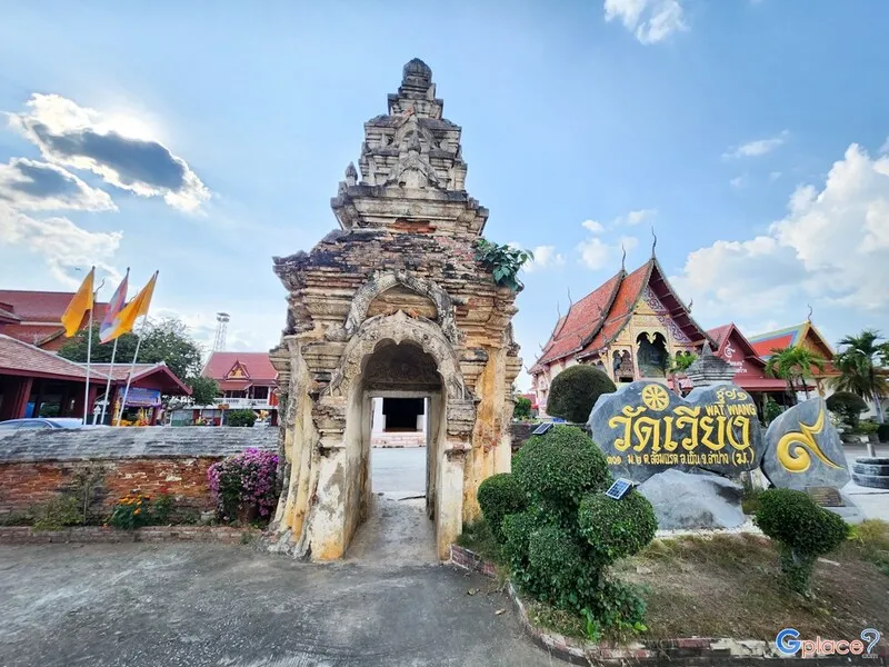
50. Wat Wiang is located at 301 Ban Wiang, Lom Raet Subdistrict, Thoen District. This important temple stands within the ancient urban area of Thoen and broadens the historical story of Lampang beyond the provincial capital, as Thoen once served as a frontier town and an important route linking Lanna with territories farther south.
Highlights: Khong-style gateway, open Lanna viharn, chedi, Chiang Saen-style Buddha images, and the historical context of Thoen or Sangkhatoen as part of Northern Thailand’s old communication routes.
Wat Wiang lies within the old settlement of Thoen. Its structures therefore have value both as religious monuments and as evidence of historical settlement, particularly for visitors interested in how secondary towns within the Lanna network functioned as routes of communication and defensive outposts.
The Khong-style gateway is a notable feature influenced by the gateway form seen at Wat Phra That Lampang Luang, while the viharn retains an open character associated with traditional Lanna architecture. This makes it possible to compare religious architecture in Thoen with important temples in central Lampang Province.
Chiang Saen-style Buddha images and other religious artworks inside the temple reflect the relationship between Thoen and the broader Lanna cultural network, which extended beyond the boundaries of present-day Lampang Province.
The temple retains the atmosphere of an active community monastery. It is a good starting point for travelers who want to understand Thoen at a slower pace before continuing to natural attractions in southern Lampang.
Ending the list with Wat Wiang completes this journey through 50 Lampang attractions, covering Khelang Nakhon, the Wang River old town, Ko Kha, Hang Chat, Chae Hom, Mueang Pan, Ngao, Mae Moh, and finally Thoen in the southern part of the province.
Open Days: Daily Opening Hours: 08:00 – 17:00
Getting There: Wat Wiang is at Ban Wiang, Lom Raet Subdistrict, Thoen District. From Phahonyothin Road, enter Thoen town and follow local roads to the temple. It can be combined with Mae Wa National Park and Mae Mok Reservoir.
Map (GPS):Open Google Maps – Wat Wiang
| Travel Category | Recommended Places |
| Major Lampang Landmarks | 1. Wat Phra That Lampang Luang 2. Kad Kong Ta Walking Street 3. Lampang Horse Carriages 4. Thai Elephant Conservation Center 5. Wat Chaloem Phra Kiat Phrachomklao Rachanuson 6. Chae Son National Park |
| Important Temples and Religious Sites | 1. Wat Phra That Lampang Luang 2. Wat Chaloem Phra Kiat Phrachomklao Rachanuson 3. Wat Phra Kaew Don Tao Suchadaram 4. Wat Pong Sanuk Nuea 5. Wat Si Chum 6. Wat Mon Phaya Chae 7. Wat Lai Hin Luang 8. Wat Phra That Chom Ping 9. Wat Phra Chedi Sao Lang 10. Wat Pong Yang Khok 11. Wat Phra That Sadet 12. Wat Tha Ma O 13. Wat Mon Santhan 14. Wat Nang Liao 15. Wat Wiang |
| Burmese Architecture and the Teak-Concession Era | 1. Wat Si Chum 2. Wat Tha Ma O 3. Wat Mon Santhan 4. Baan Sao Nak 5. Wat Phra Kaew Don Tao Suchadaram |
| Old Town and History | 1. Kad Kong Ta Walking Street 2. Baan Sao Nak 3. Nakhon Lampang Railway Station 4. Hor Pum Lakhon Museum 5. Pratu Ma City Wall of Khelang Nakhon 6. Wang Nuea Road Cultural Street 7. Ratsada Market 8. King Naresuan the Great Monument 9. Chao Pho Khun Tan Monument 10. Chao Pho Phaya Kham Lue Monument |
| Nature and Mountains | 1. Chae Son National Park 2. Doi Kio Fin 3. Doi Pu Yak 4. Doi Chik Chong 5. Doi Farang 6. Mon Phaya Chae Forest Park 7. Tham Pha Thai National Park 8. Mae Wa National Park |
| Waterfalls and Natural Streams | 1. Mae Pan Waterfall 2. Mae Kae Waterfall 3. Mae Cho Fa Waterfall 4. Mae Kong Pin Waterfall 5. Phra Sadet Waterfall 6. Chae Son Waterfall inside Chae Son National Park |
| Reservoirs and Scenic Waterscapes | 1. Kiu Lom Dam 2. Samphao Thong Rafting 3. Wang Hua Reservoir 4. Mae Phrai Reservoir 5. Mae Mok Reservoir |
| Geology and Unusual Natural Attractions | 1. Lom Phu Khiao 2. Tham Pha Thai National Park 3. Phra Sadet Waterfall 4. Mae Wa National Park |
| Learning Attractions and Family Trips | 1. Thai Elephant Conservation Center 2. Mae Moh Mine 3. Mae Moh Viewpoint Pavilion 4. Hor Pum Lakhon Museum 5. Nakhon Lampang Railway Station 6. Ban Suan Ceramics |
| Recommended Photography Locations | 1. Wat Chaloem Phra Kiat Phrachomklao Rachanuson 2. Doi Kio Fin 3. Lom Phu Khiao 4. Mae Moh Viewpoint Pavilion 5. Kad Kong Ta Walking Street 6. Nakhon Lampang Railway Station 7. Baan Sao Nak 8. Mae Mok Reservoir |
| Best for Adventure Travelers | 1. Doi Pu Yak 2. Doi Chik Chong 3. Doi Farang 4. Tham Pha Thai National Park 5. Mae Cho Fa Waterfall 6. Mae Wa National Park |
| Lampang City Zone | Kad Kong Ta, Wat Phra Kaew Don Tao Suchadaram, Wat Pong Sanuk, Baan Sao Nak, Lampang Horse Carriages, Wat Si Chum, Nakhon Lampang Railway Station, Hor Pum Lakhon Museum, Wat Mon Phaya Chae, Wat Phra Chedi Sao Lang, Wat Phra That Sadet, Wat Tha Ma O, Doi Farang, Wat Mon Santhan, Phra Sadet Waterfall, Wat Nang Liao, Ratsada Market, Pratu Ma City Wall, Wang Nuea Road Cultural Street, and Mon Phaya Chae Forest Park |
| Ko Kha Zone | 1. Wat Phra That Lampang Luang 2. Wat Lai Hin Luang 3. Wat Phra That Chom Ping 4. King Naresuan the Great Monument |
| Hang Chat Zone | 1. Thai Elephant Conservation Center 2. Wat Pong Yang Khok 3. Chao Pho Khun Tan Monument 4. Mae Phrai Reservoir |
| Chae Hom Zone | 1. Wat Chaloem Phra Kiat Phrachomklao Rachanuson 2. Kiu Lom Dam 3. Samphao Thong Rafting 4. Mae Cho Fa Waterfall 5. Chao Pho Phaya Kham Lue Monument |
| Mueang Pan–Chae Son Zone | 1. Chae Son National Park 2. Mae Pan Waterfall 3. Doi Kio Fin 4. Lan Dok Siao Blooming Field 5. Doi Pu Yak 6. Doi Chik Chong 7. Mae Kong Pin Waterfall |
| Ngao Zone | 1. Tham Pha Thai National Park 2. Lom Phu Khiao 3. Mae Kae Waterfall |
| Mae Moh Zone | 1. Mae Moh Mine 2. Mae Moh Viewpoint Pavilion |
| Thoen–Southern Lampang Zone | 1. Mae Wa National Park 2. Mae Mok Reservoir 3. Wat Wiang |
| 1-Day Lampang Itinerary — Old Town | Ratsada Market → Wat Phra Kaew Don Tao Suchadaram → Baan Sao Nak → Wat Pong Sanuk → Hor Pum Lakhon Museum → Lampang horse-carriage ride → Kad Kong Ta Walking Street |
| 1-Day Lampang Itinerary — Ko Kha | Wat Phra That Lampang Luang → Wat Lai Hin Luang → Wat Phra That Chom Ping → King Naresuan the Great Monument |
| 1-Day Lampang Itinerary — Chae Hom–Chae Son | Wat Chaloem Phra Kiat Phrachomklao Rachanuson → Chae Son National Park → Mae Pan Waterfall → Overnight in Mueang Pan or Chae Son |
| 2 Days / 1 Night in Lampang | Day 1: Wat Phra That Lampang Luang → Lampang Old Town → Horse carriage → Kad Kong Ta Day 2: Wat Chaloem Phra Kiat Phrachomklao Rachanuson → Chae Son National Park |
| 3 Days / 2 Nights in Lampang | Day 1: Lampang city, temples, old town, horse carriage, and Kad Kong Ta Day 2: Ko Kha → Thai Elephant Conservation Center → Hang Chat Day 3: Chae Hom → Wat Chaloem Phra Kiat Phrachomklao Rachanuson → Chae Son National Park |
| 4 Days / 3 Nights in Lampang | Day 1: Lampang Old Town Day 2: Ko Kha–Hang Chat Day 3: Chae Hom–Mueang Pan–Chae Son Day 4: Choose Mae Moh or Ngao–Lom Phu Khiao according to your interests |
| Visiting All 50 Attractions | Allow approximately 7–10 days and divide the journey into Lampang City, Ko Kha, Hang Chat, Mae Moh, Chae Hom, Mueang Pan–Chae Son, Ngao, and Thoen–Southern Lampang zones. This reduces unnecessary backtracking and gives enough time to explore each area properly. |
| Best Time to Visit Lampang | November through February is generally the best period for visiting Lampang because temperatures are cooler and conditions suit old-town exploration, hiking, mountain viewpoints, and Chae Son. The rainy season is excellent for waterfalls and lush green forest, but road and trail conditions should be checked before entering natural areas. |
| Getting Around Lampang Province | Within Lampang city, travelers can use local transport, horse carriages, or walk in selected districts. For Chae Hom, Mueang Pan, Ngao, Mae Moh, Hang Chat, and Thoen, a private or rental car is much more convenient. |
| Food and Souvenirs | Northern Thai food, khao soi, gaeng hung lay, nam prik noom, sai ua, local dishes from Ratsada Market and Kad Kong Ta, as well as rooster bowls, Lampang ceramics, wood products, handicrafts, and community-made goods. |
| Safety Advice | Mountain trails, waterfalls, caves, and some park areas may be affected by rain, fog, changing water levels, or official closures. Check weather and current site conditions before travel and remain on designated routes. |
Frequently Asked Questions (FAQ)
Q: Where should first-time visitors go in Lampang?
A: Start with Wat Phra That Lampang Luang, Kad Kong Ta Walking Street, a Lampang horse-carriage ride, Wat Phra Kaew Don Tao Suchadaram, and Wat Pong Sanuk. If you have more time, add Wat Chaloem Phra Kiat Phrachomklao Rachanuson and Chae Son National Park.
Q: How should I plan a 1-day Lampang itinerary?
A: With only 1 day, focus on the city. Begin early at Ratsada Market, then visit Wat Phra Kaew Don Tao Suchadaram, Baan Sao Nak, Wat Pong Sanuk, Hor Pum Lakhon Museum, take a horse-carriage ride around the old town, and finish at Kad Kong Ta in the evening.
Q: How many days are needed to explore Lampang reasonably well?
A: Around 3–4 days is suitable for the main landmarks in Lampang city, Ko Kha, Hang Chat, Chae Hom, and Chae Son. If you also want to explore Ngao, Mae Moh, Mueang Pan, and southern Lampang, allow around 7–10 days.
Q: Which months are best for visiting Lampang?
A: November through February is generally the most comfortable season because temperatures are cooler and outdoor travel is easier. The rainy season is excellent for waterfalls and lush forest, but road and trail conditions should be checked before traveling.
Q: Which Lampang attractions are suitable for families?
A: The Thai Elephant Conservation Center, Mae Moh Mine, Hor Pum Lakhon Museum, Lampang horse carriages, Kad Kong Ta, Wat Phra That Lampang Luang, and Chae Son National Park are all suitable for family trips.
Q: Which natural attractions in Lampang should not be missed?
A: Recommended nature destinations include Chae Son National Park, Doi Kio Fin, Lom Phu Khiao, Tham Pha Thai National Park, Doi Chik Chong, Doi Farang, Phra Sadet Waterfall, and Mae Wa National Park.
Q: Where can I see a sea of mist in Lampang?
A: Doi Kio Fin is one of Lampang’s best places for misty mountain views and sunrise, particularly during winter. However, a sea of mist depends on humidity, temperature, wind, and the weather on each individual day.
Q: Are Lampang horse carriages still operating?
A: Yes. Horse carriages still operate within Lampang city and remain one of the province’s best-known symbols. Visitors can choose sightseeing routes through the old town, temples, and historic building districts according to available services.
Q: Why does Lampang have so many Burmese-style temples?
A: During the prosperous teak-concession era, many Burmese merchants, wealthy patrons, and workers settled in Lampang. Their presence led to the construction of temples and buildings with Burmese architectural influences, including Wat Si Chum, Wat Tha Ma O, and Wat Mon Santhan.
Q: What is special about Wat Phra That Lampang Luang?
A: Its highlights include an exceptionally well-preserved traditional Lanna temple plan, Phra That Lampang Luang, Viharn Luang, Viharn Nam Taem, the Khong Gate, historic woodwork, and the inverted chedi image phenomenon inside the Phra Bat pavilion.
Q: Do visitors need to climb to reach Wat Chaloem Phra Kiat Phrachomklao Rachanuson?
A: Yes. Reaching the upper mountain area requires travel from the base and walking up stairs in some sections. Visitors should wear suitable footwear, carry drinking water, and consider their physical condition before climbing.
Q: Are there ceramic attractions in Lampang?
A: Yes. Lampang is famous for ceramics and rooster bowls. Visitors can explore ceramic learning and display spaces such as Ban Suan Ceramics and shop for locally made ceramic products throughout the province.
Q: Can visitors swim at Lom Phu Khiao?
A: Swimming is not recommended. The natural pool is deep and lies within a limestone sinkhole environment. Visitors should stay within designated viewing areas and should not climb down toward the edge of the water.
Q: Do I need to rent a car to travel around Lampang?
A: Not necessarily if you are staying within central Lampang, where local transport, horse carriages, and walking can cover several attractions. However, a private or rental car is much more convenient for Chae Hom, Mueang Pan, Ngao, Mae Moh, Hang Chat, and Thoen.
Q: How many days should I allow if I want to visit all 50 attractions?
A: Allow approximately 7–10 days and divide the trip into Lampang City, Ko Kha, Hang Chat, Mae Moh, Chae Hom, Mueang Pan–Chae Son, Ngao, and Thoen–Southern Lampang zones. This reduces unnecessary backtracking and gives you enough time to explore each area properly.
 Category: ●Travel Articles, Recipes
 Group: ●Travel Review, Food Review
Last Update : 2 WeekAgo
 Last Update : 2 WeekAgo
Recommend

 Art, Culture and Heritage
 Historical Sites and Monuments(2)
 Landmarks and Memorials(5)
 Art, Craft Centres, Tradition(10)
 Museums(4)
 Historic Homes and Cities(1)
 Places of Worship
 Temple(86)
 Other Sacred Sites(9)
 Research and Development
 Royal Project(2)
 Suburban Living
 Village, Community(3)
 Local Market(2)
 Nature and Wildlife
 National Parks and Marine Reserves(6)
 Mountain (Doi)(4)
 Dam, Reservoir, Lake(11)
 Waterfalls(15)
 Hot Springs(1)
 Caves(12)
 Flower Field(1)
 River, Canal(1)
 Bays and Beaches(1)
 Other natural attractions(4)
 Entertainment and Agricultural
 Animal camps and shows(1)
 Farms, Parks and Ecotourism(2)
 Outdoor and Adventure Activities(2)
 Shopping
 Shopping and Night Market(2)
 Spas and Wellness
 Spas and Wellness(1)
Travel Review, Food Review(1)


