
lovethailand home >Northeastern Travel Attractions >Loei Travel Attractions > 30 Best Places to Visit in Loei Northeastern Thail..
TL;DR: 30 Best Places to Visit in Loei Northeastern Thailand.
30 Best Places to Visit in Loei Northeastern Thailand
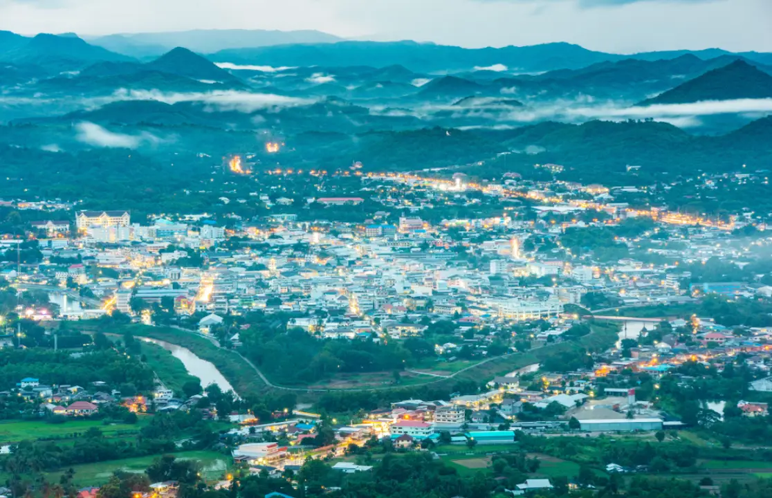
30 Best Places to Visit in Loei Loei is one of the most distinctive travel destinations in Northeastern Thailand, known for its mountains, highlands, forests, cliffs, the Mekong River, historic riverside communities, and villages that continue to preserve strong local traditions. For first-time visitors, the must-see destinations include Chiang Khan, Phu Kradueng National Park, Phu Ruea National Park, Phu Luang Wildlife Sanctuary, Kaeng Khut Khu, Phu Pa Po, and Dan Sai. If you have only 1 day, it is best to focus on a single zone such as Chiang Khan or Phu Ruea. With 2–3 days, Chiang Khan, Phu Ruea, and Dan Sai can be combined, while a 4–5 day trip allows time to add Phu Kradueng, Nong Hin, and more remote natural attractions for a fuller experience of Loei’s mountains, sea of mist, Mekong scenery, Buddhist heritage, and folk culture.
Loei Province lies in the upper part of Northeastern Thailand and shares its northern border with the Lao People’s Democratic Republic, with the Mekong River forming a natural boundary along several sections. Much of the province consists of mountains and highlands, with the Phetchabun mountain system and several other ranges crossing the region. This gives Loei a landscape very different from the broad plains often associated with Isan. The province includes sandstone mountains such as Phu Kradueng and Phu Ruea, the high-elevation forests of Phu Luang, limestone mountains in Nong Hin District, and the Mekong River landscape that shapes the character and way of life of Chiang Khan.
The variation in elevation gives Loei a cooler climate than many other provinces in Northeastern Thailand, especially in mountainous areas from late in the year through the beginning of the following year. During colder periods, travelers may experience low temperatures, sea-of-mist views, and even frost known locally as “Mae Khaning,” making Loei one of the most popular destinations for travelers seeking a winter atmosphere without traveling to Northern Thailand.
Historically and culturally, Loei has long been connected with Lan Xang culture and communities of the Mekong River basin. These influences remain visible in architecture, temples, craftsmanship, beliefs, language, and traditional festivals, particularly in Chiang Khan and Dan Sai. Phra That Si Song Rak is an important historical monument associated with relations between the Ayutthaya Kingdom and the Lan Xang Kingdom, while Wat Si Khun Mueang in Chiang Khan reflects the artistic and cultural connections of communities on both sides of the Mekong.
The province’s most famous cultural tradition is the Phi Ta Khon Festival in Dan Sai District. It forms part of the Bun Luang merit-making festival and combines folk beliefs, the Vessantara Jataka, Buddhist rituals, and community celebrations. The brightly decorated Phi Ta Khon masks, made from local materials, have become one of the most recognizable cultural symbols of Loei and are widely known throughout Thailand and internationally.
Chiang Khan is another defining image of Loei, with its old wooden houses, Chai Khong Road, riverside lifestyle, and slow-paced atmosphere that contrasts sharply with larger tourism cities. Visitors can wake early to enjoy the Mekong riverside, explore old temples, cycle along narrow streets, stop at cafés inside traditional wooden buildings, and walk through the evening walking street before watching the last light fade over the river.
For nature travelers, Loei offers very different experiences in each area. Phu Kradueng is ideal for hikers seeking the challenge of reaching a mountain plateau on foot. Phu Ruea is better suited to sunrise views, cold weather, and sea-of-mist scenery. Phu Luang is especially valuable for learning about highland ecosystems, plants, and forest habitats. Meanwhile, Phu Pa Po and Suan Hin Pha Ngam in Nong Hin District offer a completely different landscape with views of Phu Ho, limestone formations, narrow rock passages, and unusual karst topography.
Loei’s local cuisine remains strongly rooted in Isan food traditions, including som tam, larb, nam tok, gaeng om, jaew dipping sauces, bamboo-shoot soup, grilled sticky rice, and dishes made with local ingredients. Communities along the Mekong also serve river fish, while Chiang Khan has foods that have become closely associated with the destination, including coconut candy, khanom jeen with jaew-style broth, and traditional breakfast dishes. Popular souvenirs include handwoven textiles, cotton fabrics, community products, handicrafts, and processed agricultural products from the province’s mountain areas.
Dividing Loei into travel zones makes itinerary planning much easier. The Chiang Khan Zone is ideal for Chiang Khan Old Town, Kaeng Khut Khu, Phu Thok, and historic temples. The Phu Ruea–Dan Sai Zone combines Phu Ruea, Phra That Si Song Rak, Wat Neramit Wipatsana, and Phi Ta Khon culture. The Phu Kradueng Zone is best for multi-day hiking and mountain nature experiences. The Phu Luang Zone focuses on wildlife conservation, highland forests, and ecological study, while the Nong Hin Zone is best for Phu Pa Po, Suan Hin Pha Ngam, and limestone landscapes.
Travelers with only 1 day should select a clear zone rather than trying to drive across several districts. With 2–3 days, the Chiang Khan–Phu Ruea–Dan Sai route works particularly well. Travelers planning to climb Phu Kradueng should allocate separate days for the ascent and an overnight stay. A 4–5 day itinerary allows enough time to add Nong Hin, Phu Luang, or other natural areas without rushing.
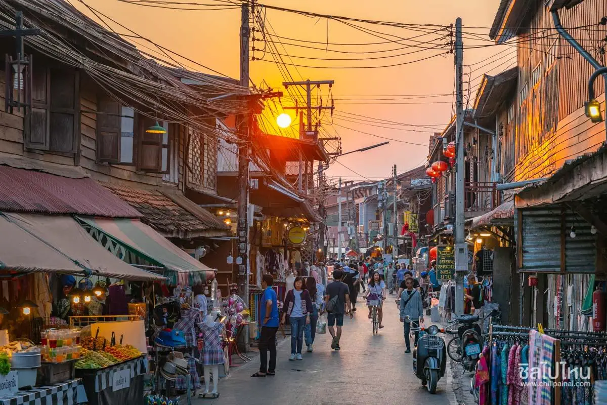
1. Chiang Khan Old Town lies along the Mekong River in Chiang Khan District. It is a compact historic town distinguished by traditional wooden houses, old shophouses, Chai Khong Road, temples, and a community lifestyle that remains closely connected with the river. Chiang Khan is not defined by monumental architecture; its appeal comes from the atmosphere, the slow rhythm of everyday life, and the opportunity to experience the Mekong at a pace very different from a large city.
Highlight: Traditional wooden houses, Chiang Khan Walking Street, Chai Khong Road, the riverside cycling route, morning merit-making and local life, historic temples, cafés, local restaurants, handicrafts, and views across the Mekong River toward Laos.
The historic district of Chiang Khan contains rows of wooden houses and shophouses lining the streets. Many are decades old and reflect the architecture of former Mekong trading communities. Some remain private homes, while others have been adapted into guesthouses, cafés, restaurants, souvenir shops, and creative spaces while preserving their original timber structures and atmosphere.
The Mekong River has always been at the heart of Chiang Khan. In the past, it served as a transportation and trading route, a source of food, and a corridor connecting communities on both sides of the river. Today, the riverside has been developed for walking and cycling, allowing visitors to see Laos, river traffic, and mountain ranges stretching behind the opposite bank.
In the evening, Chiang Khan Walking Street reveals another side of the town. Shops sell local food, souvenirs, clothing, handmade products, and community goods. The atmosphere generally becomes livelier from late afternoon into the evening, although Chiang Khan is worth exploring at other times as well. Morning and daytime are often better for appreciating the architecture and observing everyday community life in greater detail.
Chiang Khan is suitable for couples, families, older travelers, photographers, cyclists, and anyone who enjoys slow travel. Staying at least 1 night is highly recommended because a day trip misses much of the early-morning and evening atmosphere that gives the town its strongest character.
Chiang Khan can easily be combined with Kaeng Khut Khu, Phu Thok, Wat Si Khun Mueang, Wat Tha Khaek, and Wat Phra Phutthabat Phu Khwai Ngoen. Staying in Chiang Khan for 1–2 nights makes it easy to use the town as a base for exploring surrounding attractions.
Getting There: Chiang Khan is approximately 47 kilometers from Loei city. A private car is the most convenient option. Once inside the historic district, visitors should park in designated areas and continue on foot or by bicycle. The old-town area can be visited throughout the day, while the walking street generally operates around 17.00–22.00.
Map (GPS): https://www.google.com/maps/dir/?api=1&destination=17.893095,101.659000&travelmode=driving
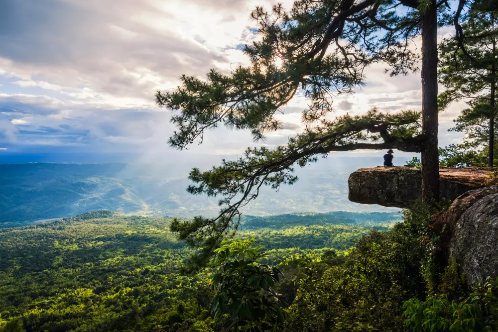
2. Phu Kradueng National Park is located in Si Than Subdistrict, Phu Kradueng District. It is one of Thailand’s most famous national parks and a classic destination for travelers who want to reach a mountain summit on foot. Phu Kradueng is a massive sandstone table mountain with a broad plateau at the top, covered by pine forest, grassland, waterfalls, ponds, and numerous cliff viewpoints.
Highlight: The hiking route through the various “Sam” rest points, Lang Pae, Wang Kwang Visitor Center, Pha Nok Aen, Pha Lom Sak, Pha Mak Duk, Sa Anodat, waterfalls, pine forest, and the iconic experience of becoming a “Phu Kradueng Conqueror.”
The ascent is itself a major part of the experience. Along the way, hikers pass several rest areas known locally as “Sam,” including Sam Haek, Sam Bon, Sam Kok Kok, Sam Kok Wa, and Sam Khrae. These stops allow visitors to rest, refill water, and pace themselves before reaching Lang Pae, the point where the steep climbing section gives way to the flatter upper plateau.
After reaching the top, hikers still need to continue toward Wang Kwang Visitor Center and other attractions. Distances across the plateau are substantial, so proper physical preparation and footwear are essential. Pha Nok Aen is a popular sunrise viewpoint, while Pha Lom Sak is one of Thailand’s most famous sunset locations, recognized by its lone pine tree and dramatic rock ledge.
Phu Kradueng supports a wide variety of ecosystems due to differences in elevation and terrain, including evergreen forest, dry dipterocarp forest, montane pine forest, grassland, and wetland areas. Seasonal plants and scenery change throughout the year, with the cool season offering particularly comfortable conditions for walking and nature observation.
The park is best suited to physically fit travelers, hikers, groups of friends, couples, and anyone looking for a demanding outdoor experience. The distance should not be underestimated. Bring sufficient water, rain protection or warm clothing depending on the season, personal medication, and keep luggage as light as possible.
The park’s tourism season runs from October 1 to May 31 each year, while the area closes for natural rehabilitation from June 1 to September 30. Travelers planning to climb should always check the latest park announcements, visitor quotas, and current regulations before traveling.
Getting There: The park is located in Si Than Subdistrict, Phu Kradueng District. Visitors can travel by private car or public transport to Phu Kradueng District and continue by local transport to the visitor center. The visitor center generally operates from 07.00–16.00, while the final permitted time to begin the climb is usually in the early afternoon.
Map (GPS): https://www.google.com/maps/dir/?api=1&destination=16.902342,101.752385&travelmode=driving
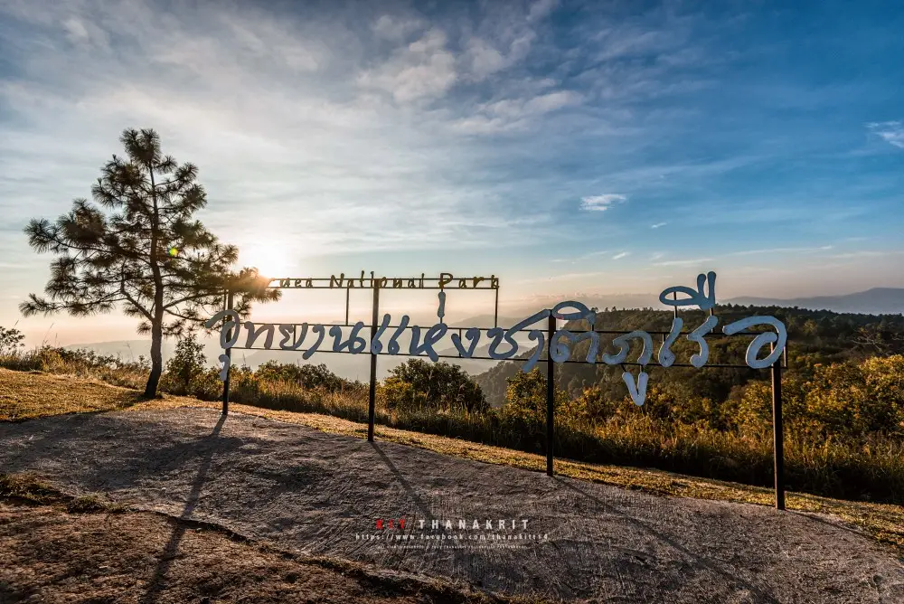
3. Phu Ruea National Park is located in Nong Bua Subdistrict, Phu Ruea District, with the protected area extending into Tha Li District. It is one of Northeastern Thailand’s best-known winter destinations, with a summit approximately 1,365 meters above sea level, cool temperatures, rock platforms, pine forests, grasslands, waterfalls, and sunrise viewpoints overlooking layers of surrounding mountains.
Highlight: Phu Ruea summit, sunrise views, sea of mist during suitable conditions, pine forest, rock platforms, unusual rock formations, extremely cool winter temperatures, and the possibility of seeing frost when temperatures fall sufficiently low.
The name “Phu Ruea” comes from sections of the mountain that resemble the bow of a ship or a large junk extending from the ridgeline. Combined with broad rock platforms and elevated viewpoints, this gives the mountain a recognizable landscape unlike other peaks in the province.
The park covers approximately 121 square kilometers and includes sandstone and granite mountains, summit plateaus, pine forest, grasslands, montane evergreen forest, and streams descending toward lower areas. This diversity allows visitors to experience several types of natural scenery within a single national park.
Winter is the most popular season because visitors can experience low temperatures and watch sunrise in very cool conditions. When temperature and humidity are suitable, frost may form on grass and plants. Other seasons are still suitable for nature trips, although the atmosphere differs considerably from the winter experience.
Phu Ruea is suitable for families, couples, older travelers, photographers, and anyone who wants mountain scenery without the strenuous ascent required at Phu Kradueng. Roads reach much higher into the park, making it a more accessible choice for visitors seeking cool weather and elevated views.
The park can easily be combined with Phra That Si Song Rak, Wat Neramit Wipatsana, and Dan Sai because the Phu Ruea–Dan Sai route forms a convenient travel zone. A 1–2 day itinerary can therefore combine nature, history, and Buddhist heritage.
Getting There: From Loei city, follow the route toward Phu Ruea District. A private car is the most convenient option. The park is open daily from 05.00–20.00. During the cool season, leave early if you want to reach the viewpoint before sunrise and bring adequate warm clothing.
Map (GPS): https://www.google.com/maps/dir/?api=1&destination=17.514187,101.344891&travelmode=driving
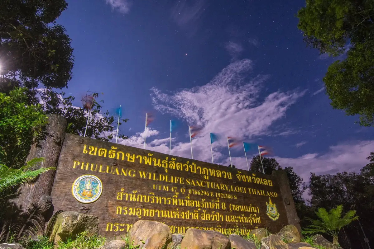
4. Phu Luang Wildlife Sanctuary is a large protected area extending across several districts of Loei Province, including Wang Saphung, Phu Ruea, Dan Sai, and Phu Luang. The name “Phu Luang” refers to a great or important mountain. The sanctuary is distinguished by high-elevation forests, rock platforms, cliffs, grasslands, pine forests, montane evergreen forest, wild orchids, and plant species adapted to cool mountain conditions.
Highlight: Khok Nok Kraba Wildlife Protection Unit, nature-study trails, pine forest, grasslands, rock platforms, wild orchids, rhododendrons, highland plants, and ecosystems that change noticeably with the seasons.
Phu Luang was declared a wildlife sanctuary on December 18, 1974. Its primary purpose is the conservation of wildlife, forests, and natural ecosystems. Tourism here therefore differs from ordinary national parks, and access for nature study is controlled according to season and regulations established by conservation authorities.
The landscape was shaped by uplift and long-term erosion, creating mountains, cliffs, rock platforms, and high plateaus at several elevations. The altitude and humidity give Phu Luang a cooler climate than the surrounding lowlands and support plant species that require specific environmental conditions.
One of the sanctuary’s greatest attractions is the seasonal transformation of plant life. Along nature trails, visitors may encounter mosses, ferns, orchids, flowering plants, and different forest types according to elevation, making Phu Luang particularly valuable for travelers interested in botany, ecology, and nature photography.
Phu Luang is best suited to nature enthusiasts, students, researchers, photographers, and visitors interested in genuine highland forest experiences rather than simple sightseeing. Stay on designated trails, keep noise to a minimum, do not remove plants or natural objects, and never disturb wildlife.
Access is controlled by seasonal announcements. One example of an officially scheduled nature-study period at Khok Nok Kraba was November 1, 2025 to April 30, 2026. Visitors should therefore check the most recent sanctuary announcement before every trip.
Getting There: The main access point for nature study is around the Khok Nok Kraba Wildlife Protection Unit. Mountain roads require a vehicle in good condition. During the referenced seasonal period, visitors were generally allowed to enter around 08.30–15.00 and were required to leave the area by 16.00.
Map (GPS): https://www.google.com/maps/dir/?api=1&destination=17.281720,101.559701&travelmode=driving
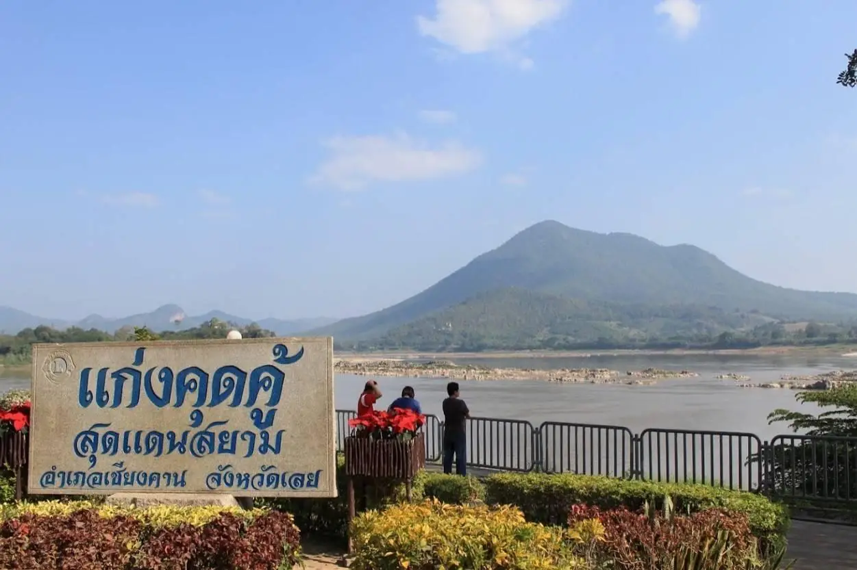
5. Kaeng Khut Khu is located at Ban Noi, Village No. 4, Chiang Khan Subdistrict, Chiang Khan District, only around 3–4 kilometers from the historic town. It is a large rocky rapid in the Mekong River with mountains in Laos forming the background and is one of the best places to understand the river landscape of the Chiang Khan area.
Highlight: Rock formations in the Mekong River, sandbars exposed during low-water periods, viewpoints, Mekong boat trips, local restaurants, and coconut candy, one of Chiang Khan’s best-known souvenirs.
Kaeng Khut Khu was formed by large rock formations in the river that have been eroded by the current over long periods. During high water, much of the rock is submerged, while in the dry season falling river levels reveal rocks, sandbanks, and islands more clearly.
February to May is generally the best period for seeing the rocky formations because water levels are lower. Visitors can relax at the viewpoint, look across toward Laos, and watch the Mekong flow through the curved river landscape around Chiang Khan.
The surrounding area has restaurants, drink stalls, and souvenir shops, making the attraction suitable for families and older travelers who prefer easy sightseeing without extensive walking. Boat trips are also available at certain times for visitors who want a closer experience of the Mekong.
Coconut candy has long been associated with Kaeng Khut Khu and is a popular souvenir for travelers returning to Chiang Khan. The attraction can also be combined with Phu Thok and Wat Phra Phutthabat Phu Khwai Ngoen in the same route.
Morning and late afternoon offer more comfortable temperatures and better light for photography than midday. Visitors should pay attention to river levels and avoid walking onto wet rocks or areas affected by strong currents.
Getting There: From Chiang Khan Old Town, follow the riverside road to Ban Noi for approximately 3–4 kilometers. Both cars and bicycles can reach the area easily. The riverside area is accessible throughout the day, while the Ban Noi Kaeng Khut Khu visitor center generally operates around 08.30–16.30.
Map (GPS): https://www.google.com/maps/dir/?api=1&destination=17.907225,101.701597&travelmode=driving
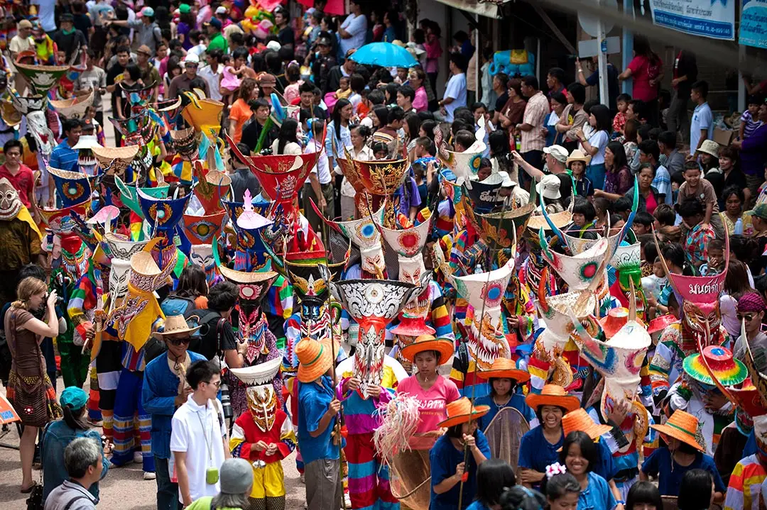
6. Phi Ta Khon Festival is held in Dan Sai District and is Loei’s most famous cultural tradition as well as one of Thailand’s best-known festivals internationally. Phi Ta Khon is not simply a colorful costume parade. It forms part of the Bun Luang festival, which combines local beliefs, Buddhist ritual, Bun Phawet traditions, rocket-festival elements, and stories from the Vessantara Jataka.
Highlight: Colorful Phi Ta Khon masks, parades through central Dan Sai, the invitation ritual for Phra Upakhut, Bun Phawet ceremonies, the procession of Prince Vessantara, Mahachat sermons, folk art made from local materials, and the strong participation of the entire community.
The story of Phi Ta Khon is linked with the Vessantara Jataka. When Prince Vessantara and Maddi returned to the city after living in the forest and completing acts of merit, animals and spirits were said to have rejoiced and followed the procession back. This story became integrated into local performance traditions and gradually developed into the distinctive festival seen in Dan Sai today.
The masks are at the heart of the celebration. They are made from locally available materials and painted in vivid colors, with faces that can appear playful, humorous, and intimidating at the same time. Costumes and accessories allow participants to dance, move, and interact energetically throughout the procession.
The festival’s deeper importance lies in community participation, from making masks and preparing rituals to organizing parades and Buddhist merit-making activities. Visitors should therefore understand Phi Ta Khon as a sacred local tradition and living community culture rather than simply a photography event.
In 2026, the festival takes place in Dan Sai, with activities centered around the district area, Kaeo Asa Road, and Wat Phon Chai according to the official program. Travelers who want to see the main procession should reserve accommodation in Dan Sai well in advance because the area becomes extremely busy during the festival.
The Phi Ta Khon Festival can be combined with Phra That Si Song Rak and Wat Neramit Wipatsana, creating an itinerary that includes tradition, religion, history, and local art within the Dan Sai area.
Getting There: Dan Sai District is approximately 80 kilometers from Loei city. Continue toward Kaeo Asa Road, Wat Phon Chai, and designated festival areas. During the festival, allow extra time for traffic and use official visitor parking areas.
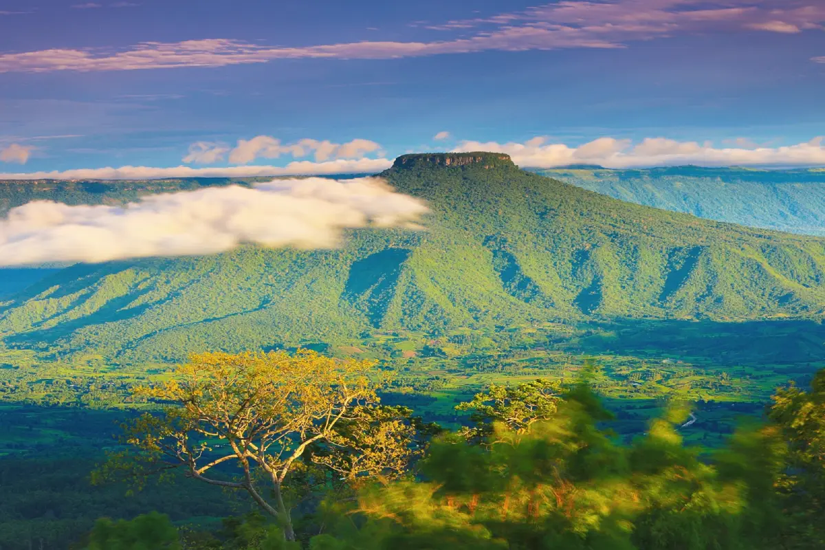
7. Phu Pa Po — Fuji of Loei is located at Ban Pha Wai, Village No. 3, Puan Phu Subdistrict, Nong Hin District. This viewpoint rises more than 900 meters above sea level and is famous for its view of “Phu Ho,” a distinctive flat-topped mountain. When a sea of mist surrounds its base, the mountain resembles Mount Fuji, giving the viewpoint its popular nickname, the “Fuji of Loei.”
Highlight: Views of Phu Ho, sea of mist, sunrise, sunset, several elevated viewpoints, extensive mountain scenery, and rides on local “E-Tak” farm vehicles to reach the viewing areas.
The main attraction of Phu Pa Po is the distant view of Phu Ho, whose distinctive flat summit rises prominently among surrounding ranges. When mist covers the lower landscape, only the upper part of Phu Ho remains visible above the clouds, creating a dramatic scene that changes from day to day.
Access to Phu Pa Po uses community-operated E-Tak vehicles, and private cars are not allowed to continue to the upper viewpoints. This system helps control traffic while directing tourism income toward local residents. Visitors ride along natural roads and stop at several viewpoints along the route.
Phu Pa Po is also an example of a formerly degraded forest landscape that has been developed into a community-based conservation attraction. Local residents manage transportation, help protect the area, and provide visitor services, linking environmental conservation directly with the local economy.
Early morning is best for travelers hoping to see sea of mist and sunrise, while late afternoon provides attractive sunset light. Temperatures at the viewpoints can be cooler and winds stronger than below, so a windbreaker is useful during the cool season.
Phu Pa Po is suitable for photographers, couples, families, and older travelers who are comfortable riding in the community E-Tak vehicles. No long-distance hike is required. It combines especially well with Suan Hin Pha Ngam, which is also located in the Nong Hin area.
Getting There: From Nong Hin District, follow the route toward Puan Phu Subdistrict and Ban Pha Wai, then follow signs for Phu Pa Po or “Kunming of Loei.” At the visitor service point, travelers must transfer to a community E-Tak vehicle. Open daily from 05.00–18.00.
Map (GPS): https://www.google.com/maps/dir/?api=1&destination=17.034009,101.711284&travelmode=driving
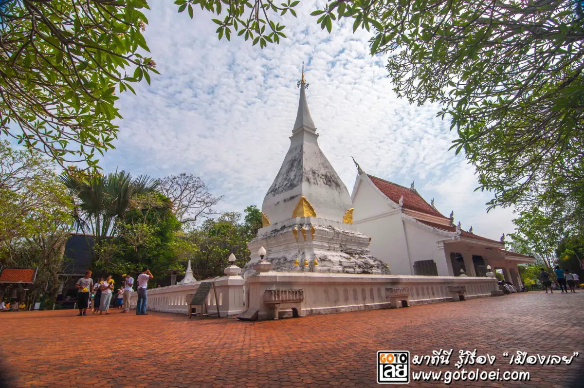
8. Phra That Si Song Rak is located beside the Man River at Ban Hua Na Yung, Dan Sai Subdistrict, Dan Sai District. It is one of Loei’s most important sacred monuments and historical landmarks. The stupa was built as a symbol of friendship and mutual commitment between the Ayutthaya Kingdom and the Kingdom of Lan Xang.
Highlight: A white Lan Xang-style stupa, mondop, Naga staircase, stone inscription, Naga-protected Buddha image, and its historical significance as a monument representing friendship between 2 kingdoms.
Construction began in 1560 and was completed in 1563 during a period of political pressure in the region. King Maha Chakkraphat of Ayutthaya and King Setthathirath of Lan Xang made an agreement not to invade each other’s territories, and Phra That Si Song Rak was created as a symbol of this relationship and mutual support.
The stupa displays Lan Xang architectural influence and is built of brick covered with plaster. Its restrained form, recessed base, and square lotus-bud style upper section reflect the architecture of the Mekong region. The white structure stands clearly against the mountain landscape and sky, giving the site a calm and sacred atmosphere.
The name “Si Song Rak” refers to the relationship and friendship between 2 parties. Many visitors therefore come to pray for love, relationships, family harmony, and unity. Its deeper historical meaning, however, is as a monument to peace and an agreement between neighboring kingdoms.
Phra That Si Song Rak remains connected with important annual traditions of Dan Sai and has specific rules of respect within the sacred area. Visitors should dress appropriately, follow local regulations, and maintain a quiet atmosphere during religious ceremonies.
The monument can be combined with Wat Neramit Wipatsana, Wat Phon Chai, and the Phi Ta Khon festival area. It is ideal for a half-day or full-day Dan Sai itinerary, particularly for travelers interested in history, culture, and religion.
Getting There: Located at Ban Hua Na Yung, Dan Sai Subdistrict, around 1 kilometer from central Dan Sai and approximately 83 kilometers from Loei city via Highways 203, 2013, and 2113. Open daily from 06.00–17.00.
Map (GPS): https://www.google.com/maps/dir/?api=1&destination=17.270074,101.140873&travelmode=driving
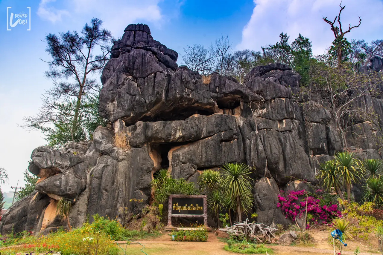
9. Suan Hin Pha Ngam — Kunming of Loei is located at Ban Pha Ngam, Village No. 10, Puan Phu Subdistrict, Nong Hin District. This natural and geological attraction is distinguished by numerous limestone formations scattered across the landscape like a giant stone garden, with cliffs, narrow passages, cavities, natural tunnels, and walking routes that sometimes feel like a natural maze.
Highlight: Unusual limestone formations, walking routes through narrow rock passages, natural cavities, viewpoints, E-Tak vehicles, a visitor center, and karst scenery that differs greatly from the sandstone mountains found in many other parts of Loei.
The landscape developed through long-term dissolution and erosion of limestone, creating openings, cracks, caves, and unusual rock forms. Trees and plants grow between the limestone formations, producing a landscape that combines rugged rock with dense greenery.
Walking routes vary in character. Some sections require visitors to pass between rocks, squeeze through narrow openings, or climb across uneven ground. This makes the experience very different from walking through an ordinary garden. Shoes with good grip are recommended, and local guides can be useful for exploring the more complicated routes.
The area also uses community E-Tak vehicles and other local visitor services, allowing travelers to experience both the natural landscape and a tourism system in which local residents participate directly. Income from these services helps connect landscape conservation with the community economy.
Suan Hin Pha Ngam is suitable for families with older children, groups of friends, nature travelers, photographers, and visitors who enjoy light to moderate adventure. Older travelers or anyone with limited mobility should select only the easier walking routes.
The attraction lies in the same tourism zone as Phu Pa Po, so visiting both in a single day is highly recommended. A good plan is to visit Phu Pa Po early for sunrise and sea of mist, then explore Suan Hin Pha Ngam later in the morning or afternoon.
Getting There: Located at Ban Pha Ngam, Village No. 10, Puan Phu Subdistrict, Nong Hin District. From Nong Hin town, continue approximately 18 kilometers along local roads. Open daily from 08.00–16.00.
Map (GPS): https://www.google.com/maps/dir/?api=1&destination=17.050645,101.743566&travelmode=driving
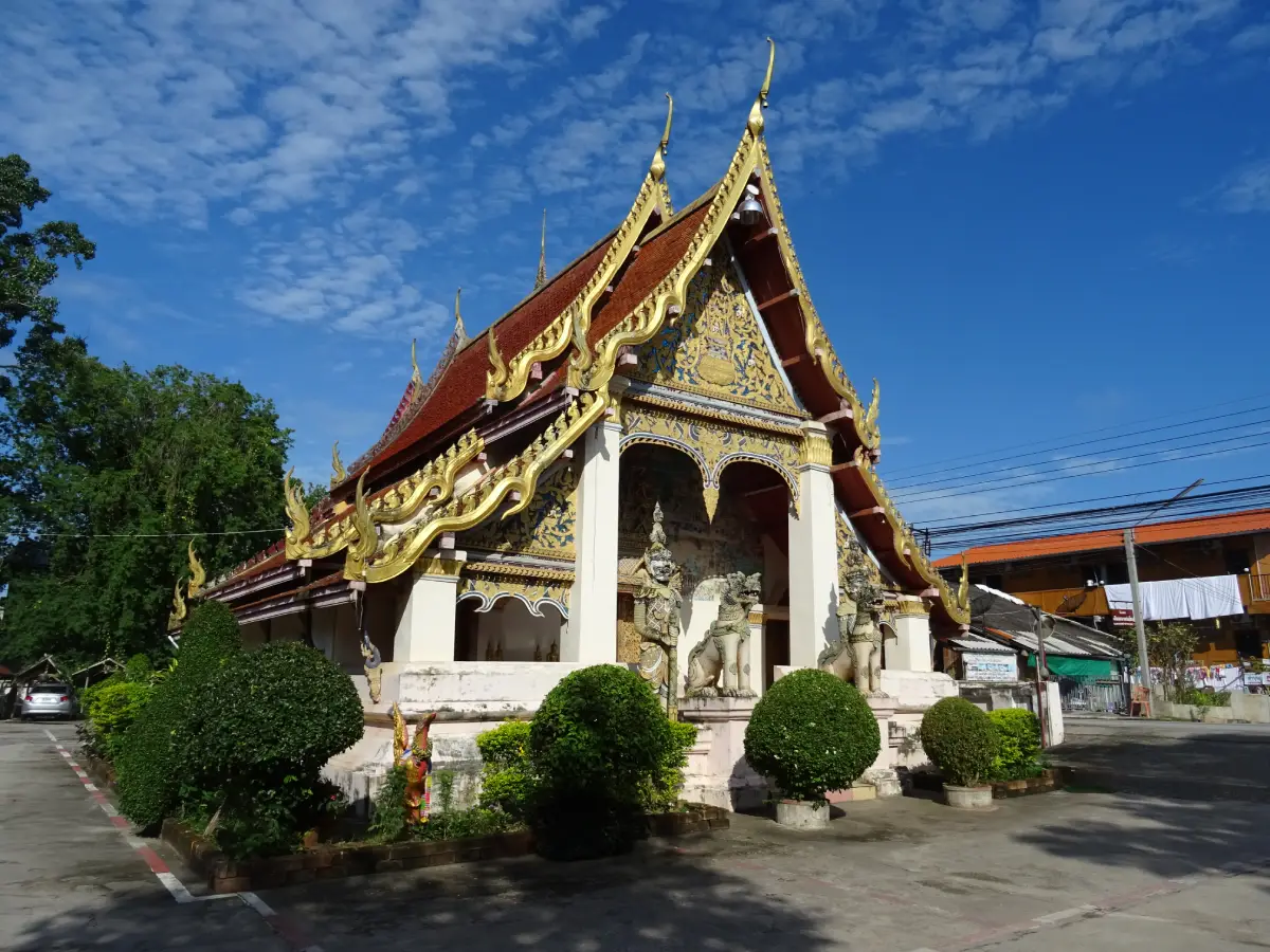
10. Wat Si Khun Mueang is located on Chai Khong Road between Soi Si Chiang Khan 6 and 7 in Chiang Khan Old Town. This historic temple helps visitors understand the religious, artistic, and cultural roots of Chiang Khan more deeply than simply walking through the wooden-house district and evening market.
Highlight: A multi-tiered ordination hall, Lanna and Lan Xang artistic influences, Jataka murals, vernacular gable decoration, carved and gilded wooden Buddha images, a carved teak preaching pulpit decorated with colored glass, a traditional water-pouring ritual structure known as a “Hang Hot,” and stone inscriptions.
Wat Si Khun Mueang is also known locally as “Wat Yai” or “Wat Yai Klang Mueang,” reflecting its long-standing role as an important spiritual center of the Chiang Khan community. Its location within the historic district demonstrates how temples and residential neighborhoods remain closely connected.
The temple’s architecture and artworks clearly show influences from Mekong River culture, including building forms, woodwork, and Lan Xang elements that connect communities on both sides of the river. Wooden Buddha images and religious objects inside the temple also reveal the craftsmanship of earlier generations.
Murals and gable decorations depict Jataka stories and Buddhist themes using colors and compositions with a distinctly local character. Unlike more formal court art, these works provide valuable evidence of the ideas, beliefs, and aesthetic preferences of the community itself.
Visitors to Chiang Khan should allow at least 30–60 minutes for the temple rather than limiting their trip to shops and the walking street. Wat Si Khun Mueang demonstrates that Chiang Khan is not simply a picturesque old town but a living community with a long and continuous cultural history.
The temple is suitable for merit-making travelers, photographers, students, art enthusiasts, and visitors who want to understand Chiang Khan culturally. Dress respectfully and avoid unnecessary contact with old religious objects or artworks.
Wat Si Khun Mueang can be explored on foot together with Chiang Khan Old Town, the walking street, Wat Tha Khaek, and the Mekong riverside, making it especially convenient for a walking itinerary through the historic district.
Getting There: Located on Chai Khong Road between Soi Si Chiang Khan 6 and Soi Si Chiang Khan 7, Chiang Khan Subdistrict, Chiang Khan District, Loei Province. Open daily from 06.00–18.00.
Map (GPS): https://www.google.com/maps/dir/?api=1&destination=17.893713,101.652400&travelmode=driving

11. Phu Thok is one of the best-known viewpoints in Chiang Khan District. Located not far from the historic town and on the same general route as Kaeng Khut Khu, Phu Thok is not as high as Phu Kradueng or Phu Ruea, but its isolated summit opens onto broad views over Chiang Khan, the Mekong River, mountain ranges in Laos, and the surrounding plains. It is therefore one of the most popular places in Chiang Khan for sunrise and sea-of-mist views.
Highlight: Morning sea of mist, sunrise, views over Chiang Khan, the Mekong River, Laos, surrounding mountains, and an elevated viewpoint that is easy to reach from Chiang Khan town.
In the Isan language, the name “Phu Thok” refers to a mountain that stands distinctly apart from the surrounding terrain. This isolated position gives the summit wide views in several directions. Although the mountain is not especially high, it offers an excellent perspective over the Chiang Khan landscape, particularly the Mekong River as it winds through the Thai–Lao border area.
Late rainy season through the cool season is the most popular time to visit because mist often settles over the lower landscape. As the sun rises above the surrounding mountains, the mist changes color and gradually reveals the river and communities below, creating ideal conditions for photography.
The upper viewpoint is relatively compact, with the Chiang Khan telecommunications station forming one of the prominent features of the summit area. Visitors should therefore use the space carefully, avoid standing too close to steep edges, and allow other travelers enough room to enjoy the view.
Phu Thok is suitable for couples, families, photographers, and travelers who want to experience sea-of-mist scenery without a long hike. Arriving before dawn also makes it easy to continue afterward to Kaeng Khut Khu, Wat Tha Khaek, Wat Phra Phutthabat Phu Khwai Ngoen, or back into Chiang Khan Old Town by late morning.
If you stay in Chiang Khan for 1 night, Phu Thok works especially well as the first activity of the following morning, allowing you to experience both the evening atmosphere of the old town and the early-morning mountain scenery without having to travel from another district before sunrise.
Getting There: Phu Thok is located in Chiang Khan District. From Chiang Khan town, travel to the lower visitor service area and use the organized shuttle service to reach the summit. Open daily from 05.00–18.00. Bring a windbreaker during the cool season and allow enough time to arrive before sunrise.
Map (GPS): https://www.google.com/maps/dir/?api=1&destination=17.869443,101.682142&travelmode=driving
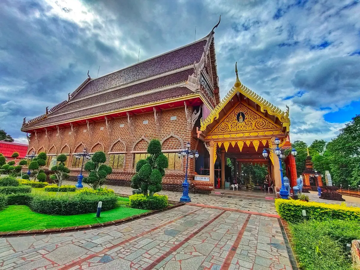
12. Wat Neramit Wipatsana is located at Ban Hua Na Yung, Dan Sai Subdistrict, Dan Sai District, on a hill not far from Phra That Si Song Rak. The temple is especially distinctive for its ordination hall and chedi built from laterite, giving the structures a warm reddish-brown color and a texture very different from more conventional Thai temples.
Highlight: Laterite ordination hall, laterite chedi, a replica of Phra Phuttha Chinnarat, large interior murals, the memorial pavilion of Luang Pho Maha Phan Silawisuttho, and a peaceful hilltop temple landscape.
The large ordination hall is the first feature that captures attention. Laterite is used as the principal construction material, giving the building its distinctive natural texture and red-brown tone. Combined with traditional Thai temple architecture, the result is both elegant and visually powerful.
Inside the ordination hall is a replica of Phra Phuttha Chinnarat as the principal Buddha image. The walls are covered with murals depicting the life of the Buddha, local life, and Buddhist narratives, allowing visitors to combine worship with an appreciation of religious art.
The temple is closely associated with Phra Khru Phawana Wisutthiyan, also known as Luang Pho Maha Phan Silawisuttho, who played an important role in founding and developing the temple. A memorial pavilion allows disciples and Buddhist visitors to pay respect, giving the temple significance not only for architecture but also for local religious devotion.
The temple grounds include open courtyards, gardens, and quiet areas suitable for merit-making, families, older travelers, photographers, and visitors interested in architecture. Morning visits offer softer light, cooler temperatures, and a more peaceful atmosphere for observing the details of the buildings.
Wat Neramit Wipatsana is best combined with Phra That Si Song Rak and central Dan Sai. During the Phi Ta Khon Festival, the temple also provides a calm contrast to the lively festival atmosphere and reveals another important side of Dan Sai.
Getting There: Located at Ban Hua Na Yung, Dan Sai Subdistrict, Dan Sai District, Loei Province. It is easily reached by car from central Dan Sai. Open daily from 06.00–18.00.
Map (GPS): https://www.google.com/maps/dir/?api=1&destination=17.263516,101.142179&travelmode=driving
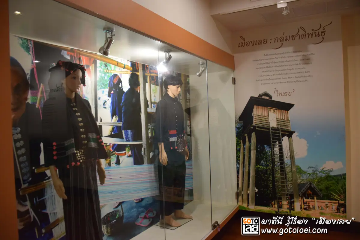
13. Loei City Museum is located inside the former Mueang Loei District Office building on Charoen Rat Road, Kut Pong Subdistrict, Mueang Loei District. The museum connects the story of Loei through its geography, urban history, ethnic communities, lifestyles, traditions, and local knowledge, making it a useful starting point before traveling to the province’s other districts.
Highlight: A historic government building with architectural value, exhibitions on the history of Loei, ethnic groups, local lifestyles, traditions, folk wisdom, and the relationship between local communities and the province’s landscape.
The building itself is historically important because it once served as the old Mueang Loei District Office. Converting the former administrative building into a museum preserves both its architecture and the collective memory of the city.
The exhibitions show that Loei is more than a province of mountains and natural attractions. It is also home to diverse communities shaped by Mekong culture, Isan traditions, folk beliefs, and settlement patterns closely connected to geography.
For travelers planning to visit Chiang Khan, Dan Sai, Phu Ruea, or the Tai Dam Cultural Village, visiting the museum first provides useful background on the people and traditions they will later encounter. It therefore adds depth to the trip beyond simply viewing scenery.
The museum is suitable for students, families, history enthusiasts, and travelers with half a day in Loei city. Around 1–2 hours is generally enough to explore the main exhibitions, after which visitors can continue to Chao Pho Kut Pong Shrine, the City Pillar Shrine, or Kut Pong Public Park.
It is also a useful indoor attraction during the hottest part of the day or when weather conditions make outdoor sightseeing less practical, giving a Loei city itinerary greater flexibility.
Getting There: Located inside the former Mueang Loei District Office building on Charoen Rat Road, Kut Pong Subdistrict, Mueang Loei District. Open Monday–Friday from 08.30–16.30.
Map (GPS): https://www.google.com/maps/dir/?api=1&destination=17.484759,101.730320&travelmode=driving
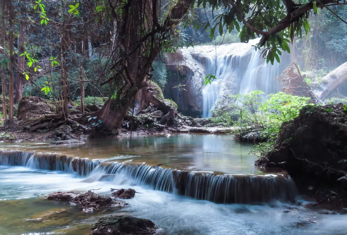
14. Than Sawan Waterfall is located at Ban Na Haeo Kao, Na Haeo Subdistrict, Na Haeo District. This natural waterfall lies close to the district center and is easier to access than many waterfalls in mountainous areas. Water falls from a height of approximately 15 meters through shaded forest into a pool below, creating a cool, humid, and peaceful environment.
Highlight: An approximately 15-meter waterfall, shaded forest, a pool at the base, natural rocks, streamside vegetation, and a location only around 2 kilometers from Na Haeo town.
The appeal of Than Sawan Waterfall lies in the opportunity to experience nature without a long or difficult forest trek. Visitors can use it as a relaxing stop while exploring Na Haeo District, enjoying the sound of flowing water and resting in the cool shade.
Water volume changes with the seasons. The rainy season through early cool season usually brings stronger flow and greener vegetation than the dry season, making this period especially suitable for photography and for travelers seeking a fresh forest atmosphere.
The lower area contains rocks of different sizes and wet surfaces affected by spray. Wear shoes with good traction and avoid climbing slippery rocks, particularly after heavy rain. When currents are strong, observe the waterfall from a safe area rather than entering the water.
The waterfall is suitable for families, groups of friends, nature travelers, and anyone exploring the Na Haeo route. It can be combined with other waterfalls, villages, and temples in the district for a full-day itinerary.
Na Haeo itself has a quieter rural and mountain atmosphere than Loei’s major tourism centers, making it particularly suitable for travelers who want to avoid crowds and explore a more peaceful natural area than Chiang Khan or Phu Ruea.
Getting There: Located at Ban Na Haeo Kao, Na Haeo Subdistrict, Na Haeo District, behind Na Haeo Witthaya School and around 2 kilometers from the district center. Open daily from 08.00–16.30.
Map (GPS): https://www.google.com/maps/dir/?api=1&destination=17.490701,101.059327&travelmode=driving
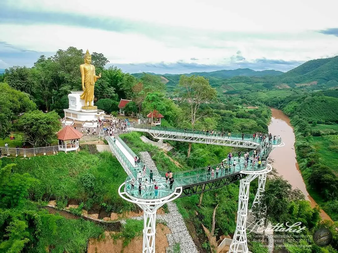
15. Phu Khok Ngio Big Buddha, formally known as Phra Phuttha Nawamin Mongkhon Lila Thawinakhara Phirak, is located at Phu Khok Ngio, Ban Tha Di Mi, Pak Tom Subdistrict, Chiang Khan District. The large golden walking Buddha stands above the point where the Hueang River meets the Mekong River, giving the site both religious significance and a striking border landscape.
Highlight: A large golden Buddha image, the confluence of the Hueang and Mekong rivers, Thai–Lao border views, mountains and riverside communities, and the Chiang Khan Skywalk or Phu Khok Ngio Skywalk within the same area.
Phu Khok Ngio provides an elevated view of 2 rivers. The Hueang River forms part of the natural border before flowing into the Mekong, helping visitors understand the relationship between mountains, rivers, and international boundaries in the Chiang Khan area.
The large Buddha image can be seen from a considerable distance. Its golden surface stands out against green mountains and open sky, creating a striking scene in both morning and afternoon light. Visitors commonly pay respect to the Buddha before continuing to the surrounding viewpoints.
The skywalk adds another elevated perspective, allowing visitors to look down toward the rivers and forest below. It is especially suitable for travelers who enjoy viewpoints and photography, although all safety regulations should be followed carefully.
Phu Khok Ngio Big Buddha is suitable for Buddhist travelers, families, couples, older visitors, and photographers. It can be visited as a half-day trip from Chiang Khan or combined with other Mekong-side attractions and the Pak Chom route.
Morning and late afternoon provide better photography light than midday. During the cool season, bring a windbreaker because the elevated viewpoint is exposed to stronger winds than the lower areas.
Getting There: From Chiang Khan town, follow the route toward Pak Tom Subdistrict and continue to Ban Tha Di Mi and Phu Khok Ngio. A private car is the most convenient option. Open daily from 06.30–18.00.
Map (GPS): https://www.google.com/maps/dir/?api=1&destination=17.820294,101.554241&travelmode=driving
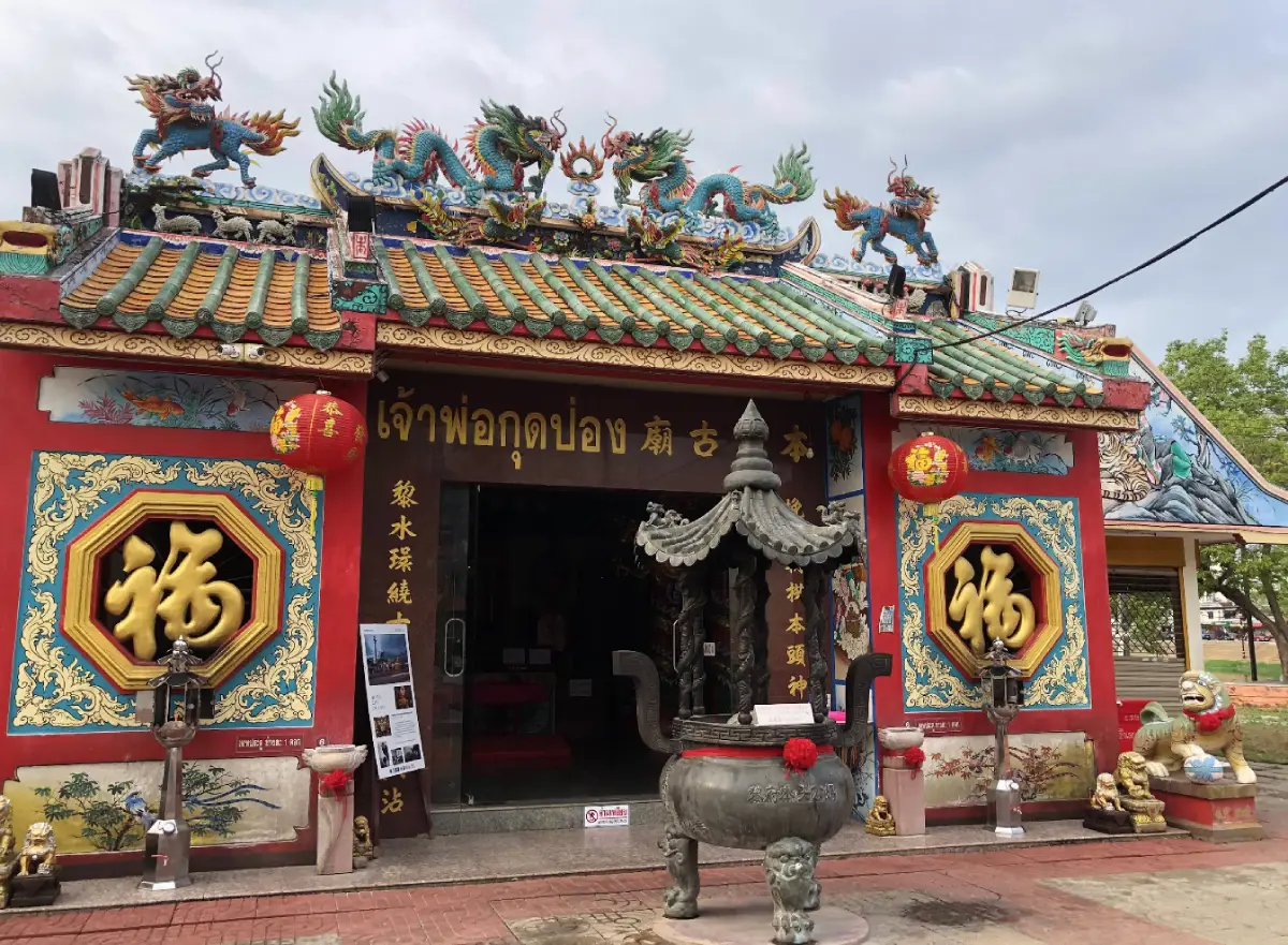
16. Chao Pho Kut Pong Shrine and Loei City Pillar Shrine are located in the heart of Loei city near the fountain roundabout and Kut Pong Public Park. The complex is an important spiritual center for local residents, bringing together both the Chao Pho Kut Pong Shrine and the City Pillar Shrine in the same area and reflecting a combination of local belief and civic identity.
Highlight: Chao Pho Kut Pong Shrine, Loei City Pillar Shrine, a golden city pillar made from golden shower wood, a central-city location, and the local custom of paying respect for good fortune before beginning a journey.
Chao Pho Kut Pong Shrine has long been respected by local residents and reflects the belief in a sacred guardian protecting the city. The City Pillar Shrine, meanwhile, symbolizes stability and the civic center of the province.
The city pillar is made from golden shower wood and finished with traditional lacquer and gold leaf. Its elegant form represents auspiciousness, stability, and prosperity. Seeing both the local guardian shrine and city pillar in one place also illustrates how folk belief and civic symbolism coexist within Loei.
Its location near the fountain roundabout and Kut Pong Public Park makes it easy to visit for travelers staying in the city. Many visitors stop here before continuing to Chiang Khan, Phu Ruea, Dan Sai, or Phu Kradueng.
The site is suitable for Buddhist and spiritual travelers, older visitors, families, and anyone interested in central Loei. It does not require much time and can be combined with Loei City Museum and Kut Pong Public Park in a half-day route.
Visitors should dress respectfully, remain quiet, and avoid disturbing people who are praying or conducting rituals because the complex continues to function as a living place of local faith.
Getting There: Located in Kut Pong Subdistrict, Mueang Loei District, around 100 meters from the fountain roundabout and adjacent to Kut Pong Public Park. Open daily from 07.30–17.00.
Map (GPS): https://www.google.com/maps/dir/?api=1&destination=17.486770,101.728985&travelmode=driving
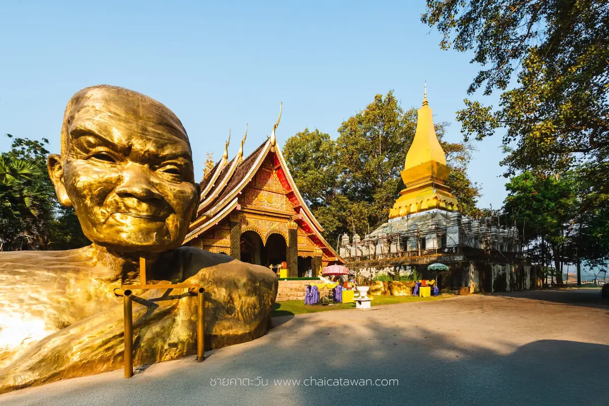
17. Wat Tha Khaek is located at Ban Noi, Village No. 4, Chiang Khan Subdistrict, Chiang Khan District, on the Mekong River before reaching Kaeng Khut Khu. This historic temple is closely connected with the history of riverside communities, Buddhism, and Lan Xang culture, making it especially valuable for visitors who want to understand Chiang Khan beyond the old-town shopping area.
Highlight: Three ancient sandstone Buddha images known as the “Three Sibling Buddhas,” a peaceful Mekong-side setting, Lan Xang historical connections, local craftsmanship, and links with the Thai forest meditation tradition.
The temple’s riverside location is historically important because the Mekong once served as a major route for transportation, trade, settlement, and the spread of Buddhism between communities on both sides of the river. Temples such as Wat Tha Khaek therefore provide strong evidence of cultural exchange throughout the Mekong basin.
The Three Sibling Buddhas are among the temple’s most important antiquities. Enshrined inside the ordination hall, these sandstone Buddha images have long been respected by the people of Chiang Khan and reflect the craftsmanship and Buddhist artistic traditions of earlier periods.
The atmosphere is noticeably quieter than Chiang Khan Walking Street, making Wat Tha Khaek a good place to pause, pay respect, and enjoy the Mekong without rushing. Morning is especially pleasant because temperatures are cooler and fewer visitors are present.
Wat Tha Khaek is suitable for Buddhist travelers, history enthusiasts, photographers, older visitors, and anyone interested in Lan Xang culture. It can easily be combined with Kaeng Khut Khu, Wat Phra Phutthabat Phu Khwai Ngoen, and Chiang Khan Old Town.
Allow around 30–60 minutes for the visit. Dress respectfully and avoid unnecessary contact with old Buddha images or antiquities to help preserve the temple’s historic objects.
Getting There: Located at Ban Noi, Village No. 4, Chiang Khan Subdistrict, Chiang Khan District, on the route before Kaeng Khut Khu. Open daily from 06.00–18.00.
Map (GPS): https://www.google.com/maps/dir/?api=1&destination=17.904879,101.683319&travelmode=driving
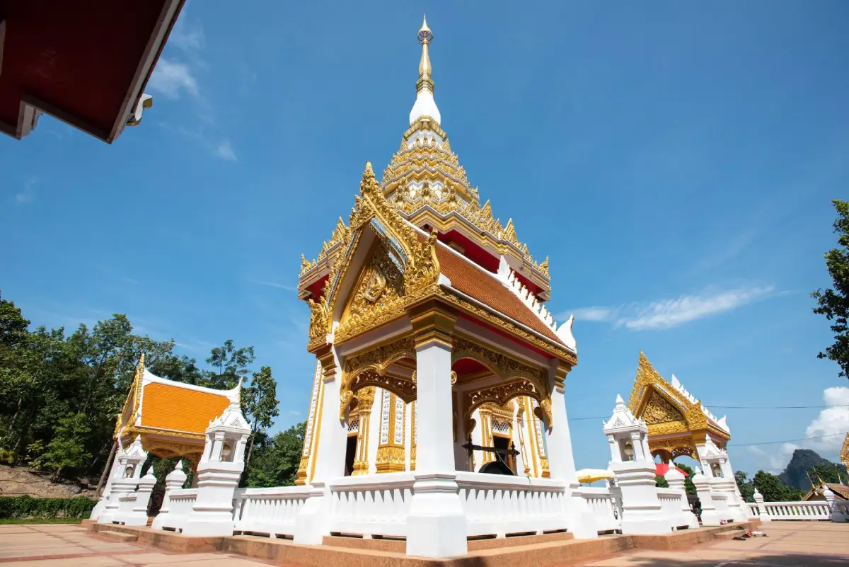
18. Wat Phra Phutthabat Phu Khwai Ngoen is located at Ban Pha Baen, Bu Hom Subdistrict, Chiang Khan District. This historic hilltop religious site centers on a sacred Buddha footprint enshrined on a natural stone platform and officially registered as an ancient monument, giving the temple religious, historical, and local cultural importance.
Highlight: A Buddha footprint approximately 120 centimeters long and 65 centimeters wide, a hilltop temple setting, the silver-buffalo statue, local beliefs, and a location that can easily be combined with Kaeng Khut Khu and Phu Thok.
The Buddha footprint is located on a stone surface locally described as sharpening stone and has long been revered by the community. It was registered as an ancient monument in 1935, making it one of the important religious heritage sites of the Chiang Khan area.
The name “Phu Khwai Ngoen,” or Silver Buffalo Mountain, is connected with local legends and beliefs, which are still represented through the silver-buffalo statue within the temple grounds. The site therefore demonstrates how geography, religion, and community storytelling can become closely connected.
The temple is quieter than Chiang Khan’s major tourist attractions and is particularly pleasant for a morning visit. Travelers can pay respect, learn about the history of the Buddha footprint, and enjoy the landscape surrounding the hill.
The site is suitable for Buddhist travelers, families, older visitors, history enthusiasts, and anyone interested in folk belief. It can be combined with Kaeng Khut Khu, Wat Tha Khaek, Phu Thok, and Phu Khok Ngio Big Buddha as part of a wider Chiang Khan route.
Visitors should dress respectfully and follow temple regulations when entering the sacred footprint area, particularly during festivals or merit-making events when larger numbers of worshippers visit.
Getting There: Located at Ban Pha Baen, Bu Hom Subdistrict, Chiang Khan District, Loei Province. Easily reached by car from Chiang Khan town. Open daily from 06.00–18.00.
Map (GPS): https://www.google.com/maps/dir/?api=1&destination=17.898381,101.750178&travelmode=driving
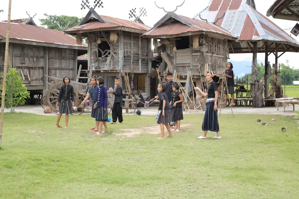
19. Tai Dam Cultural Village is located at Ban Na Pa Nat, Khao Kaeo Subdistrict, Chiang Khan District. This community of Tai Dam people continues to preserve its language, clothing, beliefs, traditions, houses, household objects, weaving, and local knowledge through everyday life rather than functioning only as a cultural display for tourists.
Highlight: Traditional Tai Dam houses, black clothing, handwoven textiles, Tum Nok Tum Nu decorative objects, local language and rituals, migration history, community life, and handicrafts made by local residents.
The Tai Dam community at Ban Na Pa Nat traces its settlement in the area to the early 20th century and has continued across several generations. This long history has allowed the community to preserve ethnic memory through language, clothing, ancestor beliefs, craftsmanship, and traditional forms of housing.
The cultural village was established as a learning space to collect and pass on community stories. Visitors can see traditional houses, tools, woven fabrics, and handicrafts while learning how each object relates to everyday life and ritual practices.
Textile weaving is one of the community’s most important forms of knowledge. Black clothing is a defining feature of Tai Dam identity, while weaving patterns and textile use vary according to occasion and the role of the wearer, making the village particularly valuable for anyone interested in textiles and ethnic studies.
The village is suitable for families, students, history enthusiasts, cultural travelers, and anyone interested in community-based tourism. Allow at least 1–2 hours, and consider buying products directly from local residents to help support the continuation of traditional knowledge.
Ban Na Pa Nat is not far from Chiang Khan and can be visited on a half-day trip before returning to the old town. It can also serve as a cultural stop between Loei city and Chiang Khan, adding greater variety to an itinerary dominated by natural attractions.
Getting There: Located at Ban Na Pa Nat, Khao Kaeo Subdistrict, Chiang Khan District, Loei Province. A private car is the most convenient option. Open daily from 08.00–17.00.
Map (GPS): https://www.google.com/maps/dir/?api=1&destination=17.797826,101.731657&travelmode=driving
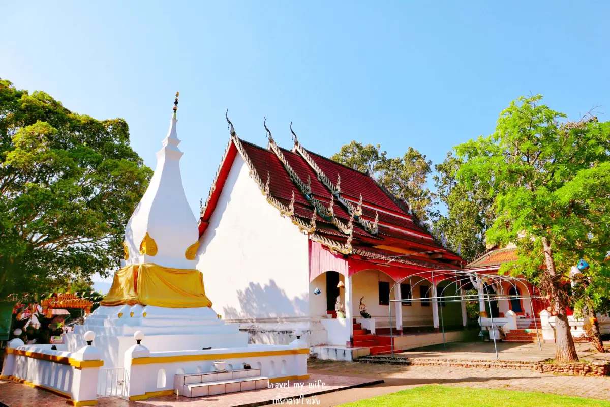
20. Wat Phon Chai, Ban Huai Khai is located in Khok Yai Subdistrict, Tha Li District. This community temple is surrounded by the rural landscape and mountain scenery of Tha Li. Its main features are the ordination hall and principal Buddha image, making it suitable for travelers who want to leave the main tourism routes and experience a quieter temple in Loei’s border countryside.
Highlight: The temple’s ordination hall, principal Buddha image, Ban Huai Khai community atmosphere, rural scenery of Tha Li District, and a peaceful setting far removed from major tourist attractions.
This Wat Phon Chai should be distinguished from the temple of the same name associated with Dan Sai. The Ban Huai Khai temple is located in Khok Yai Subdistrict, Tha Li District, and belongs to a different local community and historical context.
The ordination hall is the architectural center of the temple, with the principal Buddha image enshrined inside. The temple continues to be used for religious activities by local residents and remains an active part of community life rather than functioning purely as a tourist attraction.
The area around Ban Huai Khai consists of agricultural communities set among mountain ranges. Visiting therefore offers a very different experience from Chiang Khan or Phu Ruea and is especially suitable for travelers who prefer quiet roads and authentic local landscapes in less-visited districts.
The temple is suitable for Buddhist travelers, cultural photographers, visitors interested in community life, and anyone traveling through Tha Li District. Dress respectfully and avoid disturbing monks or residents during religious or community activities.
Including Tha Li in a Loei itinerary helps spread travel beyond the province’s best-known destinations and provides a broader view of its border communities. The temple can also serve as a peaceful stop while traveling to nearby natural or community attractions.
Getting There: Located at Ban Huai Khai, Khok Yai Subdistrict, Tha Li District, Loei Province. A private car is the most practical option. Daytime visits are recommended.
Map (GPS): https://www.google.com/maps/dir/?api=1&destination=17.274458,101.149054&travelmode=driving
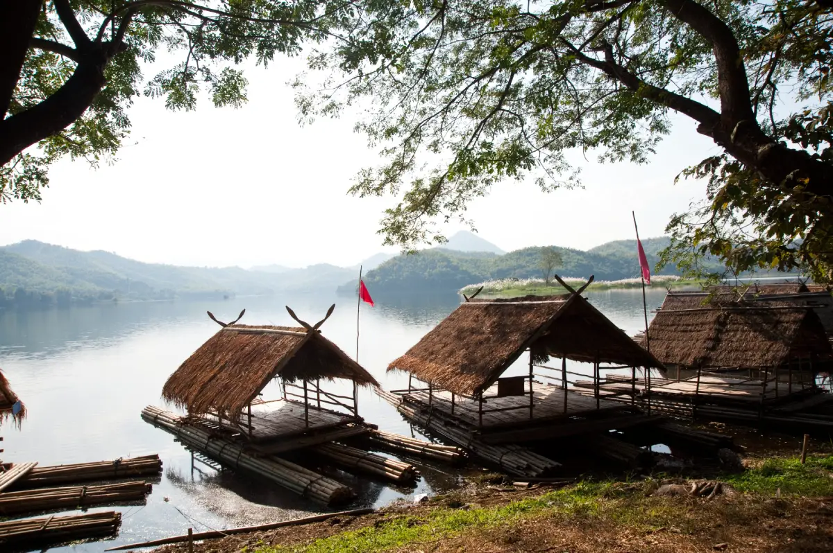
21. Huai Nam Man Lower Reservoir is located in Nam Man Subdistrict, Mueang Loei District. This medium-sized reservoir lies relatively close to Loei city and is suitable for travelers who want a break from mountain routes and major attractions to enjoy calm water, reflections of surrounding hills, and a simple natural setting.
Highlight: A broad reservoir, shaded surroundings, large trees along the water, relaxation areas, nearby local shops, photography spots, and convenient access from Loei city.
The reservoir plays an important role in water storage and supporting surrounding communities. At the same time, it has become a local recreation area, giving visitors a glimpse of another side of Loei that is not defined by high mountains or famous tourism towns but by landscapes closely connected with everyday life.
Morning and late afternoon are the best times to visit because temperatures are more comfortable and the water reflects the sky more beautifully than at midday. During the cool season, the atmosphere becomes especially pleasant for sitting, resting, and photography without demanding physical activity.
Large trees around parts of the reservoir provide shade, making it suitable for families, older travelers, couples, and anyone looking for a relaxing stop while traveling toward Chiang Khan, Phu Ruea, or Phu Luang. Around 1–2 hours is generally enough for a leisurely visit.
Huai Nam Man Lower Reservoir also adds variety to a Mueang Loei itinerary because it can be combined with Loei City Museum, the City Pillar Shrine, Kut Pong Public Park, and Phu Pha Lom Forest Park.
Visitors should help keep the area clean, avoid throwing rubbish into the reservoir or along the shoreline, and should not swim in areas without safety supervision or where water depth is unknown.
Getting There: Located in Nam Man Subdistrict, Mueang Loei District, Loei Province. A private car is the most convenient option. Open daily from 08.00–17.00.
Map (GPS): https://www.google.com/maps/dir/?api=1&destination=17.503135,101.610800&travelmode=driving

22. Kut Pong Public Park is a green urban space in central Loei, located behind Chao Pho Kut Pong Shrine and the City Pillar Shrine. The park contains ponds, canals, bridges, walking paths, large trees, and exercise areas, making it a good place to observe everyday life in Loei city in a calm and relaxed atmosphere.
Highlight: Ponds and waterways, green spaces, connecting bridges, exercise paths, trees and flowers, relaxation areas, and a location directly connected with Chao Pho Kut Pong Shrine and the City Pillar Shrine.
The attraction of the park does not come from being a major landmark, but from functioning as a public space genuinely used by local residents. In the morning, people come to walk and exercise, while the evening atmosphere becomes more relaxed and is especially pleasant after a full day of sightseeing.
The combination of water and greenery in the city center creates a slower and more comfortable atmosphere. Visitors can also see how sacred sites, public green spaces, and the old urban district are all located within easy walking distance of one another.
Kut Pong Public Park is suitable for families, older travelers, runners, urban photographers, and anyone staying in the municipality. It can be used as a convenient rest stop between Loei City Museum and the City Pillar Shrine without having to drive outside the city.
If you have only half a day in Loei city, a practical route is to begin at Loei City Museum, continue to Chao Pho Kut Pong Shrine and the City Pillar Shrine, and then walk through Kut Pong Public Park. This combines city history, faith, and local urban life in a single compact area.
Late afternoon and evening are the most pleasant times for walking, particularly during the cool season when temperatures in Loei city can feel noticeably more comfortable than in many other parts of Northeastern Thailand.
Getting There: Located behind Chao Pho Kut Pong Shrine in Kut Pong Subdistrict, Mueang Loei District, Loei Province. Open daily from 06.00–18.00.
Map (GPS): https://www.google.com/maps/dir/?api=1&destination=17.485568,101.729388&travelmode=driving

23. Ban Kang Pla Tai Loei Weaving Group is located at Ban Kang Pla, Chaiyaphruek Subdistrict, Mueang Loei District. This community learning center presents local textile knowledge through yarn, color, patterns, and the skills of village weavers. It is especially suitable for travelers interested in handicrafts and for those who want to buy locally made products directly from the producers.
Highlight: Traditional loom weaving, Tai Loei textiles, clothing, pha khao ma cloths, bags, textile-based household products, weaving demonstrations, and opportunities to purchase community-made products.
The weaving tradition of Ban Kang Pla grew from household life, when families produced clothing for their own use. In the past, cotton was cultivated, spun into yarn, and woven into cloth for everyday wear, merit-making events, and traditional ceremonies. Over time, this knowledge developed into organized community production.
Visiting a working weaving community helps travelers understand that a finished textile does not begin in a shop. It requires preparing yarn, selecting colors, planning patterns, setting up the loom, and weaving thread by thread. Seeing these stages directly makes the labor, skill, and time behind each piece much easier to appreciate.
Products include fabric lengths, men’s shirts, women’s clothing, pha khao ma, bags, and practical household items adapted from handwoven textiles. This makes the group a particularly good place to buy souvenirs with a clear local story while supporting community income directly.
The site is suitable for students, designers, fashion and textile enthusiasts, international visitors, and travelers who want a deeper understanding of Tai Loei culture through tangible craftsmanship.
It can be combined with Loei city, Ban Na O, or the Wat Si Chan Folk Museum to create a cultural route connecting community history, traditional household objects, and weaving knowledge.
Getting There: Located at Ban Kang Pla, Chaiyaphruek Subdistrict, Mueang Loei District, Loei Province. Open daily from 08.00–18.00.
Map (GPS): https://www.google.com/maps/dir/?api=1&destination=17.529288,101.737446&travelmode=driving
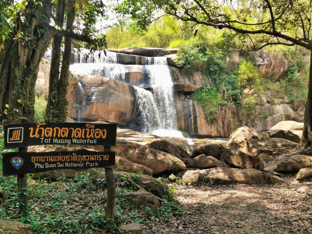
24. Tat Hueang Waterfall (Thai–Lao Waterfall) is located near Ban Bo Mueang Noi, Saeng Pha Subdistrict, Na Haeo District. This large waterfall lies on the Hueang River in the Thai–Lao border area and is one of the major natural attractions of Phu Suan Sai National Park.
Highlight: A large waterfall, the Hueang River, Thai–Lao border geography, dense mountain forest, powerful rainy-season flow, and a remote natural atmosphere very different from Loei’s more famous tourist areas.
The waterfall is also known as the “Thai–Lao Friendship Waterfall” because the Hueang River is connected with the natural border between the 2 countries. Its appeal therefore comes not only from the waterfall itself but also from the geography that gives the site a distinctive international-border context.
The rainy season and the period immediately afterward are when the waterfall is most powerful. Water rushes across cliffs and rock layers surrounded by dense forest, producing spray and a cool, humid atmosphere that is especially attractive from safe viewpoints.
Because Tat Hueang is a large waterfall in a forest environment, visitors should avoid approaching cliff edges or strong currents, particularly after heavy rain. Warning signs and instructions from park staff should always be followed carefully.
Tat Hueang is suitable for nature travelers, photographers, groups of friends, and visitors looking for a quieter border-area destination. It can be combined with Khring Waterfall, Than Sawan Waterfall, and other Na Haeo attractions in a 1–2 day itinerary.
Na Haeo is relatively far from Loei city, so staying overnight in the district reduces long driving periods and allows more time to explore forests, waterfalls, and local communities.
Getting There: Located near Ban Bo Mueang Noi, Saeng Pha Subdistrict, Na Haeo District, approximately 25 kilometers from the district center. Open daily from 08.00–17.00. Check weather conditions before traveling during the rainy season.
Map (GPS): https://www.google.com/maps/dir/?api=1&destination=17.563944,100.991420&travelmode=driving
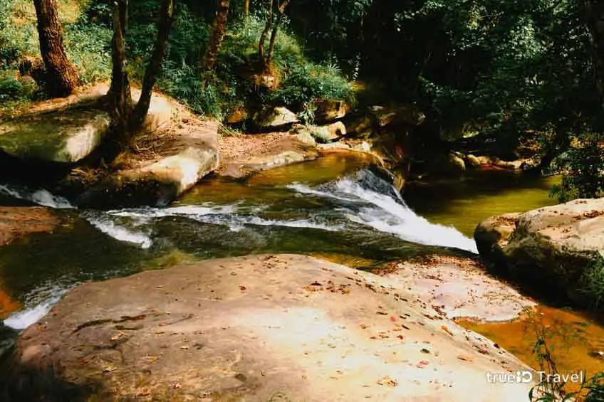
25. Khring Waterfall is located in Saeng Pha Subdistrict, Na Haeo District, near the Mueang Phrae–Rom Klao Road. This waterfall is formed by a stream flowing over a sequence of natural rocks and small cascades surrounded by lush vegetation. It offers a quieter atmosphere than larger waterfalls and is especially suitable for relaxed nature stops.
Highlight: A stream flowing over natural rocks, pools below the cascades, streamside forest, rest pavilions, shaded surroundings, and a location that connects conveniently with attractions in Phu Suan Sai National Park.
Khring Waterfall differs from Tat Hueang because it is not defined by one large cliff. Instead, water descends across multiple rocky levels, allowing visitors to observe the stream and its surrounding ecosystem at closer range.
Dense vegetation grows along the watercourse, helping keep the area cool and humid, particularly during the rainy season and early cool season. At this time, the forest is greener and water flow is generally stronger than during the dry season.
The lower area contains pools and places to rest, making it suitable for families and groups of friends exploring Na Haeo. Visitors should still be cautious around slippery rocks and avoid entering the water when the current is strong.
Khring Waterfall is ideal for travelers who enjoy uncomplicated nature, photography, and learning about the variety of water systems within the Phu Suan Sai area. It can be used as a stop between Than Sawan Waterfall and Tat Hueang Waterfall.
A Na Haeo itinerary is best planned as at least a full day because attractions are distributed across mountain and rural roads. Avoiding a rushed schedule improves both safety and the overall experience.
Getting There: Located in Saeng Pha Subdistrict, Na Haeo District, Loei Province, near the Mueang Phrae–Rom Klao Road. Open daily from 07.00–18.00.
Map (GPS): https://www.google.com/maps/dir/?api=1&destination=17.474650,100.975740&travelmode=driving
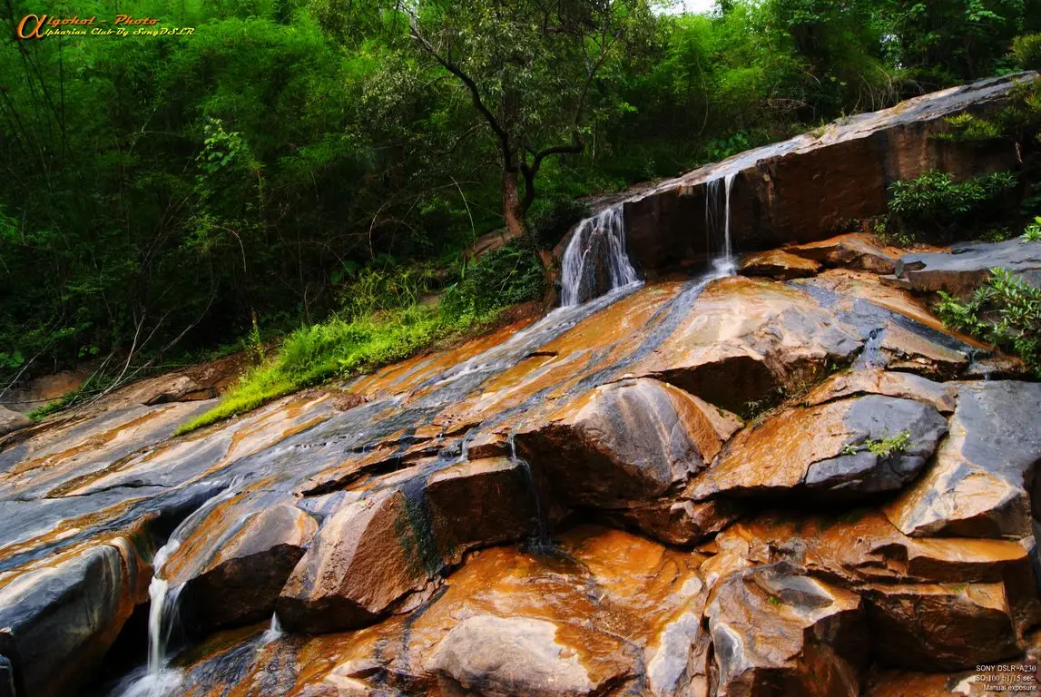
26. Kaeng Song Khon Waterfall is located at Ban Hua Na Yung, Dan Sai Subdistrict, Dan Sai District. This natural attraction consists of a broad stream flowing across numerous rocks and descending gradually under the shade of large trees. It is a useful addition to a Dan Sai itinerary for travelers who want nature alongside temples and cultural attractions.
Highlight: A broad stream, natural rapids and rocks, shaded forest, the sound of flowing water, and a peaceful atmosphere around Ban Hua Na Yung.
This is not a high cliff waterfall. Its beauty comes from water moving gradually over multiple rock layers and small rapids, creating a landscape that blends naturally with the surrounding forest and is better suited to relaxation than dramatic waterfall viewing.
The rainy season is when the rapids and current are most visible, and vegetation around the stream becomes particularly lush. However, water levels can also change quickly, so caution is necessary during periods of continuous rainfall upstream.
The attraction is suitable for families, groups of friends, and nature travelers staying in Dan Sai. It can be used as a relaxing stop after visiting Phra That Si Song Rak or Wat Neramit Wipatsana.
Visitors should choose stable places to sit, avoid stepping on algae-covered rocks, and stay out of the current when water levels are high, particularly during the rainy season when the rocks become significantly more slippery.
Including Kaeng Song Khon in a Dan Sai itinerary helps show that the district is not defined only by the Phi Ta Khon Festival and religious monuments. Streams, forests, and mountains are also important parts of its natural landscape.
Getting There: Located at Ban Hua Na Yung, Dan Sai Subdistrict, Dan Sai District, Loei Province. Access depends on seasonal conditions. Daytime visits are recommended, and water conditions should be checked before traveling.
Map (GPS): https://www.google.com/maps/dir/?api=1&destination=17.254002,101.141103&travelmode=driving
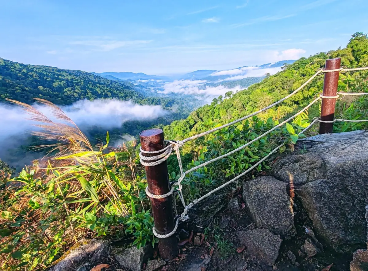
27. Phu Sawan is a mountain viewpoint on the Phu Lom Lo route in Kok Sathon Subdistrict, Dan Sai District. It is distinguished by high mountain scenery, sea of mist, agricultural landscapes, and fields of wild Himalayan cherry trees that turn parts of the mountainsides pink during the flowering season.
Highlight: Mountain viewpoints, sea of mist, the Phu Lom Lo route, wild Himalayan cherry blossoms during the cool season, views toward Ban Man Khao, and mountain landscapes around the meeting area of Loei, Phetchabun, and Phitsanulok provinces.
Phu Sawan is not centered on major buildings or monuments. Its appeal comes from being a scenic stop along a high-mountain route. When the wild Himalayan cherry trees bloom, entire sections of the landscape become covered in shades of light and deep pink against the surrounding forest.
The flowering period varies each year because it depends on temperature, cold conditions, and local weather. Travelers planning a trip specifically to see the blossoms should check current flowering conditions before departure.
Travel within the Phu Lom Lo area uses community-operated transport from designated service points. This reduces the number of private vehicles on mountain roads and directs tourism income toward Kok Sathon community. Visitors should follow shuttle schedules and drivers’ instructions.
Even outside the blossom season, Phu Sawan remains valuable for its mountain views and cool winter climate. It is especially suitable for photographers, couples, groups of friends, and travelers who want to see the continuous mountain landscape connecting upper Isan with the lower North.
Morning offers the best chance of mist and softer light, while late morning and afternoon provide clearer views of the mountain ranges. Bring warm clothing and a windbreaker during the cool season because temperatures at elevation are considerably lower than on the plains.
Getting There: Located on the Phu Lom Lo route in Kok Sathon Subdistrict, Dan Sai District, Loei Province. Access operates according to seasonal conditions and local announcements. Community vehicles generally run approximately from 05.00–16.00.
Map (GPS): https://www.google.com/maps/dir/?api=1&destination=17.484252,101.653632&travelmode=driving
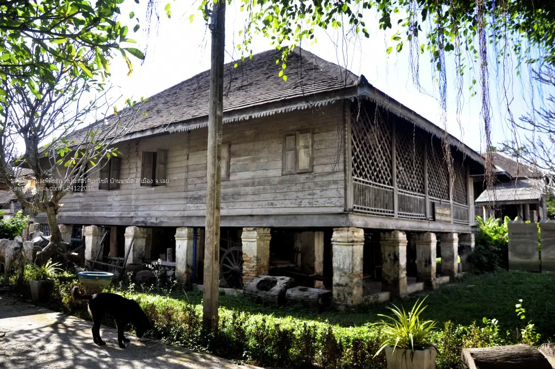
28. Wat Si Chan Folk Museum is located inside Wat Si Chan at Ban Na O, Na O Subdistrict, Mueang Loei District. This community museum preserves tools, household objects, and artifacts that reflect the traditional life of Tai Loei people, including stories connected with religion, occupations, and local customs of Ban Na O.
Highlight: Agricultural tools, household objects, religious items, folk artifacts, community traditions, and the context of Wat Si Chan as both a religious center and learning space for Ban Na O.
The museum is particularly interesting because its objects remain closely connected with the community that created and used them. They are not separated from local life in the way objects sometimes are in larger museums. Each item helps explain how earlier generations worked, earned a living, and organized daily life.
Ban Na O has strong Tai Loei cultural roots, and a visit to the museum helps explain how local knowledge developed in response to landscape, climate, agriculture, and belief systems.
Tak Bat Devo is one of the community’s important Buddhist traditions and demonstrates the continuing role of the temple as a space connecting households, religion, and local customs.
The museum is suitable for students, historians, anthropologists, cultural travelers, and visitors who want to understand Loei through community life rather than only through scenic attractions.
Because this is a compact community museum and access depends on temple caretakers, visitors should contact the site in advance to make sure the exhibition areas are available during the planned visit.
Getting There: Located inside Wat Si Chan on the Loei–Chiang Khan road at Ban Na O, Na O Subdistrict, Mueang Loei District, Loei Province. Advance contact is recommended before visiting.
Map (GPS): https://www.google.com/maps/dir/?api=1&destination=17.583884,101.729162&travelmode=driving
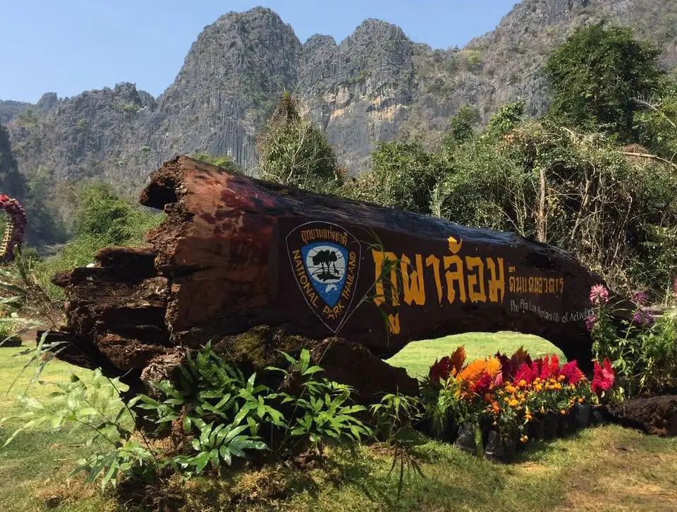
29. Phu Pha Lom Forest Park is located at Ban Phia, Nam Suai Subdistrict, Mueang Loei District, around 24 kilometers from Loei city. This natural area is characterized by steep limestone and granite mountain ranges that surround the interior landscape like natural walls, with forest, caves, seepage springs, and nature-study routes inside.
Highlight: Jagged limestone mountains, high cliffs, dry evergreen forest, mixed deciduous forest, caves, natural springs, local medicinal plants, valley-floor areas, and nature-study trails.
The name “Phu Pha Lom” reflects the surrounding mountain landscape. From outside, the high rock formations resemble a natural wall, while entering the interior reveals more humid forest and flatter areas, creating a noticeable contrast in scenery.
The area ranges from approximately 400–700 meters above sea level and contains several forest types, supporting medicinal plants, native vegetation, and ecosystems that vary according to altitude and underlying geology.
Phu Pha Lom was declared a forest park on March 15, 1996 and covers approximately 8,500 rai. It serves both conservation purposes and as an accessible nature-learning area relatively close to Loei city.
The forest park is suitable for light to moderate hikers, students, photographers, and geology enthusiasts. Wear shoes suitable for natural trails and remain on designated routes.
It can be combined with Huai Nam Man Lower Reservoir and attractions in Loei city, creating a day trip that includes mountains, forest, water landscapes, and urban history without requiring travel across several distant districts.
Getting There: Located at Ban Phia, Nam Suai Subdistrict, Mueang Loei District, Loei Province, approximately 24 kilometers from the city. Open daily from 08.00–17.00.
Map (GPS): https://www.google.com/maps/dir/?api=1&destination=17.554228,101.868867&travelmode=driving
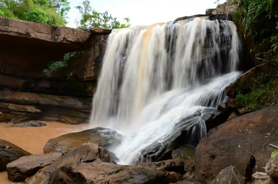
30. Pla Ba Waterfall (Tat San Waterfall) is located in Pla Ba Subdistrict, Phu Ruea District, around Ban Tat San and Ban Pla Ba. This natural waterfall spreads across a broad rock platform before descending into a pool below, giving it a different appearance from waterfalls that drop in a single narrow stream from a high cliff.
Highlight: A broad rock platform, water spreading across several levels, an approximately 10-meter waterfall, a pool below, shaded forest, and a location within a mountain community in Phu Ruea District.
The waterfall is created by changes in elevation along the San stream. Water spreads across the stone surface before dropping to a lower level, allowing visitors to see rock layers, flowing water, and forest together in a broad open landscape.
The pool below is suitable for relaxation when water conditions are safe, while forest around the waterfall provides shade and helps keep the area cooler. It works especially well as a late-morning or afternoon stop after an early visit to Phu Ruea National Park.
The rainy season through early cool season brings the strongest flow. During the dry season, water volume can decrease considerably, so travelers should consider both season and weather conditions before visiting.
Pla Ba Waterfall is suitable for families, groups of friends, and nature travelers who do not want a demanding hike. Rock surfaces can become slippery, however, so extra caution is necessary after rain.
The waterfall can be combined with Phu Ruea National Park, local flower and ornamental-plant areas, and other Phu Ruea attractions, creating a day that includes sunrise on the mountain, cool weather, community landscapes, and a natural waterfall.
Getting There: Located in Pla Ba Subdistrict, Phu Ruea District, Loei Province, around Ban Tat San–Ban Pla Ba. Open daily from 08.00–17.00.
Map (GPS): https://www.google.com/maps/dir/?api=1&destination=17.391644,101.370729&travelmode=driving
| Topic | Details |
| Province Overview | Loei is one of the major travel destinations of upper Northeastern Thailand, known for mountains, forests, highlands, the Mekong River, historic riverside communities, waterfalls, cool weather, Lan Xang cultural influence, the Phi Ta Khon tradition, Tai Loei and Tai Dam communities, and important Buddhist sites. It is suitable for trips ranging from 1 day to 4–5 days or longer. |
| Top 10 Highlights | 1. Chiang Khan Old Town 2. Phu Kradueng National Park 3. Phu Ruea National Park 4. Phu Luang Wildlife Sanctuary 5. Kaeng Khut Khu 6. Phi Ta Khon Festival 7. Phu Pa Po — Fuji of Loei 8. Phra That Si Song Rak 9. Suan Hin Pha Ngam — Kunming of Loei 10. Wat Si Khun Mueang |
| Chiang Khan Zone | 1. Chiang Khan Old Town 2. Kaeng Khut Khu 3. Wat Si Khun Mueang 4. Phu Thok 5. Phu Khok Ngio Big Buddha 6. Wat Tha Khaek 7. Wat Phra Phutthabat Phu Khwai Ngoen 8. Tai Dam Cultural Village Ideal for a 1–2 day trip combining an old riverside town, Mekong scenery, temples, viewpoints, community life, and local culture. |
| Phu Ruea Zone | 1. Phu Ruea National Park 2. Pla Ba Waterfall (Tat San Waterfall) Best for sunrise, cool weather, sea-of-mist scenery, pine forest, and waterfalls. It also connects conveniently with Dan Sai. |
| Dan Sai Zone | 1. Phi Ta Khon Festival 2. Phra That Si Song Rak 3. Wat Neramit Wipatsana 4. Kaeng Song Khon Waterfall 5. Phu Sawan Recommended for travelers interested in traditions, history, religion, culture, and mountain nature. |
| Na Haeo Zone | 1. Than Sawan Waterfall 2. Tat Hueang Waterfall (Thai–Lao Waterfall) 3. Khring Waterfall Suitable for nature travelers looking for a quieter part of Loei with forests, waterfalls, and Thai–Lao border landscapes. |
| Nong Hin Zone | 1. Phu Pa Po — Fuji of Loei 2. Suan Hin Pha Ngam — Kunming of Loei Ideal for sea-of-mist views, Phu Ho scenery, E-Tak vehicle rides, and exploring karst limestone landscapes. |
| Phu Kradueng Zone | 1. Phu Kradueng National Park Best for serious hiking. Allow at least 2 days and 1 night for the ascent, overnight stay, and major attractions on the plateau such as Pha Nok Aen, Pha Lom Sak, pine forest, and waterfalls. |
| Phu Luang Zone | 1. Phu Luang Wildlife Sanctuary Recommended for studying ecosystems, pine forests, orchids, rhododendrons, highland plants, wildlife habitats, and protected nature trails. |
| Loei City Zone | 1. Loei City Museum 2. Chao Pho Kut Pong Shrine and Loei City Pillar Shrine 3. Kut Pong Public Park 4. Huai Nam Man Lower Reservoir 5. Ban Kang Pla Tai Loei Weaving Group 6. Wat Si Chan Folk Museum 7. Phu Pha Lom Forest Park Suitable for a half-day or 1-day itinerary covering city history, community life, handicrafts, faith, and nature close to the provincial capital. |
| Tha Li Zone | 1. Wat Phon Chai, Ban Huai Khai Suitable for Buddhist travelers and visitors who want to experience a quiet community temple and rural border atmosphere away from major tourism areas. |
| Mountains and Sea of Mist | 1. Phu Kradueng 2. Phu Ruea 3. Phu Luang 4. Phu Pa Po 5. Phu Thok 6. Phu Sawan Loei is one of the best provinces in Isan for mountain and sea-of-mist scenery, with each destination offering a different level of difficulty and style of travel. |
| Mekong River and Border Views | 1. Chiang Khan Old Town 2. Kaeng Khut Khu 3. Phu Khok Ngio Big Buddha 4. Wat Tha Khaek Recommended for Mekong views, Laos across the river, river confluences, and understanding the lifestyle of border communities. |
| Best Waterfalls | 1. Than Sawan Waterfall 2. Tat Hueang Waterfall (Thai–Lao Waterfall) 3. Khring Waterfall 4. Kaeng Song Khon Waterfall 5. Pla Ba Waterfall (Tat San Waterfall) The rainy season through early cool season is generally the best time because water levels are higher and surrounding forests are at their greenest. |
| Merit-Making and Religious Sites | 1. Phra That Si Song Rak 2. Wat Si Khun Mueang 3. Wat Neramit Wipatsana 4. Phu Khok Ngio Big Buddha 5. Wat Tha Khaek 6. Wat Phra Phutthabat Phu Khwai Ngoen 7. Chao Pho Kut Pong Shrine and Loei City Pillar Shrine 8. Wat Phon Chai, Ban Huai Khai |
| History and Culture | 1. Chiang Khan Old Town 2. Phra That Si Song Rak 3. Phi Ta Khon Festival 4. Wat Si Khun Mueang 5. Loei City Museum 6. Tai Dam Cultural Village 7. Wat Si Chan Folk Museum These attractions cover Lan Xang culture, Mekong communities, ethnic identity, folk traditions, and the history of Loei. |
| Handicrafts and Local Wisdom | 1. Ban Kang Pla Tai Loei Weaving Group 2. Tai Dam Cultural Village Recommended for travelers interested in textiles, handicrafts, community life, and buying locally made products directly from producers. |
| Best for Families | 1. Chiang Khan Old Town 2. Kaeng Khut Khu 3. Phu Thok 4. Phu Pa Po 5. Suan Hin Pha Ngam 6. Kut Pong Public Park 7. Huai Nam Man Lower Reservoir 8. Tai Dam Cultural Village |
| Best for Children | Chiang Khan Old Town, Kut Pong Public Park, Tai Dam Cultural Village, Ban Kang Pla Tai Loei Weaving Group, Phu Pa Po, and Suan Hin Pha Ngam are suitable for children who are comfortable walking. Adults should supervise closely in mountain and rocky areas. |
| Best for Older Travelers | 1. Chiang Khan Old Town 2. Kaeng Khut Khu 3. Wat Si Khun Mueang 4. Phra That Si Song Rak 5. Wat Neramit Wipatsana 6. Chao Pho Kut Pong Shrine and Loei City Pillar Shrine 7. Kut Pong Public Park 8. Huai Nam Man Lower Reservoir |
| Best for Photography | 1. Phu Pa Po 2. Phu Ruea 3. Phu Thok 4. Phu Kradueng 5. Phu Sawan 6. Chiang Khan Old Town 7. Kaeng Khut Khu 8. Phu Khok Ngio Big Buddha 9. Suan Hin Pha Ngam 10. Tat Hueang Waterfall |
| Best for Adventure Travelers | 1. Phu Kradueng National Park 2. Phu Luang Wildlife Sanctuary 3. Suan Hin Pha Ngam 4. Phu Pha Lom Forest Park 5. Tat Hueang Waterfall 6. Phu Sawan Wear suitable footwear, carry drinking water, prepare rain or cold-weather gear according to the season, and always check current access announcements before traveling. |
| Famous Local Food | Common local dishes include som tam, larb, nam tok, gaeng om, jaew dipping sauces, bamboo-shoot soup, grilled sticky rice, and Mekong River fish. Chiang Khan is also known for khanom jeen with jaew-style broth and traditional breakfast dishes, while coconut candy is a famous snack and souvenir from the Kaeng Khut Khu area. |
| Souvenirs | 1. Chiang Khan coconut candy 2. Tai Loei handwoven textiles 3. Tai Dam textiles and community products 4. Local handicrafts 5. Processed agricultural products from mountain areas |
| Important Festivals and Traditions | The Phi Ta Khon Festival and Bun Luang in Dan Sai are the province’s most famous traditions. Loei also has Buddhist merit-making festivals, community ceremonies, and traditions of Tai Loei and Tai Dam communities that reflect the province’s cultural diversity. |
| 1-Day Chiang Khan Itinerary | Before Sunrise: Phu Thok Morning: Chiang Khan Old Town – Wat Si Khun Mueang Late Morning–Afternoon: Wat Tha Khaek – Wat Phra Phutthabat Phu Khwai Ngoen – Kaeng Khut Khu Evening: Chiang Khan Walking Street and sunset along the Mekong River |
| 1-Day Phu Ruea–Dan Sai Itinerary | Morning: Phu Ruea National Park Late Morning: Pla Ba Waterfall Afternoon: Phra That Si Song Rak – Wat Neramit Wipatsana Evening: Stay in Dan Sai or return to Phu Ruea |
| 1-Day Nong Hin Itinerary | Before Sunrise: Phu Pa Po for sunrise and sea of mist Late Morning–Afternoon: Suan Hin Pha Ngam Evening: Return to Loei city or stay in the Nong Hin area |
| 1-Day Loei City Itinerary | Morning: Chao Pho Kut Pong Shrine and Loei City Pillar Shrine – Kut Pong Public Park Late Morning: Loei City Museum Afternoon: Ban Kang Pla Tai Loei Weaving Group or Wat Si Chan Folk Museum Evening: Huai Nam Man Lower Reservoir |
| 2 Days, 1 Night | Day 1: Loei city – Phu Ruea – Dan Sai – Phra That Si Song Rak – Wat Neramit Wipatsana Day 2: Chiang Khan – Phu Thok – Chiang Khan Old Town – Kaeng Khut Khu – Wat Si Khun Mueang |
| 3 Days, 2 Nights | Day 1: Loei City – Phu Ruea Day 2: Dan Sai – Phu Sawan or Nong Hin Day 3: Chiang Khan – Phu Thok – Kaeng Khut Khu, or choose Na Haeo for a nature-focused trip |
| 4–5 Day Itinerary | Add Phu Kradueng or Phu Luang as a dedicated route, then include Na Haeo, Nong Hin, Tai Dam Cultural Village, community museums, and weaving groups for a fuller experience of Loei’s mountains, forests, waterfalls, Mekong River, religion, traditions, and local communities. |
| Best Time to Visit | Loei can be visited throughout the year, but November–February is best for Phu Ruea, Chiang Khan, Phu Thok, Phu Pa Po, and Phu Sawan because temperatures are cooler and sea-of-mist conditions are more likely. The rainy season is best for waterfalls and green forests, while Phu Kradueng follows a specific seasonal opening schedule announced by the national park. |
| Getting Around the Province | A private car or rental vehicle is the most practical way to travel because attractions are spread across many districts and mountain roads are common. Organize your itinerary by zones such as Loei City–Chiang Khan, Phu Ruea–Dan Sai, Nong Hin, Na Haeo, and Phu Kradueng to reduce unnecessary backtracking. |
| Safety | Many mountain roads have curves and steep gradients, so drive carefully, especially in fog or rain. Avoid waterfalls during flash-flood conditions or when currents are strong. Always check current announcements before visiting Phu Kradueng, Phu Luang, Phu Lom Lo, or other protected areas. |
| Responsible Travel | Do not remove plants, rocks, or natural objects from forests. Stay on designated trails in protected areas, do not litter in rivers or waterfalls, respect community rules, and support local weaving, handicrafts, food, and community transport services whenever possible. |
Frequently Asked Questions (FAQ)
Q: What are the must-visit attractions in Loei?
A: Major highlights include Chiang Khan Old Town, Phu Kradueng National Park, Phu Ruea National Park, Phu Pa Po, Phra That Si Song Rak, Kaeng Khut Khu, Phu Thok, Suan Hin Pha Ngam, and Dan Sai. Together, they cover Loei’s nature, Mekong scenery, religion, and local culture.
Q: Where should I go if I have only 1 day in Loei?
A: Choose only 1 travel zone. Chiang Khan is best for the old town and Mekong River, Phu Ruea–Dan Sai is best for mountains and temples, while Nong Hin is ideal for Phu Pa Po and Suan Hin Pha Ngam. These zones are too far apart to combine comfortably in a single day.
Q: How many days should I spend in Loei?
A: 2–3 days are suitable for Chiang Khan, Phu Ruea, and Dan Sai. If you also want to include Phu Kradueng, Na Haeo, Phu Luang, or Nong Hin, allow 4–5 days or longer.
Q: How many nights should I stay in Chiang Khan?
A: Stay at least 1 night so you can enjoy the evening walking street, the Mekong after dark, and an early-morning trip to Phu Thok without having to travel from another district before sunrise.
Q: What is the difference between Phu Thok and Phu Pa Po?
A: Phu Thok is in Chiang Khan and is best for views over Chiang Khan, the Mekong River, Laos, and morning mist. Phu Pa Po is in Nong Hin and is famous for views of Phu Ho, known as the “Fuji of Loei,” especially when surrounded by a sea of mist.
Q: How many days do I need for Phu Kradueng?
A: At least 2 days and 1 night are recommended because the hike to the plateau takes time and attractions on the summit are spread over a large area. A 3-day, 2-night trip is more comfortable if you want to explore several viewpoints and waterfalls without rushing.
Q: When is Phu Kradueng open?
A: The tourism season normally runs from October 1 to May 31, with the park closing for natural rehabilitation from June 1 to September 30. Always check the latest official park announcement before traveling.
Q: What is the best time to visit Loei?
A: November–February is generally the best period for cool weather, sea-of-mist views, sunrise trips, and mountain travel. The rainy season is better for waterfalls and lush green forests.
Q: Where can I see a sea of mist in Loei?
A: Popular locations include Phu Thok, Phu Pa Po, Phu Ruea, Phu Sawan, and some high areas of Phu Luang. Sea-of-mist conditions depend on temperature, humidity, and weather on the day of the visit.
Q: Where is the Phi Ta Khon Festival held?
A: The Phi Ta Khon Festival is held in Dan Sai District as part of the Bun Luang celebration. Major activities are usually centered around Wat Phon Chai, Kaeo Asa Road, and the central district area.
Q: Why is Phra That Si Song Rak important?
A: Phra That Si Song Rak was built between 1560 and 1563 as a symbol of friendship and mutual commitment between the Ayutthaya Kingdom and the Lan Xang Kingdom, making it both a sacred site and a major historical monument of Dan Sai.
Q: What are the best Mekong River attractions in Loei?
A: Chiang Khan Old Town, Kaeng Khut Khu, Wat Tha Khaek, and Phu Khok Ngio Big Buddha are among the best. Chiang Khan is especially convenient for walking or cycling along the Mekong.
Q: What are the best waterfalls in Loei?
A: Recommended waterfalls include Tat Hueang Waterfall, Khring Waterfall, Than Sawan Waterfall, Pla Ba Waterfall, and Kaeng Song Khon Waterfall. The rainy season through early cool season generally provides the strongest water flow and greenest forest scenery.
Q: Are there attractions in Loei suitable for older travelers?
A: Yes. Chiang Khan Old Town, Kaeng Khut Khu, Phra That Si Song Rak, Wat Neramit Wipatsana, the City Pillar Shrine, Kut Pong Public Park, and Huai Nam Man Lower Reservoir are relatively easy to visit without demanding hiking.
Q: What are the best family attractions in Loei?
A: Recommended family destinations include Chiang Khan Old Town, Phu Thok, Phu Pa Po, Kaeng Khut Khu, Suan Hin Pha Ngam, Tai Dam Cultural Village, Kut Pong Public Park, and Ban Kang Pla Tai Loei Weaving Group.
Q: What souvenirs should I buy in Loei?
A: Popular souvenirs include Chiang Khan coconut candy, Tai Loei handwoven textiles, Tai Dam textile products, local handicrafts, and processed agricultural products from mountain communities.
Q: What food is Loei known for?
A: Local dishes include som tam, larb, nam tok, gaeng om, jaew dipping sauces, bamboo-shoot soup, grilled sticky rice, and Mekong River fish. Chiang Khan is also known for khanom jeen with jaew-style broth and traditional breakfast dishes.
Q: Can I travel around Loei without a private car?
A: Public transport reaches the main districts, but many natural attractions are far apart and local connections are limited. Renting a car or hiring a vehicle with a driver is much more convenient, especially for Phu Ruea, Dan Sai, Na Haeo, Nong Hin, and attractions outside central Chiang Khan.
Q: What are the best adventure attractions in Loei?
A: Phu Kradueng National Park, Phu Luang Wildlife Sanctuary, Suan Hin Pha Ngam, Phu Pha Lom Forest Park, Tat Hueang Waterfall, and the Phu Sawan route are good choices. Always check weather conditions and current access rules before traveling.
 Category: ●Travel Articles, Recipes
 Group: ●Travel Review, Food Review
Last Update : 3 WeekAgo
 Last Update : 3 WeekAgo
Recommend

 Art, Culture and Heritage
 Historical Sites and Monuments(2)
 Landmarks and Memorials(3)
 Art, Craft Centres, Tradition(2)
 Museums(4)
 Art Gallery(1)
 Educational Places
 Educational Gardens, Farm(2)
 Places of Worship
 Temple(16)
 Other Sacred Sites(8)
 Research and Development
 Royal Project(3)
 Suburban Living
 Village, Community(3)
 Local Market(1)
 Nature and Wildlife
 National Parks and Marine Reserves(5)
 Mountain (Doi)(10)
 Dam, Reservoir, Lake(7)
 Waterfalls(21)
 Caves(3)
 River, Canal(5)
 Bays and Beaches(1)
 Other natural attractions(1)
 Entertainment and Agricultural
 Farms, Parks and Ecotourism(8)
 Waterpark(1)
 Outdoor and Adventure Activities(2)
Travel Review, Food Review(1)


