
lovethailand home >South Travel Attractions >Songkhla Travel Attractions > 20 Best Places to Visit in Songkhla Southern Thail..
TL;DR: 20 Best Places to Visit in Songkhla Southern Thailand.
20 Best Places to Visit in Songkhla Southern Thailand
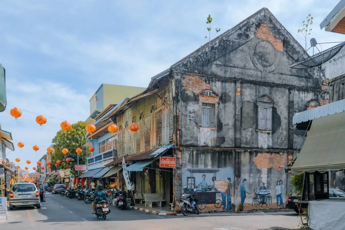
20 Best Places to Visit in Songkhla, Southern Thailand Songkhla is one of the most important provinces in Southern Thailand, distinguished by an exceptional combination of sea, lake, mountains, waterfalls, historic neighborhoods, communities, culture, and economic activity. The province includes historic Songkhla Town with its old architecture, Hat Yai as one of Southern Thailand’s major commercial and transport centers, Ko Yo with its traditional lake-based community, the Sathing Phra Peninsula with ancient temples and cultural heritage, and forested mountain areas close to the Thailand–Malaysia border.
For first-time visitors to Songkhla, the key places to begin with are Laem Samila, Ko Yo, Khao Tang Kuan, Kim Yong Market, Ton Nga Chang Waterfall, Songkhla Old Town, Tinsulanonda Bridge, the Institute for Southern Thai Studies, Wat Phra Ratchapraditthan or Wat Pha Kho, and Khao Nam Khang National Park. Together, these Top 10 attractions provide a broad introduction to Songkhla’s coastline, viewpoints, markets, local lifestyles, history, religion, culture, and natural landscapes.
Songkhla’s geography is particularly distinctive because the province lies between the Gulf of Thailand and the Songkhla Lake system. Central and northern areas include the Sathing Phra Peninsula, which separates the lake from the Gulf coastline, while the southern and western parts of the province contain mountains, humid evergreen forest, waterfalls, and areas approaching the Thailand–Malaysia border. This diversity makes it possible to walk along a beach in the morning and continue to an old town, local market, waterfall, or mountain forest later the same day.
Songkhla Lake is a vast lake and lagoon system that has long played an important role in the ecology, economy, and daily life of Southern Thai communities. Around the lake are fishing settlements, fish cages, agricultural areas, waterbird habitats, and transport routes. Ko Yo and Tinsulanonda Bridge are two of the best places for travelers to understand how local communities and the lake remain closely connected.
Songkhla’s history is deeply rooted in its role as a port and trading area on the Malay Peninsula. Archaeological evidence and old settlements around Sathing Phra reflect links with maritime trading networks from ancient times. In later periods, Songkhla Town absorbed influences from Thai, Chinese, Malay, and Western communities, creating a diverse urban landscape of religious sites, commercial streets, and architectural styles.
Songkhla Old Town around Nakhon Nok Road, Nakhon Nai Road, and Nang Ngam Road still preserves Chinese shophouses, Sino-European buildings, historic homes, shrines, long-established restaurants, and contemporary street art. The district is one of the most enjoyable historic neighborhoods to explore on foot in Southern Thailand and offers an excellent introduction to Songkhla’s development as a maritime trading town.
Songkhla’s culture reflects the long coexistence of Thai Buddhist, Thai Muslim, and Thai-Chinese communities. Important traditions are therefore highly diverse, ranging from Chak Phra and Tak Bat Devo Buddhist ceremonies and religious traditions of the Sathing Phra Peninsula to Hari Raya celebrations in Muslim communities and Vegetarian Festival rituals among Chinese communities in Hat Yai.
One tradition that strongly reflects the identity of the Songkhla Lake basin is the Chak Phra Festival, held after the end of Buddhist Lent. Communities decorate ceremonial Buddha-image vehicles and take part in processions by land and, in some areas, by water. The tradition brings together religion, community participation, traditional craftsmanship, and ways of life around the lake and remains one of the most recognizable cultural traditions of Southern Thailand.
The Sathing Phra area is also home to historic temples and communities associated with the legends of Luang Pu Thuat and with the long development of Buddhism on the peninsula. Hat Yai, meanwhile, reflects a different side of Songkhla through its Chinese-influenced commercial culture and cross-border links with Malaysia. The province therefore combines old-town life, lake communities, border culture, and a modern trading city within a single destination.
Songkhla’s local food is equally diverse. Dishes worth trying include khao yam, budu sauce, Southern Thai curries, fresh seafood, Songkhla-style beef or meat stew, khanom chin, roti, biryani-style rice, dim sum, and Chinese-style dishes associated with Hat Yai. Ko Yo is especially well known for cage-raised white seabass, lake seafood, and local fruit such as champedak.
Hat Yai is one of Southern Thailand’s major food cities. Travelers can begin the morning with dim sum and tea, enjoy Chinese or Southern Thai dishes for lunch, shop at Kim Yong Market or Santisuk Market during the day, and explore night markets in the evening. Songkhla Town, meanwhile, has long-established restaurants, local stew dishes, and traditional foods concentrated around Nakhon Nai, Nakhon Nok, and Nang Ngam roads.
This guide selects 20 attractions across different areas and travel styles. The Top 10 focus on the landmarks that first-time visitors should know, while attractions 11–20 expand the journey into museums, temples, a mosque, an aquarium, markets, waterbird habitats, beaches, waterfalls, and historical sites across the province, providing a broader view of Songkhla beyond Songkhla Town and Hat Yai.
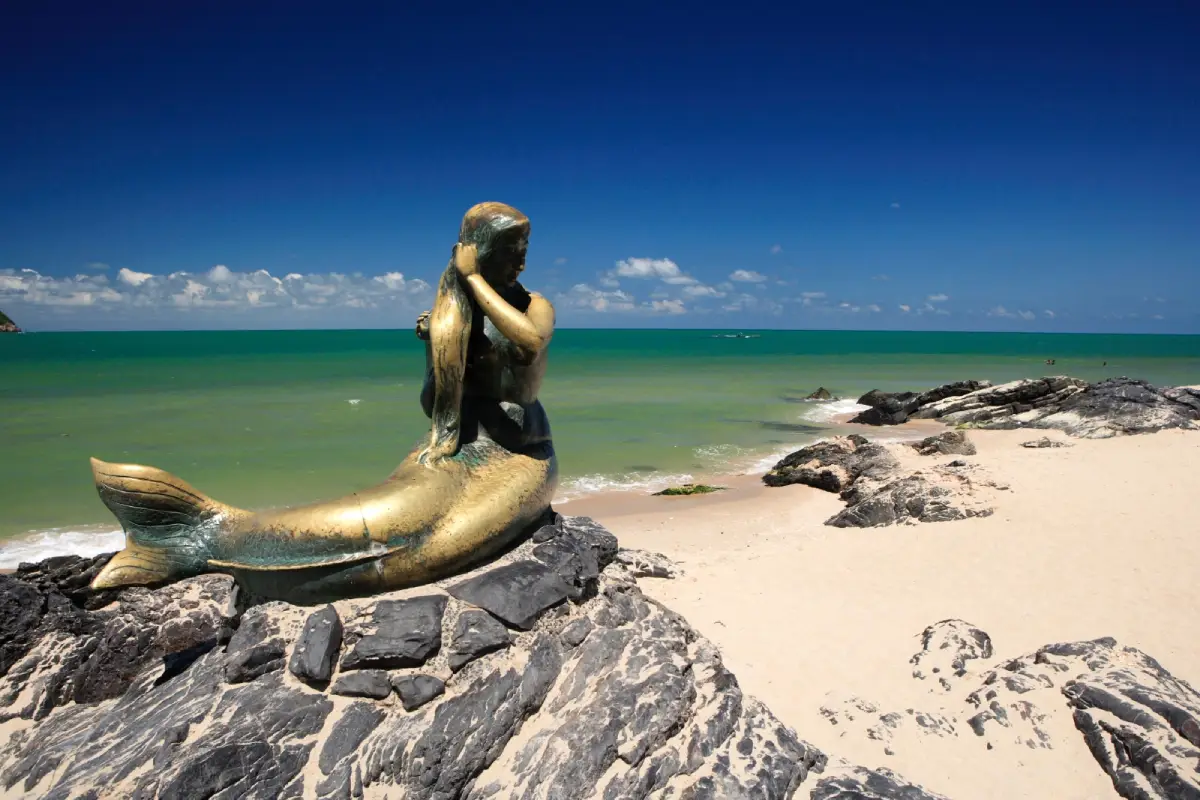
1. Laem Samila is one of the most important seaside landmarks in Songkhla Town. Located in Bo Yang Subdistrict, Mueang Songkhla District, it is known for its beach, casuarina trees, seaside recreation areas, the Golden Mermaid statue, the rat-and-cat sculptures, and views of Ko Nu and Ko Maeo offshore.
The Golden Mermaid statue is one of the best-known symbols of Songkhla. Standing on a seaside rock, the sculpture is linked with a local folktale about a mermaid who came ashore to comb her hair. The image of the mermaid against the Gulf of Thailand has become one of the province’s most recognizable travel icons.
The beach area is suitable for walking, relaxing, photography, and enjoying the atmosphere of a coastal city. Mornings are usually quieter and more comfortable, while evenings become livelier. Visitors can easily combine Laem Samila with Khao Tang Kuan, Laem Son On, Suan Seri, and Songkhla Old Town in the same day.
Although the beach is a public area that can be visited throughout the day, swimming conditions should always be judged according to actual waves, wind, and sea conditions, especially when the Gulf of Thailand is affected by monsoon weather. Swimming should be avoided during rough seas or whenever official warnings are in place.
Getting There: From Songkhla Old Town or central Songkhla Municipality, travel toward Bo Yang Subdistrict and follow the road to Laem Samila. The distance is short and the area can be reached by car, motorcycle, local transport, or as a continuation from Khao Tang Kuan.
Map (GPS): https://maps.app.goo.gl/KkR9XVeMzpcWNFnW7
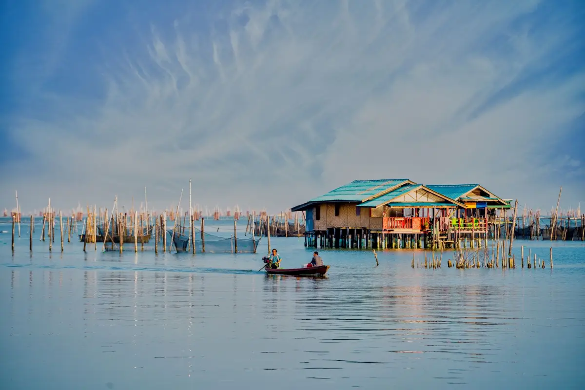
2. Ko Yo is a community island in the lower part of Songkhla Lake in Mueang Songkhla District, connected to the mainland by Tinsulanonda Bridge. Its main attractions include traditional fishing, white-seabass cages, orchards, Ko Yo woven cloth, historic temples, local restaurants, and the Institute for Southern Thai Studies.
The island’s landscape includes flat areas, foothills, and low hills, allowing local residents to combine fishing with agriculture. Particularly important is the traditional suan somrom, or mixed orchard, where several types of fruit are grown together, including pomelo, jackfruit, champedak, and coconut. This farming system reflects local knowledge adapted to the island environment.
Ko Yo woven cloth is another well-known form of local craftsmanship. Its patterns and weaving techniques have been passed down within the community for generations. Visitors can shop for locally made textiles or learn about weaving traditions while combining the trip with the Institute for Southern Thai Studies and temples around the island.
Food is another major reason to visit Ko Yo, especially cage-raised white seabass and seafood from Songkhla Lake. Many restaurants sit close to the shoreline, allowing travelers to enjoy local dishes while looking across the lake and toward Tinsulanonda Bridge.
Getting There: From Songkhla city, take Highway 407, connect with Highway 4083, and cross Tinsulanonda Bridge onto Ko Yo. Once on the island, visitors can drive around the local road network, making a private car or motorcycle the most convenient option.
Map (GPS): https://maps.app.goo.gl/Gd6u9GuSURSutgpM7
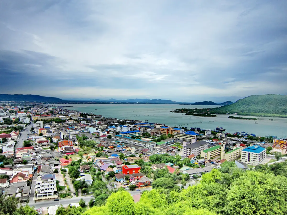
3. Khao Tang Kuan is located in Bo Yang Subdistrict, Mueang Songkhla District. Rising approximately 105 meters above sea level, this hill in the center of the city is one of Songkhla’s most important viewpoints, offering panoramic views of Songkhla Town, Songkhla Lake, the Gulf of Thailand, Samila Beach, Laem Son On, and the old-town district.
At the summit stands Phra Chedi Luang, an important sacred monument associated with Songkhla, together with historical structures such as Sala Phra Wihan Daeng, a lighthouse, and panoramic viewpoints. A visit to Khao Tang Kuan therefore combines religion, history, architecture, and landscape in a single destination.
Visitors can reach the summit using the available visitor transport system or walk up the naga staircase where access is permitted. Walking is suitable for travelers who want some exercise and a closer experience of the hill, although physical condition and weather should be considered before choosing this option.
Khao Tang Kuan combines easily with Laem Samila, Khao Noi, Suan Seri, and Songkhla Old Town. For a half-day route, travelers can begin in the old town, visit the hill during the afternoon, and then continue down to the seaside at Samila in the evening.
Getting There: Khao Tang Kuan is located within Songkhla Municipality in Bo Yang Subdistrict, close to Laem Samila and Khao Noi. Visitors can reach the base by car, motorcycle, or local transport and then continue to the summit using the access system available on the day.
Map (GPS): https://maps.app.goo.gl/jp8sb8JfGJ5EPTYH6
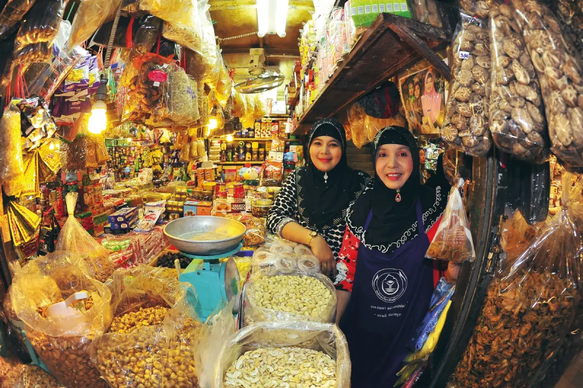
4. Kim Yong Market is one of the most important markets in central Hat Yai and one of the best-known places in Southern Thailand for buying local products and souvenirs. It occupies a commercial area around Supasarnrangsan Road, Nipat Uthit Road, and Saeng Arthit Road, close to Hat Yai Railway Station and the central business district.
The market sells a wide range of products, including dried foods, snacks, drinks, fruit, fresh ingredients, imported products, and souvenirs from Thailand and neighboring countries. This variety reflects Hat Yai’s long-standing role as a trading city and major transport hub for Southern Thailand.
Morning is the best time for visitors who want to experience the fresh-market atmosphere and local trading activity, while late morning and afternoon are convenient for souvenir shopping. Travelers should compare prices and check expiry dates on packaged goods, especially imported products.
Kim Yong Market can easily be explored together with Santisuk Market, Hat Yai Railway Station, and other parts of the city center. In the evening, visitors can continue to Greenway Market or one of Hat Yai’s night-market areas for a different shopping atmosphere.
Getting There: The market is in central Hat Yai, close to the railway station and major hotel areas. It can be reached on foot from the city center, by tuk-tuk, local transport, or private car. During busy periods, parking outside the immediate market area and walking in is often more practical.
Map (GPS): https://maps.app.goo.gl/ATX8GmcBcHP14mYi7
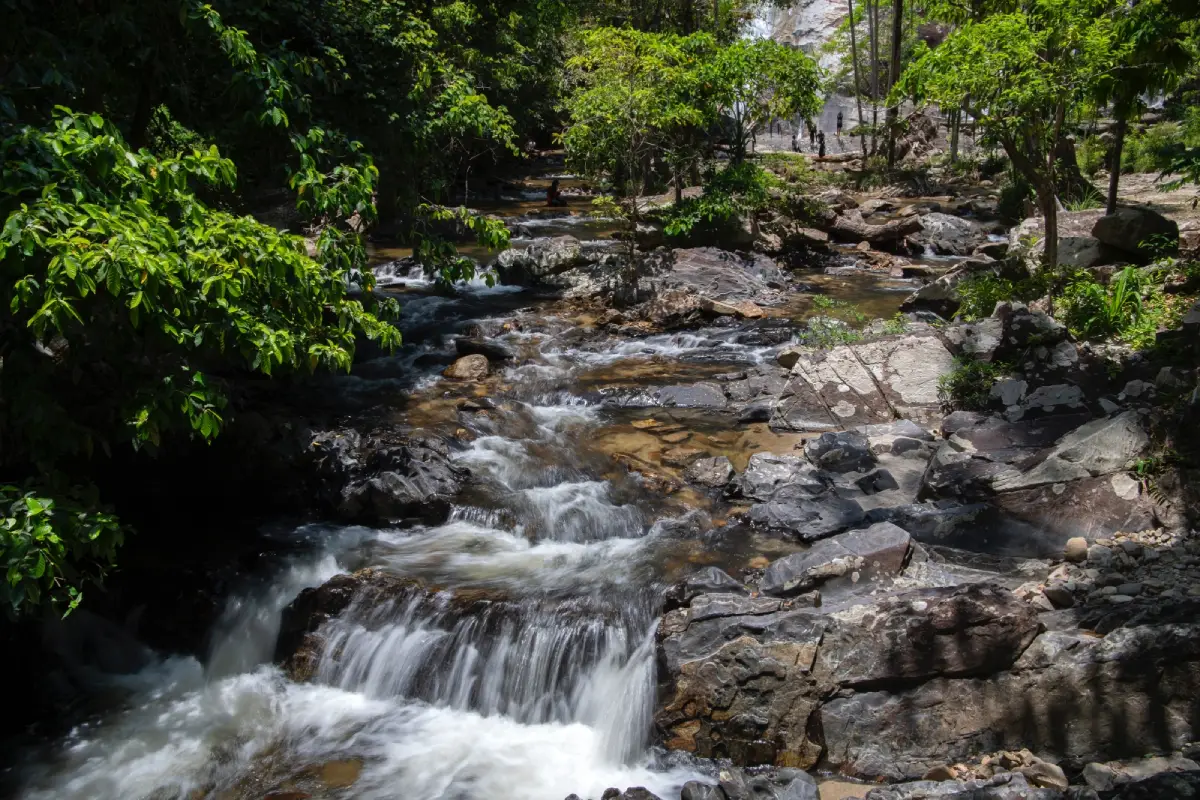
5. Ton Nga Chang Waterfall is located inside Ton Nga Chang Wildlife Sanctuary in Thung Tam Sao Subdistrict, Hat Yai District. It is one of Songkhla’s most important waterfalls and a popular natural destination for travelers who want to leave the busy atmosphere of Hat Yai and experience humid evergreen forest.
The waterfall has 7 tiers, each with a different character. The best-known is the third tier, Ton Nga Chang, where the waterfall divides into 2 streams before dropping into the pool below, creating a shape resembling elephant tusks. This formation gave the waterfall its name and is one of Songkhla’s most recognizable natural sights.
The walk becomes more demanding at the higher tiers, with rocky, wet, slippery, and sometimes steep terrain. Visitors should choose how far to climb according to their physical condition, avoid higher sections during heavy rain, and remain alert to flash floods or rapidly changing currents.
When water levels are suitable, the forest becomes lush and the waterfall particularly attractive, but weather conditions should always be checked before departure. Families can enjoy the lower areas and visitor zones without needing to climb to every tier.
Getting There: From central Hat Yai, travel toward Thung Tam Sao Subdistrict and follow the route to Ton Nga Chang Wildlife Sanctuary. A private or rental car is the most convenient option, and visitors should allow enough time to return before late evening.
Map (GPS): https://maps.app.goo.gl/E8K4kK6QcLD1fhEx9
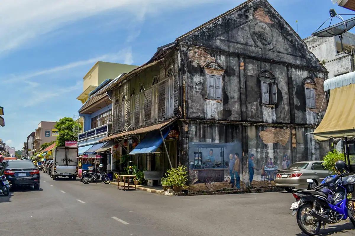
6. Songkhla Old Town is an important historic district in Mueang Songkhla, centered on Nakhon Nok Road, Nakhon Nai Road, and Nang Ngam Road. The neighborhood brings together historic buildings, Chinese shophouses, shrines, restaurants, old houses, and street art within an area that is easy to explore on foot.
The architecture reflects Songkhla’s history of trade between Thai and Chinese communities and merchants who passed through the old port. Some buildings retain traditional Chinese forms, while others show Western and Sino-European influence. Many historic shophouses are still actively used as homes, restaurants, cafés, and businesses.
Nang Ngam Road is particularly well known for traditional food and long-established shops, while Nakhon Nai and Nakhon Nok roads are ideal for observing old houses, street art, and the atmosphere of the historic community. Walking slowly allows visitors to notice architectural details such as doors, windows, signs, and decorative elements that are easily missed when driving through.
Songkhla Old Town connects easily with the Prem Tinsulanonda Historical Museum, Wat Matchimawat, Songkhla City Pillar Shrine, Khao Tang Kuan, and Laem Samila. It is therefore possible to plan an entire day around central Songkhla without long-distance driving.
Getting There: Songkhla Old Town is located within Songkhla Municipality. Visitors can arrive by private car or local transport, park around the edge of the historic district, and continue on foot along Nakhon Nok, Nakhon Nai, and Nang Ngam roads.
Map (GPS): https://maps.app.goo.gl/szdZ4496gQCQ9veb9
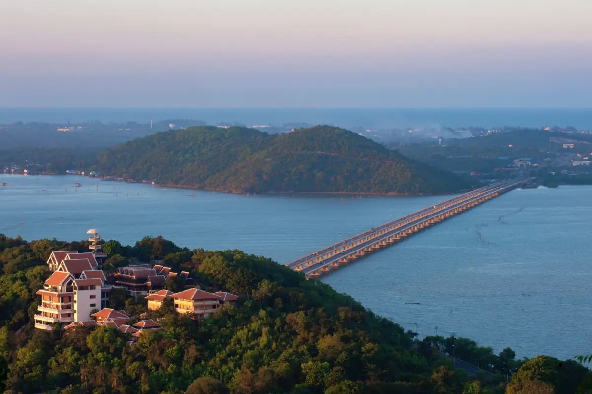
7. Tinsulanonda Bridge is an important transport landmark crossing Songkhla Lake and connecting the Songkhla mainland, Ko Yo, and Singhanakhon District. It greatly improved movement around the lake and has become one of the clearest visual symbols of Songkhla’s lake landscape.
While driving across the bridge, travelers can see Songkhla Lake, Ko Yo, fish cages, fishing boats, and shoreline communities. The view helps illustrate the importance of the lake to settlement patterns, fisheries, transport, and the local economy.
The bridge remains an active public road, so visitors should never stop or park for photographs in prohibited areas. Safer viewpoints and stopping areas can be found on Ko Yo and near the bridge approaches.
The bridge is best combined with Ko Yo, the Institute for Southern Thai Studies, Wat Laem Pho, and attractions in Singhanakhon. Morning and late afternoon provide particularly attractive light over the lake and surrounding fish cages.
Getting There: Tinsulanonda Bridge forms part of the road network connecting Highway 407 with Ko Yo and the Singhanakhon route. From Songkhla city, simply follow the road signs toward Ko Yo and the bridge.
Map (GPS): https://maps.app.goo.gl/ikhf5ARBgdQKHGxN9
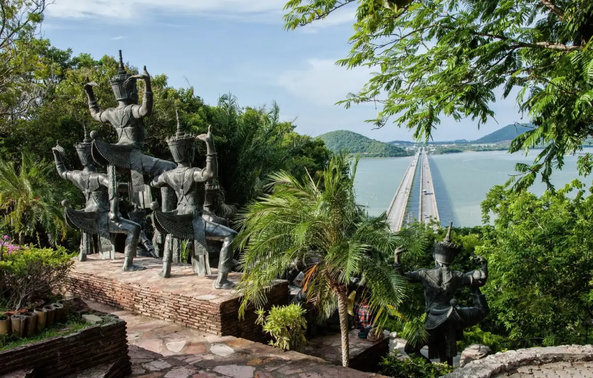
8. Institute for Southern Thai Studies is located at Ban Ao Sai in Ko Yo Subdistrict, Mueang Songkhla District. It is one of Southern Thailand’s most important centers for learning about regional culture, traditional knowledge, history, and local ways of life. Its elevated location on Ko Yo also provides wide views over Songkhla Lake and Tinsulanonda Bridge.
The institute was established to collect, study, preserve, and disseminate knowledge about Southern Thailand. Its exhibitions cover local livelihoods, religion, beliefs, handicrafts, traditional tools, folk culture, and the artistic traditions of communities across the southern provinces.
The buildings are inspired by Southern Thai vernacular architecture, including hipped-roof and gabled-house forms designed for the region’s hot and humid climate. As a result, the architecture itself forms part of the cultural learning experience rather than simply serving as a container for exhibitions.
Its hillside location makes the institute both a museum complex and a viewpoint. Visitors can explore Southern Thai cultural exhibitions before continuing to local seafood restaurants, Ko Yo weaving communities, temples, and other attractions around the island.
Getting There: From Songkhla city, cross Tinsulanonda Bridge onto Ko Yo and follow the road toward Ban Ao Sai and the Institute for Southern Thai Studies. A private or rental car is the most convenient option because the complex is located on elevated terrain.
Map (GPS): https://maps.app.goo.gl/WEYV7EN9bxSskntr8
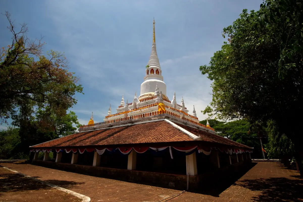
9. Wat Phra Ratchapraditthan (Wat Pha Kho) is located on Khao Phattha Sing in Chumphon Subdistrict, Sathing Phra District. It is one of the oldest and most important Buddhist sites on the Sathing Phra Peninsula and is closely associated with Somdet Chao Pha Kho, widely known as Luang Pu Thuat of the famous sea-water-to-fresh-water legend.
Important sites within the temple include Phra Suwan Malika Chedi Si Rattana Mahathat, the reclining Buddha, a sacred Buddha footprint, hilltop religious structures, statues of Luang Pu Thuat, a museum, and several historic remains. Visitors can therefore combine worship with learning about the long development of Buddhism around the Songkhla Lake basin.
The Sathing Phra Peninsula is an ancient cultural landscape with deep religious and historical importance. Wat Pha Kho is therefore more than a pilgrimage site: it is also evidence of a long network of temples, communities, and routes linking the Gulf of Thailand with Songkhla Lake.
Visitors should dress modestly, remain respectful, and keep noise low within sacred areas. Wat Pha Kho can be combined with Sathing Phra Beach, Khu Khut Waterfowl Park, and other historic temples and communities on the peninsula.
Getting There: From Songkhla city, cross Tinsulanonda Bridge toward Singhanakhon and continue along the Sathing Phra route to Chumphon Subdistrict. The temple is located on Khao Phattha Sing, approximately 48 kilometers from Songkhla city.
Map (GPS): https://maps.app.goo.gl/7zQCsvq6iEgCj6q9A
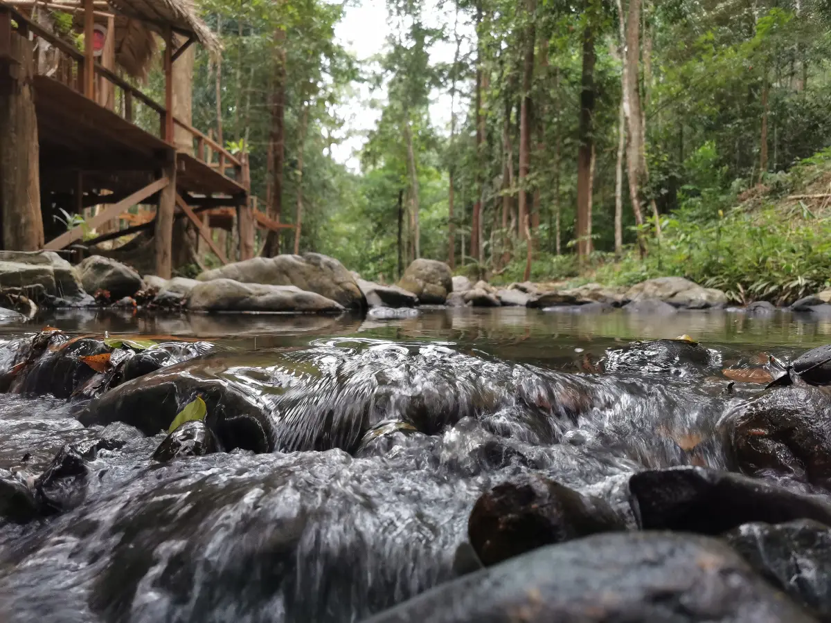
10. Khao Nam Khang National Park is a forested mountain area in southern Songkhla covering parts of Na Thawi and Sadao districts near the Thailand–Malaysia border. Its main attractions are humid evergreen forest, streams, waterfalls, rugged mountain terrain, and modern political history associated with the border region.
Khao Nam Khang is an important watershed area with a cool, humid mountain environment very different from Songkhla’s coastal landscape. Visitors can explore forest scenery, waterfalls, and nature trails in areas that are officially open to the public.
Another major dimension of the park is the history of communist insurgents who once used the mountainous and densely forested terrain as an operational base. Important physical evidence remains at the Khao Nam Khang Historical Tunnel, also known as Piyamit 5 Village, which has been developed into a historical learning attraction.
Visitors should check national park announcements, weather, and road conditions before traveling, particularly during the rainy season when heavy rain, slippery roads, and flash floods may affect some areas. Appropriate footwear and outdoor equipment are recommended for nature trails.
Getting There: From Hat Yai, travel toward Na Thawi District and Khlong Kwang Subdistrict, following the route to Khao Nam Khang National Park. Visitors continuing to the historical tunnel should use a private or rental car and allow sufficient time for mountain roads.
Map (GPS): https://maps.app.goo.gl/DQAMD78huaV4nbVx5
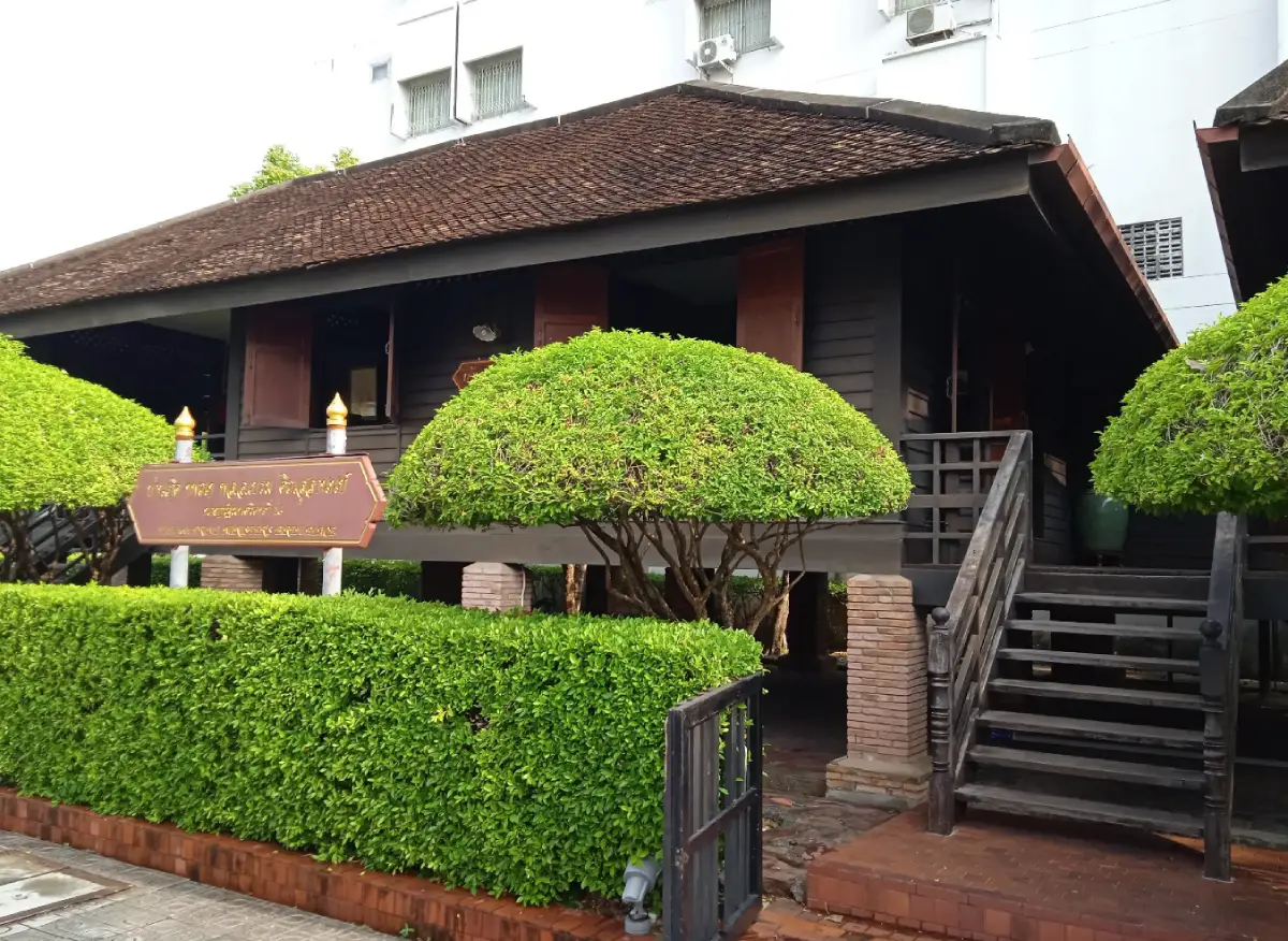
11. Phathammarong Museum is located at 1 Chana Road, Bo Yang Subdistrict, Mueang Songkhla District, close to Songkhla National Museum and Songkhla Old Town. Although relatively compact, the museum holds considerable significance for both local history and modern Thai political history because it recreates the atmosphere of the former Tinsulanonda family residence.
The site was once associated with the residence of Khun Winit Thanthakam, also known as Bueng Tinsulanonda, the father of General Prem Tinsulanonda, a Songkhla native who later served as Prime Minister of Thailand and became a prominent statesman. The present museum was constructed in traditional Thai architectural style to recreate the atmosphere of the family home and the early environment in which General Prem grew up.
The word “Phathammarong” refers to a former official position within Thailand’s correctional administration. The title was associated with prison supervision and appeared in the Thai administrative system for many years. Using this historical term as the museum’s name directly reflects the government service of Khun Winit Thanthakam.
Inside, visitors can learn about family life, the atmosphere of a government officer’s residence, and the relationship between a nationally important public figure and his hometown of Songkhla. The museum is particularly suitable for travelers interested in modern Thai history who want to explore Songkhla Old Town with greater historical context.
Getting There: The museum is located on Chana Road within Songkhla Municipality, close to Songkhla National Museum, Nang Ngam Road, and the old-town district. It can be reached by private car, motorcycle, local transport, or on foot from nearby attractions.
Map (GPS): https://maps.app.goo.gl/fVFiqkSthVytW6LE9
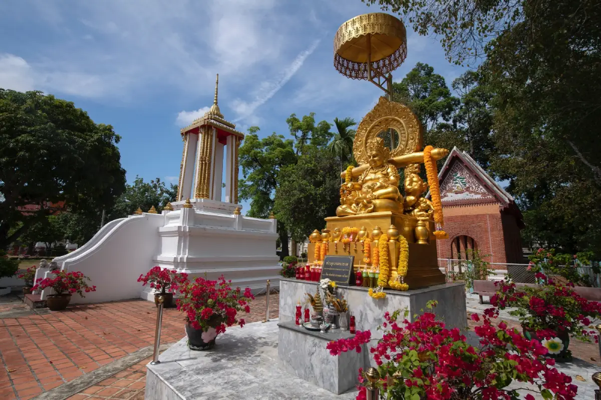
12. Wat Matchimawat Worawihan (Wat Klang) is located on Saiburi Road in Bo Yang Subdistrict, Mueang Songkhla District. It is an old royal temple and one of the most important Buddhist temples in Songkhla, with a history extending back several centuries and strong connections with Buddhism, Chinese communities, maritime trade, and the development of the old port town.
According to local tradition, the temple was originally known as “Wat Yai Si Chan.” Local residents later began calling it “Wat Klang,” meaning the temple in the middle, because it stood between other important temples in the surrounding community. The formal name Matchimawat carries essentially the same meaning of being centrally located.
Highlights include the ordination hall with Thai-Chinese artistic influences, historic mural paintings, a marble principal Buddha image, gateways incorporating several architectural traditions, and the Matchimawat National Museum, which preserves antiquities collected from Songkhla, Sathing Phra, Ranot, and surrounding areas.
The temple fits naturally into a Songkhla Old Town itinerary. Visitors can continue easily to the Songkhla City Pillar Shrine, Nang Ngam Road, Nakhon Nai Road, Phathammarong Museum, and Laem Samila. Appropriate clothing and respectful behavior are expected within the temple grounds.
Getting There: Wat Matchimawat is located on Saiburi Road in central Songkhla. It is within short distance of the old-town area, making it practical to park nearby and explore several heritage attractions on foot.
Map (GPS): https://maps.app.goo.gl/rNV6Byrku6yBZPQg6

13. Songkhla Aquatic Animal Exhibition Center (Songkhla Aquarium) is located at the tip of Laem Son On in Bo Yang Subdistrict, Mueang Songkhla District. It was developed as a learning center for aquatic animals and Southern Thailand’s water ecosystems, linking freshwater, brackish-water environments, Songkhla Lake, mangrove forests, and the Gulf of Thailand.
The core concept of the aquarium is to help visitors understand aquatic biology, animal behavior, ecosystem relationships, and marine-resource conservation. It is especially suitable for families, students, and travelers who want to understand Songkhla’s natural environment before exploring the province’s real coastal and wetland ecosystems.
The original exhibition concept included freshwater, brackish-water, and marine zones as well as display tanks and an underwater viewing tunnel. However, the aquarium is currently undergoing restoration, and visitor access depends on the latest on-site announcements. Travelers should therefore confirm its operating status before making a special trip.
Its location at Laem Son On makes it easy to combine with Laem Samila, Song Thale Park, Ko Nu–Ko Maeo, and Khao Tang Kuan, making the area suitable for a family-oriented day in Songkhla city.
Getting There: From Laem Samila, continue toward the tip of Laem Son On. The aquarium is located along the coast in Bo Yang Subdistrict. Visitors should confirm current access before traveling to avoid arriving while the facility is closed for restoration.
Map (GPS): https://maps.app.goo.gl/ob4Qf9A3pq4JouiG6
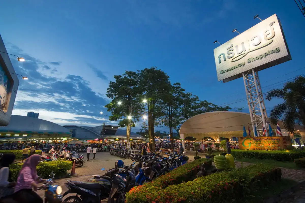
14. Greenway Night Market is located near Khlong Rian Intersection on Kanchanavanich Road in Hat Yai District. It is one of Hat Yai’s most popular evening markets, attracting local residents, students, and travelers with a wide selection of food, clothing, lifestyle goods, souvenirs, and contemporary market stalls.
Greenway has a very different atmosphere from Kim Yong Market. Kim Yong is strongest during the daytime and is known for souvenirs, dried foods, imported snacks, and traditional downtown commerce, while Greenway focuses on evening dining, fashion, second-hand goods, and casual walking after sunset.
The food zone is one of its main attractions, offering Southern Thai dishes, Thai food, Chinese dishes, desserts, drinks, and modern street food. This makes Greenway an easy place to end a day after visiting attractions around Hat Yai.
The market is close to major city routes and can be combined with Prince of Songkla University, Kho Hong, and other attractions around eastern Hat Yai. Visitors should allow extra time for traffic in the evening, particularly on weekends and holidays.
Getting There: Greenway Night Market is located on Kanchanavanich Road near Khlong Rian Intersection. It is easily reached from central Hat Yai by car, motorcycle, tuk-tuk, local taxi, or other hired transport.
Map (GPS): https://maps.app.goo.gl/cWxtmPxHLHSS8HMS9
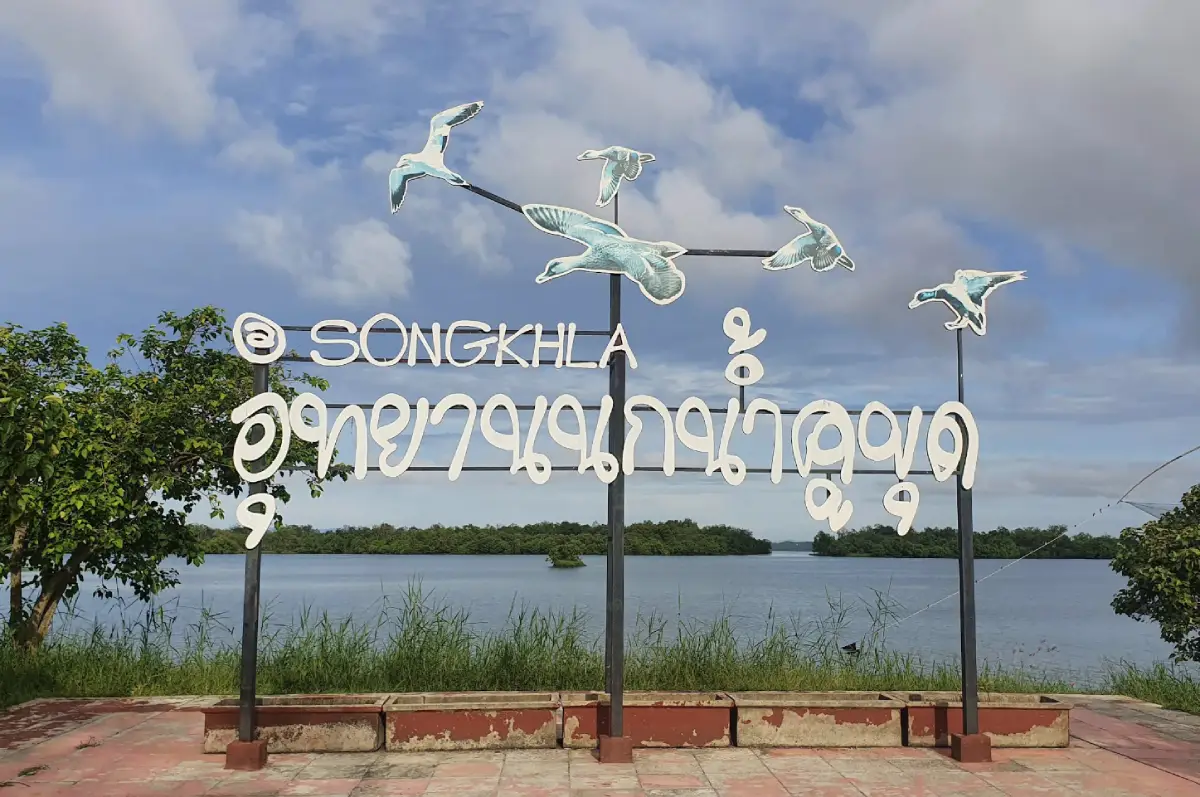
15. Khu Khut Waterfowl Park (Thale Sap Songkhla Non-Hunting Area) is located at Moo 4, Khu Khut Subdistrict, Sathing Phra District. It is one of the most important protected wetland and waterbird habitats in the Songkhla Lake system and is particularly suitable for birdwatching, photography, nature study, and understanding the relationship between wetlands and local communities.
The Songkhla Lake Non-Hunting Area has long been protected as wildlife habitat and supports both resident and migratory waterbirds. Its landscape includes open water, shallow wetland zones, small islands, aquatic vegetation, and feeding areas used by large numbers of birds.
Early morning and late afternoon are generally the best times for birdwatching because temperatures are lower and bird activity is often greater. Visitors should remain quiet, avoid approaching flocks too closely, and never disturb nesting areas.
Khu Khut Waterfowl Park can be combined with Wat Pha Kho, Sathing Phra Beach, and communities on the Sathing Phra Peninsula, creating a full-day route from Songkhla that combines religion, nature, wetlands, and lake-based ways of life.
Getting There: From Songkhla city, cross Tinsulanonda Bridge and travel north toward Sathing Phra District. Continue to Khu Khut Subdistrict and follow signs to the Songkhla Lake Non-Hunting Area. A private car is the most convenient option for this route.
Map (GPS): https://maps.app.goo.gl/CWohYoEten6g8pZd6
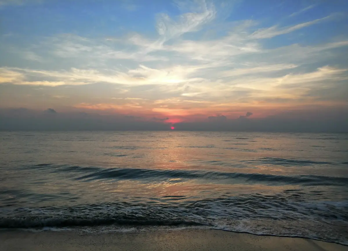
16. Sathing Phra Beach (Hat Maharat) is an important beach in Sathing Phra District on the Gulf of Thailand and forms part of the long coastline of the Sathing Phra Peninsula. The atmosphere is generally quieter than Samila Beach and is well suited to travelers who prefer a more local and peaceful seaside setting.
The beach stretches along the Gulf coast and offers space for walking, sea views, and experiencing the coastal character of Sathing Phra communities, whose lives are influenced by both the Gulf of Thailand on one side of the peninsula and Songkhla Lake on the other.
Morning is especially suitable for beach walks and sunrise views, while late afternoon works well as a relaxing stop after visiting Wat Pha Kho or Khu Khut Waterfowl Park. Swimming should always depend on actual wave, wind, and shoreline conditions on the day of travel.
A visit to Sathing Phra Beach reveals a quieter side of Songkhla than the city’s better-known beaches. Its setting remains closely linked with fishing communities, agriculture, and everyday life on the peninsula rather than a large urban seaside tourism district.
Getting There: From Songkhla city, cross Tinsulanonda Bridge and follow the Sathing Phra road north to the district center. Continue toward the Gulf coast following signs for Sathing Phra Beach or Hat Maharat.
Map (GPS): https://maps.app.goo.gl/xwq3Xb5AZSQfyZ8P6
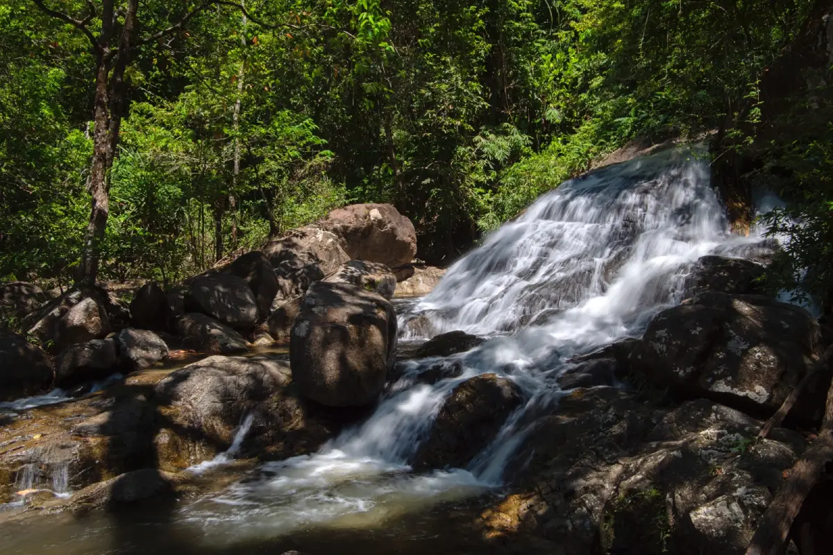
17. Namtok Boriphat Forest Park is located around Ban Khao Soi Dao, Moo 10, Khao Phra Subdistrict, Rattaphum District. This natural attraction on the western side of Songkhla helps extend travel beyond Songkhla city and Hat Yai, with humid evergreen forest, streams, and a waterfall in a shaded mountain environment.
The area around the waterfall is surrounded by trees and natural forest and is suitable for relaxation, short forest walks, and enjoying the stream. Travelers looking for a quieter nature trip without demanding outdoor activity can comfortably spend half a day here.
Water volume varies according to the season. After sufficient rain, the waterfall is more visible and the forest becomes especially green, but heavy rainfall can also create slippery surfaces, stronger currents, and flash-flood risks. Swimming should be avoided whenever conditions appear unsafe.
Namtok Boriphat Forest Park is particularly useful for travelers passing through Rattaphum District or continuing toward Phatthalung. It adds an inland forest-and-waterfall experience to a Songkhla itinerary without requiring a return to Hat Yai.
Getting There: From Hat Yai or Songkhla city, travel toward Rattaphum District, then continue into Khao Phra Subdistrict and Ban Khao Soi Dao, Moo 10. A private or rental car is the most convenient option.
Map (GPS): https://maps.app.goo.gl/RJFi8QoSySvezwjk7
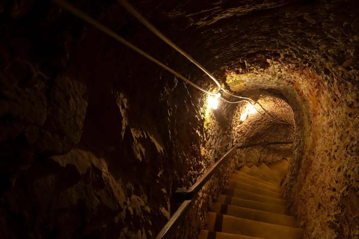
18. Khao Nam Khang Historical Tunnel is located at Moo 1, Khlong Kwang Subdistrict, Na Thawi District, within Khao Nam Khang National Park. It is also known as Piyamit 5 Village and represents an important physical record of political conflict and border history in Southern Thailand during the 20th century.
Construction of the tunnel began in 1972 and was carried out manually inside the mountain, taking approximately 2 years to complete. The underground network extends for about 1,000 meters in a winding system with several levels and multiple entrances and exits and was designed to accommodate a significant number of people during its operational period.
One of the most interesting aspects is the highly organized use of underground space. The tunnel system included meeting rooms, radio facilities, a medical room, kitchen, living areas, and other operational spaces, illustrating how people adapted to living and working beneath the mountain during a period of political conflict.
Today, the site has been preserved and developed as a historical learning attraction. Travelers can study this chapter of regional history while also exploring Khao Nam Khang National Park, with its forest, waterfalls, and border mountain landscape.
Getting There: From Na Thawi District, travel toward Khlong Kwang Subdistrict and Khao Nam Khang National Park. The tunnel is approximately 4 kilometers from the national park office. A private or rental car is recommended, and road conditions should be checked during the rainy season.
Map (GPS): https://maps.app.goo.gl/6bFoJcMmpp4xc2Ks5
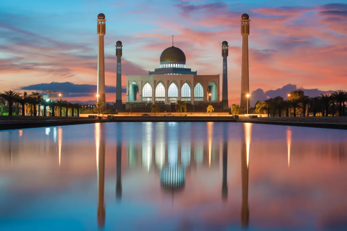
19. Songkhla Central Mosque, also known as Masjid Klang Diy-Nul Islam, is located on Lopburi Ramesuan Road in Khlong Hae Subdistrict, Hat Yai District. It is the provincial center of Islamic religious life and one of the most visually distinctive architectural landmarks in modern Songkhla.
The large white mosque features a golden dome, tall minarets, Islamic arches, and a broad reflecting pool in front of the building. The reflection of the mosque across the long pool has led to its popular nickname, the “Taj Mahal of Thailand,” and has made the site a well-known photography destination.
Its importance, however, extends far beyond architecture. The mosque remains an active place of worship, a spiritual center for Muslim communities, and a venue for provincial Islamic activities. Visitors should therefore approach it primarily as a living religious site rather than simply as a sightseeing location.
Visitors should dress modestly, avoid entering active prayer areas during prayer times, and ask permission before photographing worshippers or certain interior spaces. Late afternoon often provides beautiful light around the reflecting pool, but religious activities must always take priority over photography.
Getting There: The mosque is located on Lopburi Ramesuan Road between central Hat Yai and the main route toward Songkhla city. It can be reached conveniently by private car, rental car, tuk-tuk, or other hired transport.
Map (GPS): https://maps.app.goo.gl/WzMbrGPBzpDXZRgL9
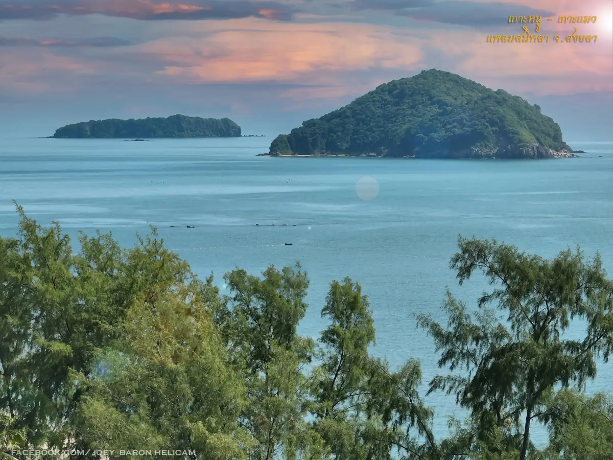
20. Ko Nu–Ko Maeo (Mouse Island and Cat Island) are a pair of offshore islets visible clearly from Laem Samila and Laem Son On. They are among Songkhla’s most recognizable natural symbols and are closely connected with one of the province’s best-known local folktales.
The island closer to shore is known as Ko Nu, or Mouse Island, while the island farther out is Ko Maeo, or Cat Island. Their silhouettes against the Gulf of Thailand form one of Songkhla’s classic coastal views, together with the Golden Mermaid statue and Samila Beach.
The local legend of Ko Nu–Ko Maeo tells of animals connected with a Chinese merchant and a magical crystal, followed by events that eventually transformed the mouse and cat into the two islands. The story is also represented by the mouse-and-cat sculptures near Laem Samila and has become part of Songkhla’s tourism identity.
Most travelers simply view the islands from the coast, which is easy and suitable for visitors of all ages. Boat trips that approach or land on the islands depend on season, sea conditions, and local operators. Anyone choosing a boat trip should use an operator with appropriate safety equipment.
Getting There: The main viewpoints are Laem Samila, Samila Beach, and Laem Son On, where the islands can be seen without taking a boat. Travelers who want a marine trip should check local operators, weather, and wave conditions before departure.
Map (GPS): https://maps.app.goo.gl/9TC6vUsyb4NsaQ9q9
| Topic | Details |
| Province | Songkhla is one of Southern Thailand’s major provinces, combining the Gulf of Thailand, Songkhla Lake, historic neighborhoods, Hat Yai, islands, beaches, mountains, waterfalls, wetlands, the Sathing Phra Peninsula, and areas close to the Thailand–Malaysia border. |
| Travel Highlights | Laem Samila, Songkhla Old Town, Ko Yo, Songkhla Lake, Hat Yai, local markets, Ton Nga Chang Waterfall, the Sathing Phra Peninsula, Khao Nam Khang National Park, and the province’s Thai Buddhist, Thai Muslim, and Thai-Chinese cultures. |
| Top 10 Attractions | 1. Laem Samila 2. Ko Yo 3. Khao Tang Kuan 4. Kim Yong Market 5. Ton Nga Chang Waterfall 6. Songkhla Old Town 7. Tinsulanonda Bridge 8. Institute for Southern Thai Studies 9. Wat Phra Ratchapraditthan (Wat Pha Kho) 10. Khao Nam Khang National Park |
| Sea and Coast | Laem Samila, Sathing Phra Beach, and Ko Nu–Ko Maeo are among the main Gulf of Thailand attractions, while Laem Son On and other coastal areas around Songkhla city can easily be added to the same route. |
| Songkhla Lake | Ko Yo, Tinsulanonda Bridge, the Institute for Southern Thai Studies, and Khu Khut Waterfowl Park reveal the lake’s fishing culture, wetlands, local traditions, and long-standing relationship with surrounding communities. |
| Old Town and History | Songkhla Old Town, Phathammarong Museum, Wat Matchimawat, and the Nakhon Nai, Nakhon Nok, and Nang Ngam road areas reflect the development of the port town, trade, and Songkhla’s cultural diversity. |
| Nature and Waterfalls | Ton Nga Chang Waterfall, Namtok Boriphat Forest Park, and Khao Nam Khang National Park are key routes for travelers interested in evergreen forest, waterfalls, streams, and mountain scenery. |
| Religious Sites | Wat Phra Ratchapraditthan or Wat Pha Kho, Wat Matchimawat Worawihan, and Songkhla Central Mosque highlight the importance of both Buddhism and Islam in the province. |
| Important Culture | Chak Phra and Tak Bat Devo traditions, Hari Raya, the Vegetarian Festival, Hat Yai’s Chinese culture, Ko Yo community life, and traditions of the Sathing Phra Peninsula are important parts of Songkhla’s cultural identity. |
| Local Food | Khao yam, budu sauce, Songkhla-style stew, khanom chin, roti, biryani-style rice, dim sum, Hat Yai-style Chinese food, fresh seafood, Ko Yo white seabass, and champedak are among the local foods worth trying. |
| Mueang Songkhla District | 1. Laem Samila 2. Ko Yo 3. Khao Tang Kuan 4. Songkhla Old Town 5. Tinsulanonda Bridge 6. Institute for Southern Thai Studies 7. Phathammarong Museum 8. Wat Matchimawat Worawihan 9. Songkhla Aquarium 10. Ko Nu and Ko Maeo |
| Hat Yai District | 1. Kim Yong Market 2. Ton Nga Chang Waterfall 3. Greenway Night Market 4. Songkhla Central Mosque This area is ideal for urban sightseeing, food, shopping, nature, and experiencing Songkhla’s multicultural character. |
| Sathing Phra District | 1. Wat Phra Ratchapraditthan (Wat Pha Kho) 2. Khu Khut Waterfowl Park 3. Sathing Phra Beach (Hat Maharat) The district is an important part of the Sathing Phra Peninsula, combining religion, history, wetlands, and the Gulf of Thailand coastline. |
| Rattaphum District | Namtok Boriphat Forest Park is a key natural attraction featuring evergreen forest, waterfalls, and a peaceful inland environment on the western side of the province. |
| Na Thawi–Sadao Area | 1. Khao Nam Khang National Park 2. Khao Nam Khang Historical Tunnel This route is particularly suitable for travelers interested in mountain forest, the Thailand–Malaysia border region, and modern political history. |
| Top Activities | Walking through the old town, relaxing on beaches, viewing the city from hilltops, visiting markets, trying local food, exploring Ko Yo communities, birdwatching, hiking, visiting waterfalls, worshipping at temples, visiting a mosque, exploring museums, and learning about border history. |
| Best For | Families, couples, groups of friends, food travelers, old-town enthusiasts, cultural travelers, nature lovers, history enthusiasts, photographers, and visitors who want several travel styles within one province. |
| Getting to Songkhla | Songkhla is easily reached by air through Hat Yai International Airport, by rail through Hat Yai Junction Railway Station, or by road through Southern Thailand’s highway network. International travelers can also enter from Malaysia through border checkpoints in Songkhla Province. |
| Getting Around the Province | Hat Yai has local taxis, tuk-tuks, and other transport options, but a private or rental car is significantly more convenient for Ko Yo, Sathing Phra, Rattaphum, Na Thawi, and Khao Nam Khang. |
| 1-Day Itinerary — Songkhla City | Morning: Songkhla Old Town – Wat Matchimawat – Phathammarong Museum Afternoon: Khao Tang Kuan Evening: Laem Samila – View Ko Nu and Ko Maeo |
| 1-Day Itinerary — Hat Yai | Morning: Kim Yong Market – Central Hat Yai Afternoon: Ton Nga Chang Waterfall or Songkhla Central Mosque Evening: Greenway Night Market |
| 2-Day Itinerary | Day 1: Songkhla Old Town – Khao Tang Kuan – Laem Samila Day 2: Ko Yo – Institute for Southern Thai Studies – Tinsulanonda Bridge – Kim Yong Market – Greenway Night Market |
| 3-Day Itinerary | Day 1: Songkhla city and Laem Samila Day 2: Ko Yo – Tinsulanonda Bridge – Hat Yai Day 3: Ton Nga Chang Waterfall, or the Sathing Phra route – Wat Pha Kho – Khu Khut Waterfowl Park – Sathing Phra Beach |
| 4–5 Day Itinerary | Add Namtok Boriphat Forest Park, Khao Nam Khang National Park, Khao Nam Khang Historical Tunnel, Songkhla Central Mosque, and communities around Songkhla Lake for a more complete trip covering city life, sea, lake, religion, forest, and border landscapes. |
| For Sea Lovers | Laem Samila, Sathing Phra Beach, Ko Nu–Ko Maeo, and the Laem Son On area. |
| For Nature Lovers | Ton Nga Chang Waterfall, Namtok Boriphat Forest Park, Khao Nam Khang National Park, and Khu Khut Waterfowl Park. |
| For History Lovers | Songkhla Old Town, Phathammarong Museum, Wat Matchimawat, Wat Pha Kho, and Khao Nam Khang Historical Tunnel. |
| For Culture Lovers | Ko Yo, Institute for Southern Thai Studies, Wat Pha Kho, Songkhla Central Mosque, and Songkhla Old Town. |
| For Food and Shopping | Kim Yong Market, Greenway Night Market, central Hat Yai, Nang Ngam Road, and restaurants around Ko Yo. |
| Best Time to Visit | In general, the period from late in the year through early in the following year is more suitable for many outdoor activities. Songkhla can still be visited year-round, but travelers should check weather forecasts during the rainy season, especially for waterfalls, mountain routes, and the Gulf coast. |
| Travel During the Rainy Season | Old-town areas, museums, markets, restaurants, and religious sites are useful alternatives during wet weather. Waterfall and forest routes should be avoided during heavy rain, and sea conditions should be checked before visiting beaches or taking boat trips. |
| Safety Notes | Watch for waves and strong winds along the coast, flash floods and slippery surfaces near waterfalls, and road conditions around Khao Nam Khang. Do not stop for photographs on prohibited sections of Tinsulanonda Bridge, and confirm the current status of attractions undergoing restoration. |
| Cultural Etiquette | Dress modestly at temples and mosques, avoid disturbing prayer times, ask permission before photographing people or religious activities, and remain respectful in local communities and sacred places. |
| Responsible Travel | Do not leave waste on beaches, in forests, waterfalls, or Songkhla Lake. Avoid disturbing waterbirds or approaching wildlife too closely, support community products, and choose locally produced food and goods when possible. |
Frequently Asked Questions (FAQ)
Q: Where should first-time visitors start when traveling to Songkhla?
A: If time is limited, start with Songkhla Old Town, Khao Tang Kuan, and Laem Samila, then add Ko Yo and Tinsulanonda Bridge. Travelers staying in Hat Yai should also allow time for Kim Yong Market, Ton Nga Chang Waterfall, and Greenway Night Market.
Q: What is the difference between Songkhla and Hat Yai?
A: Songkhla city is best known for its old town, history, lake, beaches, and cultural heritage. Hat Yai is the region’s major center for business, shopping, food, hotels, and transportation. Visitors can stay in Hat Yai and travel to Songkhla city easily.
Q: What should travelers visit if they have only 1 day in Songkhla?
A: For Songkhla city, begin with the old town, Wat Matchimawat, and Phathammarong Museum, continue to Khao Tang Kuan, and finish at Laem Samila in the evening. For Hat Yai, start at Kim Yong Market, visit Ton Nga Chang Waterfall or Songkhla Central Mosque in the afternoon, and end at Greenway Night Market.
Q: How should travelers plan a 3-day Songkhla itinerary?
A: Spend the first day in Songkhla Old Town, Khao Tang Kuan, and Laem Samila. On Day 2, visit Ko Yo, the Institute for Southern Thai Studies, Tinsulanonda Bridge, and Hat Yai. On Day 3, choose Ton Nga Chang Waterfall or the Sathing Phra route with Wat Pha Kho, Khu Khut Waterfowl Park, and Sathing Phra Beach.
Q: What are the best places to visit in Songkhla that are not beaches?
A: Good choices include Songkhla Old Town, Khao Tang Kuan, Kim Yong Market, Ton Nga Chang Waterfall, the Institute for Southern Thai Studies, Wat Pha Kho, Khu Khut Waterfowl Park, Namtok Boriphat Forest Park, Khao Nam Khang National Park, and Khao Nam Khang Historical Tunnel.
Q: What is interesting about Ko Yo?
A: Ko Yo is known for cage-raised white seabass, traditional woven cloth, mixed orchards, lake seafood, local fruit, temples, and the Institute for Southern Thai Studies. It is suitable for a half-day or full-day trip, and visitors can drive around the island.
Q: What is the best time of year to visit Songkhla?
A: In general, late in the year through early in the following year is more suitable for outdoor travel. Songkhla can still be visited throughout the year, but travelers should check weather forecasts, especially during the Gulf of Thailand monsoon season and periods of heavy rain.
Q: Is Songkhla suitable for a family trip?
A: Yes. The province has beaches, the old town, Ko Yo, museums, markets, nature areas, and educational attractions. Families with young children can focus on urban and community attractions, while waterfall and forest routes should be selected according to age and physical readiness.
Q: How should visitors behave at Songkhla Central Mosque?
A: Dress modestly, avoid prayer times, keep noise low, and ask permission before taking photographs inside or entering active worship areas. This helps show respect for the mosque and the people using it for religious purposes.
 Category: ●Travel Articles, Recipes
 Group: ●Travel Review, Food Review
Last Update : 3 WeekAgo
 Last Update : 3 WeekAgo
Recommend

 Art, Culture and Heritage
 Historical Sites and Monuments(2)
 Landmarks and Memorials(7)
 Royal Palace(1)
 Art, Craft Centres, Tradition(4)
 Museums(4)
 Art Gallery(1)
 Educational Places
 Library(1)
 Educational Gardens, Farm(3)
 Places of Worship
 Temple(52)
 Mosque(2)
 Other Sacred Sites(11)
 Suburban Living
 Village, Community(3)
 Local Market(3)
 Floating Market(2)
 Nature and Wildlife
 National Parks and Marine Reserves(5)
 Mountain (Doi)(6)
 Dam, Reservoir, Lake(5)
 Waterfalls(12)
 Caves(4)
 River, Canal(2)
 Bays and Beaches(13)
 Islands(3)
 Other natural attractions(2)
 Entertainment and Agricultural
 Zoos and Aquariums(2)
 Animal camps and shows(1)
 Farms, Parks and Ecotourism(6)
 Waterpark(1)
Travel Review, Food Review(1)
 Southern Food Menu, Southern Food Recipes(2)


