
lovethailand home >South Travel Attractions >Songkhla Travel Attractions >Hat Yai >Thung Tamsao > Ton Nga Chang Waterfall
TL;DR: Ton Nga Chang Waterfall is located at Ton Nga Chang Wildlife Sanctuary, Thung Tam Sao Subdistrict, Hat Yai District, Songkhla Province, open Daily, hours 08.00 – 17.00.
Ton Nga Chang Waterfall
Open Days: Daily
Opening Hours: 08.00 – 17.00
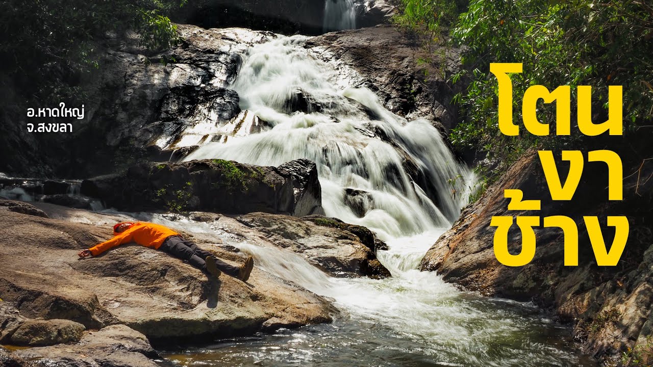
Ton Nga Chang Waterfall, Songkhla is one of the most important natural attractions in Hat Yai District, Songkhla Province. Located inside Ton Nga Chang Wildlife Sanctuary in Thung Tam Sao Subdistrict, this waterfall is widely known as one of the most beautiful waterfalls in Southern Thailand. Its defining feature is a seven-tier cascade set within humid evergreen forest. The most iconic tier is the third tier, called “Ton Nga Chang,” where the water separates into two streams that resemble a pair of elephant tusks. This natural shape gives the waterfall its name and makes the third tier the main highlight for visitors. The waterfall is about 26–28 km from central Hat Yai, making it practical for a half-day or full-day nature trip from the city.
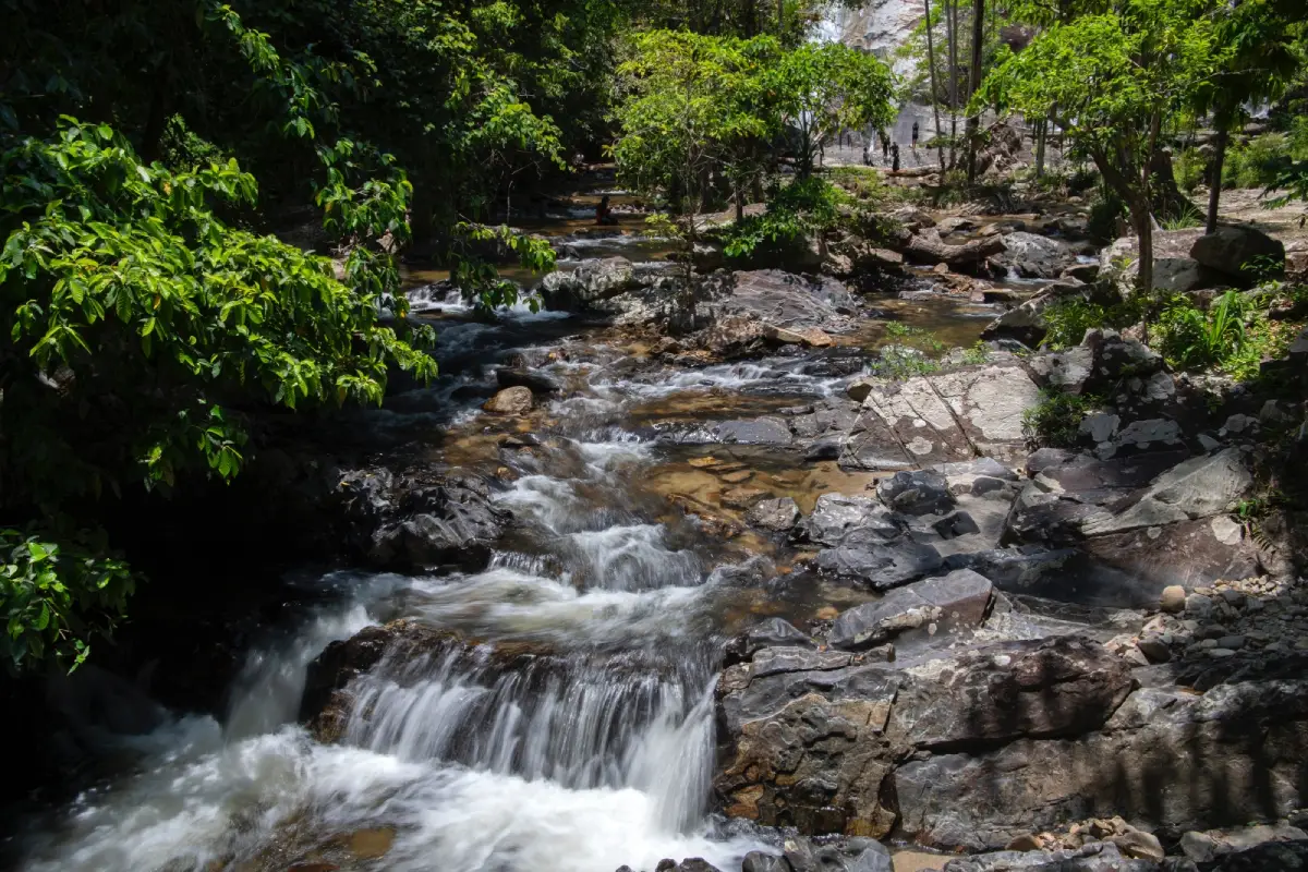
The appeal of Ton Nga Chang Waterfall goes beyond its scenic water flow. The waterfall sits within a protected wildlife sanctuary, so the surrounding forest plays an important role as a conservation area, a watershed, and a natural habitat for wildlife. The evergreen forest keeps the area cool and shaded, especially in the morning and after rainfall, when the water flow is stronger and the forest becomes especially fresh. The sound of water moving over rocks, the tall trees along the paths, and the natural stream setting make this place suitable for families, nature travelers, photographers, and visitors who want a real forest experience close to Hat Yai.
The word “Ton” is a southern Thai term for waterfall, while “Nga Chang” refers to elephant tusks. The name directly describes the appearance of the third tier, where two streams fall in a tusk-like shape over the rock face. When visitors reach the third tier, they see the feature that has made the waterfall famous: water flowing down natural stone into a pool below, framed by forest and large boulders. This is the main photography point and the most memorable part of the waterfall route.
Ton Nga Chang Waterfall has seven tiers, each with a different character. The first tier, Ton Ba, is close to the parking area and easy to reach. The second tier, Ton Pliw, has a natural pool and is popular for swimming because it is not difficult to access. The third tier, Ton Nga Chang, is the signature tier where the two streams form the elephant-tusk shape. The fourth tier, Ton Dam, the fifth tier, Ton Nam Ploi, the sixth tier, Ton Rue Si Khoi Bo, and the seventh tier, Ton Met Chun, are higher and deeper in the forest. These upper tiers involve steeper paths and are more suitable for physically prepared visitors with experience walking on natural terrain.
Most visitors spend their time around the lower tiers because they are easier to reach, more open, and better suited to families. The first and second tiers are practical for relaxing, taking photos, and entering the water only when conditions are safe. The third tier is best for visitors who want to see the waterfall’s most famous feature. The walk from the second tier to the third tier takes additional time and becomes steeper, so visitors should wear shoes with good grip and move carefully.
Walking through all seven tiers requires more time and physical effort than visiting the lower levels. Visitors should allow several hours for a fuller walk because parts of the trail are natural, with rocks, roots, wet ground, and uphill sections. Those planning to reach the higher tiers should start in the morning, avoid walking alone, avoid taking small children onto steep sections, and follow all instructions from wildlife sanctuary staff. During heavy rain or rising water levels, staff may restrict access to certain areas for safety.
The best time to visit is from morning to early afternoon. This gives visitors enough daylight for travel, walking, photography, and leaving the forest area before evening. Ton Nga Chang Waterfall can be visited year-round, but the experience changes by season. During and after the rainy season, the waterfall has stronger flow and the forest looks greener, but rocks can be slippery and water levels can rise quickly. During drier periods, walking is generally easier, the water is clearer, and the lower tiers are more comfortable for family recreation.
Main activities at Ton Nga Chang Waterfall include viewing the cascades, swimming only in safe and permitted areas, walking the nature trail, taking photos, resting by the stream, and enjoying the atmosphere of the evergreen forest. Families with children should stay close to the lower tiers and supervise children at all times. Elderly visitors or those who are not comfortable with steep paths should remain around the easier sections. Visitors taking photos on rocks should use dry, stable positions and avoid wet edges or areas with strong currents.
Useful items to bring include shoes with good grip, quick-dry clothing, spare clothes, a towel, a waterproof phone bag, drinking water, mosquito repellent, personal medicine, and cash for entry and parking fees. The waterfall area has some shops and visitor facilities, but bringing essential items makes the trip more comfortable, especially on busy days or when phone signal is unstable.
Visitor facilities include parking, toilets, food shops, small shops, rest areas, nature trails, accommodation units, and a camping area. However, Ton Nga Chang Waterfall is part of a wildlife sanctuary, not a commercial theme park. Visitors must use only permitted areas, stay on designated routes, avoid feeding wildlife, avoid touching animals, avoid collecting plants, and avoid activities that disturb the forest ecosystem.
Clean and responsible travel is essential because the waterfall is part of a watershed forest. Trash, food waste, foam containers, plastic, soap, and shampoo can affect water quality and stream life directly. Visitors should eat only in permitted areas, avoid taking food and drinks to upper tiers, and carry all trash back out. Responsible behavior protects the watershed and reduces the burden on sanctuary staff.
Getting There from central Hat Yai is straightforward. Take Phet Kasem Road on the Hat Yai–Rattaphum route. Around kilometer marker 13, turn left at Ban Hu Rae and continue along the access road for about 13 km to reach the Ton Nga Chang Wildlife Sanctuary office. The total distance from Hat Yai is about 26–28 km, and the drive normally takes about 30–40 minutes depending on traffic. The route is not complicated and has directional signs, but the final section should be driven carefully because it leads into a natural area with curves and more visitor traffic on holidays.
Visitors without a private car can travel from Hat Yai by local songthaew from the municipal market area or by hiring a tuk-tuk or local vehicle. Hiring a vehicle is convenient for groups or travelers carrying swimming gear because the return time can be arranged more easily. Visitors using public transport should check the return plan in advance and leave the waterfall before evening to avoid difficulty finding transportation back to Hat Yai.
Travelers starting from Hat Yai International Airport can use the Khuan Lang route and connect to Phet Kasem Road toward Rattaphum before turning toward Ban Hu Rae. This route works well for visitors who want to include the waterfall on a travel day because the waterfall is not far from the airport. Those staying in central Hat Yai can leave after breakfast, spend the late morning at the waterfall, and return to the city for food, markets, or evening activities.
A good trip plan depends on the visitor’s goal. For a relaxed visit, spend most of the time around tiers 1 and 2 and walk to tier 3 for the main highlight. For a longer walk through more tiers, start earlier, bring enough water, and avoid unnecessary baggage. Families with children, elderly visitors, or travelers who are not used to natural trails should focus on the safer lower zones and leave before late afternoon.
Ton Nga Chang Waterfall offers a broader experience than many smaller waterfalls because it has both easy lower tiers and more challenging upper tiers. The lower sections are suitable for relaxing and permitted water play, while the upper sections provide a stronger forest and hiking atmosphere. This variety makes the waterfall suitable for different visitor groups within the same destination.
The third tier deserves more time than the other tiers because it is the core image of Ton Nga Chang Waterfall. The two streams fall in a shape similar to elephant tusks, creating the feature that gives the place its name. It is an excellent viewpoint and photography spot, but visitors should watch their footing and avoid risky positions on wet rocks. On busy days, allow others to take photos in turn and avoid crowding narrow areas.
The fourth to seventh tiers feel deeper and more natural. The path becomes steeper and requires more effort than the lower sections. Visitors should assess their energy throughout the walk because descending also requires concentration. Natural forest paths can become slippery when damp, so walking slowly, using secure footing, and keeping distance from others are the safest approaches.
Ton Nga Chang Waterfall is suitable for a day trip from Hat Yai and can be combined with nearby places such as Ton Pliw Waterfall, Boriphat Waterfall Forest Park, Thara Sawan Waterfall, Duson Irrigation Weir, Yaroi Waterfall, or selected attractions in Hat Yai city. Still, the waterfall should be treated as the main activity of the day if visitors want to enjoy it properly, because waterfall walking requires more time and energy than a quick photo stop.
Compared with central Hat Yai, Ton Nga Chang Waterfall has a completely different character. The city is known for food, markets, cafés, and shopping, while the waterfall offers forest shade, cool water, and a protected watershed landscape. Combining both sides makes a Hat Yai trip more complete by connecting urban food culture with natural scenery that is genuinely close to the city.
Weather and water conditions are the most important safety factors. During continuous heavy rain, visitors should not enter the water or attempt higher tiers. Natural waterfalls can experience sudden strong currents and flash flooding. Visitors should observe water color, unusually loud water flow, floating branches or leaves, and staff warnings. If staff close a route or restrict an area, visitors should follow the instruction immediately.
On holidays, visitors should allow more time because Ton Nga Chang Waterfall is popular among Songkhla residents and travelers from Hat Yai. The lower tiers can become busier from late morning onward. Those who prefer a quieter visit should arrive early, prepare essentials in advance, and choose a resting spot that does not block walkways or shared spaces.
For families, Ton Nga Chang Waterfall is more accessible than many deep forest waterfalls in Southern Thailand because it has parking, shops, toilets, and lower tiers that are not difficult to reach. Even so, children must be supervised closely. They should wear non-slip shoes, avoid running on wet rocks, stay away from deep water, and remain close to adults at all times.
For photography, the most interesting scenes include filtered forest light, lower streams, natural pools, large boulders, and the two-stream cascade at the third tier. Visitors should use waterproof protection for phones and cameras because water spray and humidity can affect equipment. Safe positioning matters more than getting a dramatic angle.
Ton Nga Chang Waterfall is also an important place for learning about conservation. Visitors can see how a healthy forest protects water sources, stream clarity, natural pools, and the life around a humid watershed. A visit should therefore go beyond taking photos or swimming. Respecting wildlife sanctuary rules and reducing visitor impact are part of the experience.
For first-time visitors to Songkhla, Ton Nga Chang Waterfall is one of the most meaningful natural stops near Hat Yai. It is close to the city, has a distinctive seven-tier waterfall system, and has a clear identity through the elephant-tusk form at the third tier. Visitors can spend the morning at the waterfall and return to Hat Yai for Kim Yong Market, Khlong Hae Floating Market, Kho Hong Hill, or local food areas in the evening.
In summary, Ton Nga Chang Waterfall is one of the strongest nature attractions in Songkhla and Hat Yai. It offers a seven-tier waterfall, the iconic third-tier elephant-tusk cascade, shaded evergreen forest, basic visitor facilities, and convenient access from Hat Yai. Visitors should prepare properly, arrive early, watch for slippery ground and strong water, follow wildlife sanctuary rules, and keep the area clean so that Ton Nga Chang remains a valuable natural destination for Songkhla.
| Name | Ton Nga Chang Waterfall |
| Location | Ton Nga Chang Wildlife Sanctuary, Thung Tam Sao Subdistrict, Hat Yai District, Songkhla Province |
| Address | 48 Moo 7, Thung Tam Sao Subdistrict, Hat Yai District, Songkhla 90110, Thailand |
| Navigation Coordinates | 6.94975, 100.23408 |
| Highlights | A seven-tier waterfall inside Ton Nga Chang Wildlife Sanctuary. The third tier has two streams shaped like elephant tusks, making it the main highlight and the origin of the waterfall’s name. |
| Distinctive Features | Evergreen forest, clear streams, natural pools, a nature trail, easier lower tiers for rest and water play, and steeper upper tiers for physically prepared visitors |
| Waterfall Tiers | 1. Ton Ba 2. Ton Pliw 3. Ton Nga Chang 4. Ton Dam 5. Ton Nam Ploi 6. Ton Rue Si Khoi Bo 7. Ton Met Chun |
| Natural Importance | A waterfall within a protected wildlife sanctuary and an important watershed forest area of Songkhla Province |
| Travel Information | From central Hat Yai, take Phet Kasem Road on the Hat Yai–Rattaphum route. Around kilometer marker 13, turn left at Ban Hu Rae and continue for about 13 km to Ton Nga Chang Wildlife Sanctuary. Total distance is about 26–28 km from Hat Yai. |
| Current Status | Open as a natural attraction inside Ton Nga Chang Wildlife Sanctuary |
| Open Days | Daily |
| Opening Hours | 08.00 – 17.00 |
| Entrance Fee | Thai Visitors: Adult 20 Baht, Child 10 Baht; Car Parking 30 Baht |
| Facilities | Parking, toilets, food shops, small shops, rest areas, nature trail, accommodation units, and camping area |
| Main Areas / Zones | 1. Ton Nga Chang Wildlife Sanctuary Office 2. Parking And Visitor Service Area 3. Food Shops And Small Shops 4. Nature Trail 5. Tiers 1–2 For Rest And Water Play 6. Tier 3 Ton Nga Chang Main Highlight 7. Tiers 4–7 For Prepared Hikers |
| Caretaker | Ton Nga Chang Wildlife Sanctuary, Protected Area Regional Office 6 Songkhla |
| Wildlife Sanctuary Chief | Mr. Prasit Sathirawanich |
| Main Contact Number | Ton Nga Chang Wildlife Sanctuary, Tel. 074-894-804 |
| Nearby Tourist Attractions | 1. Boriphat Waterfall Forest Park, about 12 km 2. Ton Pliw Waterfall, about 19 km 3. Thara Sawan Waterfall, about 20 km 4. Duson Irrigation Weir, about 22 km 5. Yaroi Waterfall, about 23 km 6. Wat Kongkha Liap, about 24 km |
| Nearby Restaurants | 1. Suan Ton Restaurant, Ton Nga Chang, about 1 km, Tel. 085-670-3995, 087-969-4735 2. Wang Niang Thong Restaurant, about 4 km, Tel. 085-909-4415 3. Wang Rom Mueang Ton Nga Chang, about 5 km, Tel. 095-282-8799 4. Phung Kang Ban Hu Rae, about 13 km, Tel. 065-381-7411 5. Pa Toi Boat Noodles Hu Rae, about 13 km, Tel. 094-179-9815 6. BearHouse Ban Hu Rae, about 14 km, Tel. 095-458-5966 7. Moo Op Thang Ton Sai Ngam Ban Klang, about 16 km, Tel. 080-868-7532 |
| Nearby Accommodations | 1. Suan Kaew Homestay Ton Nga Chang, about 1 km 2. Thang Ton Resort, about 7 km, Tel. 083-183-2673 3. Pang Mai Resort, about 18 km, Tel. 074-390-249 4. Seree Grand Resort, about 18 km, Tel. 074-250-411 5. The Signature Hotel Airport, about 19 km, Tel. 074-255-566 6. Southern Airport Hotel, about 20 km, Tel. 074-802-038 7. 2U Hotel Hatyai, about 20 km, Tel. 074-536-209, 074-536-772 |
Frequently Asked Questions (FAQ)
Q: Where is Ton Nga Chang Waterfall located?
A: Ton Nga Chang Waterfall is located inside Ton Nga Chang Wildlife Sanctuary in Thung Tam Sao Subdistrict, Hat Yai District, Songkhla Province, about 26–28 km from central Hat Yai.
Q: What are the opening hours of Ton Nga Chang Waterfall?
A: Ton Nga Chang Waterfall is open daily from 08.00 to 17.00. Morning to early afternoon is the best time to visit because there is enough daylight for walking and returning safely.
Q: Is there an entrance fee for Ton Nga Chang Waterfall?
A: The Thai visitor fee is Adult 20 Baht and Child 10 Baht, with car parking at 30 Baht. Visitors should prepare cash for payment at the entrance service point.
Q: How many tiers does Ton Nga Chang Waterfall have?
A: Ton Nga Chang Waterfall has seven tiers: Ton Ba, Ton Pliw, Ton Nga Chang, Ton Dam, Ton Nam Ploi, Ton Rue Si Khoi Bo, and Ton Met Chun. The third tier is the most famous.
Q: Which tier is the main highlight of Ton Nga Chang Waterfall?
A: The third tier, Ton Nga Chang, is the main highlight because the water divides into two streams shaped like elephant tusks. This feature gives the waterfall its name.
Q: Can visitors swim at Ton Nga Chang Waterfall?
A: Visitors can swim only in safe and permitted areas, especially around the lower tiers and the second tier. Avoid entering the water during heavy rain or when the current is strong.
Q: Is the walk up Ton Nga Chang Waterfall difficult?
A: The lower tiers are not too difficult, but the route to the third tier and higher tiers becomes steeper. Visitors who want to reach several tiers should be physically prepared and wear shoes with good grip.
Q: How do I get to Ton Nga Chang Waterfall from Hat Yai?
A: From Hat Yai, take Phet Kasem Road on the Hat Yai–Rattaphum route. Around kilometer marker 13, turn left at Ban Hu Rae and continue for about 13 km to Ton Nga Chang Wildlife Sanctuary.
 Category: ●Nature and Wildlife
 Group: ●Waterfalls
Last Update : 2 MonthAgo
 Last Update : 2 MonthAgo
 Click to Access the Navigation Map GPS
Ton Nga Chang Waterfall Map
Recommend

 Art, Culture and Heritage
 Historical Sites and Monuments(2)
 Landmarks and Memorials(7)
 Royal Palace(1)
 Art, Craft Centres, Tradition(4)
 Museums(4)
 Art Gallery(1)
 Educational Places
 Library(1)
 Educational Gardens, Farm(3)
 Places of Worship
 Temple(52)
 Mosque(2)
 Other Sacred Sites(11)
 Suburban Living
 Village, Community(3)
 Local Market(3)
 Floating Market(2)
 National Parks and Marine Reserves(5)
 Mountain (Doi)(6)
 Dam, Reservoir, Lake(5)
Waterfalls(12)
 Caves(4)
 River, Canal(2)
 Bays and Beaches(13)
 Islands(3)
 Other natural attractions(2)
 Entertainment and Agricultural
 Zoos and Aquariums(2)
 Animal camps and shows(1)
 Farms, Parks and Ecotourism(6)
 Waterpark(1)
 Travel Articles, Recipes
 Travel Review, Food Review(1)
 Southern Food Menu, Southern Food Recipes(2)


