
lovethailand home >South Travel Attractions >Songkhla Travel Attractions >Muang Songkhla >Pha Wong > Tinsulanonda Bridge
TL;DR: Tinsulanonda Bridge is located at Connecting Ban Nam Krachai in Mueang Songkhla District, Ko Yo, and Ban Khao Khiao in Singhanakhon District, Songkhla Province, open Daily, hours 24 Hours.
Tinsulanonda Bridge
Open Days: Daily
Opening Hours: 24 Hours
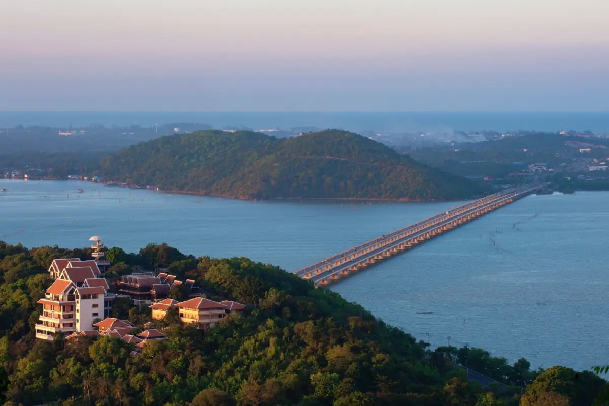
Tinsulanonda Bridge in Songkhla Province is one of the most important road bridges across Songkhla Lake. It connects Ban Nam Krachai on the Mueang Songkhla side with Ko Yo and continues to Ban Khao Khiao on the Singhanakhon side. The bridge forms part of Highway 4146, linking Highway 407 from Hat Yai to Songkhla with Highway 4083 from Songkhla to Ranot. It improved transport around Songkhla Lake, reduced dependence on vehicle ferries, and became a major landmark for travelers heading to Ko Yo, Wat Laem Pho, the Institute for Southern Thai Studies, and lakeside attractions around Songkhla.
Tinsulanonda Bridge is more than a road structure. It represents a major shift in Songkhla’s transport history. Before the bridge was built, people traveling between Mueang Songkhla, Ko Yo, Singhanakhon, and the northern lake districts relied heavily on vehicle ferries near Hua Khao Daeng. Waiting for ferries could be time-consuming, especially as road traffic increased. Once the bridge was completed, movement across Songkhla Lake became faster, more reliable, and better connected with the province’s wider road network.
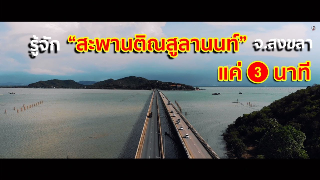
The bridge is divided into 2 main sections. The first section connects Ban Nam Krachai in Mueang Songkhla District with the southern side of Ko Yo. The second section connects the northern side of Ko Yo with Ban Khao Khiao in Singhanakhon District. Songkhla tourism information lists the first section, including approach areas, at about 1,140 meters and the second section at about 1,800 meters. Another local reference gives the main bridge spans as 940 meters and 1,700 meters, for a combined bridge length of about 2,640 meters. The difference comes from whether the measurement includes only bridge spans or also approach sections.
Construction of Tinsulanonda Bridge began on 26 March 1984, and the bridge was officially opened on 25 September 1986. It was named in honor of General Prem Tinsulanonda, who was Prime Minister of Thailand at the time and remained closely associated with Songkhla. Local people often call the bridge Saphan Tin, Saphan Pa Prem, Saphan Prem, or Ko Yo Bridge. These names show how deeply the bridge has entered local memory and daily language.
Geographically, the bridge stands in one of the most scenic parts of Songkhla. It crosses Songkhla Lake and passes through Ko Yo, an island known for orchards, fishing communities, woven textiles, temples, viewpoints, and lakeside restaurants. While driving across the bridge, visitors can see the broad surface of Songkhla Lake, local shoreline communities, Ko Yo, and the low hills that form the distinctive landscape of the lake region.
Songkhla Lake gives the bridge much of its identity. The lake is not just a body of water; it is a cultural and ecological landscape connected with fishing, farming, trade, transport, and community life in southern Thailand. Crossing Tinsulanonda Bridge is therefore not only a practical movement from one shore to another. It is a passage through a landscape where people, water, islands, livelihoods, and road networks meet.
The transport role of the bridge remains significant for travel between Mueang Songkhla, Ko Yo, Singhanakhon, Sathing Phra, and Ranot. It allows vehicles to move continuously without waiting for ferries and supports the movement of people, seafood, agricultural products, services, and tourism traffic. This improved connection has shaped the development of communities around Songkhla Lake and continues to support local mobility today.
For tourism, Tinsulanonda Bridge is the gateway to Ko Yo. Travelers driving from Songkhla city to Ko Yo cross the Ban Nam Krachai–Ko Yo section, and those continuing to Singhanakhon cross the Ko Yo–Ban Khao Khiao section. The bridge naturally introduces visitors to the lake landscape and to the cultural attractions that make Ko Yo one of Songkhla’s most memorable local destinations.
Ko Yo is closely tied to the bridge. The island offers Wat Laem Pho with its large reclining Buddha, the Institute for Southern Thai Studies with exhibitions on southern Thai culture, lakeside restaurants, viewpoints, local textiles, orchards, and fishing-community scenery. Because the bridge makes Ko Yo easy to reach, travelers can combine cultural learning, food, viewpoints, and lakeside photography in one route.
Another key nearby site is General Prem Tinsulanonda Historical Park, located near the bridge approach. The park includes the General Prem Tinsulanonda historical hall, public gardens, outdoor sculpture areas, mangrove learning zones, and an 800-meter nature walkway through a mangrove ecosystem. This makes the bridge area more than a drive-through point; it becomes part of a broader route combining modern history, public memory, local ecology, and lake scenery.
Visitors who want to photograph the bridge should choose safe viewpoints on Ko Yo, Wat Laem Pho, General Prem Tinsulanonda Historical Park, or lakeside restaurants and cafes. Stopping on the bridge is not recommended because it is an active highway with regular traffic. Viewing the bridge from land or from designated local spots is safer and usually provides better photographic angles.
The best times to experience Tinsulanonda Bridge are morning and late afternoon. The morning offers clear air and calmer conditions for driving around Ko Yo, while the late afternoon brings softer light over Songkhla Lake. Travelers who plan to visit several places should begin earlier in the day so they can cover Ban Nam Krachai, Ko Yo, and the Singhanakhon side without rushing.
For visitors interested in modern local history, Tinsulanonda Bridge is a clear example of how infrastructure changed Songkhla. The bridge transformed a ferry-dependent crossing into a continuous road route. It made Ko Yo easier to reach, opened the area to more visitors, and improved access between communities, markets, schools, services, and tourism businesses around the lake.
One of the bridge’s strongest impressions is the feeling of driving across open water. The lake spreads out on both sides, the road leads toward Ko Yo, and the views change as the vehicle moves from mainland to island and then toward the far shore. This makes the bridge different from a typical road crossing. It turns a normal journey into a visual experience of Songkhla’s lake landscape.
A visit should be planned together with nearby attractions because the bridge itself is an active traffic route, not a pedestrian promenade. Good stopping points are on Ko Yo and near the bridge approaches. Travelers can start from Songkhla city, cross from Ban Nam Krachai to Ko Yo, visit Wat Laem Pho and the Institute for Southern Thai Studies, then either return the same way or continue to Singhanakhon and the Songkhla–Ranot route.
A half-day itinerary can begin at General Prem Tinsulanonda Historical Park, continue across the bridge to Ko Yo, stop at Wat Laem Pho, visit the Institute for Southern Thai Studies, and end with a lakeside meal. This route is suitable for travelers who have limited time but want to experience the bridge, lake scenery, temples, southern Thai culture, and local food in one trip.
With a full day, travelers can extend beyond Ko Yo toward Singhanakhon, Sathing Phra, or Ranot. This longer route is suitable for those interested in historic temples, fishing communities, lake ecology, and the wider cultural geography of Songkhla Lake. In that sense, Tinsulanonda Bridge is not only a landmark but also a useful starting point for deeper travel around the lake basin.
From Songkhla city, travelers can take Kanchanawanit Road or Highway 407 toward Ban Nam Krachai and enter Highway 4146 to cross the bridge. From Hat Yai, use Lopburi Ramesuan Road or Kanchanawanit Road toward Mueang Songkhla, then continue toward the bridge. From Singhanakhon or Ranot, use Highway 4083 and enter the Ban Khao Khiao side before crossing toward Ko Yo and Mueang Songkhla.
Traveling by private car is the most convenient option because attractions around Ko Yo are spread across different areas. Travelers without a car can use local transport from Songkhla city to Ko Yo, but they should check local pickup points and timing before traveling, as service frequency may vary by day and route.
Safety matters when visiting Tinsulanonda Bridge. It is a working highway, so drivers should not stop on the bridge, take photos while driving, or obstruct traffic. For photography, use viewpoints, restaurants, temple grounds, or safe roadside areas away from moving vehicles. Respecting traffic rules keeps the visit safe for both travelers and local road users.
The bridge also supports the local economy. Easier road access helps restaurants, cafes, homestays, textile producers, fishing communities, and cultural sites on Ko Yo and nearby areas. Travelers crossing the bridge often continue to spend time and money in local businesses, spreading tourism benefits across the lake communities.
In cultural travel terms, Tinsulanonda Bridge helps visitors understand Songkhla as a lake city, not only a beach or old-town destination. Songkhla includes freshwater and brackish-water landscapes, lake islands, fishing communities, temples, local food, and modern transport history. The bridge brings these elements together in a single route.
For photography, the best views are often from higher points on Ko Yo, lakeside restaurants, Wat Laem Pho, and General Prem Tinsulanonda Historical Park. These locations allow visitors to capture the bridge, lake, island, and surrounding landscape in one frame. Late afternoon light creates a softer mood, while morning offers a cleaner and calmer view.
Tinsulanonda Bridge is valuable because it connects many layers of Songkhla: infrastructure, the legacy of General Prem Tinsulanonda, Songkhla Lake, Ko Yo’s community life, and the tourism route around the lake. Crossing this bridge is not only a movement across water. It is a journey through a landscape that holds the memory, development, and beauty of Songkhla in one continuous line.
| Name | Tinsulanonda Bridge |
| Location | Connecting Ban Nam Krachai in Mueang Songkhla District, Ko Yo, and Ban Khao Khiao in Singhanakhon District, Songkhla Province |
| Address | Highway 4146, linking Phawong Subdistrict, Ko Yo Subdistrict, and the Singhanakhon side of Songkhla Province |
| Coordinates | Reference coordinates: 7.154444, 100.559167 |
| Highlights | A major bridge across Songkhla Lake connecting Songkhla city, Ko Yo, and Singhanakhon, with scenic lake views and access to Ko Yo attractions |
| History / Period | Construction began on 26 March 1984, and the bridge was officially opened on 25 September 1986 |
| Name Origin | Named in honor of General Prem Tinsulanonda, Prime Minister of Thailand at the time and a major figure closely associated with Songkhla |
| Distinctive Features | Divided into 2 sections: Ban Nam Krachai–Ko Yo and Ko Yo–Ban Khao Khiao, forming part of Highway 4146 between Highway 407 and Highway 4083 |
| Length | The 2 bridge spans total about 2,640 meters; provincial tourism information lists about 1,140 meters for the first section including approaches and about 1,800 meters for the second section |
| Main Areas / Zones | Ban Nam Krachai–Ko Yo bridge section, Ko Yo area, Ko Yo–Ban Khao Khiao bridge section, Ko Yo viewpoints, and the bridge approach near General Prem Tinsulanonda Historical Park |
| Travel Information | From Songkhla city, take Kanchanawanit Road or Highway 407 toward Ban Nam Krachai, then enter Highway 4146 to cross toward Ko Yo and Singhanakhon |
| Current Status | Open as a public highway and a major tourism route connecting Songkhla city, Ko Yo, and Singhanakhon District |
| Open Days | Daily |
| Opening Hours | 24 Hours |
| Fees | No Admission Fee |
| Facilities | Road access to Ko Yo, nearby viewpoints, lakeside restaurants, cafes, community attractions, and learning sites near the bridge approach |
| Caretaker / Related Agency | Department of Highways |
| Main Contact Number | Department of Highways Hotline, Tel. 1586 |
| Nearby Tourist Attractions | 1. Ko Yo, 1 km 2. Wat Laem Pho, 1 km 3. General Prem Tinsulanonda Historical Park, 2 km, Tel. 074-330-267 4. Institute for Southern Thai Studies, 4 km, Tel. 074-591611-2, 093-5758827 5. Ban Sattha, 4 km 6. Kanchanaphisek Songkhla National Library, 4 km, Tel. 074-333-063-5 |
| Nearby Restaurants | 1. 89 Eighty Nine Coffee&Eatery, 2 km, Tel. 088-636-2464 2. Nam Kieng Din Ko Yo, 3 km, Tel. 082-179-9709 3. Mahadsajan Ko Yo Restaurant, 4 km, Tel. 095-632-4466 4. Ko Yo De Lagoon Restaurant, 4 km, Tel. 074-847956, 081-8533447, 090-6762404 5. Sirada Restaurant Ko Yo, 5 km, Tel. 074-591-595, 074-450-235, 081-963-8135 6. Nam Ta Son Fresh Rice Noodles, 6 km, Tel. 081-277-2424, 086-284-4920 |
| Nearby Accommodations | 1. The Hill Resort, 2 km, Tel. 074-370483 2. The Lake House, 3 km, Tel. 086-965-2382 3. Ko Yo Resort, 4 km, Tel. 086-966-4862 4. Greenery Hill Resort @ Koyo, 4 km, Tel. 082-889-9941 5. Rueanraek Homestay Ko Yo, 6 km, Tel. 081-898-3341 6. Choblay Homestay, 6 km, Tel. 089-466-4048 |
Frequently Asked Questions (FAQ)
Q: Where is Tinsulanonda Bridge located?
A: Tinsulanonda Bridge is located in Songkhla Province. It connects Ban Nam Krachai in Mueang Songkhla District with Ko Yo and continues to Ban Khao Khiao in Singhanakhon District.
Q: What are the opening hours of Tinsulanonda Bridge?
A: Tinsulanonda Bridge is a public highway and is open daily, 24 hours.
Q: Why was Tinsulanonda Bridge built?
A: It was built to improve transport across Songkhla Lake, reduce waiting time for vehicle ferries, and connect Songkhla city, Ko Yo, and Singhanakhon more efficiently.
Q: How long is Tinsulanonda Bridge?
A: The 2 bridge spans total about 2,640 meters. Provincial tourism information also lists about 1,140 meters for the first section including approaches and about 1,800 meters for the second section.
Q: How is Tinsulanonda Bridge related to Ko Yo?
A: The bridge connects Ko Yo with both Ban Nam Krachai and Ban Khao Khiao, making the island easy to reach and turning it into a key tourism route around Songkhla Lake.
Q: Can visitors stop on the bridge for photos?
A: Stopping on the bridge is not recommended because it is an active highway. Visitors should take photos from Ko Yo viewpoints, lakeside restaurants, temple areas, or safe spaces near the bridge approach.
Q: Which nearby attractions pair well with Tinsulanonda Bridge?
A: Good nearby stops include Ko Yo, Wat Laem Pho, General Prem Tinsulanonda Historical Park, the Institute for Southern Thai Studies, Ban Sattha, and Kanchanaphisek Songkhla National Library.
Q: What is the best time to view Tinsulanonda Bridge?
A: Morning and late afternoon are the best times because the weather is more comfortable, the light is softer, and views of Songkhla Lake, Ko Yo, and the bridge are clearer from nearby viewpoints.
 Category: ●Art, Culture and Heritage
 Group: ●Landmarks and Memorials
Last Update : 2 MonthAgo
 Last Update : 2 MonthAgo
 Click to Access the Navigation Map GPS
Tinsulanonda Bridge Map
Recommend

 Historical Sites and Monuments(2)
Landmarks and Memorials(7)
 Royal Palace(1)
 Art, Craft Centres, Tradition(4)
 Museums(4)
 Art Gallery(1)
 Educational Places
 Library(1)
 Educational Gardens, Farm(3)
 Places of Worship
 Temple(52)
 Mosque(2)
 Other Sacred Sites(11)
 Suburban Living
 Village, Community(3)
 Local Market(3)
 Floating Market(2)
 Nature and Wildlife
 National Parks and Marine Reserves(5)
 Mountain (Doi)(6)
 Dam, Reservoir, Lake(5)
 Waterfalls(12)
 Caves(4)
 River, Canal(2)
 Bays and Beaches(13)
 Islands(3)
 Other natural attractions(2)
 Entertainment and Agricultural
 Zoos and Aquariums(2)
 Animal camps and shows(1)
 Farms, Parks and Ecotourism(6)
 Waterpark(1)
 Travel Articles, Recipes
 Travel Review, Food Review(1)
 Southern Food Menu, Southern Food Recipes(2)


