
lovethailand home >North Travel Attractions >Uttaradit Travel Attractions > 40 Places to Visit in Uttaradit Northern Thailand
TL;DR: 40 Places to Visit in Uttaradit Northern Thailand, open Daily Opening Hours: 09:00 – 16:00.
40 Places to Visit in Uttaradit Northern Thailand
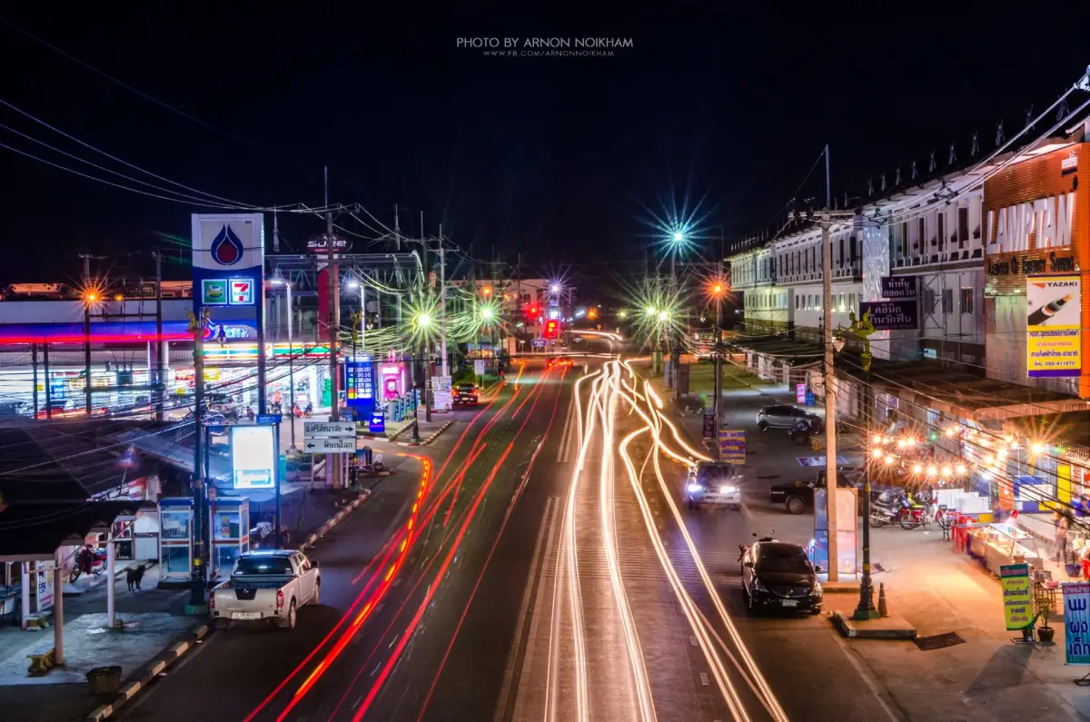
40 Places to Visit in Uttaradit: Must-See Attractions in Northern Thailand Uttaradit is a lower northern province where nature, history, spirituality, old communities, and local ways of life come together in a distinctive way. Its highlights range from Phu Soi Dao National Park for serious hikers and Sirikit Dam and the Nan River basin for travelers who enjoy mountain and reservoir scenery, to Laplae for culture and local food, as well as the Phraya Phichai Dap Hak Monument and the historic Buddhist sites around Thung Yang. If you have only 1 day, focus on Uttaradit city or the Laplae area. With 2–3 days, add Sirikit Dam, Mae Phun Waterfall, Nam Phi Iron Wells, and Ton Sak Yai Forest Park. With 4–5 days or more, include Phu Soi Dao and the nature routes around Nam Pat and Ban Khok to experience a much broader side of Uttaradit.
Uttaradit lies at the transition between upper and lower northern Thailand. The Nan River is the province’s major waterway, while the landscape ranges from river plains and agricultural land to rolling hills and high mountain ranges in the east and northeast. This variety allows travelers to experience old towns, temples, historic sites, waterfalls, dams, national parks, forests, and mountain communities within a single province.
Uttaradit has a long history of settlement and once played an important role in transportation along the Nan River. The Bang Pho–Tha It community developed as a river port and trading point connecting northern towns with central Thailand before eventually growing into modern Uttaradit. The name Uttaradit is historically associated with the idea of a northern port or landing place, reflecting the city’s long-standing importance in trade and travel.
Another major part of Uttaradit’s identity is the story of Phraya Phichai Dap Hak, the celebrated warrior known for his courage and loyalty to King Taksin the Great. His story has become one of the defining symbols of the province, and the Phraya Phichai Dap Hak Monument in the city remains an important place where visitors come to pay respect and learn about local history.
Laplae District is another area that strongly shapes the image of Uttaradit through its legends, old communities, important temples, and hillside agricultural lifestyle. The district is especially famous for langsat, longkong, and the distinctive Long Laplae and Lin Laplae durian varieties, as well as local cuisine with its own character. Visiting Laplae is therefore not only about following the legend of the “hidden town,” but also about experiencing a small northern community where culture, food, fruit farming, and local history remain closely connected.
For travelers interested in Buddhist heritage, the Thung Yang–Laplae route includes several important religious sites such as Wat Phra Borommathat Thung Yang, Wat Phra Yuen Phutthabat Yukhon, and Wat Phra Thaen Sila At. These sites are located relatively close to one another and can be combined into a one-day pilgrimage route featuring sacred relics, Buddha footprints, and religious objects that have been revered by local communities for generations.
For nature lovers, Phu Soi Dao is one of the province’s most outstanding destinations, particularly for trekkers who want to reach the Three-Needle Pine Plateau, see seasonal wildflower fields, mist, pine forest, and cool highland weather. Travelers seeking easier access to nature can instead visit Mae Phun Waterfall, Ton Sak Yai Forest Park, or explore the routes around Sirikit Dam and Lam Nam Nan National Park.
Sirikit Dam and its vast reservoir form the center of tourism in Tha Pla District. The broad body of water is surrounded by mountains and connected to waterfront communities, boat routes, and Lam Nam Nan National Park. This makes the area suitable for families, photographers, nature travelers, and visitors who prefer a slower journey with scenic stops.
Another distinctive identity of Uttaradit is Nam Phi iron from Thong Saen Khan District. The material has long been associated with weapon making, craftsmanship, and traditional beliefs. Nam Phi Iron Wells therefore serve as a learning destination where visitors can explore local metallurgy, history, and cultural knowledge that is quite different from the province’s temples and waterfalls.
Food and souvenirs in Uttaradit are closely connected to local agriculture and natural resources. Laplae is especially known for langsat, longkong, Long Laplae durian, and Lin Laplae durian, together with local dishes, traditional snacks, and community products. Travelers visiting during fruit season can easily combine orchards, local communities, markets, and Mae Phun Waterfall into the same trip.
When planning a trip to Uttaradit, dividing the itinerary into geographic zones is the most practical way to reduce driving time. The city zone is best for history and monuments. Laplae–Thung Yang is ideal for temples, old communities, fruit, and waterfalls. Tha Pla–Nam Pat is suitable for dams, forests, reservoirs, and giant teak. Phu Soi Dao should generally be treated as a separate trip because it requires considerably more travel time, physical preparation, and advance planning than ordinary sightseeing destinations.
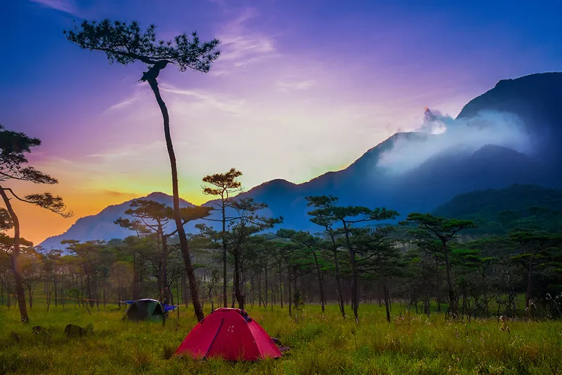
1. Phu Soi Dao National Park is one of the most famous mountain and trekking destinations in lower northern Thailand. The park covers parts of Uttaradit and Phitsanulok provinces, with important areas in Nam Pat, Ban Khok, and Chat Trakan districts. Its best-known features include Phu Soi Dao Peak at approximately 2,102 metres above sea level, the Three-Needle Pine Plateau, seasonal wildflower fields, waterfalls, and a challenging trekking route that attracts hikers from across Thailand.
Highlights: Three-Needle Pine Plateau at approximately 1,633 metres above sea level, seasonal Murdannia gigantea flower fields during the rainy season, Phu Soi Dao Waterfall, Sai Thip Waterfall, pine forest, high mountains, camping, and an approximately 6.5-kilometre trekking route.
Phu Soi Dao is an important watershed forest with diverse ecosystems ranging from montane forest and pine forest to dry evergreen forest, mixed deciduous forest, and high-altitude grassland. The landscape changes dramatically with the seasons. During the rainy season, the mountain becomes lush and the plateau is covered with wildflowers, while the cool season brings colder air, mist, and the quiet atmosphere of pine forest.
The area was first established as Phu Soi Dao Forest Park in 1990 before additional forest areas were surveyed and later developed into a national park. Its protected status reflects the importance of the mountain not only for tourism but also for forest conservation, watershed protection, biodiversity, and ecological recovery.
The Three-Needle Pine Plateau is the main destination for hikers. Located at approximately 1,633 metres above sea level and covering more than 1,000 rai, the plateau consists of pine forest, grassland, rolling hills, and wide open spaces. It is the main camping area and one of the best locations for experiencing mist, seasonal flowers, mountain light, and clear night skies.
The trek to the plateau begins near Phu Soi Dao Waterfall along Highway 1268. The trail is approximately 6.5 kilometres long and generally takes around 4–6 hours. Several sections are steep, including well-known climbs such as Noen Song Yat, Noen Prap Sian, and Noen Morana. Hikers should prepare their physical condition, trekking shoes, drinking water, rain protection, and lightweight baggage carefully before starting the ascent.
Visitors who do not want to hike to the plateau can still enjoy Phu Soi Dao Waterfall near the park service area. The waterfall has 5 tiers and is much easier to access, making it suitable for families and travelers who want to experience the mountain forest without completing the full trek. Those heading to the plateau should normally plan to stay overnight and confirm current trekking conditions before departure.
August to September is especially famous for seasonal wildflowers, including Murdannia gigantea and other highland species growing across the pine plateau. However, this period falls within the rainy season, so trails can become muddy and slippery and mountain weather can change rapidly. Rain gear and careful attention to official park announcements are therefore essential.
Getting There: From Uttaradit city, travel toward Nam Pat and Ban Khok districts before continuing to Highway 1268 toward Phu Soi Dao National Park. Travelers planning to trek to the pine plateau should arrive early and contact park staff before beginning the route.

2. Sirikit Dam is located near Ban Pha So in Pha Lueat Subdistrict, Tha Pla District. This massive earth-fill dam with a clay core blocks the Nan River and plays a major role in water management, hydroelectric power generation, irrigation, and flood control. At the same time, it is one of Uttaradit’s most important scenic attractions.
Highlights: Large earth-fill dam, vast reservoir, views of the Nan River and surrounding mountains, viewpoints, recreational areas, boat trips, and routes connecting waterfront communities.
Sirikit Dam was constructed as part of the development of the Nan River basin. It was originally known as Pha So Dam before receiving the royal name Sirikit Dam. The crest is approximately 810 metres long, about 12 metres wide, and approximately 113.60 metres high, making the dam one of Thailand’s major water and energy infrastructure projects.
The reservoir extends across a broad mountainous landscape. From the dam crest and nearby viewpoints, visitors can see long stretches of water framed by mountain ridges, with boats and floating structures appearing across the reservoir. The scenery is especially attractive in the morning and late afternoon.
Beyond electricity generation, water stored behind the dam supports agriculture, dry-season water supply, and flood management. For this reason, Sirikit Dam is also an educational destination where travelers can understand the relationship between rivers, energy, agriculture, water management, and local communities.
Travelers can combine the dam with Ban Tha Ruea, Ban Huai Ta, Lam Nam Nan National Park, and Ton Sak Yai Forest Park. With 1–2 days, the Tha Pla–Nam Pat area works particularly well for a scenic driving itinerary focused on forests, reservoirs, communities, and river landscapes.
Families, older travelers, and photographers can explore the dam area relatively easily. Boat trips and visits to communities around the reservoir may depend on water levels and local operators, so these activities should be arranged or confirmed in advance.
Getting There: From Uttaradit city, take Highway 1045 toward Tha Pla District and Sirikit Dam. The distance is approximately 40–50 kilometres depending on the starting point in the city. A private car is the most convenient option for continuing to other attractions around Tha Pla and Nam Pat.
Map (GPS):Open Directions to Sirikit Dam
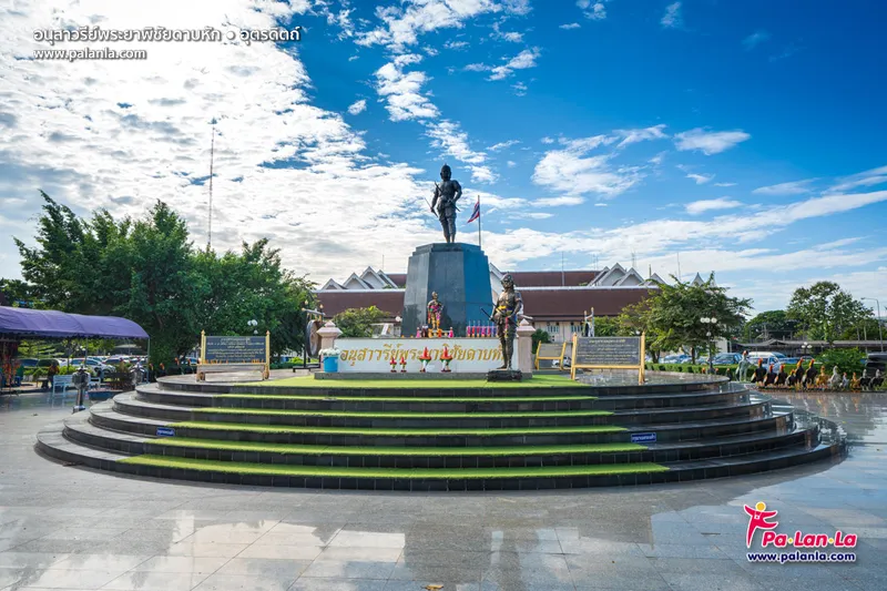
3. Phraya Phichai Dap Hak Monument stands in front of Uttaradit Provincial Hall in Mueang Uttaradit District. The monument commemorates Phraya Phichai Dap Hak, the celebrated warrior remembered for his bravery and unwavering loyalty to King Taksin the Great.
Highlights: Monument to Uttaradit’s most famous warrior, the legendary battle in which his sword broke, a symbol of local courage, and an excellent starting point for understanding the province’s history.
Phraya Phichai Dap Hak was originally named Choi and came from the historic town of Phichai. He developed exceptional fighting skills before entering the service of King Taksin the Great, eventually becoming one of the king’s trusted military commanders.
The event that made his name legendary occurred during the defense of Phichai. During intense fighting, one of his swords broke, but he continued the battle using his remaining weapon until victory was secured. The incident gave rise to the title “Phraya Phichai Dap Hak,” meaning Phraya Phichai of the Broken Sword.
For the people of Uttaradit, his story is more than an account of war. It represents courage, loyalty, responsibility, and sacrifice for the country. His name and story continue to appear in local cultural activities and educational programs throughout the province.
The area around the monument is suitable for paying respect, taking photographs, and beginning a city sightseeing route. Several museums, temples, government landmarks, and historic sites are located within easy reach.
Families traveling with children or students can use the monument as an accessible introduction to local history before continuing to Phichai District, where more places connected with the warrior’s life and memory can be explored.
Open Days: Daily Opening Hours: 09:00 – 16:00
Getting There: The monument stands in front of Uttaradit Provincial Hall on Phat Sanambin Road, Tha It Subdistrict, Mueang Uttaradit District. It is easily reached from Uttaradit Railway Station and the city center by car, motorcycle, or local transport.

4. Nam Phi Iron Wells are located at Ban Nam Phi in Nam Phi Subdistrict, Thong Saen Khan District. The site is an important center for learning about the history of metallurgy and traditional local knowledge. Nam Phi iron has long been famous for its strength and its use in weapons, tools, sacred objects, and amulets.
Highlights: Ancient iron pits, famous Nam Phi iron, traditional weapon-making knowledge, metallurgy, and exhibitions related to local beliefs and history.
The Nam Phi area contains evidence of iron extraction and use dating back many generations. The metal became so famous that the phrase “renowned Nam Phi iron” is included in the provincial identity of Uttaradit and remains strongly associated with the production of swords and other traditional weapons.
The attraction is not limited to viewing the old iron pits. Visitors can also learn about the traditional process from natural ore selection and smelting to forging and shaping, providing insight into the technical knowledge and craftsmanship of earlier generations.
Nam Phi iron is also connected with traditional beliefs regarding sacred power and protective qualities. It has therefore been used to create Buddha images, amulets, sacred objects, and ceremonial items in different periods, making the site interesting for travelers interested in history, craftsmanship, metallurgy, and folk belief.
Families with children can use Nam Phi Iron Wells as an outdoor learning destination because the site connects science, history, technology, local wisdom, and community life in an accessible way.
A visit to Thong Saen Khan can take half a day or a full day. Travelers can also stop at local shops or community producers to see how traditional Nam Phi iron knowledge has been adapted into contemporary products.
Open Days: Daily Opening Hours: 08:00 – 17:00
Getting There: From Uttaradit city, travel toward Thong Saen Khan District and continue to Nam Phi Subdistrict and Ban Nam Phi. The distance is approximately 50–60 kilometres from the city center, and a private car is the most convenient option.
Map (GPS):Open Directions to Nam Phi Iron Wells

5. Mae Phun Waterfall is located at Ban Ton Kluea in Mae Phun Subdistrict, Laplae District. It is one of the easiest and most popular waterfalls to reach in Uttaradit, thanks to its location close to Laplae town and the presence of local restaurants, souvenir shops, and recreational areas nearby.
Highlights: Easily accessible waterfall near Laplae, shaded surroundings, relaxed picnic atmosphere, local food, and a route that can be combined with Laplae town and fruit orchards in a single day.
Mae Phun Waterfall consists of water flowing over rock formations within a landscaped area designed for relatively easy access. Its appeal is therefore different from that of a remote jungle waterfall: it offers a convenient natural setting close to a living community and is suitable for visitors of many ages.
The area around the waterfall is humid and shaded, especially during and after the rainy season when water levels are higher. It is a good place to sit, eat, rest, and spend time outdoors without the physical demands of a long trek.
Mae Phun Waterfall is closely connected with Laplae’s agricultural landscape. The surrounding roads pass orchards and communities known for langsat, longkong, Long Laplae durian, and Lin Laplae durian. During fruit season, travelers can easily combine local food, orchard products, and nature in a single itinerary.
During periods of heavy rain, visitors should be careful around slippery rocks and changing water levels. Swimming should be avoided where the current is strong or outside designated safe areas.
The waterfall can be combined with the Phra Si Phanommat Monument, Laplae town, Wat Phra Borommathat Thung Yang, Wat Phra Yuen Phutthabat Yukhon, and Wat Phra Thaen Sila At, making the Laplae area suitable for a full-day trip.
Open Days: Daily Opening Hours: 08:00 – 17:00
Getting There: From Uttaradit city, travel toward Laplae District and continue to Mae Phun Subdistrict and Ban Ton Kluea. The route is accessible by ordinary cars and is well connected to the main roads around Laplae.
Map (GPS):Open Directions to Mae Phun Waterfall

6. Ton Sak Yai Forest Park is located at Ban Pang Kluea in Nam Khrai Subdistrict, Nam Pat District. The protected area is famous for an exceptionally large teak tree that has become one of Uttaradit’s best-known natural symbols and is closely connected with the province’s reputation as the home of giant teak.
Highlights: Ancient giant teak tree, short forest walking routes, botanical learning, conservation history, and the natural environment of Nam Pat District.
The giant teak tree represents the historic richness of northern Thailand’s forests. Its massive trunk immediately conveys the extraordinary time required for teak to grow to such dimensions and offers visitors a direct sense of the scale of old-growth forest.
The surrounding area is managed as a forest park with walking paths and zones for environmental learning. It is suitable for families, students, photographers, and visitors interested in forestry who do not want to undertake a long or difficult trek.
Visiting the giant teak also highlights the importance of forest conservation. Trees of this age and size cannot be replaced within a short period and play an important role in local ecosystems, moisture retention, soil stability, and wildlife habitat.
Ton Sak Yai Forest Park can be combined with Sirikit Dam, Lam Nam Nan National Park, and the Nam Pat route. It is particularly suitable for travelers who want a nature-focused itinerary with relatively little walking.
Morning is generally the most comfortable time to walk through the area because temperatures are cooler and filtered sunlight through the canopy creates attractive conditions for forest photography.
Open Days: Daily Opening Hours: 06:00 – 18:00
Getting There: From Uttaradit city, travel toward Tha Pla and Nam Pat districts, then continue to Nam Khrai Subdistrict and Ban Pang Kluea. A private car is the most convenient option and makes it easy to combine the park with Sirikit Dam.

7. Wat Phra Borommathat Thung Yang is located at Ban Thung Yang in Thung Yang Subdistrict, Laplae District. It is one of Uttaradit’s most important Buddhist sites and a central stop on the Thung Yang–Phra Thaen Sila At–Laplae pilgrimage route.
Highlights: Sacred relic chedi, architecture reflecting links between Sukhothai and Lanna traditions, long-standing community faith, and a convenient location near Wat Phra Yuen Phutthabat Yukhon and Wat Phra Thaen Sila At.
Thung Yang is an old community with an important place in the cultural landscape of Uttaradit. Wat Phra Borommathat Thung Yang therefore serves both as a religious center and as evidence of the area’s long historical continuity.
The sacred chedi is the spiritual center of the temple. Visitors come to pay respect to the Buddhist relics and to observe the artistic details of the chedi and surrounding religious buildings.
The temple’s importance extends beyond architecture. Local legends, religious beliefs, and community traditions remain closely connected with the site, and residents continue to maintain the temple and organize annual merit-making activities.
Travelers can use this temple as the starting point for a Buddhist heritage route before continuing to Wat Phra Yuen Phutthabat Yukhon and Wat Phra Thaen Sila At, then heading into Laplae town.
Those interested in architecture and history should allow enough time to walk around the temple carefully. The surrounding religious landscape reflects the meeting of lower northern Thai traditions with artistic influences from both Sukhothai and Lanna.
Open Days: Daily Opening Hours: 08:00 – 17:00
Getting There: From Uttaradit city, take Highway 102 toward Laplae District and Thung Yang Subdistrict. The temple is located within Ban Thung Yang and can easily be combined with nearby temples.

8. Lam Nam Nan National Park covers areas of Tha Pla District in Uttaradit and extends into neighboring Phrae Province. The protected landscape combines mountains, forests, the Nan River, reservoir scenery, and viewpoints, making it ideal for travelers who want a quieter nature experience around Sirikit Dam.
Highlights: Nan River watershed forest, mountains and reservoir landscapes, viewpoints, nature around Sirikit Dam, camping, and routes connecting the Tha Pla area.
The park consists of complex mountain terrain in which the Nan River is a central ecological feature. The landscape includes dry forest, deciduous forest, and more humid areas influenced by rivers, streams, and reservoir conditions.
The creation of Sirikit Dam transformed part of the landscape into a large reservoir, producing distinctive views where broad stretches of water run between mountain ranges. Visitors can therefore observe both natural scenery and the effects of large-scale water management within the same region.
The national park is suitable for relaxing, photography, nature study, viewpoint visits, and camping in designated areas. Visitors who do not want to undertake long hikes can still experience the mountain and reservoir environment relatively easily.
Lam Nam Nan National Park can be combined with Sirikit Dam, Ton Sak Yai Forest Park, Ban Tha Ruea, and communities around the reservoir. This gives the Tha Pla–Nam Pat zone a particularly rich mix of forest, dam, community life, and waterfront scenery.
The rainy season brings lush green landscapes but can also make mountain roads slippery. The cool season is popular for overnight stays because temperatures are more comfortable and visibility is often better.
Open Days: Daily Opening Hours: 06:00 – 20:00
Getting There: From Uttaradit city, take Highway 1045 toward Sirikit Dam, Tha Pla District, and Pha Lueat Subdistrict, then follow local signs into the national park. A private car is the most convenient form of transportation.

9. Phra Si Phanommat Monument is located at the market intersection in Si Phanommat Subdistrict, Laplae District. The monument commemorates an important local figure who played a major role in the development of Laplae and serves as one of the best starting points for exploring the old community.
Highlights: Important historical figure of Laplae, central location in the community, Laplae market, old-town routes, and convenient connections to the Laplae city gate, local museum, and Mae Phun Waterfall.
Phra Si Phanommat is remembered by local residents for his contributions to the development, administration, and organization of Laplae. His name remains part of the townscape through the name of Si Phanommat Subdistrict and through the continuing memory of the community.
The monument stands in the middle of an active commercial area, so local history is experienced alongside everyday life. Markets, food stalls, shops, and houses surround the site, allowing visitors to pay respect at the monument and then immediately continue into the atmosphere of Laplae.
Laplae is well known for legends about the hidden town and traditional ideas about honesty and keeping one’s word. Visiting the actual community, however, reveals many additional layers including local administration, agriculture, historical personalities, food, and social development.
From the monument, travelers can continue to the Laplae city gate, local museums, markets, traditional neighborhoods, and fruit-growing areas before heading toward Mae Phun Waterfall. This route combines history, food, community life, and nature in one day.
Morning is a good time to explore the market and try local food, while late morning and afternoon can be used for temples and the waterfall. During fruit season, additional time should be allowed for orchard products and community shops.
Getting There: From Uttaradit city, travel toward Laplae District and enter Si Phanommat Subdistrict. The monument is located at the main market intersection and is a convenient center point for continuing to other attractions around Laplae.

10. Wat Phra Yuen Phutthabat Yukhon is located in Thung Yang Subdistrict, Laplae District, on the same route as Wat Phra Borommathat Thung Yang and Wat Phra Thaen Sila At. Its most important features are a pair of sacred Buddha footprints housed within a mondop and Luang Pho Phuttha Rangsi, a bronze Buddha image in the Sukhothai artistic style.
Highlights: Pair of sacred Buddha footprints, Chiang Saen-style mondop, Luang Pho Phuttha Rangsi in Sukhothai style, Thung Yang pilgrimage route, and close proximity to Wat Phra Borommathat Thung Yang and Wat Phra Thaen Sila At.
The term “Phutthabat Yukhon” refers to the pair of Buddha footprints that form the temple’s most important sacred object. The footprints are enshrined on a lotus-shaped base approximately 1.5 metres high within a Chiang Saen-style mondop, giving the site both religious and artistic significance.
In Buddhist tradition, Buddha footprints symbolize following the path of the Buddha. Devotees therefore come to pay respect, make wishes, and spend quiet time in the mondop. The atmosphere inside is generally peaceful and suited to respectful contemplation.
Another major sacred object is Luang Pho Phuttha Rangsi, a bronze Buddha image in the subduing Mara posture. The image measures approximately 55 inches across the lap and about 66 inches in height, with elegant proportions associated with Sukhothai Buddhist art.
The temple becomes even more meaningful when visited together with Wat Phra Borommathat Thung Yang and Wat Phra Thaen Sila At. Together, these sites form an important religious landscape in the Thung Yang–Laplae area, so travelers interested in Buddhist heritage should allow at least half a day for the route.
After visiting the temple, travelers can continue into Laplae town for the Phra Si Phanommat Monument, market, old community, or Mae Phun Waterfall, creating a full-day itinerary that combines religion, history, local culture, and nature.
Open Days: Daily Opening Hours: 08:00 – 17:00
Getting There: From Uttaradit city, take Highway 102 toward Thung Yang and Laplae. The temple is located approximately 500 metres beyond Wat Phra Borommathat Thung Yang and can easily be combined with nearby Buddhist sites.

11. Wat Phra Fang Sawangkhaburi Muni Nat is located beside the Nan River at Ban Phra Fang in Pha Chuk Subdistrict, Mueang Uttaradit District. It is one of the province’s most important historic Buddhist sites because the area is closely connected with ancient Sawangkhaburi, sacred Buddhist relics, local faith, and political events following the second fall of Ayutthaya.
Highlights: Phra That Wat Phra Fang, Maha Ut ordination hall, main viharn, Wat Phra Fang museum, the historic Sawangkhaburi area, and the story of the Chao Phra Fang faction during the early Thonburi period.
Wat Phra Fang served as the principal relic temple of Sawangkhaburi, an important historic settlement on the Nan River that once played a major role in religion, administration, and transportation in the northern territories. The sacred chedi was therefore not simply a religious structure but also the spiritual center of the old city and its surrounding communities.
The temple’s full name, Wat Phra Fang Sawangkhaburi Muni Nat, clearly reflects its connection with Sawangkhaburi. The surrounding area contains traces of old settlement and religious structures that help visitors imagine the former importance of this riverside town.
After the fall of Ayutthaya, the temple also became associated with Chao Phra Fang, who established one of the regional factions that emerged during the period of political fragmentation. This gives the site significance not only in Buddhist history but also in the political history of Siam before King Taksin the Great reunified the kingdom.
The temple complex contains architecture from different periods, including the sacred chedi, ordination hall, viharn, and historic objects linked with the old community. Travelers interested in history and art should allow enough time to explore the site rather than treating it as a quick photo stop.
Wat Phra Fang can be combined with attractions in Uttaradit city, the Phraya Phichai Dap Hak Monument, and other sites along the Nan River. If you want to see museum areas or specific interior sections, contacting the temple in advance is recommended because some parts may not be open continuously.
Getting There: From Uttaradit city, travel toward Pha Chuk Subdistrict and Ban Phra Fang in Mueang Uttaradit District. The temple is close to the Nan River, and a private car is the most convenient option for continuing to other historic sites in the area.

12. Ban Tha Ruea is a waterfront community in Moo 9, Tha Pla Subdistrict, Tha Pla District, located beside the reservoir above Sirikit Dam. The village is known for freshwater fishing, piers, floating rafts, and expansive reservoir scenery surrounded by mountains, making it ideal for travelers seeking a slower and more community-based experience.
Highlights: Floating-raft trips above Sirikit Dam, freshwater fishing, local fish dishes, mountain reservoir scenery, boat travel, and an authentic waterside community atmosphere.
Daily life in Ban Tha Ruea is closely tied to the reservoir. Visitors can see fishing boats, floating rafts, small piers, and fish-handling activities that remain part of the local economy. This gives the village a strong sense of real community life rather than the feeling of a tourism site created primarily for visitors.
One of the most popular activities is taking a raft or boat trip across the Sirikit Dam reservoir. These trips reveal a different perspective of the surrounding mountains, water, and communities than visitors can experience from the dam itself.
Mornings are peaceful and cool, while late afternoon is ideal for watching the light soften across the reservoir and surrounding mountain ranges. Some visitors choose to spend the evening on floating accommodation or enjoy dinner beside the water.
Freshwater fish is one of the major culinary highlights of the area. Local dishes may include grilled fish, spicy fish soup, fried fish, and other recipes using fish caught from the reservoir.
Ban Tha Ruea can be combined with Sirikit Dam, Lam Nam Nan National Park, and Ban Huai Ta. Boat trips, floating-raft services, and some meals depend on local arrangements and reservoir conditions, so advance contact is recommended.
Getting There: From Uttaradit city, travel toward Tha Pla District and Sirikit Dam before continuing into Tha Pla Subdistrict and Ban Tha Ruea. If planning a raft or boat trip, arrange the service with a local operator before arrival.
Map (GPS):Open Directions to Ban Tha Ruea

13. Ban Huai Ta is a community in Moo 4, Nang Phaya Subdistrict, Tha Pla District, surrounded by the mountainous landscape and reservoir above Sirikit Dam. Local life is closely connected with boats, fishing, orchards, and water transportation, making the village a strong example of how communities have adapted to the reservoir environment.
Highlights: Reservoir community life, boat transportation, local fishing, orchards, mountain scenery, and community-based tourism.
The most interesting aspect of Ban Huai Ta is the way local residents adapted after the surrounding landscape changed with the creation of the reservoir. Transportation, livelihoods, and settlement patterns all developed around the presence of water.
Fishing remains important, while orchards and household agriculture also contribute to local livelihoods. Visitors therefore experience genuine community routines rather than staged activities created solely for tourism.
The surrounding landscape combines open water, mountain ridges, and green hillsides. Traveling by boat provides a particularly scenic way to understand the geography of the Sirikit Dam reservoir and the communities living around it.
Visitors should respect private areas and everyday community life. Using local guides, boat services, food providers, or accommodation where available helps tourism income remain within the community.
Ban Huai Ta can be combined with Ban Tha Ruea, Sirikit Dam, and Lam Nam Nan National Park. Some routes require boat travel and may depend on water levels, so advance coordination is strongly recommended.
Getting There: From Uttaradit city, travel toward Tha Pla District and the Sirikit Dam reservoir area. From there, continue using the local road or boat route designated by the community. Advance contact is recommended for transport planning.
Map (GPS):Open Directions to Ban Huai Ta

14. Pha An Ma Viewpoint is located near Ban Pang Min Nuea in Nam Man Subdistrict, Tha Pla District. The mountain viewpoint is ideal for travelers who want panoramic scenery, cool air, and a chance to see mist settling between the surrounding valleys.
Highlights: Mountain panoramas, seasonal sea of mist, sunrise light, cool highland weather, and a nature route through Nam Man Subdistrict.
The surrounding terrain consists of layered mountain ridges and valleys. Under suitable humidity and weather conditions, mist gathers in the lower areas and creates a sea-of-mist effect with mountain peaks rising above it.
The period before and shortly after sunrise is usually the best time to visit. Early morning light adds depth to the surrounding ridges and produces particularly attractive conditions for landscape photography.
Pha An Ma is quieter than many better-known mountain viewpoints, making it suitable for visitors who prefer peaceful nature. Roads in the area can be winding, and mist can reduce visibility, so drivers should proceed carefully.
The viewpoint can be combined with other natural attractions in Nam Man Subdistrict, including forest routes and Kaeng Sai Ngam, making the area suitable for a one-day nature itinerary.
Visitors should remain well away from cliff edges, especially during rain or heavy fog, and should avoid leaving any waste in the area.
Getting There: From Tha Pla District, travel toward Nam Man Subdistrict and Ban Pang Min Nuea. Some road sections cross mountainous terrain, so a well-maintained private car or motorcycle is recommended.
Map (GPS):Open Directions to Pha An Ma Viewpoint
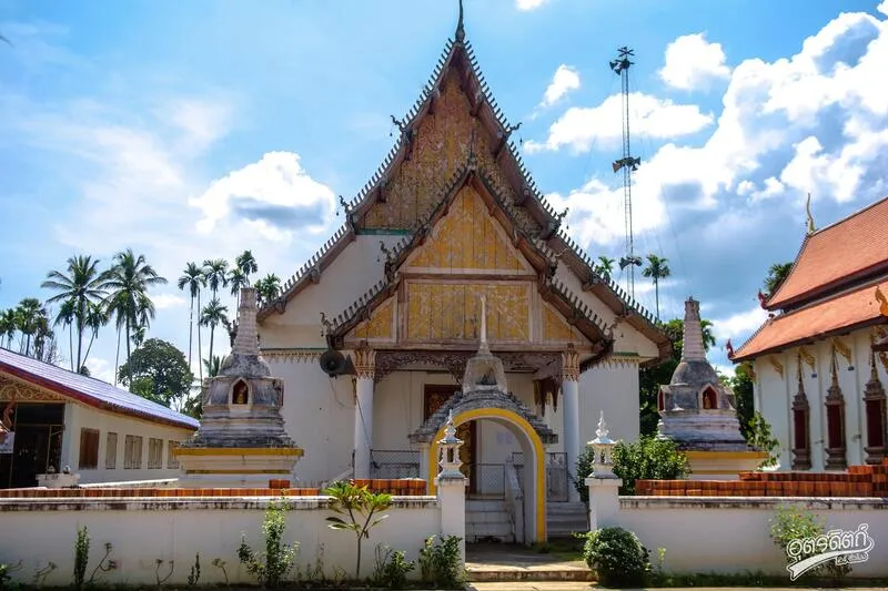
15. Wat Thong Laplae (Wat Lap Lae) is located in Fai Luang Subdistrict, Laplae District. This old community temple reflects the religious identity of Laplae and is notable for its local architecture and unusual mural details inside the religious buildings.
Highlights: Historic Laplae temple, traditional community atmosphere, local Buddhist art, unusual inverted mural imagery, and an easy connection with the old-town route.
Wat Thong Laplae forms part of the traditional settlement landscape of Fai Luang, where houses, orchards, and temples are scattered along the foothills and local roads. A visit therefore offers a more intimate view of Laplae beyond its better-known market and landmark sites.
One of the temple’s most interesting features is unusual artwork inside one of the buildings, including imagery that appears inverted. Visitors should enter respectfully and ask permission if the interior is not already open to the public.
The temple remains active in community life, with Buddhist ceremonies, merit-making, and local religious events held throughout the year. This makes it a living temple rather than simply a preserved historic monument.
Wat Thong Laplae can be combined with the Laplae city gate, Phra Si Phanommat Monument, local museums, and Mae Phun Waterfall in a full-day itinerary.
Visitors should dress modestly and avoid disturbing monks or community activities. Photography inside religious buildings should be done only where permitted.
Getting There: From Uttaradit city, travel toward Laplae District and continue into Fai Luang Subdistrict. A private car is convenient for combining the temple with other attractions around Laplae.
Map (GPS):Open Directions to Wat Thong Laplae

16. Wat Mon Prang is located in Si Phanommat Subdistrict, Laplae District. This old community temple is known for traditional northern architecture and the calm atmosphere of historic Laplae, making it a worthwhile stop for travelers interested in local culture and Buddhist art.
Highlights: Historic Lanna-style ordination hall, local Buddhist architecture, peaceful atmosphere, and a convenient location near central Laplae attractions.
Wat Mon Prang reflects the type of community temple that developed alongside local villages and traditional ways of life. Its structures are not monumental in scale, but their proportions and decorative details reveal the architectural preferences of the Laplae area.
The old ordination hall is particularly worth observing. Its roofline, building proportions, and decorative elements show influences from Lanna art together with local lower northern craftsmanship.
The temple offers a quiet setting for worship, merit-making, and photography. Morning and late afternoon provide softer light for photographing architectural details.
Wat Mon Prang can be combined with the Phra Si Phanommat Monument, Laplae city gate, Wat Thong Laplae, Wat Sao Hin, and Mae Phun Waterfall.
Visitors should remain quiet and dress respectfully, particularly during religious ceremonies and community events.
Open Days: Daily Opening Hours: 08:00 – 17:00
Getting There: From Uttaradit city, travel into Laplae District and Si Phanommat Subdistrict. The temple lies within the local community and can be combined easily with nearby historic sites.
Map (GPS):Open Directions to Wat Mon Prang

17. Wat Pha Lueat is located at Ban Pha Lueat in Pha Lueat Subdistrict, Tha Pla District. The temple is an important community religious center on the route to Sirikit Dam and Lam Nam Nan National Park, adding a cultural and spiritual dimension to a nature-focused trip through Tha Pla.
Highlights: Community temple surrounded by mountains, strong local religious traditions, peaceful atmosphere, and convenient access to Sirikit Dam and Lam Nam Nan National Park.
Wat Pha Lueat is part of a community whose history is closely connected with the Nan River, mountain landscapes, and the changes brought by the construction of Sirikit Dam.
The temple remains more than a place of worship. It also serves as a gathering place for local ceremonies, merit-making, and community activities, preserving social connections in the area.
The surrounding mountains create a peaceful atmosphere that differs from urban temples. It is therefore a pleasant stop before or after visiting the dam and nearby national park.
A visit to Wat Pha Lueat also helps travelers understand Tha Pla beyond its reservoir scenery by revealing the religious and cultural foundations of the local community.
It can be combined with Sirikit Dam, Lam Nam Nan National Park, Ban Tha Ruea, and nearby viewpoints without requiring significant backtracking.
Getting There: From Uttaradit city, follow the Uttaradit–Sirikit Dam route into Pha Lueat Subdistrict. The temple is located within Ban Pha Lueat and can easily be combined with nearby attractions.
Map (GPS):Open Directions to Wat Pha Lueat

18. Wang Din Waterfall is located near Ban Wang Kha in Wang Din Subdistrict, Mueang Uttaradit District. This peaceful natural waterfall offers forest, streams, and a quiet setting without requiring travelers to journey to the more remote border districts of the province.
Highlights: Cascading stream over natural rock, clear pools, streamside forest, ferns and moss, quiet atmosphere, and relatively easy access from Uttaradit city.
The waterfall area is shaded by trees and contains moisture-loving plants such as ferns and moss growing across rocks. This creates a cooler and more humid environment than the surrounding open countryside.
Water flows over natural rock formations and forms pools of different sizes. Some areas are suitable for sitting beside the stream or cooling your feet, while deeper pools and fast-flowing sections should be avoided.
Wang Din Waterfall works well as a half-day trip or a short nature excursion from Uttaradit city. It is suitable for travelers who want a natural environment without the physical demands of a long mountain trek.
During the rainy season, road conditions and water levels should be checked before traveling. Rocks around the stream can become slippery, and water levels may rise rapidly after heavy rain.
The waterfall can also be used as a nature stop during a wider road trip through Mueang Uttaradit and surrounding districts.
Getting There: From Uttaradit city, travel toward Wang Din Subdistrict and Ban Wang Kha before continuing along the local road to the waterfall area. Checking current road conditions with the local administrative organization before departure is recommended.
Map (GPS):Open Directions to Wang Din Waterfall

19. Wat Hua Dong is located at Ban Hua Dong in Mae Phun Subdistrict, Laplae District. This historic community temple is surrounded by hills and fruit orchards, reflecting the close relationship between Buddhist temples, village life, and agriculture that characterizes the Laplae area.
Highlights: Historic temple established in 1825, hillside setting, fruit orchard landscape, peaceful Mae Phun community atmosphere, and a route connecting naturally with Mae Phun Waterfall.
The area was originally known locally as “Wat Pa Dong” because it was surrounded by dense woodland. The name later changed to Wat Hua Dong in accordance with the local community.
The temple dates to 1825, demonstrating that the Mae Phun community has maintained an organized religious center for almost two centuries.
Its slightly elevated location gives the temple an open and peaceful atmosphere. The surrounding hills and orchards are characteristic of Mae Phun, particularly during the season for langsat, longkong, and durian.
Wat Hua Dong remains a center for community merit-making, ceremonies, and religious events. Travelers therefore see a working local temple rather than a site preserved only for tourism.
The temple can be combined with Mae Phun Waterfall, nearby orchards, and Laplae town. During fruit season, this route offers a particularly good mix of culture, nature, and local food.
Getting There: From Laplae town, travel toward Mae Phun Subdistrict and Ban Hua Dong. The temple is on the same general route as local orchards and Mae Phun Waterfall.
Map (GPS):Open Directions to Wat Hua Dong

20. Wat Sawang Arom is located at Ban Pa Daet in Phai Lom Subdistrict, Laplae District. Established in 1782, this historic community temple has served as a religious center for generations and offers a quieter alternative to the better-known temples along the Thung Yang route.
Highlights: Historic temple established in 1782, large teak pavilion, ordination hall, sermon hall, chanting hall, and the traditional community atmosphere of Phai Lom Subdistrict.
The temple was granted its official consecrated boundary in 1907, reflecting its continuing development from the early Rattanakosin period into the modern era.
One of the most notable structures is a large teak pavilion that reflects traditional woodworking and the historical use of timber in northern religious architecture. The temple also includes an ordination hall, sermon hall, chanting hall, funeral pavilion, and monks’ residences.
The appeal of Wat Sawang Arom lies less in monumental scale and more in continuity. Local residents still come here for merit-making, sermons, ceremonies, and important community events.
Visiting the temple helps travelers understand that Laplae is not only about legends, fruit, and its old town. The district also contains a network of long-established community temples that have helped shape local society for generations.
Wat Sawang Arom can be combined with Wat Phra Borommathat Thung Yang, Wat Phra Yuen Phutthabat Yukhon, and the wider Laplae area as part of a more detailed cultural itinerary.
Getting There: From Uttaradit city or Laplae town, travel toward Phai Lom Subdistrict and Ban Pa Daet. The temple is located within the local community and can be reached conveniently by private vehicle.
Map (GPS):Open Directions to Wat Sawang Arom

21. Wat Sao Hin is located in the Talat Laplae community of Si Phanommat Subdistrict, Laplae District. This historic temple dates back to 1634 during the Ayutthaya period and has remained an important Buddhist center for the Laplae community ever since. It is particularly suitable for travelers who want to explore the district’s old temples in greater depth beyond its best-known landmarks.
Highlights: Historic Ayutthaya-period temple, ordination hall, sermon hall, viharn, strong community connections, and its former name, Wat Fai Hin.
The temple was formerly known as “Wat Fai Hin,” a name connected with the local landscape and waterways of old Laplae. Over time, the name Wat Sao Hin became more widely used and is now part of the community’s historical memory.
The temple’s official consecrated boundary allowed it to perform full Buddhist monastic ceremonies, including ordinations and important Sangha rituals. This means Wat Sao Hin is significant not only for its architecture but also for its continuous religious function.
The temple complex includes several religious buildings that reflect development across different periods. Visitors should take time to observe the relationship between the temple structures and the surrounding Talat Laplae community.
Because Wat Sao Hin is located in Si Phanommat Subdistrict, it can easily be combined with the Phra Si Phanommat Monument, Wat Mon Prang, central Laplae, and local markets.
Open Days: Daily Opening Hours: 08:00 – 17:00
Getting There: From Uttaradit city, travel toward Laplae District and enter Si Phanommat Subdistrict. The temple is located in the Talat Laplae area and is easy to reach by car or motorcycle.
Map (GPS):Open Directions to Wat Sao Hin

22. Wat Na Phra That (Wat Luang Pho To) is located in Nai Mueang Subdistrict, Phichai District, beside the Nan River. This ancient temple is closely associated with old Phichai and is important for its religious history, local architecture, and the revered Luang Pho To Buddha image.
Highlights: Luang Pho To, the pair of historic Buddha images, a five-spired cruciform viharn, old Phichai heritage, and a riverside setting along the Nan River.
The temple has a long history, with local accounts tracing its importance back to around the 10th century. Its age reflects the long-standing role of Phichai as a settlement and religious center along the Nan River.
Luang Pho To is one of the temple’s most revered Buddha images and continues to attract local worshippers seeking blessings and merit. The temple also houses the pair of historic Buddha images known locally as the “two sibling Buddhas.”
One of the most visually distinctive structures is the five-spired cruciform viharn, also known as Prasat Phra Nawamarat Bophit. Its architectural form gives the temple a striking visual identity within the old town area.
Travelers interested in the story of Phraya Phichai Dap Hak should combine Wat Na Phra That with the Chao Pho Phraya Phichai Dap Hak Shrine and other historic places in Phichai District to better understand the local setting in which the warrior’s story developed.
Open Days: Daily Opening Hours: 08:00 – 17:00
Getting There: From Uttaradit city, travel south toward Phichai District and continue into Nai Mueang Subdistrict. The temple is near the Nan River and the historic center of Phichai.
Map (GPS):Open Directions to Wat Na Phra That

23. Chao Pho Phraya Phichai Dab Hak Shrine is located along the road in front of Wat Mahathat in Nai Mueang Subdistrict, Phichai District. It is an important local shrine dedicated to Phraya Phichai Dap Hak, the famous warrior who remains one of the strongest historical symbols of Uttaradit.
Highlights: Statue of Phraya Phichai Dap Hak, an important local shrine, location opposite Wat Mahathat, and an old-town atmosphere close to the Nan River.
The shrine is significant as a place of collective memory. Local residents do not view Phraya Phichai only as a historical military figure, but also as a symbol of courage, sacrifice, and loyalty whose values continue to be admired.
Its location in old Phichai helps visitors connect the story of Phraya Phichai with the actual landscape more directly than visiting the monument in Uttaradit city alone.
The shrine stands near Wat Mahathat and the Nan River, reflecting the compact character of old Phichai where temples, communities, transport routes, and the river were all closely connected.
A good historical itinerary combines the shrine with Wat Na Phra That and Poramin Bridge, creating a route that includes local heroism, Buddhist heritage, and historic transportation infrastructure.
Open Days: Daily
Getting There: The shrine is located in front of Wat Mahathat in Nai Mueang Subdistrict, Phichai District. It is easily accessible by private car and can be combined with nearby historic attractions.
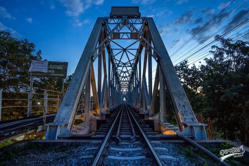
24. Poramin Bridge, also known as Ban Dara Bridge, is a railway bridge crossing the Nan River in Ban Dara Subdistrict, Phichai District. It is one of the important engineering landmarks on Thailand’s Northern Railway Line.
Highlights: Historic steel railway bridge across the Nan River, railway development during the reign of King Rama V, river scenery, and the railway-community landscape of Ban Dara.
The bridge is important as part of the expansion of Thailand’s railway network connecting Bangkok with northern towns during the period when Siam was rapidly modernizing its transportation infrastructure.
Constructing a major bridge across the Nan River represented both a significant engineering achievement and a major change in how people and goods moved through the region.
Ban Dara community has long been associated with railway transportation and Ban Dara Junction Railway Station. Visiting the bridge therefore reveals the relationship between railways, rivers, agriculture, and communities that developed along transportation corridors.
The bridge is especially interesting for railway enthusiasts, history travelers, and photographers. Visitors should remain in safe public areas and never walk onto active railway tracks.
Poramin Bridge can easily be combined with Wat Na Phra That and the Chao Pho Phraya Phichai Dab Hak Shrine in a one-day trip around Phichai.
Open Days: Daily
Getting There: The bridge is located near Ban Dara Junction Railway Station in Phichai District. View it only from safe public areas beside the river or nearby roads and do not enter the railway track area.
Map (GPS):Open Directions to Poramin Bridge

25. Wat Chedi Khiri Wihan, formerly known as Wat Pa Kaeo, is located at Ban Wat Pa in Fai Luang Subdistrict, Laplae District. This historic temple is notable for its Sri Lankan-style relic chedi, Sukhothai-style Buddha images, and traditional carved wooden details.
Highlights: Sri Lankan-style sacred chedi, Buddhist relic traditions, Sukhothai-style principal Buddha image, carved wooden doors, and the atmosphere of an old Laplae temple.
The chedi is the temple’s principal sacred structure and is traditionally believed to enshrine Buddhist relics. It therefore remains an important focus of worship for local residents and visiting devotees.
The principal Buddha image and other artistic elements reflect strong connections with Sukhothai Buddhist art, while carved wooden details reveal the craftsmanship of earlier local artisans.
The temple’s former name, Wat Pa Kaeo, reflects the area’s earlier relationship with forest and settlement patterns. Over time, the prominence of the chedi led to the name Wat Chedi Khiri Wihan becoming more widely used.
The temple can be combined with Wat Thong Laplae, Wat Mon Prang, Wat Sao Hin, and central Laplae, making it suitable for travelers who want to explore a detailed temple route.
Open Days: Daily Opening Hours: 08:00 – 17:00
Getting There: From Uttaradit city, travel into Laplae District and Fai Luang Subdistrict. The temple is located at Ban Wat Pa, approximately 10 kilometres from central Uttaradit.
Map (GPS):Open Directions to Wat Chedi Khiri Wihan

26. Kaeng Sai Ngam is located at Ban Sai Ngam in Nam Man Subdistrict, Tha Pla District. This natural stream and rocky rapid area is easy to access and suitable for families, with broad rocks, gentle water during normal conditions, and places to sit close to nature.
Highlights: Natural stream, broad rock formations, swimming areas, picnic spaces, local food and drink, and only a short walk from the parking area.
The rapids are not particularly steep and the area is relatively open, making supervision of children easier than at waterfalls with high cliffs or long trekking routes.
Water levels change with the season. Under normal conditions, the stream is suitable for relaxing and playing in designated areas, but swimming should be avoided after heavy rain because water depth and current strength can increase rapidly.
Kaeng Sai Ngam also reflects community-based tourism because food, rest areas, and visitor services are closely connected with residents of Ban Sai Ngam.
The site can be combined with Pha An Ma Viewpoint and other nature attractions in Nam Man Subdistrict, making it suitable for a one-day family or group trip.
Open Days: Daily Opening Hours: 08:00 – 17:00
Getting There: From Tha Pla District, travel into Nam Man Subdistrict and Ban Sai Ngam. From the parking area, the rapids are approximately 30 metres away on foot.
Map (GPS):Open Directions to Kaeng Sai Ngam

27. Wat Pa Sak Rerai is located at Ban Hua Hat in Khung Taphao Subdistrict, Mueang Uttaradit District. Established around 1921 through community cooperation, the temple continues to serve as a center for Buddhist practice and local activities.
Highlights: Historic community temple, peaceful atmosphere, Ban Hua Hat local life, strong temple-community relationships, and a quiet place for merit-making away from busy tourist areas.
The temple was founded through the faith and cooperation of local residents who wanted a central place for religious ceremonies, listening to sermons, merit-making, and community gatherings.
Wat Pa Sak Rerai received its official consecrated boundary on August 30, 1977, allowing the temple to conduct important monastic ceremonies fully.
The temple has a simple, peaceful atmosphere and is well suited to travelers who want to make merit or spend quiet time without the crowds and commercial activity found at larger tourist temples.
A visit also reveals a side of Mueang Uttaradit outside the main urban center and demonstrates how smaller temples continue to play an important role in local community life.
Getting There: The temple is located at Ban Hua Hat, Moo 5, Khung Taphao Subdistrict, Mueang Uttaradit District. It can be reached conveniently by private car from the city.
Map (GPS):Open Directions to Wat Pa Sak Rerai

28. Luang Pho Phet (Wat Tha Thanon) is located in Tha It Subdistrict, Mueang Uttaradit District. Luang Pho Phet is a highly revered bronze Buddha image in the Chiang Saen artistic style and is regarded as one of the province’s most important sacred images. The Buddha is enshrined at Wat Tha Thanon beside the Nan River.
Highlights: Luang Pho Phet in Chiang Saen style, historic riverside temple, former name Wat Wang Tao Mo, and a convenient location near Uttaradit Railway Station.
Luang Pho Phet, sometimes written as Luang Pho Phech, is a bronze Buddha image in the subduing Mara posture and seated in the diamond position. Its artistic form reflects Chiang Saen influence and has long attracted worshippers from Uttaradit and beyond.
Wat Tha Thanon was formerly known as “Wat Wang Tao Mo,” a name associated with the old local community and traditional pottery production before changes in roads and transportation gradually influenced the present temple name.
The temple’s riverside setting also reflects the transition of Uttaradit from an era when river transport dominated commerce to later periods when roads and railways became increasingly important.
The temple can easily be combined with the Uttaradit Provincial Cultural Hall, Phraya Phichai Dap Hak Monument, and other attractions in Tha It Subdistrict.
Open Days: Daily
Getting There: Wat Tha Thanon is located in Tha It Subdistrict, Mueang Uttaradit District, close to the Nan River and Uttaradit Railway Station. Visitors wishing to enter specific interior areas should contact the temple when necessary.

29. Uttaradit Provincial Cultural Hall is located on Paet Wa Road in Tha It Subdistrict, Mueang Uttaradit District. It is a learning center that brings together the province’s history, antiquities, traditional knowledge, local lifestyles, and cultural heritage in one place.
Highlights: Local antiquities, carved wooden yanamat palanquin, historic household objects, traditional knowledge, Nan River community history, and the development of Uttaradit town.
One of the important artifacts is a carved wooden “yanamat” palanquin with three openwork tiers, reflecting the craftsmanship of the late Ayutthaya period and representing an important example of traditional woodcarving.
The collections help explain everyday life across different periods, including religion, society, trade, tools, domestic objects, and Uttaradit’s connections with other towns in northern and central Thailand.
For travelers planning a deeper exploration of the province, the Cultural Hall is a useful starting point because it provides context for Laplae, historic temples, old Phichai, and communities along the Nan River.
It is suitable for students, families, researchers, and travelers interested in history. Opening days should be checked carefully because access is more limited than at outdoor attractions.
Open Days: Sunday Opening Hours: 09:00 – 12:00
Getting There: The Cultural Hall is located on Paet Wa Road in Tha It Subdistrict, Mueang Uttaradit District, near the city center and government area. It can be reached conveniently by car or local transport.

30. Wat Yai Tha Sao is located on Samran Ruen Road in Tha Sao Subdistrict, Mueang Uttaradit District. This historic temple is notable for traditional architecture, carved wooden elements, ancient objects, and its connection with Tha Sao community, which once developed along important transportation and trading routes.
Highlights: Historic viharn, carved wooden doors, old scripture library, carved wooden yanamat palanquin, and the history of Tha Sao community near the railway.
The temple is believed to date to the late Ayutthaya period, when Tha Sao community was expanding through settlement, trade, and transport connections.
The old viharn and scripture library reflect the temple’s role in both religion and education. Traditionally, scripture libraries were used to preserve Buddhist manuscripts and religious texts.
Carved wooden doors and the historic yanamat demonstrate the high level of woodworking skill practiced by artisans in old Uttaradit and are especially valuable for visitors interested in local decorative arts.
The temple’s location near Tha Sao Railway Station also makes it possible to connect the history of the community from the river-and-road era to the later expansion of railway transportation.
Wat Yai Tha Sao can be combined with Wat Tha Thanon, the Uttaradit Provincial Cultural Hall, and the Phraya Phichai Dap Hak Monument in a city itinerary.
Open Days: Daily
Getting There: The temple is located on Samran Ruen Road in Tha Sao Subdistrict, Mueang Uttaradit District, close to Tha Sao Railway Station. Visitors wishing to see museum areas or historic objects inside should contact the temple in advance.
Map (GPS):Open Directions to Wat Yai Tha Sao

31. Wat Thamma Thipatai is located on Samran Ruen Road in Tha It Subdistrict, Mueang Uttaradit District. This historic city temple is important for religion, local history, and traditional craftsmanship, especially its ancient carved wooden doors preserved inside the Thamma Sabha building.
Highlights: Late Ayutthaya-period carved wooden doors, kanok scroll motifs, phum khao bin patterns, the Thamma Sabha building, and the history of an old temple in central Uttaradit.
Wat Thamma Thipatai was originally known as “Wat Ton Makham,” meaning Tamarind Tree Temple, because many large tamarind trees once grew around the temple grounds. As the temple became increasingly important to the urban community, its name was changed to Wat Thamma Thipatai, conveying the idea of placing Dhamma above all else.
One of the temple’s most valuable objects is a pair of large carved wooden doors originally from the viharn of Wat Phra Fang Sawangkhaburi Muni Nat. Each door is approximately 2.2 metres wide, 5.3 metres high, and around 16 centimetres thick. The surfaces are elaborately carved with kanok scrolls and phum khao bin motifs, demonstrating the high level of craftsmanship associated with the late Ayutthaya period.
Viewing these doors helps connect Wat Thamma Thipatai with Wat Phra Fang and the history of Sawangkhaburi. The temple therefore provides useful context for understanding how important religious objects and artistic traditions moved between major Buddhist sites in Uttaradit.
The temple is conveniently located in central Uttaradit near major roads, the railway area, and commercial districts. It can easily be combined with Wat Tha Thanon, the Uttaradit Provincial Cultural Hall, and the Phraya Phichai Dap Hak Monument in a half-day city itinerary.
Open Days: Daily
Getting There: The temple is located at 7 Samran Ruen Road, Tha It Subdistrict, Mueang Uttaradit District, near the intersection of In Chai Mi Road and Samran Ruen Road. Visitors wishing to see the carved wooden doors inside the Thamma Sabha building should contact the temple when necessary.
Map (GPS):Open Directions to Wat Thamma Thipatai

32. Mae Choei Waterfall is located at Ban Mon Hua Fai in Ban Dan Na Kham Subdistrict, Mueang Uttaradit District. It is a natural waterfall suitable for travelers who want to experience forest, streams, and a quiet environment without traveling far from the province’s main routes.
Highlights: Forest stream, natural rock formations, clear water, peaceful surroundings, and access approximately 10 kilometres from the Asian Highway.
Mae Choei Waterfall consists of a stream flowing through rocks and natural terraces under the shade of large trees and local vegetation. The surrounding forest creates a cool and humid environment, particularly during the rainy season.
The charm of the waterfall lies less in great height and more in the simplicity of the setting. It is a good place to relax, take photographs, listen to running water, and enjoy nature without a demanding trek.
Water levels vary according to the season. The rainy season and the period immediately after it generally bring stronger water flow and greener forest scenery, although slippery rocks and rapidly changing water conditions require additional caution.
Mae Choei Waterfall works well as a half-day trip from Uttaradit city or as a nature stop when traveling toward mountainous areas north of the city.
Open Days: Daily Opening Hours: 08:00 – 17:00
Getting There: From the Asian Highway, turn toward Ban Dan Na Kham Subdistrict and continue approximately 10 kilometres toward Ban Mon Hua Fai. A private car or motorcycle is the most convenient option.
Map (GPS):Open Directions to Mae Choei Waterfall

33. Tham Chan is located near Ban Nam Mi Yai in Phak Khwang Subdistrict, Thong Saen Khan District. This large limestone cave lies within the Tham Chan Forest Park area and is suitable for travelers interested in geology, cave exploration, and quieter natural environments.
Highlights: Large cave entrance, spacious chambers, stalactites and stalagmites, several surrounding limestone caves, and natural light entering through openings in the rock.
Tham Chan is the largest cave in the local cave group. Its broad entrance and large interior chambers create an immediate sense of scale, while the temperature becomes noticeably cooler after entering the cave.
Inside are limestone formations, stalactites, stalagmites, and textured rock surfaces created over long geological periods. In some areas, daylight enters through openings above, producing dramatic contrasts between light and shadow.
Several other caves are scattered around the area. Deeper exploration should be undertaken with a local guide or knowledgeable person, and visitors should avoid separating from their group because some sections are dark, slippery, and contain branching passages.
Tham Chan can be combined with Nam Phi Iron Wells, creating a Thong Saen Khan itinerary that includes geology, natural landscapes, local history, and traditional metallurgy in one day.
Getting There: Tham Chan is located near Ban Nam Mi Yai in Phak Khwang Subdistrict, Thong Saen Khan District. Morning to early afternoon is the most practical time to visit, and travelers should ask local residents or responsible authorities about current access conditions before exploring the cave.
Map (GPS):Open Directions to Tham Chan

34. Phu Thung Laeng is a mountain attraction in Ban Khok District near Muang Chet Ton Subdistrict and the Thai–Lao border. Its appeal lies in open highland grassland, expansive mountain views, cool weather, and scenery that differs from the dense forest landscapes found elsewhere in northern Thailand.
Highlights: Highland grassland, mountain views along the Thai–Lao border, broad panoramas, cool weather, and a scenic route that can be combined with Phu Du.
Phu Thung Laeng consists of relatively open terrain along elevated mountain ridges. From higher areas, visitors can see overlapping mountain ranges, forest, and communities stretching across the surrounding landscape.
The cool season is particularly suitable for sightseeing and enjoying lower temperatures, while the period after the rainy season brings greener scenery and changing patterns of mist and cloud.
Photographers should consider visiting in the morning or late afternoon, when softer light adds more depth to the mountain ridges than strong midday sunlight.
Roads in Ban Khok District pass through mountainous border terrain. Travelers should allow sufficient driving time, keep the fuel tank adequately filled, and make sure their vehicle is in good condition before continuing toward Phu Du or other border attractions.
Open Days: Daily
Getting There: From Ban Khok District, travel toward Muang Chet Ton Subdistrict and the Thai–Lao border route. A private vehicle is the most practical way to explore this area.
Map (GPS):Open Directions to Phu Thung Laeng

35. Khao Phlueng Viewpoint is located near Ban Hai Ha in Ban Dan Na Kham Subdistrict, Mueang Uttaradit District, along the important road connecting Uttaradit and Phrae. The mountain area serves as a scenic rest point along one of lower northern Thailand’s classic mountain driving routes.
Highlights: Mountain views along the Uttaradit–Phrae route, roadside rest opportunities, cooler weather during the cool season, and scenery along the mountain corridor linking the 2 provinces.
Khao Phlueng has long been familiar to travelers driving between Uttaradit and Phrae. The road crosses elevated terrain with a series of curves, offering continuous views of mountains and forest along the journey.
Temperatures are generally cooler than in the lowlands during the cool season, and mist can occur in the morning. Drivers should reduce speed and exercise caution when visibility is limited.
Designated roadside areas are suitable for a short break, mountain photography, and stretching before continuing toward Phrae or returning to Uttaradit.
Khao Phlueng is especially suitable for road-trip travelers because the attraction is primarily about experiencing the mountain route itself rather than visiting a developed tourist complex.
Open Days: Daily
Getting There: Khao Phlueng lies on the Uttaradit–Phrae road near Ban Hai Ha in Ban Dan Na Kham Subdistrict. Stop only in designated safe areas and avoid parking on narrow road shoulders.

36. Phu Du Permanent Border Crossing is located at Ban Phu Du in Muang Chet Ton Subdistrict, Ban Khok District, along the Thai–Lao border. The area is important for cross-border transportation, trade, and links between Uttaradit and Xayaboury Province in Laos.
Highlights: Thai–Lao border atmosphere, cross-border trade, local products, scenic mountain roads, and proximity to Phu Thung Laeng and other attractions in Ban Khok District.
Phu Du is geographically important because it occupies a natural passage through the border mountain ranges. This location has long supported communication and trade between communities on both sides of the Thai–Lao border.
For travelers, Phu Du reveals another dimension of Uttaradit as a border province. The province is not only associated with temples, waterfalls, and Laplae, but also with regional trade routes and cultural connections extending into neighboring Laos.
Depending on current conditions, shops and cross-border products may be found around the area. However, immigration rules, permitted travel documents, operating arrangements, and border-crossing procedures can change according to government announcements.
Travelers intending to cross into Laos should not rely on general tourism information as confirmation that crossing is permitted. Current border status and entry requirements should always be checked directly with immigration or responsible provincial authorities before traveling.
Open Days: Daily Opening Hours: 08:00 – 18:00
Getting There: From Ban Khok District, continue toward Muang Chet Ton Subdistrict and Ban Phu Du. The road crosses mountainous terrain and is far from central Uttaradit, so travelers should fuel their vehicle and check its condition before departure.

37. Khlong Tron Reservoir is located in Nam Khrai Subdistrict, Nam Pat District. The reservoir is an important irrigation project that stores water for agriculture and local communities, while its broad water surface and surrounding mountains also create an attractive landscape for sightseeing and relaxation.
Highlights: Earth-fill dam with clay core, mountain reservoir scenery, peaceful viewpoints, sunset views, and easy connections with Khlong Tron National Park.
The Khlong Tron Reservoir project was developed between 1994 and 1997 to reduce dry-season water shortages and improve water management during the rainy season.
The dam is an earth-fill structure with a clay core. Its crest is approximately 9 metres wide, around 220 metres long, and about 48 metres high. The catchment area above the reservoir covers approximately 265 square kilometres.
Although the reservoir’s main role is water management, the broad lake and surrounding mountains create a quiet atmosphere that is well suited to photography, scenic breaks, and watching changing light in the morning or evening.
Khlong Tron Reservoir can be combined with Ton Sak Yai Forest Park and Khlong Tron National Park, making the Nam Pat area suitable for a full-day nature itinerary.
Open Days: Daily
Getting There: The reservoir is located in Nam Khrai Subdistrict, Nam Pat District. From Uttaradit city, travel through Tha Pla toward Nam Pat. A private car is the most convenient option.
Map (GPS):Open Directions to Khlong Tron Reservoir

38. Khlong Tron National Park is a large protected forest area in Uttaradit containing mountains, watershed forest, streams, waterfalls, caves, and cliffs. It is especially suitable for travelers who want a more serious nature experience than an ordinary roadside attraction.
Highlights: Khlong Tron Waterfall, Huai Khom Waterfall, Phu Miang Cliff, Tham Chan, Tham Chedi, Tham Suea Dao, Tham Pha Tang, watershed forest, and trekking routes.
The national park covers approximately 324,240 rai, or about 518.8 square kilometres. Its rugged mountain terrain contains important watershed forests, with Khlong Tron forming one of the principal natural drainage systems.
Khlong Tron National Park was officially established on December 4, 2003. The protected area plays an important role in conserving Uttaradit’s forest and watershed ecosystems.
Hikers can choose routes according to time and difficulty, but more remote waterfalls and caves should be visited only after checking with park officials because trail conditions and access can change seasonally.
The park is suitable for forest study, birdwatching, photography, camping, and experiencing quiet natural surroundings. During the rainy season, the forest becomes especially lush and waterfalls are more impressive, although trails can also become slippery and streams more hazardous.
Open Days: Daily Opening Hours: 07:00 – 18:00
Getting There: Access the park from the Nam Pat and Nam Khrai areas. A private vehicle is recommended, and visitors should ask park staff about the specific destination or trail they plan to visit before setting out.

39. Bueng Thap Kradan Public Park is located in Moo 10, Wang Daeng Subdistrict, Tron District. This community recreational area features a broad pond, exercise areas, pavilions, and open public space, making it suitable for families, older travelers, and anyone looking for a relaxed stop during a road trip.
Highlights: Large community pond, waterside pavilion, exercise area, local fishing culture, seasonal communal fishing activities, and recreational space.
Bueng Thap Kradan is used by local residents for relaxation, walking, exercise, and community activities. The atmosphere is therefore distinctly local and far less commercial than major tourist attractions.
Pavilions, landscaped spaces, and walking areas around the pond make it particularly pleasant in the morning and late afternoon when temperatures are lower.
The park also reflects the community’s relationship with freshwater resources. Traditional group fishing activities may be organized at certain times of year, illustrating how local people collectively manage the pond and its fish resources.
For travelers passing through Tron District, the park is a practical rest stop before continuing toward Phichai, central Uttaradit, or attractions farther north.
Open Days: Daily Opening Hours: 08:00 – 17:00
Getting There: The park is located in Moo 10, Wang Daeng Subdistrict, Tron District, opposite the Uttaradit Aquatic Genetics Research and Development Center. It is easily accessible by private car.

40. Wat Wang Moo is located at Ban Wang Moo in Hat Kruat Subdistrict, Mueang Uttaradit District. This ancient temple has a history extending back to the Sukhothai period and is associated with a local legend about a “golden wild boar,” which is believed to be connected with the names of both the community and the temple.
Highlights: Ancient temple more than 800 years old, local golden-boar legend, historic religious art, traditional Nan River community life, and folklore connected with river trade.
The temple is believed to have been established around 1157 and to have received its official consecrated boundary around 1189, making it one of the older temples in the Mueang Uttaradit area.
One of its most distinctive traditions is the story of a wild boar with a golden body appearing near the Nan River landing. The legend was passed down through generations and became associated with the name “Wang Moo.”
The story also reflects the community’s relationship with the Nan River, which in earlier periods served as an important route for trade and transportation. Merchants and residents relied heavily on boats for movement and exchange.
The temple contains religious architecture and artistic elements reflecting the age of the settlement, while continuing to function as an active community temple for ceremonies and merit-making.
Wat Wang Moo is particularly suitable for travelers interested in local history, folk legends, and temples outside the main tourist routes. It adds another dimension to Uttaradit as an old province whose communities developed along the Nan River.
Getting There: The temple is located at Ban Wang Moo in Hat Kruat Subdistrict, Mueang Uttaradit District. It is easily reached by private car from the city and is best visited during daytime.
Map (GPS):Open Directions to Wat Wang Moo
| Travel Category | Recommended Attractions |
| Nature And Waterfalls | 1. Phu Soi Dao National Park 2. Mae Phun Waterfall 3. Lam Nam Nan National Park 4. Wang Din Waterfall 5. Kaeng Sai Ngam 6. Mae Choei Waterfall 7. Tham Chan 8. Khlong Tron National Park |
| Mountains And Viewpoints | 1. Phu Soi Dao National Park 2. Pha An Ma Viewpoint 3. Phu Thung Laeng 4. Khao Phlueng Viewpoint 5. Khlong Tron National Park |
| Dams, Reservoirs And Waterfront Communities | 1. Sirikit Dam 2. Ban Tha Ruea 3. Ban Huai Ta 4. Lam Nam Nan National Park 5. Khlong Tron Reservoir |
| History And Local Heroes | 1. Phraya Phichai Dap Hak Monument 2. Wat Phra Fang Sawangkhaburi Muni Nat 3. Wat Na Phra That (Wat Luang Pho To) 4. Chao Pho Phraya Phichai Dab Hak Shrine 5. Poramin Bridge 6. Uttaradit Provincial Cultural Hall |
| Temples And Sacred Places | 1. Wat Phra Borommathat Thung Yang 2. Wat Phra Yuen Phutthabat Yukhon 3. Wat Phra Fang Sawangkhaburi Muni Nat 4. Wat Thong Laplae (Wat Lap Lae) 5. Wat Mon Prang 6. Wat Pha Lueat 7. Wat Hua Dong 8. Wat Sawang Arom 9. Wat Sao Hin 10. Wat Na Phra That (Wat Luang Pho To) 11. Wat Chedi Khiri Wihan 12. Wat Pa Sak Rerai 13. Luang Pho Phet (Wat Tha Thanon) 14. Wat Yai Tha Sao 15. Wat Thamma Thipatai 16. Wat Wang Moo |
| Laplae And Local Culture | 1. Phra Si Phanommat Monument 2. Mae Phun Waterfall 3. Wat Thong Laplae 4. Wat Mon Prang 5. Wat Hua Dong 6. Wat Sao Hin 7. Wat Chedi Khiri Wihan 8. Wat Phra Borommathat Thung Yang 9. Wat Phra Yuen Phutthabat Yukhon |
| Local Wisdom And Learning | 1. Nam Phi Iron Wells 2. Uttaradit Provincial Cultural Hall 3. Ton Sak Yai Forest Park 4. Wat Thamma Thipatai 5. Wat Yai Tha Sao |
| Thai–Lao Border Area | 1. Phu Du Permanent Border Crossing 2. Phu Thung Laeng 3. Phu Soi Dao National Park |
| Best For Families | 1. Sirikit Dam 2. Phraya Phichai Dap Hak Monument 3. Mae Phun Waterfall 4. Ton Sak Yai Forest Park 5. Nam Phi Iron Wells 6. Ban Tha Ruea 7. Kaeng Sai Ngam 8. Bueng Thap Kradan Public Park |
| Best For Photography | 1. Phu Soi Dao National Park 2. Sirikit Dam 3. Mae Phun Waterfall 4. Ban Huai Ta 5. Pha An Ma Viewpoint 6. Poramin Bridge 7. Phu Thung Laeng 8. Khlong Tron Reservoir |
| Best For Adventure | 1. Phu Soi Dao National Park 2. Tham Chan 3. Khlong Tron National Park 4. Pha An Ma Viewpoint 5. Phu Thung Laeng |
| Uttaradit City Zone | Phraya Phichai Dap Hak Monument, Wat Phra Fang Sawangkhaburi Muni Nat, Wat Pa Sak Rerai, Luang Pho Phet at Wat Tha Thanon, Uttaradit Provincial Cultural Hall, Wat Yai Tha Sao, Wat Thamma Thipatai, Mae Choei Waterfall, Khao Phlueng Viewpoint and Wat Wang Moo |
| Laplae–Thung Yang Zone | Mae Phun Waterfall, Wat Phra Borommathat Thung Yang, Phra Si Phanommat Monument, Wat Phra Yuen Phutthabat Yukhon, Wat Thong Laplae, Wat Mon Prang, Wat Hua Dong, Wat Sawang Arom, Wat Sao Hin and Wat Chedi Khiri Wihan |
| Tha Pla–Nam Pat Zone | Sirikit Dam, Ton Sak Yai Forest Park, Lam Nam Nan National Park, Ban Tha Ruea, Ban Huai Ta, Pha An Ma Viewpoint, Wat Pha Lueat, Kaeng Sai Ngam, Khlong Tron Reservoir and Khlong Tron National Park |
| Thong Saen Khan Zone | Nam Phi Iron Wells and Tham Chan |
| Phichai–Tron Zone | Wat Na Phra That (Wat Luang Pho To), Chao Pho Phraya Phichai Dab Hak Shrine, Poramin Bridge and Bueng Thap Kradan Public Park |
| Ban Khok–Border Zone | Phu Thung Laeng, Phu Du Permanent Border Crossing and Phu Soi Dao National Park |
| 1-Day Uttaradit City Itinerary | Phraya Phichai Dap Hak Monument → Uttaradit Provincial Cultural Hall → Wat Thamma Thipatai → Luang Pho Phet at Wat Tha Thanon → Wat Yai Tha Sao |
| 1-Day Laplae Itinerary | Wat Phra Borommathat Thung Yang → Wat Phra Yuen Phutthabat Yukhon → Phra Si Phanommat Monument → Wat Mon Prang → Wat Thong Laplae → Mae Phun Waterfall |
| 1-Day Tha Pla–Nam Pat Itinerary | Sirikit Dam → Wat Pha Lueat → Lam Nam Nan National Park → Ton Sak Yai Forest Park → Khlong Tron Reservoir |
| 1-Day Phichai Itinerary | Wat Na Phra That → Chao Pho Phraya Phichai Dab Hak Shrine → Poramin Bridge → Bueng Thap Kradan Public Park |
| Uttaradit 2 Days 1 Night | Day 1: Uttaradit city → Laplae → Mae Phun Waterfall Day 2: Sirikit Dam → Lam Nam Nan National Park → Ton Sak Yai Forest Park |
| Uttaradit 3 Days 2 Nights | Day 1: Uttaradit city and Laplae Day 2: Sirikit Dam–Tha Pla–Nam Pat Day 3: Nam Phi Iron Wells → Tham Chan → Phichai |
| Phu Soi Dao Trip | Allow at least 2 days and 1 night if you plan to trek to the Three-Needle Pine Plateau. The trip requires significant travel time, preparation, an approximately 6.5-kilometre hike, and an overnight stay in the highland area according to current national park regulations. |
| Visiting All 40 Attractions | Allow approximately 6–8 days and divide the trip into Uttaradit city, Laplae–Thung Yang, Phichai–Tron, Thong Saen Khan, Tha Pla–Nam Pat, and Ban Khok–Phu Soi Dao zones to reduce backtracking and driving time. |
| Best Time To Visit | November to February is generally the most comfortable period for sightseeing and mountain travel. Fruit season is especially good for Laplae, while the late rainy season is suitable for waterfalls and lush scenery. Travelers visiting Phu Soi Dao should always confirm current trail-opening periods and national park announcements. |
| Getting Around Uttaradit | A private car or rental car is the most convenient option because attractions are spread across many districts. This is especially important for Nam Pat, Ban Khok, Thong Saen Khan and Phu Soi Dao. Check the vehicle carefully, keep enough fuel, and allow extra time on mountain roads. |
| Local Products And Souvenirs | Long Laplae durian, Lin Laplae durian, langsat, longkong, seasonal fruit, Nam Phi iron products, Laplae local food and community products from Uttaradit. |
| Important Travel Advice | Trekking routes, caves, waterfalls, national parks, boat activities and border areas may change access conditions according to weather, season, water level and government announcements. Always check current information before traveling. |
Frequently Asked Questions (FAQ)
Q: What are the best places to visit in Uttaradit for a first-time traveler?
A: First-time visitors should consider the Phraya Phichai Dap Hak Monument, Laplae, Mae Phun Waterfall, Sirikit Dam, Wat Phra Borommathat Thung Yang, Wat Phra Yuen Phutthabat Yukhon, Nam Phi Iron Wells and Phu Soi Dao National Park if enough time is available.
Q: How should I plan a 1-day trip to Uttaradit?
A: Choose only 1 geographic zone. For Uttaradit city, visit the Phraya Phichai Dap Hak Monument, Uttaradit Provincial Cultural Hall, Wat Thamma Thipatai and Wat Tha Thanon. For Laplae, combine Wat Phra Borommathat Thung Yang, Wat Phra Yuen Phutthabat Yukhon, central Laplae and Mae Phun Waterfall.
Q: Is 2 days and 1 night enough for Uttaradit?
A: Yes. A 2-day trip is enough for several major attractions such as Uttaradit city, Laplae, Sirikit Dam and part of the Nam Pat area. Phu Soi Dao should generally be treated as a separate trip with additional time.
Q: When is the best time to visit Phu Soi Dao?
A: The rainy season is famous for seasonal wildflowers, especially around August and September, while the cool season is better for colder weather, mist and pine forest scenery. Always check current national park announcements before traveling.
Q: Is the trek to Phu Soi Dao difficult?
A: The route to the Three-Needle Pine Plateau is approximately 6.5 kilometres and generally takes around 4–6 hours. Several sections are steep, so hikers should prepare physically and bring suitable trekking shoes, water, rain protection and appropriate gear.
Q: What can I see in Laplae?
A: Laplae is known for the Phra Si Phanommat Monument, historic temples, Mae Phun Waterfall, Wat Phra Borommathat Thung Yang, Wat Phra Yuen Phutthabat Yukhon, fruit orchards and local food, especially during the durian and langsat season.
Q: What are the most famous souvenirs from Uttaradit?
A: Popular local products include Long Laplae durian, Lin Laplae durian, langsat, longkong, other seasonal fruit, Nam Phi iron products and local food from Laplae communities.
Q: Why are the Nam Phi Iron Wells important?
A: Nam Phi Iron Wells preserve the history of local iron ore, traditional smelting, weapon-making, metalworking knowledge and cultural beliefs surrounding Nam Phi iron, making the site one of Uttaradit’s most distinctive cultural attractions.
Q: Which Uttaradit attractions are suitable for families?
A: Sirikit Dam, Mae Phun Waterfall, Ton Sak Yai Forest Park, Nam Phi Iron Wells, Kaeng Sai Ngam, Ban Tha Ruea, Bueng Thap Kradan Public Park and attractions around Uttaradit city are relatively easy to visit and do not require demanding trekking.
Q: Which places are best for travelers interested in history?
A: Recommended historical attractions include the Phraya Phichai Dap Hak Monument, Wat Phra Fang Sawangkhaburi Muni Nat, Uttaradit Provincial Cultural Hall, Wat Yai Tha Sao, Wat Thamma Thipatai, Wat Na Phra That, Chao Pho Phraya Phichai Dab Hak Shrine and Poramin Bridge.
Q: Can Sirikit Dam be visited on a day trip?
A: Yes. Sirikit Dam can be visited as a day trip from Uttaradit city. Travelers who start early may also combine it with Lam Nam Nan National Park, Ton Sak Yai Forest Park or Khlong Tron Reservoir.
Q: Does Uttaradit have attractions near the Thai–Lao border?
A: Yes. Ban Khok District includes Phu Du Permanent Border Crossing and Phu Thung Laeng, which offer mountain scenery and insight into the Thai–Lao border area. Border-crossing conditions can change, so official regulations should always be checked before travel.
Q: What is the best month to visit Uttaradit?
A: November to February is generally the most comfortable period because temperatures are cooler. Fruit season is ideal for Laplae, while the late rainy season is good for waterfalls and lush landscapes. Phu Soi Dao should be planned according to seasonal park access.
Q: Do I need a private car to travel around Uttaradit?
A: A private car is not essential for central Uttaradit, but it is highly recommended for Laplae, Tha Pla, Nam Pat, Thong Saen Khan, Ban Khok and Phu Soi Dao because attractions are widely dispersed and public transportation is limited.
Q: How many days are needed to visit all 40 attractions?
A: Around 6–8 days is recommended. Divide the journey into Uttaradit city, Laplae–Thung Yang, Phichai–Tron, Thong Saen Khan, Tha Pla–Nam Pat and Ban Khok–Phu Soi Dao zones. Additional time is useful if trekking and camping at Phu Soi Dao.
 Category: ●Travel Articles, Recipes
 Group: ●Travel Review, Food Review
Last Update : 2 WeekAgo
 Last Update : 2 WeekAgo
Recommend

 Art, Culture and Heritage
 Historical Sites and Monuments(2)
 Landmarks and Memorials(8)
 Art, Craft Centres, Tradition(3)
 Museums(1)
 Historic Homes and Cities(1)
 Places of Worship
 Temple(42)
 Other Sacred Sites(6)
 Suburban Living
 Village, Community(4)
 Nature and Wildlife
 National Parks and Marine Reserves(5)
 Mountain (Doi)(3)
 Dam, Reservoir, Lake(3)
 Waterfalls(11)
 Caves(3)
 River, Canal(3)
 Other natural attractions(3)
 Entertainment and Agricultural
 Farms, Parks and Ecotourism(1)
Travel Review, Food Review(1)


