lovethailand home >North Travel Attractions >Uttaradit Travel Attractions >Nam Pad >Huai Mun > Phu Soi Dao National Park
TL;DR: Phu Soi Dao National Park is located at Huai Mun Subdistrict, Nam Pat District, Uttaradit Province, with connected areas in Chat Trakan District, Phitsanulok Province, open Daily, hours Contact The Park Before Traveling.

Phu Soi Dao National Park

Open Days: Daily
Opening Hours: Contact The Park Before Traveling
Phu Soi Dao National Park is one of the most famous mountain and trekking destinations in northern Thailand. The park covers areas of Nam Pat and Ban Khok districts in Uttaradit Province, as well as Chat Trakan District in Phitsanulok Province. It is widely known for Phu Soi Dao peak, which rises approximately 2,102 metres above sea level, the Three-Needle Pine Plateau, Phu Soi Dao Waterfall, Sai Thip Waterfall, seasonal wildflower fields, the Thai-Lao border marker, and one of Thailand’s most memorable highland trekking routes.
Phu Soi Dao is more than a scenic mountain. It is a fertile watershed forest with a rich natural landscape that changes dramatically by season. The park includes mountain forest, pine forest, moist forest, waterfalls, grassland, and highland flower fields. During the rainy season, the plateau becomes famous for wildflowers such as Murdannia gigantea, yellow wildflowers, and fragrant grasses. During the cool season, travelers come for cold mountain air, red maple leaves, and camping among pine trees. This seasonal variety is one of the main reasons Phu Soi Dao remains a highly desired destination for Thai hikers and nature travelers.
The area was originally established as Phu Soi Dao Forest Park on November 13, 1990, covering about 48,962.5 rai in Nam Pat District of Uttaradit and Chat Trakan District of Phitsanulok. Later, in 1994, the National Park Division of the Royal Forest Department surveyed additional forest areas in Ban Khok and Nam Pat districts of Uttaradit and Chat Trakan District of Phitsanulok. The expanded area covered approximately 125,110 rai, or 199 square kilometres, to support the establishment of Phu Soi Dao National Park. This history reflects the importance of the area as a protected forest, watershed, and nature tourism site.
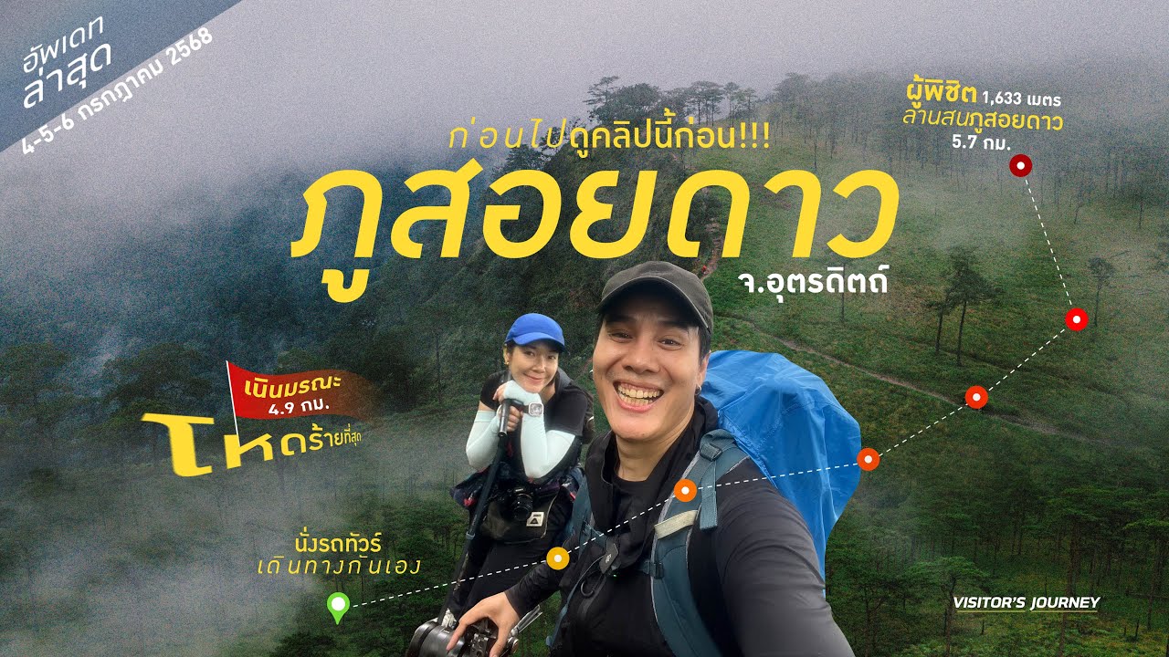
The highest summit of Phu Soi Dao reaches about 2,102 metres above sea level, making it one of the highest peaks in Thailand. Because of this elevation, the weather on the mountain is much cooler than the lowland areas. Travelers who plan to trek to the high plateau must prepare properly for changing weather, especially rain, wind, cold temperatures, and muddy trails. Although the trekking distance is about 6.5 kilometres, several sections are steep and physically demanding, so visitors should be in suitable physical condition before attempting the route.
The Three-Needle Pine Plateau is the most iconic area of Phu Soi Dao. Located approximately 1,633 metres above sea level, the plateau covers more than 1,000 rai and features a combination of pine forest, grassland, low hills, and wide open spaces. It is the main camping area for trekkers and the best place to experience the atmosphere of Phu Soi Dao. The view of pine trees standing across highland grassland, with mountains in the distance, creates a landscape that is very different from most lowland attractions in Thailand.
The trek to the Three-Needle Pine Plateau begins near Phu Soi Dao Waterfall along Highway 1268. The trail is about 6.5 kilometres long and usually takes 4–6 hours. It includes forest paths, steep slopes, muddy sections during the rainy season, and well-known uphill sections such as Noen Song Yat, Noen Prap Sian, and Noen Morana. The route is rewarding but physically demanding. Good shoes, light packing, rain protection, drinking water, and careful pacing are essential. Porter services are usually available according to park arrangements during the open trekking season.
Phu Soi Dao Waterfall is one of the easiest attractions to reach within the park because it is located near the park office area and Highway 1268. The waterfall has 5 tiers, each with a poetic Thai name: Phu Soi Dao, Sakao Duean, Muean Fan, Kannika, and Suphaphon. Water flows throughout the year, and Lum Phop Waterfall is also located nearby. Phu Soi Dao Waterfall is suitable for visitors who do not plan to trek to the plateau but still want to experience the forest, waterfall, and mountain atmosphere of the park.
Sai Thip Waterfall is a smaller waterfall with 7 tiers, each about 5–10 metres high. The forest around the waterfall is very moist, allowing green moss to grow over rocks along the stream. This gives the area a fresh, shaded, and photogenic character. Sai Thip Waterfall adds another dimension to the Phu Soi Dao experience because it offers a softer and more intimate forest atmosphere compared with the open pine plateau.
The wildflower fields in the pine forest are the most famous seasonal highlight of Phu Soi Dao. From August to September each year, ground flowers bloom densely across the plateau, including Murdannia gigantea, yellow wildflowers, and fragrant grass flowers. The sight of purple and yellow blooms among pine trees and grassland makes the rainy season one of the most beautiful times to visit, even though the trail is wetter and more difficult. For many hikers, this is the classic Phu Soi Dao experience.
In the cool season, the park presents a different beauty. Visitors can see silver button flowers, Paphiopedilum orchids, and red maple leaves when seasonal conditions are suitable. The colder weather, morning mist, and pine forest atmosphere make winter a popular time for camping. Travelers who visit during this season should bring warm clothing, wind protection, and appropriate sleeping gear because temperatures on the plateau can feel much colder than expected.
The Thai-Lao border marker is another meaningful point in the park. It marks the boundary between Thailand and Laos and is connected to the historical context of the Ban Rom Klao conflict. For many visitors, this marker adds geographical and historical significance to the journey, showing that Phu Soi Dao is not only a natural destination but also a borderland landscape with important historical memory.
Travelers must pay close attention to seasonal park announcements. The Three-Needle Pine Plateau is normally closed for ecological recovery during certain periods each year. In 2026, the plateau trekking area is closed from February 1 to June 30. This closure allows the highland ecosystem, wildflower fields, and camping areas to recover from tourism impact. During the closure period, visitors should focus only on areas that the park allows, such as the lower waterfall zone and visitor service areas, and should always contact the park before traveling.
Visitors who plan to trek to the plateau must register according to park procedures, confirm accommodation or camping arrangements, and prepare essential equipment. Recommended items include trekking shoes, rainwear, warm clothing, a headlamp or flashlight, waterproof bags, personal medicine, drinking water, light food, and a personal rubbish bag. Weather on the mountain can change quickly, especially during the rainy season, so proper preparation is essential for safety.
Phu Soi Dao is suitable for several types of travelers. Hikers will enjoy the challenge of the 6.5-kilometre ascent and the reward of the pine plateau. Photographers can capture waterfalls, moss-covered rocks, wildflowers, pine trees, red maple leaves, and mountain light. Families and casual visitors can enjoy Phu Soi Dao Waterfall and the lower park area without trekking to the plateau. Travelers interested in border history can also learn about the Thai-Lao border marker and the Ban Rom Klao context.
Getting There can be done from either Phitsanulok or Uttaradit. From Phitsanulok, take Highway 11, then connect to Highway 1246 toward Ban Phae, continue on Highway 1143 through Chat Trakan District, then take Highway 1237 through Ban Bo Phak until it connects with Highway 1268 toward Phu Soi Dao Waterfall and the national park. The total distance is about 188 kilometres.
From Uttaradit, take the Uttaradit–Nam Pat route via Highway 1047. At Nam Pat District, continue on Provincial Highway 1239 for about 46 kilometres, then turn onto Provincial Highway 1268 and continue for about 19 kilometres to reach Phu Soi Dao National Park. The total distance from Uttaradit is about 133 kilometres. This route is practical for travelers combining Phu Soi Dao with Nam Pat District, Ton Sak Yai National Park, Ton Sak Yai Forest Park, and other nature attractions in Uttaradit.
Travelers without a private car should arrange transportation in advance because the park is far from major towns and public transport is limited. Many visitors travel by private car, rental car, or hired vehicle from Phitsanulok, Uttaradit, or nearby districts. Food, drinking water, and essential supplies should be prepared before reaching the park, especially for those trekking to the plateau where facilities are limited and park rules must be followed strictly.
The charm of Phu Soi Dao lies in the balance between beauty and effort. Visitors do not come here for resort-style comfort but for real trekking, camping, mountain weather, and close contact with nature. Every part of the journey has its own character: flowing waterfalls, damp forest, mossy rocks, steep hills, wildflower fields, and the open pine plateau at the top. This makes the experience memorable and rewarding.
Responsible travel is essential at Phu Soi Dao. Visitors should carry all rubbish back down, avoid picking flowers, stay on designated trails, avoid loud noise, and respect the fragile highland ecosystem. The wildflower fields and pine plateau are sensitive to trampling, so even small actions can affect plant recovery. Traveling responsibly helps protect Phu Soi Dao for future hikers and nature lovers.
To plan the best trip, travelers should choose the season according to what they want to see. August to September is best for wildflowers. The cool season is best for cold weather, camping, red maple leaves, and mountain atmosphere. Those who prefer an easier visit can enjoy Phu Soi Dao Waterfall, Lum Phop Waterfall, and lower park areas without trekking to the plateau. Matching the activity with personal fitness, season, and official park announcements is the key to a safe and memorable visit.
| Name | Phu Soi Dao National Park |
| Location | Huai Mun Subdistrict, Nam Pat District, Uttaradit Province, with connected areas in Chat Trakan District, Phitsanulok Province |
| Address | Huai Mun Subdistrict, Nam Pat District, Uttaradit 53110, Thailand |
| Highlights | Three-Needle Pine Plateau, Phu Soi Dao Waterfall, Sai Thip Waterfall, seasonal wildflower fields, Murdannia gigantea, red maple leaves, Thai-Lao border marker, and the 6.5-km trekking route |
| History | Originally established as Phu Soi Dao Forest Park on November 13, 1990. Additional forest surveys were carried out in 1994 to support its establishment as a national park |
| Distinctive Features | High mountain watershed forest, pine plateau, wildflower fields, waterfalls, moist forest, and one of Thailand’s most popular trekking routes |
| Highest Point | Phu Soi Dao summit, approximately 2,102 metres above sea level |
| Travel Information | From Phitsanulok, use Highways 11, 1246, 1143, 1237, and 1268 for about 188 km. From Uttaradit, use Highways 1047, 1239, and 1268 for about 133 km |
| Current Status | Open as a national park. The Three-Needle Pine Plateau trekking area is seasonally closed for ecological recovery from February 1 to June 30, 2026 |
| Open Days | Daily for areas permitted by current park announcements |
| Opening Hours | Contact the park before traveling, especially for plateau trekking and overnight stays |
| Facilities | Park office, park accommodation, camping areas, toilets, trekking route, visitor service points, and porter service during the open trekking season |
| Main Areas / Zones | Phu Soi Dao Waterfall, Lum Phop Waterfall, Sai Thip Waterfall, Three-Needle Pine Plateau, wildflower fields, Thai-Lao border marker, and plateau trekking route |
| Caretaker | Department of National Parks, Wildlife and Plant Conservation / Phu Soi Dao National Park |
| Main Contact Number | 095-629-9528, 0 5543 6001-2 |
| Official Website / Official Page | National park reservation system and Phu Soi Dao National Park official Facebook page |
| Nearby Tourist Attractions | 1. Phu Soi Dao Waterfall, about 1 km 2. Lum Phop Waterfall, about 2 km 3. Sai Thip Waterfall, about 7 km 4. Three-Needle Pine Plateau, about 6.5 km by trekking route 5. Ban Rom Klao Botanical Garden, about 25 km 6. Ton Sak Yai National Park, about 80 km |
| Nearby Restaurants | 1. Soi Dao Cafe, about 1 km 2. Restaurants Near The Phu Soi Dao Trailhead, about 1 km 3. Local Restaurants In Ban Rom Klao Area, about 20 km 4. Restaurants In Chat Trakan District, about 70 km 5. Restaurants In Nam Pat District, about 80 km |
| Nearby Accommodations | 1. Phu Soi Dao National Park Accommodation And Camping Area, about 0 km, Tel. 095-629-9528 2. Ban Rom Klao Botanical Garden, about 25 km, Tel. 0-5531-6713-5, 081-287-4994 3. Baan Suan 239 & Resort, Chat Trakan District, about 70 km, Tel. 061-546-4549, 084-145-9239 4. Rungkan Resort, Chat Trakan District, about 70 km, Tel. 097-989-2540 5. Accommodations In Nam Pat District, about 80 km |
Frequently Asked Questions (FAQ)
Q: Where is Phu Soi Dao National Park located?
A: Phu Soi Dao National Park is located mainly in Huai Mun Subdistrict, Nam Pat District, Uttaradit Province, with connected areas in Chat Trakan District, Phitsanulok Province.
Q: How high is Phu Soi Dao?
A: Phu Soi Dao summit is approximately 2,102 metres above sea level and is one of Thailand’s highest peaks.
Q: How long is the trek to the Three-Needle Pine Plateau?
A: The trek is about 6.5 kilometres and usually takes 4–6 hours, depending on fitness, weather, and trail conditions.
Q: When is the best time to visit Phu Soi Dao?
A: August to September is best for wildflowers, while the cool season is best for cold weather, camping, red maple leaves, and mountain atmosphere.
Q: How many tiers does Phu Soi Dao Waterfall have?
A: Phu Soi Dao Waterfall has 5 tiers named Phu Soi Dao, Sakao Duean, Muean Fan, Kannika, and Suphaphon.
Q: Is the Three-Needle Pine Plateau open all year?
A: No. The plateau is seasonally closed for ecological recovery. In 2026, it is closed from February 1 to June 30, so travelers should check park announcements before visiting.
Q: Does Phu Soi Dao National Park have accommodation?
A: Yes. The park provides accommodation and camping areas. Visitors should contact the park or use the national park reservation system before traveling.
Q: What should travelers prepare before trekking Phu Soi Dao?
A: Travelers should prepare trekking shoes, rainwear, warm clothing, a flashlight, waterproof bags, personal medicine, drinking water, light food, and a personal rubbish bag.
![]() Category: ●Nature and Wildlife
Category: ●Nature and Wildlife
![]() Group: ●National Parks and Marine Reserves
Group: ●National Parks and Marine Reserves
Last Update : 2 MonthAgo
Phu Soi Dao National Park Map
Gellery
Recommend


