
lovethailand home >Northeastern Travel Attractions >Khon Kaen Travel Attractions > 30 Best Places to Visit in Khon Kaen
TL;DR: 30 Best Places to Visit in Khon Kaen. Khon Kaen is one of the major regional centers of Northeastern Thailand, combining a modern city with history, natural landscapes, Buddhist.
30 Best Places to Visit in Khon Kaen
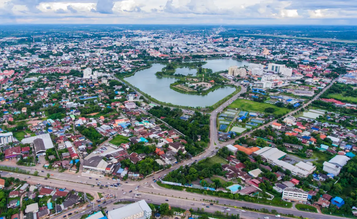
30 Best Places to Visit in Khon Kaen Khon Kaen is one of the major regional centers of Northeastern Thailand, combining a modern city with history, natural landscapes, Buddhist heritage, Isan culture, and important paleontological sites. Travelers can begin the day by paying respect at Phra Mahathat Kaen Nakhon beside Bueng Kaen Nakhon, walk around the city and sample local food, then drive out to Ubol Ratana Dam, follow the dinosaur trail through Phu Wiang, continue to Phu Pha Man for limestone mountains, caves, waterfalls, and spectacular bat flights, and complete the journey by learning about Mudmee silk in Chonnabot District or visiting Phra That Kham Kaen in Nam Phong District.
For travelers visiting Khon Kaen for the first time, the priority attractions are Wat Nong Waeng and Phra Mahathat Kaen Nakhon, Bueng Kaen Nakhon, Ubol Ratana Dam, Phu Wiang National Park, Phu Pha Man National Park, and Phu Wiang Dinosaur Museum. With 2–3 days, add Phra That Kham Kaen, King Cobra Village, and Sala Mai Thai. Travelers with 4–5 days can extend the journey to Phu Kao–Phu Phan Kham, Chum Phae District, and the natural attractions around Phu Pha Man, revealing Khon Kaen as a major city, a center of Isan culture, a dinosaur destination, and a province of mountains, forests, caves, and extensive reservoirs.
Khon Kaen lies in the central part of Northeastern Thailand and includes rolling plains, the floodplains of the Chi and Phong rivers, sandstone mountain ranges, and limestone mountains in the western part of the province. The Phu Wiang and Wiang Kao area is distinguished by a large sandstone mountain basin, while Phu Pha Man and Chum Phae connect with limestone ranges and natural forests. Ubol Ratana Dam has created a vast reservoir that plays important roles in electricity generation, irrigation, fisheries, and tourism.
Khon Kaen is important not only as a center of economy, education, medicine, and transportation in Isan, but also because of nationally significant archaeological and paleontological evidence. The Phu Wiang area is especially important as the starting point of systematic dinosaur discoveries in Thailand. These discoveries led to extensive fossil research and established “Phu Wiang” as one of the key names in Thai dinosaur paleontology.
From the perspective of human history, the Khon Kaen area has evidence of continuous settlement from prehistoric times through ancient communities of the Chi River basin and the development of the city during the Rattanakosin period. Sacred monuments such as Phra That Kham Kaen are therefore more than places of worship; they are symbols closely connected with the identity and name of the province. Wat Nong Waeng and Phra Mahathat Kaen Nakhon, meanwhile, represent the development of Isan Buddhist art within modern Khon Kaen city.
Culturally, Khon Kaen has a strong Isan identity expressed through Mor Lam music, the khaen, the Phuk Siao friendship tradition, silk craftsmanship, and Mudmee silk. Chonnabot District is particularly renowned as one of Thailand’s important Mudmee silk centers. The patterns are created by tying selected sections of silk yarn before dyeing, requiring careful calculation and precision. Sala Mai Thai therefore provides an important introduction to the relationship between weaving knowledge, community life, and the local economy.
Important provincial traditions include the International Silk Festival, the Phuk Siao Ceremony, the Khon Kaen Red Cross Fair, Bun Bang Fai rocket festivals, Songkran celebrations on Khao Niew Road, and Buddhist merit-making traditions in different communities. The word “Phuk Siao” reflects the Isan tradition of formal friendship, emphasizing bonds between individuals and families, while the silk festival demonstrates the continuing role of traditional crafts in contemporary provincial life.
Khon Kaen cuisine ranges from traditional Isan food to modern urban dining. One of the province’s best-known specialties is Khao Suan Kwang grilled chicken, together with som tam, larb, koi, nam tok, gaeng om, jaew dipping sauces, bamboo-shoot soup, and freshwater fish from rivers and reservoirs. Khon Kaen city also has numerous restaurants, cafés, night markets, and contemporary dining venues, making it easy to combine nature sightseeing with food and urban lifestyle experiences.
Dividing the province into travel zones makes planning easier. The Khon Kaen City Zone is best for Wat Nong Waeng, Bueng Kaen Nakhon, museums, and dining areas. The Ubol Ratana–Phu Phan Kham Zone focuses on Ubol Ratana Dam and reservoir landscapes. The Phu Wiang–Wiang Kao Zone is the main dinosaur, fossil, national park, and museum area. The Phu Pha Man–Chum Phae Zone is ideal for caves, waterfalls, limestone mountains, and bats. The Nam Phong Zone features Phra That Kham Kaen and King Cobra Village, while the Chonnabot Zone is best for learning about Mudmee silk and local textile wisdom.
If you have only 1 day in Khon Kaen city, a convenient route is Wat Nong Waeng – Bueng Kaen Nakhon – central Khon Kaen. Travelers with a car can choose Ubol Ratana Dam for a half-day or full-day excursion. With 2–3 days, add Phu Wiang and the dinosaur museum. A 4–5 day itinerary can include Phu Pha Man, Chonnabot, Nam Phong, and Phu Kao–Phu Phan Kham, providing a complete view of Khon Kaen through its city life, religion, dinosaurs, nature, silk culture, and Isan traditions.
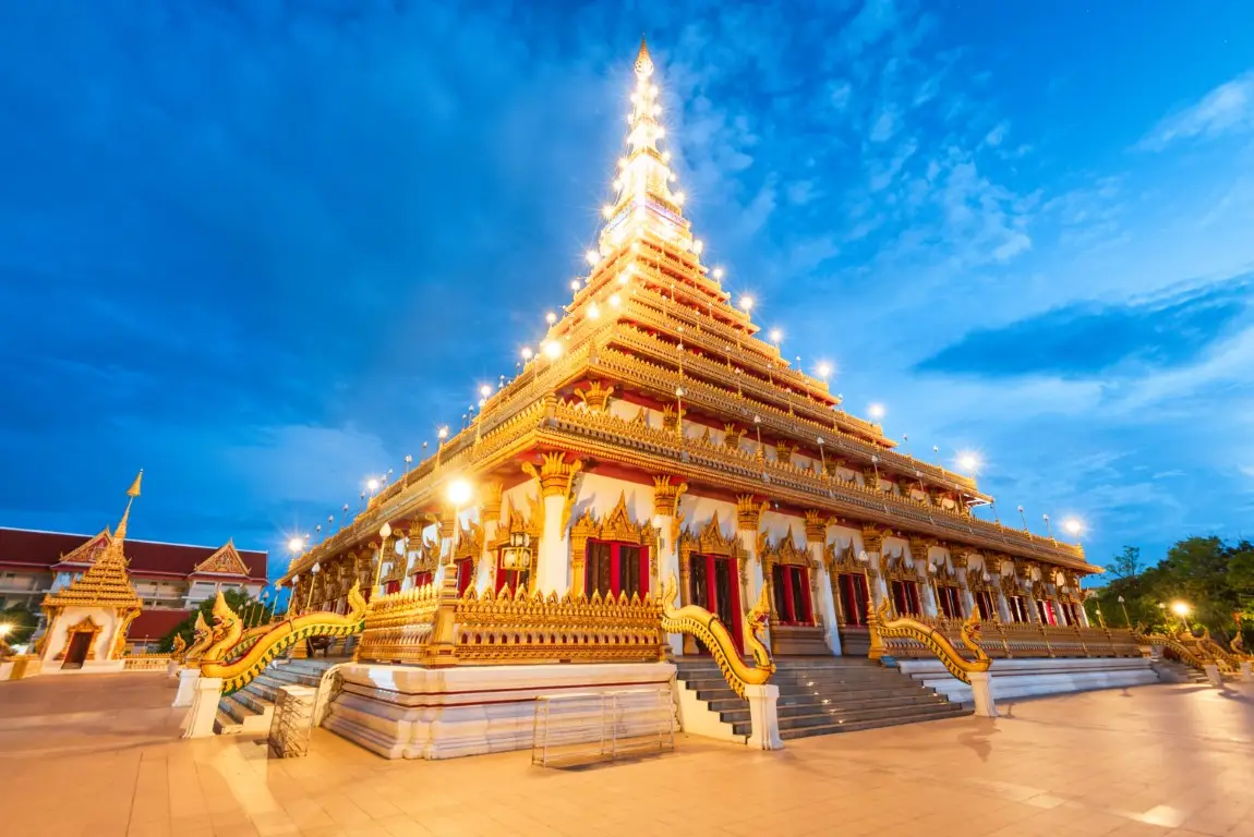
1. Wat Nong Waeng (Phra Mahathat Kaen Nakhon) is located on Klang Mueang Road beside Bueng Kaen Nakhon in Nai Mueang Subdistrict, Mueang Khon Kaen District. It is one of the province’s most important temples and most recognizable landmarks. At the heart of the temple stands Phra Mahathat Kaen Nakhon, a 9-storey sacred stupa that combines merit-making, Buddhist art, Isan culture, and panoramic views of Khon Kaen city.
Highlight: Phra Mahathat Kaen Nakhon rises approximately 80 meters and contains 9 levels, with a stupa-shaped upper section, 4 smaller corner stupas, a seven-headed Naga glass wall, Buddha relics, local murals and craftsmanship, and panoramic views over Bueng Kaen Nakhon and the surrounding city from the upper floors.
Phra Mahathat Kaen Nakhon is distinctive because it combines the architectural concept of an Isan-style sacred stupa with a multi-storey building. The exterior takes the form of a monumental stupa, while each interior level contains spaces for paying respect to Buddha images and relics and for viewing artworks connected with Buddhism and local culture.
Walking upward through the building gradually changes the visitor’s perspective from sacred interior spaces to the cityscape outside. From the upper floors, visitors can see Bueng Kaen Nakhon, nearby roads, and the surrounding urban districts, giving Wat Nong Waeng a different experience from conventional city temples focused solely on worship.
Wat Nong Waeng is a third-class royal temple of the ordinary type and remains an important center of Buddhist activities for the city community. Major Buddhist holy days and local merit-making traditions continue to keep the temple closely connected with the everyday spiritual life of Khon Kaen residents.
Another major advantage is the location beside Bueng Kaen Nakhon. Travelers can visit the temple during the morning and continue walking around the lake, or come in the late afternoon when softer light creates an attractive atmosphere around the stupa and waterfront. The two attractions work particularly well as a half-day city itinerary.
The temple is suitable for families, older travelers, merit-making visitors, photographers, and anyone visiting Khon Kaen for the first time. Visitors should dress respectfully and maintain a quiet atmosphere inside sacred areas. Those planning to explore several floors should allow enough time and rest when necessary.
Getting There: Wat Nong Waeng is located on Klang Mueang Road beside Bueng Kaen Nakhon, Nai Mueang Subdistrict, Mueang Khon Kaen District. It is easily accessible by private car, taxi, local hired vehicle, or city transport. Open daily from 08.00–18.00.
Map (GPS): https://www.google.com/maps/dir/?api=1&destination=16.409184,102.834113&travelmode=driving

2. Bueng Kaen Nakhon is a large lake and public park in central Khon Kaen covering approximately 603 rai. It functions as a major urban green space, recreation area, exercise destination, viewpoint for Phra Mahathat Kaen Nakhon, and a place closely connected with the memory of Khon Kaen’s founding.
Highlight: A large lake, lakeside walking and exercise routes, fitness areas, playgrounds, golden shower trees and ornamental plants, sculptures, the Chao Phia Mueang Phaen Monument, nearby restaurants, and excellent views toward Phra Mahathat Kaen Nakhon from across the water.
Bueng Kaen Nakhon is an urban public space genuinely used by local residents every day. In the morning, people come to walk, run, and exercise, while the atmosphere becomes livelier in the evening as residents relax after work and travelers arrive to enjoy the sunset beside the lake.
The importance of the lake extends beyond recreation. The surrounding area is connected with the history of Khon Kaen, including the monument to Chao Phia Mueang Phaen, an important figure in the city’s founding history. Walking around the lake can therefore combine leisure with an introduction to local history.
One of the most popular photography angles looks across the water toward Phra Mahathat Kaen Nakhon at Wat Nong Waeng. The scene becomes especially attractive in the evening when the sunlight softens and lights begin to appear around the lake.
The area is suitable for families, children, older travelers, couples, runners, and visitors looking for an easy attraction without an admission fee. It can be visited either before or after Wat Nong Waeng.
For travelers staying in central Khon Kaen, spending a morning or evening at Bueng Kaen Nakhon provides a better sense of everyday city life than visiting only major landmarks, because the lake remains an active public space used by local people throughout the year.
Getting There: Bueng Kaen Nakhon is located in Nai Mueang Subdistrict, Mueang Khon Kaen District, close to Wat Nong Waeng and the old city area. Access by private car or local hired vehicle is convenient. Open daily from 06.00–21.00.
Map (GPS): https://www.google.com/maps/dir/?api=1&destination=16.418546,102.840048&travelmode=driving

3. Ubol Ratana Dam (Phong Nip Dam) is located in Khuean Ubolratana Subdistrict, Ubolratana District. It is one of the most important multipurpose dams in Northeastern Thailand, built across the Phong River where it passes through a mountain gap between the Phu Kao and Phu Phan Kham ranges. The resulting reservoir plays major roles in power generation, water management, agriculture, fisheries, and tourism.
Highlight: The dam crest, vast reservoir, Phu Kao and Phu Phan Kham mountain scenery, Phra Phuttha Sirisattarat or Luang Pho Chet Kasat, reservoir-side recreation areas, restaurants, sunset viewpoints, and convenient connections to Bang Saen 2 and Phu Kao–Phu Phan Kham National Park.
Construction of Ubol Ratana Dam began in 1964 and was completed in 1966. The project became an important part of regional development during a period when irrigation and electricity infrastructure were expanding across Northeastern Thailand. The creation of the reservoir also transformed the landscape and economic life of communities around the Phong River.
For travelers, the main attraction is the expansive water scenery surrounded by mountain ridges. The dam crest and recreation areas provide wide views across the reservoir, particularly in the late afternoon and evening when the light is ideal for photography and sunset watching.
Communities around the reservoir remain closely connected with freshwater fishing, and local restaurants often feature fish dishes. A family trip can therefore combine sightseeing, a meal beside the reservoir, and visits to nearby attractions without requiring difficult walking routes.
The dam is suitable for families, older travelers, couples, groups of friends, and photographers. It is easier to explore than mountain attractions requiring trekking, although visitors should always follow regulations around power-generation facilities and avoid restricted areas.
Travelers with a full day can continue to Phu Kao–Phu Phan Kham National Park, Wat Phra Bat Phu Phan Kham, or Bang Saen 2, making the Ubol Ratana area one of the easiest nature and leisure day trips from Khon Kaen city.
Getting There: Ubol Ratana Dam is located in Khuean Ubolratana Subdistrict, Ubolratana District, Khon Kaen Province. A private car is the most convenient option from Khon Kaen city. Open daily from 07.00–20.00.
Map (GPS): https://www.google.com/maps/dir/?api=1&destination=16.775394,102.618325&travelmode=driving

4. Phu Wiang National Park covers parts of Wiang Kao, Phu Wiang, Si Chomphu, and Chum Phae districts. It is one of Thailand’s most important natural and paleontological areas because it was the starting point of systematic dinosaur discoveries in the country. The park also contains sandstone mountains, forests, waterfalls, caves, rock platforms, archaeological sites, and nature trails.
Highlight: Dinosaur fossil excavation sites, dinosaur footprints, sandstone mountain ranges, waterfalls, caves, prehistoric rock paintings, rock platforms, grasslands, dry dipterocarp forest, mixed deciduous forest, and nature-study trails.
Phu Wiang has a distinctive landscape resembling a large basin surrounded by mountain ridges. Exposed rock formations preserve extensive evidence of prehistoric life, making the area a major base for dinosaur exploration in Thailand and helping transform scientific understanding of the natural history of the Khorat Plateau.
The discovery of dinosaur bones at Huai Pratu Ti Ma in 1976 was one of the major events in Thai paleontology. Further exploration later revealed additional fossils and evidence that contributed to the identification and study of several dinosaur species associated with Thailand.
The national park covers approximately 325 square kilometers and was declared Thailand’s 71st national park on December 8, 1991. Beyond dinosaur sites, its varied natural landscapes allow visitors to combine scientific learning with forests, waterfalls, caves, and outdoor recreation.
The park is suitable for families, children, students, geology enthusiasts, nature travelers, and dinosaur lovers. Allow at least half a day, while visitors planning to explore several excavation areas together with the dinosaur museum should dedicate a full day.
The route connects naturally with Phu Wiang Dinosaur Museum, Si Wiang Dinosaur Park, and the dinosaur fossil excavation sites, making the Phu Wiang area one of the most complete educational tourism zones in Khon Kaen.
Getting There: The national park headquarters is in Wiang Kao District, Khon Kaen Province. A private car is the most convenient option. Open daily from 08.30–16.30. Visitors should check current park notices and trail conditions during periods of heavy rain.
Map (GPS): https://www.google.com/maps/dir/?api=1&destination=16.757636,102.257425&travelmode=driving
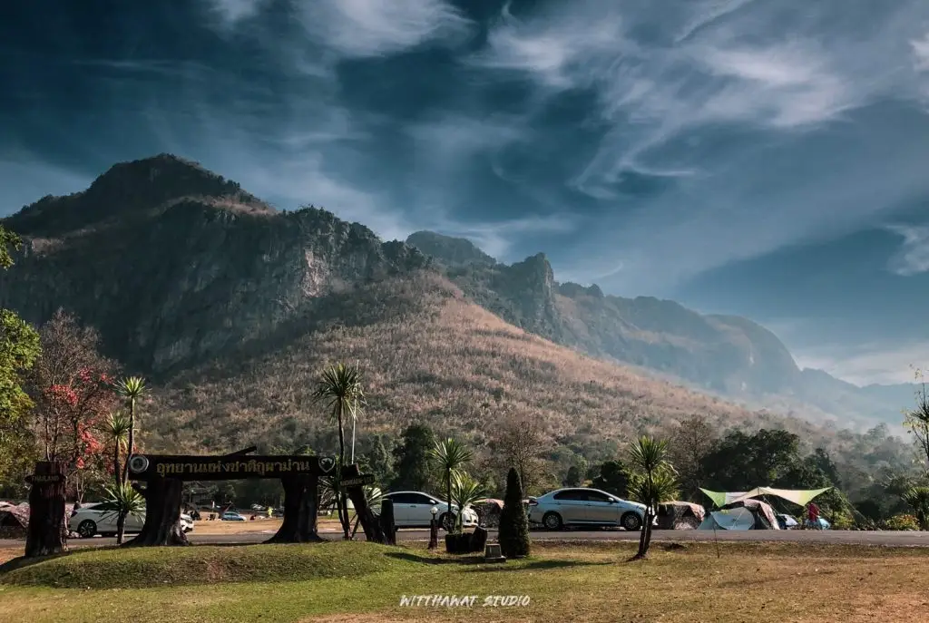
5. Phu Pha Man National Park covers Phu Pha Man and Chum Phae districts in Khon Kaen Province, together with adjoining areas of Loei Province. The park is distinguished by steep limestone cliffs stretching across the landscape like a giant curtain, creating one of the most recognizable natural settings in Khon Kaen.
Highlight: Limestone mountains, high cliffs, caves, stalactites and stalagmites, waterfalls, evergreen and mixed deciduous forest, Bat Cave, and the dramatic evening spectacle of enormous numbers of bats leaving their cave.
The park covers approximately 350 square kilometers. Its karst landscape was created through long-term dissolution and erosion of limestone, producing caves, underground cavities, cliffs, stone pillars, stalactites, and stalagmites. This makes the park valuable both for nature tourism and for understanding limestone geomorphology.
Phu Pha Man’s attractions are distributed across several areas rather than concentrated around the park headquarters. Major destinations include Bat Cave, Phaya Nakarat Cave, seasonal waterfalls, and various cave routes, so travelers should plan in advance whether they want to focus on caves, waterfalls, or the evening bat flight.
One of the area’s most memorable experiences occurs near Bat Cave in the evening, when huge numbers of bats stream out of the cave and form long moving lines across the sky. This natural spectacle depends on weather and wildlife behavior, so visitors should allow enough time and avoid disturbing the cave entrance.
Phu Pha Man is suitable for nature lovers, photographers, adventure travelers, groups of friends, and anyone looking for a quieter landscape away from the city. Footwear suitable for rocky terrain is recommended, and waterfall or cave conditions should be checked during the rainy season.
Travelers with 2 days can stay overnight in Phu Pha Man District and divide their time between caves, waterfalls, viewpoints, and the evening bat experience without rushing, before continuing toward Chum Phae or Phu Wiang.
Getting There: The national park headquarters is in Phu Pha Man District, Khon Kaen Province. A private car is the most convenient option. Open daily from 08.30–16.30. Some attractions may have seasonal access restrictions, so current park notices should be checked before traveling.
Map (GPS): https://www.google.com/maps/dir/?api=1&destination=16.743463,102.000490&travelmode=driving
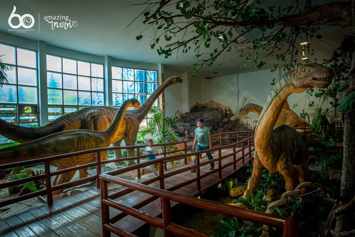
6. Phu Wiang Dinosaur Museum, officially known as the Dinosaur Research Centre and Museum, Khon Kaen Province, is located in Wiang Kao District. It is one of Thailand’s most important museums dedicated to dinosaurs, geology, and fossils because it is directly connected with the dinosaur discoveries of Phu Wiang.
Highlight: Dinosaur skeletons and life-size models, fossils, rocks and minerals, exhibitions on the origin of the Earth, the evolution of life, the story of dinosaur discoveries in Thailand, and information about scientific exploration of the Phu Wiang mountain range.
The museum’s importance lies in its role as a knowledge center rather than simply a place displaying dinosaur models. Its content connects basic geology, changes in the Earth, and life during the Mesozoic Era, helping visitors understand the geological context in which Phu Wiang fossils were found.
The discovery of Thailand’s first dinosaur fossil in the Phu Wiang area in 1976 by a geologist from the Department of Mineral Resources became the starting point for systematic dinosaur research. Further exploration revealed numerous fossils and contributed to the scientific study of several Thai dinosaur species.
The museum contains service, academic, and exhibition areas, making it suitable for a wide range of visitors, from young children and families to students and serious paleontology enthusiasts. Its indoor galleries also make it a good choice during the hottest part of the day.
Allow approximately 2–3 hours for the museum. To understand Phu Wiang more completely, combine it with Phu Wiang National Park or the fossil excavation sites, as seeing both museum exhibitions and the actual geological landscape provides a much more complete experience.
The museum is especially suitable for families with children because dinosaurs provide an engaging introduction to science, nature, and the history of the Earth. Visitors can also continue to Si Wiang Dinosaur Park afterward.
Getting There: The museum is located in Nai Mueang Subdistrict, Wiang Kao District, Khon Kaen Province. A private car is the most convenient option. Open Tuesday–Sunday from 09.30–16.30 and closed every Monday.
Map (GPS): https://www.google.com/maps/dir/?api=1&destination=16.678035,102.267055&travelmode=driving
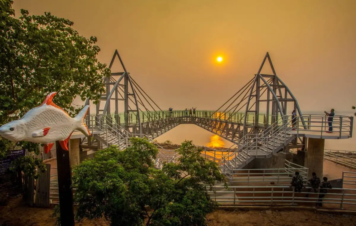
7. Phu Kao–Phu Phan Kham National Park is a national park linking the natural landscapes of Khon Kaen and Nong Bua Lamphu. The Phu Phan Kham section lies beside the reservoir above Ubol Ratana Dam, creating a destination that combines sandstone mountains, forest, viewpoints, water scenery, and archaeological evidence.
Highlight: The Phu Phan Kham range beside Ubol Ratana Reservoir, viewpoints, Phu Aen Skywalk, dry dipterocarp and mixed deciduous forests, nature trails, sandstone landscapes, caves, rock shelters, and prehistoric rock art or archaeological evidence in the Phu Kao area.
The park covers approximately 318 square kilometers and consists of 2 main mountain groups, Phu Kao and Phu Phan Kham. The Phu Kao section contains caves, rock shelters, and archaeological sites, while Phu Phan Kham provides broad views over Ubol Ratana Reservoir.
The sandstone landscape creates cliffs, rock platforms, and numerous viewpoints. At the same time, the forests function as important watershed areas and wildlife habitats, giving the park significant value for both tourism and conservation.
Travelers coming from Khon Kaen commonly enter through the Phu Phan Kham side because it connects easily with Ubol Ratana Dam. A convenient itinerary can begin at the dam and continue toward viewpoints or an overnight nature stay.
The park is suitable for nature travelers, photographers, couples, groups of friends, and anyone who enjoys mountain-and-reservoir scenery. Visitors planning to use nature trails should check opening times, permitted areas, and weather conditions in advance.
With additional time, the route can be combined with Bang Saen 2, Hat Chom Thong, and Wat Phra Bat Phu Phan Kham, creating an Ubol Ratana itinerary with water, mountains, religion, and recreation in the same area.
Getting There: The national park headquarters is in Ban Kho Subdistrict, Non Sang District, Nong Bua Lamphu Province, while the Phu Phan Kham side and adjoining attractions are easily accessible from Khon Kaen through Ubol Ratana Dam. Open daily from 08.30–16.30.
Map (GPS): https://www.google.com/maps/dir/?api=1&destination=16.810830,102.611639&travelmode=driving

8. Sala Mai Thai (Thai Silk Pavilion), officially known as the Queen Sirikit 60th Anniversary Commemorative Building, is located within Khon Kaen Industrial and Community Education College in Chonnabot District. It is one of Northeastern Thailand’s most important learning centers for Mudmee silk and sericulture wisdom and helps explain why Chonnabot is nationally recognized for high-quality silk craftsmanship.
Highlight: A 2-storey exhibition building, antique Mudmee silk, silk-yarn preparation, tying, dyeing and weaving processes, traditional weaving tools, SUPPORT Foundation-related craftsmanship, and silk products from communities across Northeastern Thailand.
Mudmee silk is distinguished by the process of tying selected sections of silk yarn before dyeing. When the ties are removed, protected sections remain undyed and the yarn can be woven into carefully planned patterns. The technique requires precise pattern calculation, accuracy, and extensive weaving experience.
Sala Mai Thai was created to preserve silk knowledge and continue traditional craftsmanship. Inside are old textiles, traditional tools, and product displays demonstrating that silk is not merely clothing but an important part of household economy, family life, social identity, and community traditions.
A visit provides a deeper understanding of silk than simply purchasing souvenirs because travelers can see how many stages are required to produce a single textile, from silk yarn and pattern planning to dyeing and hand weaving.
The attraction is suitable for students, families, designers, fashion enthusiasts, craft lovers, and travelers who want to purchase silk with a better understanding of its cultural value. The trip can also continue to weaving communities and silk shops around Chonnabot District.
Groups or visitors specifically interested in demonstrations should coordinate in advance when possible. Allow approximately 1–2 hours to explore the exhibitions in detail.
Getting There: Sala Mai Thai is located within Khon Kaen Industrial and Community Education College in Chonnabot District, Khon Kaen Province. Open Monday–Sunday from 08.30–16.30 and closed on public holidays.
Map (GPS): https://www.google.com/maps/dir/?api=1&destination=16.091082,102.609640&travelmode=driving
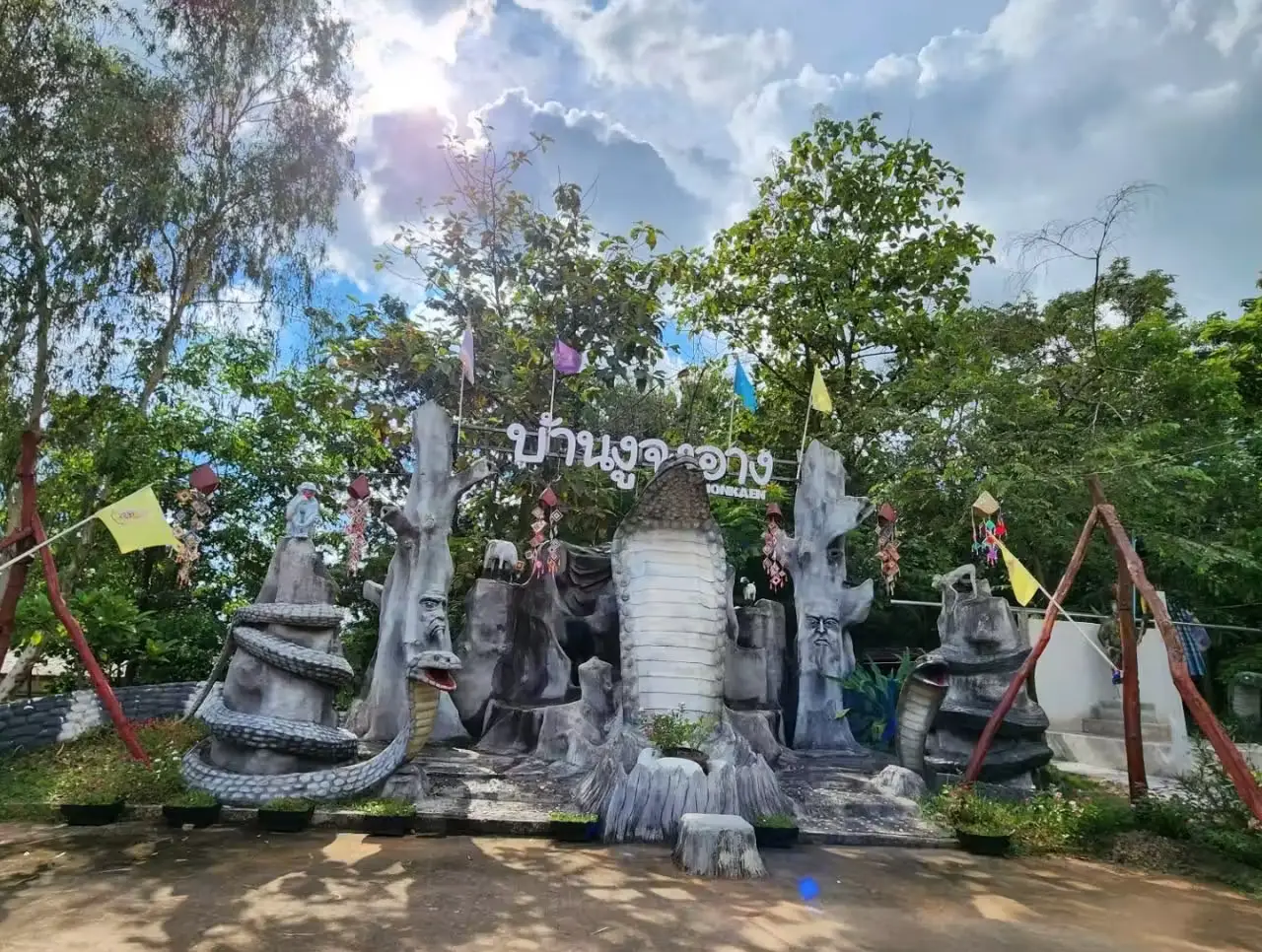
9. King Cobra Village, also known as Ban Khok Sa Nga, is located at Village No. 6, Sai Mun Subdistrict, Nam Phong District. The community is known for king cobra performances, traditional herbal knowledge, and the story of villagers who transformed snake demonstrations from a way of attracting customers for traditional medicine into a distinctive form of community tourism.
Highlight: King cobra performances, information about snakes and safety, traditional herbal medicine knowledge, the way of life of local snake handlers, and community products and souvenirs.
The story began with Ban Khok Sa Nga villagers who combined rice farming with selling traditional herbal medicine. Local herbal practitioners once traveled between communities to promote their remedies. In 1951, Ken Yongla introduced snakes into demonstrations to attract people and encourage them to listen to presentations about herbal products.
As the performances attracted greater attention, the community gradually developed its snake-handling demonstrations and accumulated specialized knowledge until Ban Khok Sa Nga became widely known. The village therefore represents an example of local knowledge and specialist skills being transformed into a distinctive tourism identity.
Visitors should watch performances only from designated areas and follow all safety instructions carefully. King cobras are highly venomous animals and should never be approached, handled, or imitated by inexperienced visitors.
The village is suitable for travelers interested in community culture, herbal medicine knowledge, and unusual local stories. Families with children should supervise them closely and emphasize learning about animal safety rather than physical interaction.
The visit can be combined with Phra That Kham Kaen in Nam Phong District, creating a route that combines community culture and Buddhist heritage before returning to Khon Kaen city or continuing toward Ubol Ratana Dam.
Getting There: King Cobra Village is located at Ban Khok Sa Nga, Village No. 6, Sai Mun Subdistrict, Nam Phong District, Khon Kaen Province. A private car is the most convenient option. Open daily from 09.00–16.00.
Map (GPS): https://www.google.com/maps/dir/?api=1&destination=16.697613,102.933727&travelmode=driving
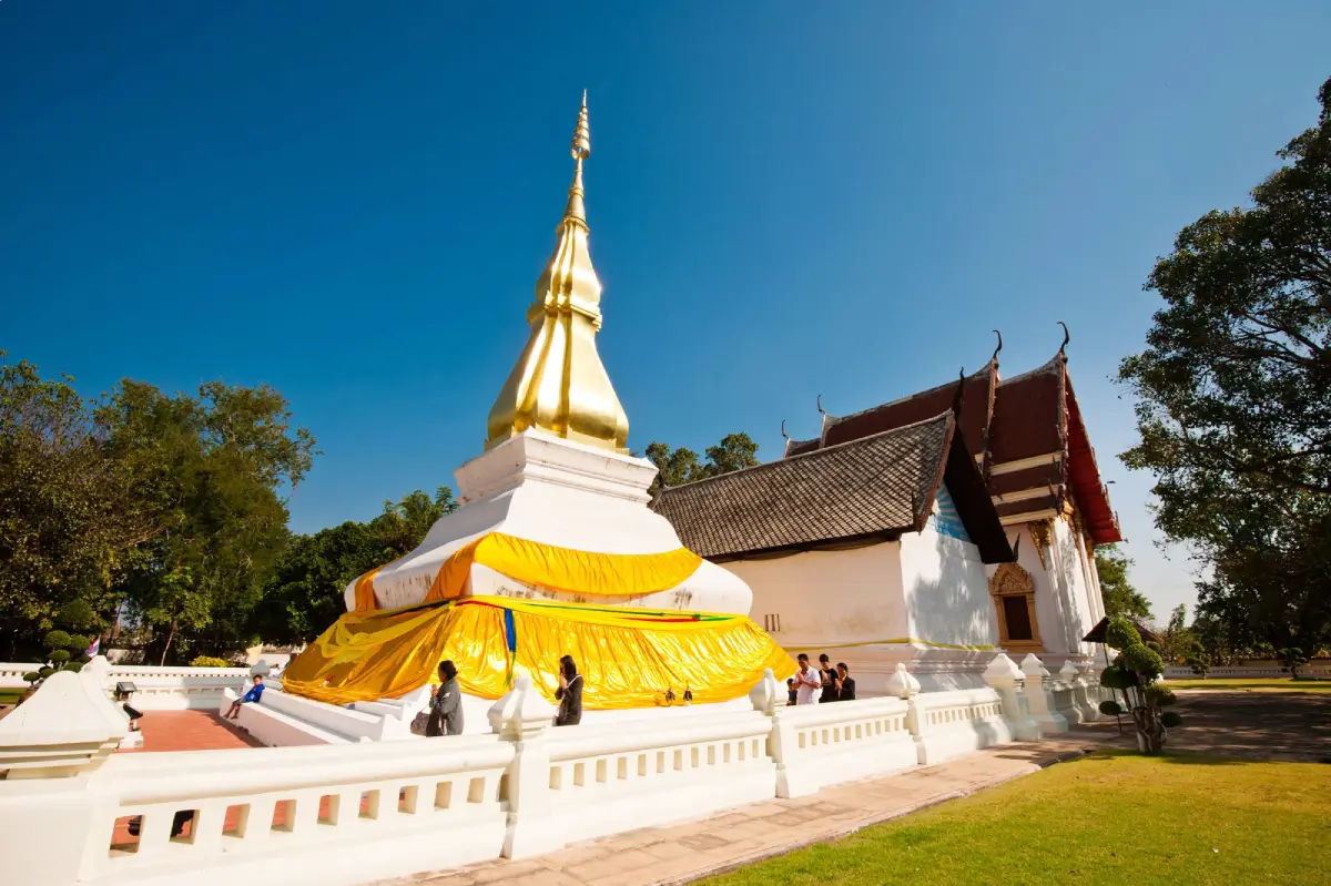
10. Phra That Kham Kaen is located within Wat Chetiyaphum at Ban Kham, Ban Kham Subdistrict, Nam Phong District. It is one of Khon Kaen’s most sacred monuments and an important symbol of the province. The name of the stupa is closely associated with the origin story of the name “Khon Kaen” through the legend of an old tamarind trunk that miraculously returned to life.
Highlight: The elegant white sacred stupa with a broad base and golden finial, the legend of the tamarind heartwood, Buddha relics, the peaceful atmosphere of Wat Chetiyaphum, and its role as a spiritual center for the Ban Kham community.
The legend of Phra That Kham Kaen is connected with the carrying of Buddha relics and a tamarind tree that had been reduced to its heartwood but unexpectedly sprouted leaves and came back to life. The event was interpreted as an auspicious sign and became associated with the construction of a sacred stupa at the site.
Although the legend is an important part of the monument’s identity, Phra That Kham Kaen is also significant as a continuously respected center of faith for local residents and people across Khon Kaen. The temple therefore combines religion, community history, and shared local memory.
The white stupa has a simple but graceful form, contrasting with its golden upper finial. The surrounding courtyard is open and spacious, making it suitable for circumambulation, worship, and photography, especially in the morning when the temperature is cooler and the temple atmosphere is peaceful.
Phra That Kham Kaen is suitable for merit-making travelers, families, older visitors, students, and anyone interested in local legends and cultural roots. While Wat Nong Waeng represents Buddhism within modern Khon Kaen city, Phra That Kham Kaen adds the dimension of older community belief and sacred tradition.
The site can be combined with King Cobra Village and other attractions in Nam Phong District in a half-day or full-day itinerary before continuing to Ubol Ratana Dam or returning to central Khon Kaen.
Getting There: Phra That Kham Kaen is located within Wat Chetiyaphum, Ban Kham, Ban Kham Subdistrict, Nam Phong District, Khon Kaen Province. A private car is convenient. Open daily from 05.00–19.00.
Map (GPS): https://www.google.com/maps/dir/?api=1&destination=16.563457,102.951862&travelmode=driving

11. Bang Saen 2 and Hat Chom Thong are located around Ban Hin Phoeng, Tha Ruea Subdistrict, Ubolratana District. This popular recreation area beside Ubol Ratana Reservoir is often described as a “freshwater sea” because of its shoreline, restaurants, floating dining areas, and wide reservoir views backed by mountain ranges. It is especially suitable for families, groups of friends, and travelers looking for an easy waterside escape without traveling to the coast.
Highlight: More than 1 kilometer of reservoir shoreline, a freshwater-beach atmosphere, restaurants and floating dining areas, sunset viewpoints, seasonal water activities, and views toward the Phu Kao mountain range surrounding the reservoir.
The name “Bang Saen 2” comes from the area’s resemblance to a seaside holiday destination, with a waterside beach, restaurants, and leisure activities. Instead of seawater, however, the landscape is formed by one of Northeastern Thailand’s largest reservoirs. Hat Chom Thong is part of the same reservoir recreation zone and is commonly mentioned together with Bang Saen 2.
The reservoir is broad enough to create an open horizon quite different from a typical small lake. On clear days, mountain ridges can be seen in the distance, while late-afternoon sunlight reflecting across the water makes this one of the more attractive photography locations around Ubol Ratana.
Restaurants along the shore commonly serve Isan food and freshwater fish dishes. Visitors can therefore plan a relaxed trip around eating beside the reservoir, enjoying the scenery, and spending time without a strict schedule. Weekends and public holidays can be busier, so extra time should be allowed for traffic and parking.
Waterside activities depend on reservoir levels, season, weather, and available local operators. Visitors should choose services that provide appropriate safety equipment and avoid swimming in deep-water areas or locations without supervision.
Bang Saen 2 combines well with Ubol Ratana Dam, Phu Kao–Phu Phan Kham National Park, and Wat Phra Bat Phu Phan Kham, making it possible to plan a full-day Ubol Ratana itinerary combining reservoir views, nature, religion, and local food.
Getting There: Located at Ban Hin Phoeng, Village No. 3, Tha Ruea Subdistrict, Ubolratana District, approximately 53 kilometers from Khon Kaen city. Follow the route toward Ubol Ratana Dam and continue to the reservoir recreation area. Open daily; 09.00–18.00 is the most practical period when restaurants and visitor services are generally available.
Map (GPS): https://www.google.com/maps/dir/?api=1&destination=16.739146,102.627485&travelmode=driving

12. Si Wiang Dinosaur Park is located at Ban Nong Na Kham or Ban Non Chan Kiao, Village No. 8, Mueang Kao Phatthana Subdistrict, Wiang Kao District. This dinosaur-themed public park covers approximately 25 rai and sits along the route toward Phu Wiang, with the Phu Wiang mountain range forming a natural backdrop. It is an ideal first stop for families and children beginning a dinosaur-themed trip.
Highlight: Numerous dinosaur models, landscaped gardens, fitness areas, an artificial waterfall, ponds, photography spots, and several dinosaur figures that can move or produce sounds, creating a playful prehistoric atmosphere before visitors continue to real fossil sites.
The park’s importance lies in its role as an accessible “gateway to Phu Wiang.” Children can become familiar with dinosaur shapes and diversity through large models before moving on to more scientific learning at Phu Wiang Dinosaur Museum and the real fossil excavation sites inside Phu Wiang National Park.
The landscaped grounds also function as a public recreation area, with walking paths, seating areas, green spaces, and numerous photography points. Visitors do not need to come only for dinosaur education; the park also works well as a short rest stop during a longer road trip.
Placing dinosaur models among trees with the mountains in the background creates a very different atmosphere from an indoor museum. This is especially useful for younger children who may not yet be ready for large amounts of scientific information, as seeing full-size models can build excitement before viewing real fossils.
The park is suitable for families, young children, students, and travelers looking for an easy stop without hiking. Visitors arriving during midday should bring hats and sun protection because parts of the park are exposed to direct sunlight.
It is best combined with Phu Wiang Dinosaur Museum, Phu Wiang National Park, and the dinosaur fossil excavation sites. Around 1 hour is generally enough for exploring Si Wiang Dinosaur Park before continuing the route.
Getting There: Located at Ban Nong Na Kham or Ban Non Chan Kiao, Village No. 8, Mueang Kao Phatthana Subdistrict, Wiang Kao District, along Route 2038. Open daily from 09.00–16.00.
Map (GPS): https://www.google.com/maps/dir/?api=1&destination=16.677797,102.340134&travelmode=driving
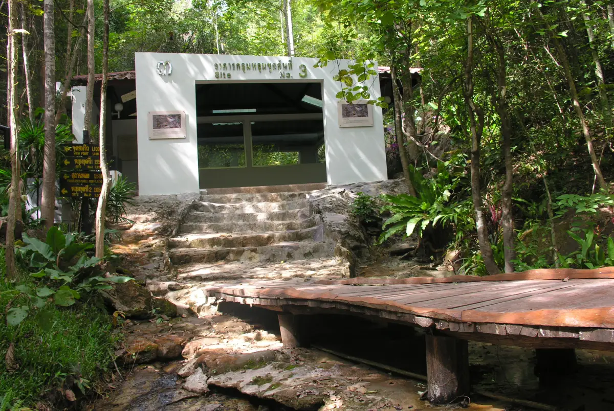
13. Dinosaur Fossil Excavation Site is located inside Phu Wiang National Park in Wiang Kao District. This is an authentic scientific site where dinosaur remains approximately 130 million years old have been discovered and studied, making it one of the most important places in the history of paleontology in Thailand.
Highlight: Real excavation pits, fossil-bearing rock layers, protective structures built over important finds, interpretive signs, nature trails, and the opportunity to see the relationship between dinosaur bones and geological layers in their original environment.
Phu Wiang became famous after dinosaur bone fragments were discovered during a geological survey in 1976. Continued excavation later revealed further evidence at several locations, marking the beginning of serious dinosaur research in Thailand.
The excavation sites help visitors understand paleontological fieldwork in a way that museum skeletons alone cannot. Visitors can see how fossils occur within rock layers, why excavation must be carried out carefully, and why the precise position of bones within geological strata is important when reconstructing ancient environments.
Fossils from Phu Wiang include herbivorous dinosaurs, carnivorous dinosaurs, and other animals that help explain ecosystems of the Mesozoic Era. Several discoveries have also contributed to the scientific study and identification of dinosaur species associated with Thailand.
The attraction is suitable for students, families, science enthusiasts, amateur geologists, and anyone who wants to see “real evidence” rather than only replicas. Visitors must stay on designated routes and should never touch or remove rocks or fossils from the site.
Visiting Phu Wiang Dinosaur Museum before or after the excavation sites is highly recommended. The museum provides the wider scientific context, while the excavation area shows the geological process and original discovery environment in a direct and tangible way.
Getting There: Located inside Phu Wiang National Park, Wiang Kao District, Khon Kaen Province. Visitors should follow the official park routes within the area. Open daily from 08.30–16.30. Trail conditions should be checked during the rainy season.
Map (GPS): https://www.google.com/maps/dir/?api=1&destination=16.757800,102.257339&travelmode=driving

14. Bat Cave is located along the limestone cliffs of Phu Pha Man in Phu Pha Man Subdistrict, Phu Pha Man District. It is one of Khon Kaen’s best-known wildlife spectacles, with enormous numbers of small bats emerging from the cave in long streams across the evening sky.
Highlight: Millions of bats leaving the cave continuously for approximately 30–45 minutes, a cave entrance situated on a limestone cliff roughly 100 meters above the ground, and the dramatic Phu Pha Man mountain range forming a natural backdrop.
The bats leave their roost to forage near dusk. As they begin to emerge, long dark streams form across the sky, sometimes changing direction together in wave-like patterns. This is a completely natural wildlife phenomenon rather than a scheduled human performance.
The cave interior is an important bat habitat characterized by darkness, high humidity, and large amounts of guano, so tourism should focus on observation from designated areas below the cliff rather than entering the roost itself.
The exact time at which the bats emerge can change according to season, weather, and light conditions. Heavy rain and unusual weather may affect their behavior, so visitors should arrive early and be prepared to wait.
The attraction is suitable for families, couples, photographers, nature enthusiasts, and children interested in wildlife. Visitors should avoid loud noises, bright lights directed toward the bats, and approaching the cave entrance without permission.
A good itinerary is to explore Phu Pha Man during the day and finish at Bat Cave in the evening. Travelers can visit Phaya Nakarat Cave, waterfalls, or other national-park attractions first and then arrive at the bat-viewing area before sunset.
Getting There: Located in Phu Pha Man Subdistrict, Phu Pha Man District, approximately 2.5 kilometers from the district office. The main viewing period is around 17.30–18.30. Visitors should arrive before the bats begin leaving the cave.
Map (GPS): https://www.google.com/maps/dir/?api=1&destination=16.667119,101.894393&travelmode=driving

15. Phaya Nakarat Cave is a large limestone cave within Phu Pha Man National Park. It contains several chambers, stalactites, stalagmites, and natural limestone walls formed through long geological processes, making it an excellent destination for travelers who want to experience the karst landscape of Phu Pha Man from inside the mountain.
Highlight: Multiple cave chambers, stalactites and stalagmites, natural limestone walls, a dark and quiet atmosphere, a walking route to the cave entrance, and an adventure experience very different from caves equipped with full lighting systems.
The cave formed as water gradually dissolved limestone and created cavities inside the mountain. Over time, calcium-rich water dripping through the cave deposited minerals that developed into stalactites, stalagmites, and other formations. These processes take extremely long periods, making every section of the cave a natural geological record.
Natural light does not reach many interior sections, so visitors need appropriate lighting equipment and should walk carefully. Some areas may be wet, slippery, or uneven, especially after rainfall.
Cave exploration is best suited to travelers with a reasonable level of physical fitness who enjoy less-developed natural attractions. Families with very young children, older travelers, or visitors with difficulty walking over rocks should assess the route before entering.
Visitors should avoid touching stalactites and stalagmites unnecessarily because oils from human skin can affect mineral deposition on their surfaces. Breaking, removing, or writing on cave formations is strictly inappropriate.
Phaya Nakarat Cave can be visited in the morning or afternoon before continuing to Bat Cave in the evening, creating a route that reveals both the underground geology of Phu Pha Man and the wildlife ecosystem outside the mountain.
Getting There: Located within Phu Pha Man National Park, Khon Kaen Province. Access involves both road travel and a natural walking route. Open daily from 08.30–16.30. Visitors should check trail conditions and follow park staff guidance before entering the cave.
Map (GPS): https://www.google.com/maps/dir/?api=1&destination=16.814029,101.956663&travelmode=driving

16. Tat Fa Waterfall is located near Ban Non Sung in Nai Mueang Subdistrict, Wiang Kao District, inside Phu Wiang National Park. This natural mountain waterfall is approximately 15 meters high, with water flowing over rock layers surrounded by forest, making it a relaxing addition to a dinosaur and fossil itinerary.
Highlight: A waterfall approximately 15 meters high, natural rock terraces, pools, forest scenery, a peaceful atmosphere, and especially lush surroundings during the rainy season and early cool season.
Tat Fa Waterfall reveals another side of Phu Wiang. Although many visitors know the area primarily for dinosaurs, the mountain range also contains forests, streams, and waterfalls that add natural variety to a paleontology-focused trip.
The rainy season through early winter generally provides the best chance of seeing stronger water flow and greener forest. Water volume depends on rainfall and upstream conditions, so the waterfall does not look the same throughout the year.
Wet rocks can become slippery. Visitors should wear footwear with good traction, avoid climbing steep sections, and stay out of pools when currents are strong or warning notices are in effect.
The waterfall is suitable for nature travelers, families whose children can manage the walking route, groups of friends, and photographers. It can also serve as a relaxing stop between fossil sites and other areas inside the national park.
A practical itinerary is to visit Phu Wiang National Park, Phu Wiang Dinosaur Museum, and the fossil excavation sites in the morning, then continue to Tat Fa Waterfall in the afternoon when weather and water conditions are suitable.
Getting There: Located near Ban Non Sung, Nai Mueang Subdistrict, Wiang Kao District, within Phu Wiang National Park. Open daily from 08.30–16.30. Visitors should check water levels and trail conditions during periods of heavy rain.
Map (GPS): https://www.google.com/maps/dir/?api=1&destination=16.743633,102.279373&travelmode=driving

17. Hong Moon Mung Khon Kaen City Museum is located inside the 200-Year Public Park building beside Bueng Kaen Nakhon. This city museum brings together the history of settlement, urban development, daily life, local wisdom, traditions, and collective memories of Khon Kaen.
Highlight: Exhibitions on the history of Khon Kaen, migration and settlement, Isan ways of life, household objects, local knowledge, traditions, and the transformation of Khon Kaen from a local agricultural community into one of Northeastern Thailand’s major urban centers.
In the Isan language, “Hong” refers to a hall or building, while “Moon Mung” means inherited heritage or treasured possessions. The museum’s name therefore conveys the idea of a “house of Khon Kaen’s heritage,” preserving not only objects but also stories, memories, and local knowledge.
The exhibitions demonstrate that Khon Kaen did not begin as a major economic and university city. It developed from agricultural settlements and migration, gradually expanding through systems of administration, trade, transportation, and infrastructure until becoming one of the principal centers of Isan.
The museum is particularly useful before or after walking around Bueng Kaen Nakhon because its exhibitions provide deeper context for the surrounding city, especially stories relating to early leaders, communities, and everyday life in earlier periods.
It is suitable for students, families, first-time visitors, and anyone interested in urban history. Allow around 1–2 hours, and consider it a good indoor option during the hottest part of the day.
The museum can easily be combined with Bueng Kaen Nakhon, Wat Nong Waeng, and other central Khon Kaen attractions, making it suitable for a half-day itinerary without long-distance travel.
Getting There: Located in the 200-Year Public Park building beside Bueng Kaen Nakhon, on the road around the lake, Nai Mueang Subdistrict, Mueang Khon Kaen District. Open Monday–Saturday from 09.00–17.00.
Map (GPS): https://www.google.com/maps/dir/?api=1&destination=16.419255,102.839154&travelmode=driving
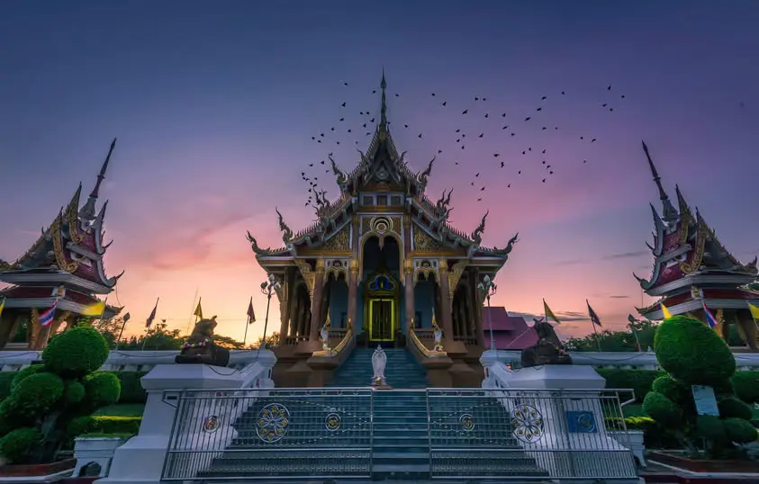
18. Wat Pa Saeng Arun (Isan Sim) is located at Ban Loeng Pueai, Phra Lap Subdistrict, Mueang Khon Kaen District, approximately 6 kilometers from the city center. This forest temple is especially notable for its Isan architecture, particularly the ordination hall, or “sim,” which preserves a strong regional artistic identity.
Highlight: An Isan-style sim combining upper-Isan architectural features with central Thai elements, murals inspired by Mudmee silk patterns, the principal Buddha image, and a quiet, shaded forest-temple atmosphere.
The temple was founded in 1930 by Phra Ajarn Thate Desaransi, widely known as Luang Pu Thate, together with Phra Ajarn Pin Panyaphalo. Local residents originally called the site Wat Pa Phra Khue before it later developed under the name Wat Pa Saeng Arun.
“Sim” is the Isan term for an ordination hall. The sim at Wat Pa Saeng Arun reflects an effort to preserve local architectural traditions while continuing to serve present-day Buddhist religious functions. Decorative details inside the building connect Buddhist art with the silk culture of Khon Kaen.
The mural patterns inspired by Mudmee silk are especially worth observing because they transfer motifs normally seen on textiles into architectural decoration. This demonstrates that silk is more than a commercial product; it is also a visual language deeply embedded in the cultural identity of the province.
The temple is suitable for merit-making travelers, photographers, students, visitors interested in Isan architecture, and anyone looking for a peaceful place close to the city. Visitors should dress respectfully and maintain quiet because the temple remains an active place of worship and meditation.
Wat Pa Saeng Arun can be combined with Wat Nong Waeng, Bueng Kaen Nakhon, and Hong Moon Mung Khon Kaen City Museum to create a 1-day cultural and religious route through the city and nearby areas.
Getting There: Located at Ban Loeng Pueai, Phra Lap Subdistrict, Mueang Khon Kaen District. From the city, follow Highway 12 or Si Chan Road toward Kalasin for approximately 6 kilometers. Open daily from 08.00–17.00.
Map (GPS): https://www.google.com/maps/dir/?api=1&destination=16.425417,102.885844&travelmode=driving

19. Nam Phong National Park covers approximately 197 square kilometers across several districts of Khon Kaen and parts of Chaiyaphum Province. The park features low mountain ranges, dry dipterocarp forest, dry evergreen forest, rock platforms, cliffs, watershed areas, and elevated views over Ubol Ratana Reservoir.
Highlight: Hin Chang Si viewpoint, natural sandstone formations, dry dipterocarp and dry evergreen forests, cliffs, views across Ubol Ratana Reservoir, nature trails, and the park’s role as an important watershed for both the Chi and Phong river systems.
Nam Phong National Park is ecologically important because its forests help retain soil moisture and protect watershed systems connected with the Chi River, Phong River, and Ubol Ratana Reservoir. Visitors can therefore clearly see the relationship between forest, mountain terrain, and major water resources.
One of the best-known attractions is Hin Chang Si, a sandstone rock area and viewpoint overlooking the broad waters of Ubol Ratana Reservoir. Sandstone erosion has created unusual rock formations and open platforms that are particularly attractive around sunset.
The park is suitable for nature travelers, photographers, couples, groups of friends, and visitors interested in nature trails. Late rainy season through early winter brings greener forest scenery, while the cool season offers more comfortable conditions for outdoor walking.
Some routes cross rocks and sloping terrain, so visitors should wear suitable footwear, carry drinking water, and remain on official trails. Extra caution is needed during rain because sandstone surfaces can become slippery.
Nam Phong National Park can be combined with Ubol Ratana Dam and Bang Saen 2. Travelers focusing on nature can spend half a day or a full day in the park and finish with dinner beside the reservoir.
Getting There: The park covers several districts of Khon Kaen Province, with major tourism areas accessible from the Ubol Ratana and Nong Ruea routes. Open daily from 08.30–17.00. Visitors should check current trail and weather notices before traveling.
Map (GPS): https://www.google.com/maps/dir/?api=1&destination=16.624376,102.570077&travelmode=driving

20. Khon Kaen Zoo Water Park, also known as “Sea on the Mountain,” is located inside Khon Kaen Zoo at 88 Moo 8, Kham Muang Subdistrict, Khao Suan Kwang District. It is a family recreation destination notable for its elevated setting, allowing visitors to enjoy water attractions while overlooking surrounding hills and countryside.
Highlight: Children’s pools, adult swimming areas, an approximately 450-meter lazy river, water-slide towers, several slide types, recreation areas, and a location inside Khon Kaen Zoo that makes it possible to combine wildlife viewing and water activities in a single day.
The name “Sea on the Mountain” reflects the experience of enjoying a large water park in the elevated landscape of Khao Suan Kwang. Although Khon Kaen has no coastline, the pools, lazy river, and water attractions create a beach-style recreational atmosphere with views very different from an urban water park.
A major advantage is its location inside Khon Kaen Zoo. Families can begin the morning by viewing animals and learning about nature, then move to the water park during the hotter part of the day, making it possible to build a full-day family itinerary in one destination.
The lazy river and slides provide activities for older children and teenagers, while separate children’s pools allow families with younger children to choose age-appropriate areas. Parents should supervise children closely and follow all safety regulations issued by staff.
Khao Suan Kwang is also famous for its food, particularly Khao Suan Kwang grilled chicken. Travelers can therefore combine the zoo and water park with a meal featuring one of Khon Kaen’s best-known local specialties.
Visitors should bring suitable swimwear, sun protection, and a change of clothes. Admission fees, operating conditions, and availability of individual rides should be checked on the travel date because services and charges can change.
Getting There: Located inside Khon Kaen Zoo, 88 Moo 8, Kham Muang Subdistrict, Khao Suan Kwang District, Khon Kaen Province. A private car is the most convenient option. Open daily from 10.00–18.00.
Map (GPS): https://www.google.com/maps/dir/?api=1&destination=16.845089,102.897130&travelmode=driving
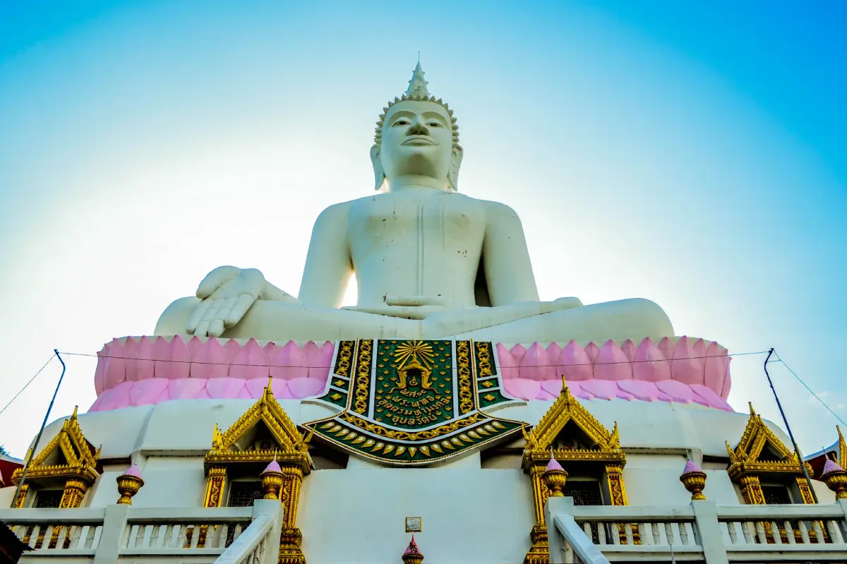
21. Wat Phra Bat Phu Phan Kham is located on the slope of Phu Phan Kham Mountain in Khuean Ubolratana Subdistrict, Ubolratana District. This important hilltop temple combines Buddhist pilgrimage, mountain walking, and panoramic views over Ubol Ratana Reservoir. Its most recognizable landmark is Luang Pho Yai, a large white Buddha image standing prominently above the surrounding mountain landscape.
Highlight: A replica Buddha footprint enshrined in a mondop, the approximately 14-meter-high Luang Pho Yai Buddha image, a 1,049-step Naga staircase, and a panoramic viewpoint overlooking Ubol Ratana Dam and the surrounding mountain ranges.
Visitors seeking a more traditional pilgrimage experience can climb the 1,049-step Naga staircase from the lower temple grounds to the summit. The route gradually opens views over the reservoir and surrounding hills, combining physical effort with a strong sense of spiritual journey.
Travelers who do not wish to climb the full staircase can drive to the upper area. This makes the temple accessible to older visitors, families with children, and people who want to enjoy the viewpoint without a strenuous ascent.
Luang Pho Yai is one of the defining visual symbols of the temple. The large white Buddha stands out clearly against the green mountain slopes and open sky, while the summit area provides space for worship, merit-making, resting, and photography.
The replica Buddha footprint is another important sacred feature. Many visitors stop to pay respect before continuing toward the mountaintop, making the temple suitable for both religious travel and scenic sightseeing.
Morning and late afternoon are the most comfortable times to visit because temperatures are lower and the light is better for photography. Visitors planning to use the staircase should carry drinking water and wear comfortable footwear.
The temple combines naturally with Ubol Ratana Dam, Bang Saen 2, Nam Phong National Park, and Phu Kao–Phu Phan Kham National Park, creating a full-day itinerary with religion, mountain scenery, reservoir views, and recreation.
Getting There: Located in Khuean Ubolratana Subdistrict, Ubolratana District, Khon Kaen Province. Open daily from 07.00–17.00.
Map (GPS): https://www.google.com/maps/dir/?api=1&destination=16.762627,102.625166&travelmode=driving

22. Tham Pha Phuang Forest Park is located at Ban Dong Lan, Na Nong Thum Subdistrict, Chum Phae District. It is a natural limestone-cave attraction with large chambers, stalactites, stalagmites, stone columns, and a route leading to elevated areas with views over the surrounding forest and mountain landscape.
Highlight: A large dry limestone cave, several connected cave chambers, stalactites, stalagmites, natural stone columns, limestone walls, shaded forest surroundings, and a scenic viewpoint near the upper approach.
Tham Pha Phuang is a clear example of karst topography. Rainwater and groundwater gradually dissolved the limestone over long periods, creating underground cavities, cave passages, and mineral formations of many different shapes.
Stalagmites develop upward from mineral deposits on the cave floor, while stalactites form downward from the ceiling. When both formations continue growing over long periods, they can eventually join to create natural stone columns.
The walking route toward the cave also provides views over forest and mountain scenery around Chum Phae. A visit therefore combines underground geology with light hiking and elevated landscape views.
Visitors should wear shoes with good grip, carry drinking water, and bring a flashlight when necessary. Avoid touching stalactites and stalagmites because oils from human skin can affect the delicate mineral surfaces.
The forest park is suitable for nature lovers, students, amateur geologists, photographers, groups of friends, and travelers looking for a natural stop between Chum Phae and Phu Pha Man.
Getting There: Located at Ban Dong Lan, Na Nong Thum Subdistrict, Chum Phae District, Khon Kaen Province. Open daily during daytime operating hours.
Map (GPS): https://www.google.com/maps/dir/?api=1&destination=16.570910,102.124671&travelmode=driving

23. Tat Yai Waterfall is one of the largest and most impressive waterfalls in Phu Pha Man National Park. It lies near the boundary between Phu Pha Man District in Khon Kaen Province and Nam Nao District in Phetchabun Province. Water descends through approximately 5 levels before reaching the dramatic final drop, which is around 80 meters high.
Highlight: Around 5 waterfall levels, an approximately 80-meter final cascade, forested mountain scenery, natural rock layers, hiking routes, and especially lush surroundings during the rainy season and early cool season.
Tat Yai is fed by mountain streams, so its appearance changes substantially throughout the year. The rainy season and early cool season provide the best chance of seeing strong water flow, while the dry season can reduce the waterfall considerably.
Reaching the waterfall requires more preparation than visiting a roadside cascade because parts of the journey involve forest and mountain terrain. It is therefore better suited to travelers who enjoy outdoor adventure and nature walking.
When water volume is high, the final drop creates mist around the lower area and produces one of the most dramatic waterfall scenes in Khon Kaen. Visitors should keep a safe distance from strong currents, wet rock surfaces, and cliff edges.
Wear hiking shoes or footwear with good grip, carry enough drinking water, and check weather conditions before entering the route. Heavy rainfall can cause rapid changes in water levels and trail safety.
Tat Yai can be combined with Phaya Nakarat Cave, Bat Cave, and other attractions in Phu Pha Man National Park. Travelers who want to explore the waterfall properly should allow at least half a day.
Getting There: Located inside Phu Pha Man National Park near the Khon Kaen–Phetchabun provincial boundary. Open daily from 08.30–16.30. Visitors should confirm current trail and water conditions with park staff before traveling.
Map (GPS): https://www.google.com/maps/dir/?api=1&destination=16.721116,101.783150&travelmode=driving

24. Tat Mok Waterfall is located near Ban Dong Sakhran, Wang Sawap Subdistrict, Phu Pha Man District. This seasonal waterfall flows through a mountain gorge and across natural rock layers surrounded by forest, making it especially attractive from the rainy season through the beginning of the cool season.
Highlight: Seasonal cascades over layered rock, lush Phu Pha Man forest, natural gorge scenery, rock platforms, and a peaceful atmosphere suitable for relaxation and nature photography.
Tat Mok has a more intimate character than the larger Tat Yai Waterfall. Water spreads through several rocky sections rather than forming only one major vertical drop, allowing visitors to observe the relationship between flowing water, stone surfaces, and forest at close range.
During periods of good rainfall, the forest becomes intensely green and humid and the waterfall is at its most attractive. During the dry season, water levels can decrease considerably, so the season strongly influences the experience.
Rock surfaces can become slippery, especially after rain. Visitors should not move too close to strong water currents and should check local route and water conditions before visiting.
The waterfall is suitable for nature lovers, groups of friends, photographers, and travelers who want to add a quieter seasonal waterfall to a Phu Pha Man itinerary.
It can be combined with Phu Ta Lo Cave, Bat Cave, and other attractions around Wang Sawap Subdistrict, making it possible to experience caves, mountains, and waterfalls in the same day.
Getting There: Located at Ban Dong Sakhran, Wang Sawap Subdistrict, Phu Pha Man District, Khon Kaen Province. Open daily from 08.30–16.30.
Map (GPS): https://www.google.com/maps/dir/?api=1&destination=16.695000,101.950000&travelmode=driving

25. Phu Ta Lo Cave (Tham Phu Ta Lor) is located near Ban Wang Sawap, Wang Sawap Subdistrict, Phu Pha Man District. This large limestone cave is known for its spacious chambers, stalactites, stalagmites, relatively level cave floor, and cool interior atmosphere.
Highlight: A large cave chamber, natural stalactites and stalagmites, limestone walls, relatively easy walking sections, mineral formations, and a cool and quiet underground environment.
The cave was formed through the gradual dissolution of limestone by rainwater and groundwater over very long periods. This process produced underground cavities, passages, and mineral formations characteristic of the karst landscape of Phu Pha Man.
Compared with more difficult cave routes, several sections of Phu Ta Lo have a relatively level floor, making exploration more manageable. Visitors should nevertheless wear shoes with good grip, carry lighting equipment, and walk carefully.
When flashlight beams illuminate the cave formations, visitors can see different layers, textures, and mineral patterns. These formations should be observed without touching them so that the natural surfaces remain undamaged.
The cave is suitable for families with older children, groups of friends, students, amateur geology enthusiasts, and travelers interested in caves without requiring highly technical adventure skills.
Visitors should coordinate with local officers or park staff before entering because guided access helps improve both safety and cave conservation. The dry season generally provides easier access conditions.
Phu Ta Lo Cave can be combined with Tat Mok Waterfall and Bat Cave. A practical plan is to explore the cave during the daytime and finish the day by watching bats emerge in the evening.
Getting There: Located near Ban Wang Sawap, Wang Sawap Subdistrict, Phu Pha Man District, approximately 17 kilometers from Phu Pha Man District Office. Open daily from 08.30–16.30 with prior coordination recommended.
Map (GPS): https://www.google.com/maps/dir/?api=1&destination=16.728001,101.848126&travelmode=driving

26. Dong Mueang Aem Ancient City is located at Ban Dong Mueang Aem, Dong Mueang Aem Subdistrict, Khao Suan Kwang District. It is a large ancient settlement where visitors can still observe the layout of the old town, surrounding moats, earthen embankments, laterite remains, and archaeological evidence within the original landscape.
Highlight: A rounded rectangular ancient-city plan, moats and earthen embankments, laterite ruins, pottery fragments, archaeological objects, and inscriptions that help explain the development of ancient communities on the Khorat Plateau.
The ancient city extends for roughly 2,400 meters from east to west and around 2,000 meters from north to south. Moats and earthworks surround the settlement, with multiple embankments surviving in some sections, demonstrating organized planning and landscape management.
Archaeological evidence reflects occupation associated with Dvaravati-period culture and later cultural influences. Dong Mueang Aem is therefore important for understanding the development of ancient communities in the Chi River basin and central Northeastern Thailand.
One of the site’s most valuable features is the ability to understand the ancient town through the actual landscape rather than only through objects displayed inside a museum. Following the lines of moats, embankments, and settlement areas helps visitors visualize the scale and organization of the historic community.
The attraction is suitable for history enthusiasts, archaeology travelers, students, and visitors who want to explore Khon Kaen beyond its best-known landmarks. Allow enough time to move through the site and examine its landscape carefully.
Dong Mueang Aem can be combined with Khon Kaen Zoo and other Khao Suan Kwang attractions, creating a day trip that combines archaeology, family activities, nature, and the district’s famous grilled chicken.
Getting There: Located at Ban Dong Mueang Aem, Dong Mueang Aem Subdistrict, Khao Suan Kwang District, approximately 40 kilometers from Khon Kaen city via Mittraphap Road. Open daily from 08.00–17.00.
Map (GPS): https://www.google.com/maps/dir/?api=1&destination=16.822739,102.807919&travelmode=driving
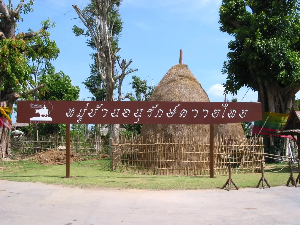
27. Thai Buffalo Conservation Village is located around Ban Non Udom and Ban Non Sawang, Na Wa Subdistrict, Phu Wiang District. This agricultural and cultural tourism community highlights the close relationship between Thai buffaloes and traditional Isan farming life.
Highlight: Thai buffaloes, rice fields, livestock areas, agricultural activities, traditional buffalo-raising knowledge, countryside photography, and rural scenery around the Ubol Ratana Reservoir landscape.
In the past, buffaloes were essential working animals for farming families. They were used for plowing rice fields, pulling carts, transporting goods, and supporting the household economy. Owning buffaloes therefore represented more than simply keeping livestock; it formed part of the entire rural production system.
As agricultural machinery increasingly replaced animal labor, buffalo numbers declined in many communities. Ban Non Udom and Ban Non Sawang became important places for preserving buffalo-raising knowledge and passing traditional agricultural practices to younger generations.
Visitors can experience a genuine rural setting with rice fields, animal areas, and the countryside environment in which buffaloes remain part of community life. This makes the village especially useful for children and students learning about Thai agriculture.
Activities can include buffalo-related learning, cart rides, traditional farming demonstrations, buffalo bathing, countryside experiences, and other community programs depending on current arrangements.
Visitors should maintain a safe distance from the animals, avoid standing directly behind buffaloes, and follow instructions from handlers. Buffaloes are large animals even when accustomed to people.
The village can be combined with Hat Sawan and attractions around Phu Wiang, creating a route that includes dinosaurs, reservoir scenery, agriculture, and rural culture in the same journey.
Getting There: Located around Ban Non Udom–Ban Non Sawang, Na Wa Subdistrict, Phu Wiang District, approximately 25 kilometers from Phu Wiang town. Open daily from 09.00–17.00.
Map (GPS): https://www.google.com/maps/dir/?api=1&destination=16.703508,102.559289&travelmode=driving

28. Khon Kaen Postal Museum is located on the 2nd floor of Khon Kaen Post Office on Klang Mueang Road. This compact museum presents the history of Thailand’s postal services, postage stamps, written communication, and the culture of philately.
Highlight: Thai and international postage stamps, postal history, information about the world’s first postage stamp, stamp-collecting equipment such as tongs, magnifying glasses and perforation gauges, and examples of stamp artwork from different periods.
Postage stamps are small objects capable of recording large amounts of social history. Their designs can reflect important people, historical events, traditions, nature, technology, and national identity from different periods.
The museum therefore offers an educational city attraction that can be explored without requiring much time. It also presents history from a very different perspective from city museums, temples, and archaeological attractions.
Stamp collectors can examine equipment and basic preservation methods, while children and students can learn how long-distance written communication worked before the internet and modern digital messaging.
Because the museum is located in central Khon Kaen, it can easily be combined with Hong Moon Mung Khon Kaen City Museum, Bueng Kaen Nakhon, Wat Nong Waeng, the City Pillar Shrine, and dining areas around the city center.
The museum is suitable for students, families, philatelists, and travelers interested in communication history. Most visitors can explore the main displays in around 45 minutes to 1 hour.
Getting There: Located on the 2nd floor of Khon Kaen Post Office, Klang Mueang Road, Nai Mueang Subdistrict, Mueang Khon Kaen District. Open Monday–Friday from 08.30–16.30 and closed on weekends and public holidays.
Map (GPS): https://www.google.com/maps/dir/?api=1&destination=16.429733,102.835802&travelmode=driving
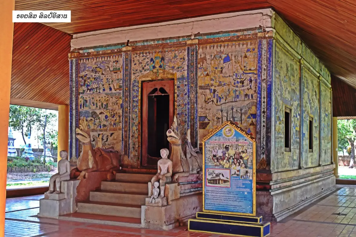
29. Wat Sa Bua Kaew is located at Ban Wang Khun, Village No. 4, Nong Mek Subdistrict, Nong Song Hong District. The temple is particularly important for its old Isan-style ordination hall, or sim, and its traditional mural paintings known locally as “Hoop Taem,” which preserve stories from Buddhism, folklore, beliefs, and everyday Isan life.
Highlight: A traditional brick-and-plaster Isan sim, murals on both interior and exterior walls, scenes from Buddhist Jataka stories and the Buddha’s life, images of heaven and hell, everyday village life, and local sculptures around the entrance.
“Sim” is the Isan word for an ordination hall. The sim at Wat Sa Bua Kaew is architecturally simple but culturally rich because its wall surfaces function as storytelling spaces, almost like a visual book created for the local community.
The Hoop Taem murals are not limited to Buddhist teachings. They also include clothing, houses, local customs, social relationships, animals, folklore, and imaginative representations of heaven and hell, allowing visitors to study art and Isan society at the same time.
The charm of folk painting lies in the freedom of its lines, colors, proportions, and composition. Unlike court painting, which usually follows more formal conventions, these murals feel closely connected with rural community experience and local storytelling traditions.
The temple is especially suitable for students, artists, historians, merit-making travelers, and visitors interested in Isan culture. Painted walls should never be touched or leaned against because old pigment layers can be fragile.
Wat Sa Bua Kaew is particularly valuable for travelers wanting to explore Khon Kaen beyond mainstream attractions. It adds an important dimension of local art and vernacular Buddhist architecture to an itinerary otherwise dominated by dinosaurs, nature, and urban landmarks.
Getting There: Located at Ban Wang Khun, Village No. 4, Nong Mek Subdistrict, Nong Song Hong District, Khon Kaen Province. Open daily from 09.00–17.00.
Map (GPS): https://www.google.com/maps/dir/?api=1&destination=15.751111,102.748812&travelmode=driving

30. Hat Sawan is located at Ban Non Sawan, Na Wa Subdistrict, Phu Wiang District. This freshwater beach and lakeside recreation area occupies approximately 62 rai along Ubol Ratana Reservoir and features a laterite-gravel shoreline, freshwater beach atmosphere, open views across the water, mountain scenery, and a peaceful rural setting.
Highlight: A freshwater beach beside Ubol Ratana Reservoir, picnic areas, camping space, sunrise and sunset viewpoints, mountain scenery, reservoir photography, and a quieter atmosphere than larger commercial waterside attractions.
Hat Sawan was developed from an open reservoir shoreline used by the local community. When water levels fall during certain periods, more of the beach becomes visible, creating additional space for walking, relaxing, and photography.
One of its strongest qualities is simplicity. The attraction is not dominated by large structures or intensive commercial activities, making it particularly suitable for slow travel, picnics, quiet landscape photography, and relaxation.
The reservoir also reflects the lives of local communities that depend on the water for fisheries, agriculture, and recreation. Hat Sawan is therefore more than a scenic viewpoint; it forms part of the living landscape around Ubol Ratana Reservoir.
The destination is suitable for families, couples, groups of friends, photographers, campers, and travelers looking for a quieter reservoir experience. Visitors should remain aware that water levels change seasonally and should avoid swimming in areas without safety supervision.
Hat Sawan can be combined with Thai Buffalo Conservation Village and attractions around Phu Wiang, allowing travelers to experience dinosaurs, farming culture, rural communities, and reservoir scenery within the same regional route.
Getting There: Located at Ban Non Sawan, Na Wa Subdistrict, Phu Wiang District, Khon Kaen Province. The public area is open 24 hours, but the recommended visiting time is 06.00–18.00 for visibility, convenience, and safety.
Map (GPS): https://www.google.com/maps/dir/?api=1&destination=16.679085,102.566776&travelmode=driving
| Topic | Details |
| Province Overview | Khon Kaen is one of the major centers of Northeastern Thailand, combining a modern city, important Buddhist sites, nationally significant dinosaur attractions, reservoirs, mountains, caves, waterfalls, forests, Mudmee silk culture, Isan art, agricultural communities, and famous local food. The province is suitable for trips ranging from 1 day to 4–5 days or longer. |
| Top 10 Highlights | 1. Wat Nong Waeng (Phra Mahathat Kaen Nakhon) 2. Bueng Kaen Nakhon 3. Ubol Ratana Dam 4. Phu Wiang National Park 5. Phu Pha Man National Park 6. Phu Wiang Dinosaur Museum 7. Phu Kao–Phu Phan Kham National Park 8. Sala Mai Thai 9. King Cobra Village 10. Phra That Kham Kaen |
| Khon Kaen City Zone | 1. Wat Nong Waeng 2. Bueng Kaen Nakhon 3. Hong Moon Mung Khon Kaen City Museum 4. Wat Pa Saeng Arun 5. Khon Kaen Postal Museum This zone is ideal for a half-day or 1-day itinerary because it combines religion, city history, public recreation, and local culture with convenient transportation. |
| Ubol Ratana–Phu Phan Kham Zone | 1. Ubol Ratana Dam 2. Phu Kao–Phu Phan Kham National Park 3. Bang Saen 2 and Hat Chom Thong 4. Nam Phong National Park 5. Wat Phra Bat Phu Phan Kham This zone is especially good for reservoir views, mountain scenery, viewpoints, waterside relaxation, and merit-making within a single route. |
| Phu Wiang–Wiang Kao Zone | 1. Phu Wiang National Park 2. Phu Wiang Dinosaur Museum 3. Si Wiang Dinosaur Park 4. Dinosaur Fossil Excavation Site 5. Tat Fa Waterfall 6. Thai Buffalo Conservation Village 7. Hat Sawan This is the best zone for families, children, students, and travelers interested in dinosaurs, nature, agriculture, and reservoir landscapes. |
| Phu Pha Man–Chum Phae Zone | 1. Phu Pha Man National Park 2. Bat Cave 3. Phaya Nakarat Cave 4. Tham Pha Phuang Forest Park 5. Tat Yai Waterfall 6. Tat Mok Waterfall 7. Phu Ta Lo Cave Recommended for nature lovers and adventure travelers interested in caves, waterfalls, limestone mountains, geology, and the evening bat flight. |
| Nam Phong Zone | 1. Phra That Kham Kaen 2. King Cobra Village A good half-day route for spiritual travel and community learning, and it can also be combined with the Ubol Ratana area. |
| Chonnabot Zone | 1. Sala Mai Thai The main destination for learning about Mudmee silk, silk tying, dyeing, weaving, traditional craftsmanship, and the cultural and economic importance of silk in Isan communities. |
| Khao Suan Kwang Zone | 1. Khon Kaen Zoo Water Park 2. Dong Mueang Aem Ancient City Suitable for families and history enthusiasts. The route can also include a meal of famous Khao Suan Kwang grilled chicken. |
| Nong Song Hong Zone | 1. Wat Sa Bua Kaew Recommended for travelers interested in Isan-style ordination halls, Hoop Taem murals, folk painting, local history, and vernacular Buddhist art beyond the province’s mainstream tourism routes. |
| Dinosaurs and Paleontology | 1. Phu Wiang National Park 2. Phu Wiang Dinosaur Museum 3. Si Wiang Dinosaur Park 4. Dinosaur Fossil Excavation Site Phu Wiang is one of Thailand’s most important areas for dinosaur discovery and research and can easily be developed into a full-day educational itinerary. |
| Nature and National Parks | 1. Phu Wiang National Park 2. Phu Pha Man National Park 3. Phu Kao–Phu Phan Kham National Park 4. Nam Phong National Park 5. Tham Pha Phuang Forest Park |
| Caves and Limestone Landscapes | 1. Bat Cave 2. Phaya Nakarat Cave 3. Phu Ta Lo Cave 4. Tham Pha Phuang Forest Park Phu Pha Man and Chum Phae are the main areas for cave tourism and exploring the karst landscape of Khon Kaen. |
| Waterfalls | 1. Tat Fa Waterfall 2. Tat Yai Waterfall 3. Tat Mok Waterfall All 3 are seasonal natural attractions. The rainy season through early cool season is generally the best period for stronger water flow and greener forest scenery. |
| Dams and Freshwater Beaches | 1. Ubol Ratana Dam 2. Bang Saen 2 and Hat Chom Thong 3. Hat Sawan Suitable for relaxation, reservoir views, waterside dining, photography, picnics, and sunset watching. |
| Merit-Making and Spiritual Travel | 1. Wat Nong Waeng 2. Phra That Kham Kaen 3. Wat Phra Bat Phu Phan Kham 4. Wat Pa Saeng Arun 5. Wat Sa Bua Kaew |
| History and Archaeology | 1. Dong Mueang Aem Ancient City 2. Hong Moon Mung Khon Kaen City Museum 3. Wat Sa Bua Kaew 4. Phra That Kham Kaen These attractions cover ancient settlements, moats and earthen embankments, city history, local Buddhist art, and traditional beliefs. |
| Isan Culture and Local Wisdom | 1. Sala Mai Thai 2. Wat Pa Saeng Arun 3. Wat Sa Bua Kaew 4. Thai Buffalo Conservation Village 5. King Cobra Village These places are useful for learning about Mudmee silk, Isan-style sim architecture, Hoop Taem murals, agricultural life, and distinctive community knowledge. |
| Best for Families | 1. Phu Wiang Dinosaur Museum 2. Si Wiang Dinosaur Park 3. Bueng Kaen Nakhon 4. Ubol Ratana Dam 5. Khon Kaen Zoo Water Park 6. Sala Mai Thai 7. Hat Sawan 8. Thai Buffalo Conservation Village |
| Best for Children | Phu Wiang Dinosaur Museum and Si Wiang Dinosaur Park are the best choices for children. They can be followed by Khon Kaen Zoo Water Park, Thai Buffalo Conservation Village, and Bueng Kaen Nakhon for additional wildlife, nature, and recreation experiences. |
| Best for Older Travelers | 1. Wat Nong Waeng 2. Bueng Kaen Nakhon 3. Ubol Ratana Dam 4. Phra That Kham Kaen 5. Sala Mai Thai 6. Wat Phra Bat Phu Phan Kham using the road to the upper area 7. Hong Moon Mung Khon Kaen City Museum 8. Khon Kaen Postal Museum |
| Best for Photography | 1. Wat Nong Waeng 2. Bueng Kaen Nakhon 3. Ubol Ratana Dam 4. Wat Phra Bat Phu Phan Kham 5. Bat Cave 6. Tat Yai Waterfall 7. Hat Sawan 8. Bang Saen 2 9. Phu Kao–Phu Phan Kham National Park 10. Nam Phong National Park |
| Best for Adventure Travelers | 1. Phu Pha Man National Park 2. Phaya Nakarat Cave 3. Phu Ta Lo Cave 4. Tat Yai Waterfall 5. Tat Mok Waterfall 6. Tham Pha Phuang Forest Park 7. Nam Phong National Park Wear footwear with good grip, carry drinking water and rain protection, and check trail conditions before entering natural areas. |
| Famous Local Food | Popular Khon Kaen dishes include Khao Suan Kwang grilled chicken, som tam, larb, koi, nam tok, gaeng om, jaew dipping sauces, bamboo-shoot soup, and freshwater fish from areas around Ubol Ratana Dam. Khon Kaen city also has a large selection of Isan restaurants, cafés, and contemporary dining venues. |
| Souvenirs | 1. Chonnabot Mudmee silk 2. Clothing and products made from silk 3. Isan handicrafts 4. Processed local foods 5. Dinosaur-themed souvenirs from the Phu Wiang area |
| Important Festivals and Traditions | The International Silk Festival, Phuk Siao tradition, and Khon Kaen Red Cross Fair are among the province’s major annual events. Other important traditions include Songkran on Khao Niew Road, Bun Bang Fai rocket festivals, Buddhist merit-making events, and community festivals that reflect Isan culture. |
| 1-Day City Itinerary | Morning: Wat Nong Waeng – Phra Mahathat Kaen Nakhon Late Morning: Hong Moon Mung Khon Kaen City Museum Afternoon: Khon Kaen Postal Museum or Wat Pa Saeng Arun Evening: Walk around Bueng Kaen Nakhon and enjoy dinner in the city |
| 1-Day Ubol Ratana Itinerary | Morning: Wat Phra Bat Phu Phan Kham Late Morning: Ubol Ratana Dam Afternoon: Phu Kao–Phu Phan Kham National Park or Nam Phong National Park Evening: Bang Saen 2 and Hat Chom Thong |
| 1-Day Phu Wiang Itinerary | Morning: Phu Wiang Dinosaur Museum Late Morning: Si Wiang Dinosaur Park Noon–Afternoon: Phu Wiang National Park and Dinosaur Fossil Excavation Site Late Afternoon: Tat Fa Waterfall or Hat Sawan depending on season and conditions |
| 1-Day Phu Pha Man Itinerary | Morning: Phaya Nakarat Cave or Phu Ta Lo Cave Afternoon: Tat Mok Waterfall or Tat Yai Waterfall Evening: Bat Cave to watch the bats emerge |
| 2 Days, 1 Night | Day 1: Khon Kaen city – Wat Nong Waeng – Bueng Kaen Nakhon – Ubol Ratana Dam Day 2: Phu Wiang Dinosaur Museum – Phu Wiang National Park – Dinosaur Fossil Excavation Site |
| 3 Days, 2 Nights | Day 1: Khon Kaen city Day 2: Ubol Ratana–Phu Phan Kham Day 3: Phu Wiang dinosaur route, or choose Phu Pha Man for a nature-focused trip |
| 4–5 Day Itinerary | Add Phu Pha Man, Chum Phae, Sala Mai Thai, Phra That Kham Kaen, King Cobra Village, Dong Mueang Aem Ancient City, Wat Sa Bua Kaew, and Thai Buffalo Conservation Village for a more complete view of Khon Kaen through its city life, dinosaurs, nature, religion, art, and rural communities. |
| Best Time to Visit | Khon Kaen can be visited throughout the year. November–February is especially suitable for hiking, mountain areas, caves, and viewpoints because temperatures are cooler. The rainy season is best for waterfalls and green forests such as Tat Yai, Tat Mok, and Tat Fa, while museums, temples, and city attractions are suitable year-round. |
| Getting Around the Province | Transportation within Khon Kaen city is relatively convenient, but attractions outside the city are spread across many districts. A private car or rental vehicle is the most practical option. Organizing the trip by travel zones helps reduce unnecessary backtracking. |
| Safety | Check weather conditions before visiting caves, waterfalls, and mountain trails. Rocks can become slippery during the rainy season, and visitors should stay away from cliff edges and strong currents. National park regulations should always be followed. At King Cobra Village, watch performances only from designated areas and do not touch snakes without permission. |
| Responsible Travel | Do not remove fossils, rocks, plants, or natural objects from protected areas. Avoid touching cave formations, do not use bright lights or loud noises to disturb bats, take all rubbish away from natural attractions, and support local silk, food, and community products whenever possible. |
Frequently Asked Questions (FAQ)
Q: What are the must-visit attractions in Khon Kaen?
A: Major highlights include Wat Nong Waeng and Phra Mahathat Kaen Nakhon, Bueng Kaen Nakhon, Ubol Ratana Dam, Phu Wiang National Park, Phu Wiang Dinosaur Museum, Phu Pha Man National Park, Phra That Kham Kaen, and Wat Phra Bat Phu Phan Kham. Together, these attractions represent the best of Khon Kaen’s city life, religion, nature, and dinosaur heritage.
Q: Where should I go if I have only 1 day in Khon Kaen?
A: If you are staying in the city without a car, visit Wat Nong Waeng, Hong Moon Mung Khon Kaen City Museum, and Bueng Kaen Nakhon. If you have a car and prefer nature, choose Ubol Ratana Dam or the Phu Wiang area for a full-day trip.
Q: How many days should I spend in Khon Kaen?
A: 2 days and 1 night are enough for Khon Kaen city plus either Phu Wiang or Ubol Ratana. If you also want to visit Phu Pha Man, Sala Mai Thai, Phra That Kham Kaen, and local communities, allow 3–5 days.
Q: Where are the dinosaur attractions in Khon Kaen?
A: The main dinosaur attractions are concentrated in the Phu Wiang area and include Phu Wiang Dinosaur Museum, Phu Wiang National Park, the Dinosaur Fossil Excavation Site, and Si Wiang Dinosaur Park. They can easily be combined into a full-day route.
Q: Why is Phu Wiang important to dinosaur history in Thailand?
A: Phu Wiang is one of the most important areas in the history of dinosaur discovery in Thailand. Dinosaur bones were found during a geological survey in 1976, leading to systematic excavation and continued scientific study of fossils in the area.
Q: Which part of Khon Kaen is best for nature?
A: Phu Pha Man is best for caves, waterfalls, and limestone mountains. Ubol Ratana is ideal for reservoir and mountain scenery, while Phu Wiang combines dinosaur sites with forest, waterfalls, and natural landscapes.
Q: What time should I visit Bat Cave in Phu Pha Man?
A: Arrive before sunset. The main viewing period is generally around 17.30–18.30, although the exact time can change according to season, weather, and the natural behavior of the bats.
Q: What waterfalls should I visit in Khon Kaen?
A: The main waterfalls are Tat Yai and Tat Mok in the Phu Pha Man area and Tat Fa inside Phu Wiang National Park. The rainy season through early cool season usually provides the best water flow and greenest surroundings.
Q: What are the best family attractions in Khon Kaen?
A: Recommended places include Phu Wiang Dinosaur Museum, Si Wiang Dinosaur Park, Bueng Kaen Nakhon, Ubol Ratana Dam, Khon Kaen Zoo Water Park, Sala Mai Thai, and Thai Buffalo Conservation Village.
Q: What are the best temples and spiritual attractions in Khon Kaen?
A: Major spiritual attractions include Wat Nong Waeng, Phra That Kham Kaen, Wat Phra Bat Phu Phan Kham, Wat Pa Saeng Arun, and Wat Sa Bua Kaew. Each site offers different religious, historical, or artistic significance.
Q: Where is Phra Mahathat Kaen Nakhon?
A: Phra Mahathat Kaen Nakhon is located inside Wat Nong Waeng beside Bueng Kaen Nakhon in Mueang Khon Kaen District. The 9-storey stupa is one of the province’s best-known landmarks.
Q: Why is Phra That Kham Kaen important?
A: Phra That Kham Kaen is one of the province’s most sacred monuments and a major spiritual center for Ban Kham community. Its legend is associated with a tamarind trunk that miraculously sprouted again and is closely connected with the identity and name of Khon Kaen.
Q: Does Khon Kaen have beaches?
A: Khon Kaen has no sea coast, but it has freshwater beaches along Ubol Ratana Reservoir, including Bang Saen 2, Hat Chom Thong, and Hat Sawan. These areas are suitable for picnics, relaxation, photography, and reservoir views.
Q: What souvenirs should I buy in Khon Kaen?
A: Chonnabot Mudmee silk is one of the province’s signature souvenirs. Other choices include silk clothing and accessories, Isan handicrafts, processed local foods, and dinosaur-themed souvenirs from the Phu Wiang area.
Q: What food is Khon Kaen famous for?
A: Khao Suan Kwang grilled chicken is one of the province’s best-known specialties. Other popular foods include som tam, larb, koi, nam tok, gaeng om, jaew, bamboo-shoot soup, and freshwater fish dishes from areas around Ubol Ratana Dam.
Q: What is the best time to visit Khon Kaen?
A: November–February is especially comfortable for outdoor sightseeing, mountain trips, caves, and national parks because temperatures are cooler. The rainy season is better for waterfalls and lush forests, while museums, temples, and city attractions can be visited year-round.
Q: Can I travel around Khon Kaen without a private car?
A: Khon Kaen city is relatively easy to explore using local transport and hired vehicles. However, attractions such as Phu Wiang, Phu Pha Man, Ubol Ratana, Chonnabot, and Nam Phong are spread across the province, so renting a car or hiring a vehicle with a driver is much more convenient.
Q: What are the best adventure attractions in Khon Kaen?
A: Recommended adventure destinations include Phu Pha Man National Park, Phaya Nakarat Cave, Phu Ta Lo Cave, Tham Pha Phuang Forest Park, Tat Yai Waterfall, Tat Mok Waterfall, and Nam Phong National Park. Always check weather and trail conditions before entering natural areas.
 Category: ●Travel Articles, Recipes
 Group: ●Travel Review, Food Review
Last Update : 3 WeekAgo
 Last Update : 3 WeekAgo
Recommend

 Art, Culture and Heritage
 Historical Sites and Monuments(7)
 Landmarks and Memorials(3)
 Art, Craft Centres, Tradition(2)
 Museums(4)
 Educational Places
 Museum for Study(2)
 Places of Worship
 Temple(27)
 Other Sacred Sites(5)
 Suburban Living
 Village, Community(3)
 Local Market(1)
 Nature and Wildlife
 National Parks and Marine Reserves(5)
 Mountain (Doi)(1)
 Dam, Reservoir, Lake(4)
 Waterfalls(8)
 Caves(9)
 River, Canal(10)
 Bays and Beaches(3)
 Islands(1)
 Other natural attractions(5)
 Entertainment and Agricultural
 Zoos and Aquariums(2)
 Animal camps and shows(2)
 Farms, Parks and Ecotourism(7)
 Waterpark(3)
Travel Review, Food Review(1)


