
lovethailand home >Central Travel Attractions >Bangkok Travel Attractions > Central Thailand Map with Province Names and Major..
TL;DR: Central Thailand Map with Province Names and Major Tourist Attractions.
Central Thailand Map with Province Names and Major Tourist Attractions
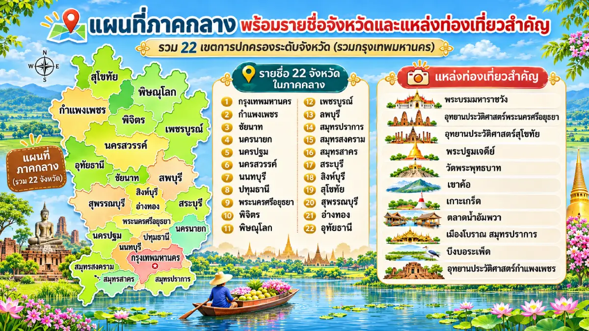
Central Thailand Map with Province Names and Major Tourist Attractions is a comprehensive guide to understanding the locations, geographical characteristics, administrative boundaries, and important tourist destinations of Central Thailand. Under the six-region geographical classification established by Thailand's National Geographical Committee, Central Thailand comprises 21 provinces and Bangkok, making a total of 22 province-level administrative areas. The region stretches from Sukhothai, Phitsanulok, Kamphaeng Phet, and Phetchabun in the upper central area, through the Chao Phraya River Basin and the historic city of Ayutthaya, to Bangkok and the river-mouth provinces bordering the Gulf of Thailand. Central Thailand is exceptionally important to the country's history, politics, economy, agriculture, transportation, and tourism. Its major attractions range from the Grand Palace, Sukhothai Historical Park, Ayutthaya Historical Park, Phra Pathom Chedi, Khao Kho, Koh Kret, and Amphawa Floating Market to remarkable natural landscapes and historic communities scattered throughout the region.
Studying Central Thailand through a map reveals that the region consists of much more than rice fields and the fertile floodplains of the Chao Phraya River. It also encompasses mountains, forests, intermontane plains, major river systems, wetlands, river estuaries, and coastal landscapes. Upper Central Thailand, including Sukhothai, Kamphaeng Phet, Phitsanulok, and Phetchabun, features geographical areas connected to important mountain ranges and river basins. The central portion of the region contains extensive plains that have long supported agriculture and human settlement, while its southern portion includes major cities, canal-side communities, industrial areas, and transportation networks closely connected with Bangkok.
How Many Provinces Are in Central Thailand? Under the six-region geographical classification used in this article, Central Thailand comprises 22 province-level administrative areas: Bangkok, Kamphaeng Phet, Chai Nat, Nakhon Nayok, Nakhon Pathom, Nakhon Sawan, Nonthaburi, Pathum Thani, Phra Nakhon Si Ayutthaya, Phichit, Phitsanulok, Phetchabun, Lop Buri, Samut Prakan, Samut Songkhram, Samut Sakhon, Saraburi, Sing Buri, Sukhothai, Suphan Buri, Ang Thong, and Uthai Thani. Bangkok has a special local-government status and is not a province within Thailand's provincial administrative system. Nevertheless, it is included when describing the 22 province-level administrative areas of Central Thailand.
However, the number of provinces assigned to Central Thailand may vary depending on the regional classification system used by different organizations. Thailand has several methods of grouping provinces for purposes such as public administration, statistical reporting, economic planning, weather forecasting, and tourism promotion. For example, Sukhothai, Phitsanulok, Kamphaeng Phet, Phichit, Phetchabun, Nakhon Sawan, and Uthai Thani may appear within Northern Thailand on certain maps, although they are classified as part of Central Thailand under the geographical system adopted in this article. Clearly identifying the classification criteria is therefore essential for accurately interpreting regional maps and provincial lists.
When examining a map of Central Thailand in relation to geographical location and landscape, the region can be understood through three broad areas. Upper Central Thailand contains historic cities, mountain ranges, valleys, and major river basins. The central area is characterized by agricultural plains and longstanding communities along important waterways. Lower Central Thailand includes Bangkok, surrounding metropolitan provinces, and communities situated near river estuaries along the Gulf of Thailand. These distinctions between upper, central, and lower areas are useful for explaining geography and planning travel itineraries; they do not represent a separate official system of provincial administration.
River systems are among the most significant geographical features of Central Thailand. The Ping and Nan rivers converge at Pak Nam Pho in Nakhon Sawan Province to form the Chao Phraya River, which flows southward across the central plains before entering the Gulf of Thailand. The Yom River is another important waterway in the upper part of the region, while the Tha Chin, Pa Sak, and Mae Klong river systems are closely connected with settlements and agriculture across various provinces. For centuries, these rivers have supported human habitation, rice cultivation, transportation, commercial activities, and urban development. Their influence remains visible in the locations of historical cities, traditional markets, farming communities, and modern transportation networks.
The historical importance of Central Thailand is particularly evident in its role as the location of major political and cultural centers across different periods of Thai history. These include Sukhothai and its associated historic towns in the upper region, Ayutthaya, which became a prosperous royal capital and international trading center, and Bangkok, the present-day capital of Thailand. Evidence of these successive periods remains visible in royal palaces, Buddhist temples, stupas, prangs, city walls, archaeological monuments, and historic neighborhoods of outstanding architectural and cultural significance.
For travelers, studying provincial names alongside a map is especially useful when planning journeys through Central Thailand. It helps visitors identify neighboring provinces, understand which destinations can be combined within a single itinerary, and recognize the different types of attractions found in each area. Examples include the Sukhothai–Kamphaeng Phet–Phitsanulok historical route, a journey along the Chao Phraya River Basin from Nakhon Sawan to Ayutthaya, and a riverside cultural route connecting Bangkok, Nonthaburi, Nakhon Pathom, and Samut Songkhram. Organizing a journey around geographically connected provinces provides a more coherent travel experience than choosing destinations solely on the basis of their popularity.
Complete List of All 22 Province-Level Administrative Areas in Central Thailand, with Geographical Characteristics and Major Tourist Attractions is presented in the following table. The list consistently follows the same six-region geographical classification throughout this article.
| Province | Geographical Characteristics and Major Tourist Attractions |
| 1. Bangkok (กรุงเทพมหานคร) | Thailand's capital, located in the lower Chao Phraya River Basin. Major attractions include the Grand Palace, Wat Phra Kaew, Wat Pho, and Wat Arun. |
| 2. Kamphaeng Phet (กำแพงเพชร) | A historic city in the Ping River Basin. Major attractions include Kamphaeng Phet Historical Park, Wat Phra Kaew, Wat Phra Si Iriyabot, and Khlong Lan Waterfall. |
| 3. Chai Nat (ชัยนาท) | An agricultural province in the Chao Phraya River Basin. Important attractions include the Chao Phraya Dam, Wat Phra Borommathat Worawihan, and Chainat Bird Park. |
| 4. Nakhon Nayok (นครนายก) | Located where the central plains meet the mountains. Major attractions include Khun Dan Prakan Chon Dam, Sarika Waterfall, and Nang Rong Waterfall. |
| 5. Nakhon Pathom (นครปฐม) | A historic province with extensive agricultural areas. Important attractions include Phra Pathom Chedi, Sanam Chandra Palace, and Phutthamonthon Buddhist Park. |
| 6. Nakhon Sawan (นครสวรรค์) | Located where the Ping and Nan rivers converge. Major attractions include Pak Nam Pho, Bueng Boraphet, and Wat Khiri Wong. |
| 7. Nonthaburi (นนทบุรี) | A province of historic riverside communities near Bangkok. Major attractions include Koh Kret, Wat Chaloem Phra Kiat Worawihan, and traditional Mon pottery communities. |
| 8. Pathum Thani (ปทุมธานี) | Located in the Chao Phraya floodplain and the Rangsit canal network. Major attractions include the National Science Museum, Wat Bot, and Wat Chedi Hoi. |
| 9. Phra Nakhon Si Ayutthaya (พระนครศรีอยุธยา) | A former royal capital and UNESCO World Heritage city. Major attractions include Ayutthaya Historical Park, Wat Chaiwatthanaram, Wat Mahathat, and Wat Phra Si Sanphet. |
| 10. Phichit (พิจิตร) | An agricultural province in the Yom and Nan river basins. Major attractions include Bueng Si Fai, Wat Tha Luang, and Wat Pho Prathap Chang. |
| 11. Phitsanulok (พิษณุโลก) | A historic city on the Nan River. Major attractions include Wat Phra Si Rattana Mahathat Woramahawihan, Phu Hin Rong Kla National Park, and Namtok Chat Trakan National Park. |
| 12. Phetchabun (เพชรบูรณ์) | A mountainous province in the Pa Sak River Basin. Major attractions include Khao Kho, Phu Thap Boek, Si Thep Historical Park, and Nam Nao National Park. |
| 13. Lop Buri (ลพบุรี) | An ancient city featuring artistic and architectural heritage from several historical periods. Major attractions include Phra Prang Sam Yot, Phra Narai Ratchaniwet Palace, and Wat Phra Si Rattana Mahathat. |
| 14. Samut Prakan (สมุทรปราการ) | Located at the mouth of the Chao Phraya River along the Gulf of Thailand. Major attractions include the Ancient City, Erawan Museum, and Phra Samut Chedi. |
| 15. Samut Songkhram (สมุทรสงคราม) | A river-mouth province with historic canal-side communities in the Mae Klong River Basin. Major attractions include Amphawa Floating Market, Maeklong Railway Market, and Wat Bang Kung. |
| 16. Samut Sakhon (สมุทรสาคร) | Located at the mouth of the Tha Chin River, with traditional coastal fishing communities. Major attractions include Mahachai Market, Phanthai Norasing Shrine, and Wat Khok Kham. |
| 17. Saraburi (สระบุรี) | Situated where the central plains meet the Dong Phaya Yen mountain range. Major attractions include Wat Phra Phutthabat Ratchaworamahawihan, Namtok Chet Sao Noi National Park, and seasonal sunflower fields. |
| 18. Sing Buri (สิงห์บุรี) | A historic province along the Chao Phraya River. Major attractions include the Bang Rachan Heroes Monument, Wat Phra Non Chaksi Worawihan, and Wat Phikun Thong. |
| 19. Sukhothai (สุโขทัย) | An ancient royal capital and UNESCO World Heritage area. Major attractions include Sukhothai Historical Park, Si Satchanalai Historical Park, and Wat Si Chum. |
| 20. Suphan Buri (สุพรรณบุรี) | A historic province in the Tha Chin River Basin. Major attractions include Sam Chuk Market, Wat Pa Lelai Worawihan, and Bueng Chawak Chaloem Phra Kiat. |
| 21. Ang Thong (อ่างทอง) | An agricultural province in the Chao Phraya and Noi river basins. Major attractions include Wat Muang, Wat Khun Inthapramun, and Wat Chaiyo Worawihan. |
| 22. Uthai Thani (อุทัยธานี) | A province featuring riverside communities along the Sakae Krang River and extensive western forests. Major attractions include Wat Chantharam (Wat Tha Sung), Hup Pa Tat, and Huai Kha Khaeng Wildlife Sanctuary. |
The complete provincial list demonstrates the remarkable geographical and cultural diversity of Central Thailand under the classification used in this article. Ancient cities and major religious sites can be found in Sukhothai, Kamphaeng Phet, Phitsanulok, Ayutthaya, Lop Buri, and Bangkok. Outstanding natural attractions are located in Phetchabun, Nakhon Nayok, Nakhon Sawan, and Uthai Thani. Meanwhile, community-based tourism and traditional riverside lifestyles are particularly prominent in Nonthaburi, Nakhon Pathom, Samut Songkhram, Samut Sakhon, and several other provinces. When choosing destinations, travelers should consider provincial locations on the map, the type of attractions they wish to visit, and the convenience of transportation between destinations. This approach makes it easier to design an itinerary that fits their available time and individual interests.
Bangkok is located in the lower Chao Phraya River Basin and serves as Thailand's capital and principal center of government administration, economic activity, education, and transportation. The geography of Bangkok is closely connected with the Chao Phraya River and an extensive network of canals that historically served as the city's major transportation routes. The historic district on the Phra Nakhon side of the river is associated with the establishment of Rattanakosin as the capital in 1782, during the reign of King Rama I. Meanwhile, other parts of Bangkok have developed into major commercial districts, residential communities, and modern transportation centers. Bangkok is therefore an essential starting point for understanding the history and geography of Central Thailand.
Major tourist attractions in Bangkok include the Grand Palace, Wat Phra Si Rattana Satsadaram (Wat Phra Kaew), Wat Phra Chetuphon Wimon Mangkhalaram (Wat Pho), and Wat Arun Ratchawararam (Wat Arun). These landmarks preserve outstanding examples of Rattanakosin architecture and traditional Thai craftsmanship. Bangkok also has historic neighborhoods such as Yaowarat, Bang Lamphu, Talat Noi, and Kudi Chin, which reflect the cultural diversity created by communities of different backgrounds settling in the capital over many generations. Visitors can explore Bangkok using the BTS Skytrain, MRT, riverboats, public buses, and other forms of public transportation connecting its major attractions. However, traffic conditions and travel times should be considered carefully when planning an itinerary.

The Grand Palace, Bangkok
Kamphaeng Phet Province is located in upper Central Thailand under the geographical classification adopted in this article. The Ping River flows through the province, while mountain ranges extend along its western side. Kamphaeng Phet has considerable historical importance as an ancient city closely associated with the Sukhothai Kingdom and the Ayutthaya Kingdom. It played a particularly significant role in defending strategic territories and connecting transportation routes between the upper regions of Thailand and the Central Plains. Evidence of its former prosperity remains visible in the ancient city walls, moats, temples, and numerous archaeological structures built primarily from laterite.
One of the province's most important tourist destinations is Kamphaeng Phet Historical Park, which forms part of the UNESCO World Heritage property known as the Historic Town of Sukhothai and Associated Historic Towns. The park preserves significant monuments, including Wat Phra Kaew, Wat Phra Si Iriyabot, and Wat Chang Rob, which demonstrate the distinctive artistic traditions and urban planning of the ancient city. Kamphaeng Phet is also home to Khlong Lan National Park, a major natural attraction known for its impressive waterfall and extensive forest landscapes. Travelers can combine Kamphaeng Phet with Sukhothai and Phitsanulok on a historical itinerary to explore the relationships among important ancient cities within the same geographical area.
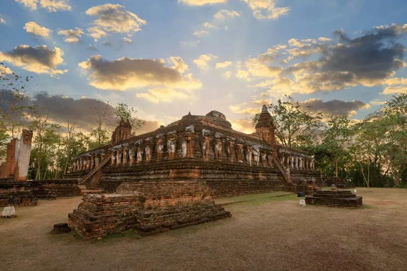
Kamphaeng Phet Historical Park, Kamphaeng Phet Province
Chai Nat Province is situated in the Chao Phraya River Basin and consists predominantly of fertile lowlands suitable for agriculture and the development of riverside settlements. The province is particularly important for water management in Central Thailand, especially because of the Chao Phraya Dam, a major irrigation structure that helps distribute water through canal networks serving agricultural areas farther downstream. The relationship between rivers, irrigation canals, and cultivated land has consequently become a defining feature of Chai Nat's economy and the everyday lives of its local communities.
Major tourist attractions in Chai Nat include Chao Phraya Dam, Wat Phra Borommathat Worawihan, and Chainat Bird Park, which provides opportunities to learn about birds and the natural environment. The province also contains traditional communities and important Buddhist temples scattered along the Chao Phraya River. Travelers interested in river basin geography and agricultural lifestyles can use Chai Nat as a convenient connection between Nakhon Sawan, Sing Buri, and Uthai Thani, following the main road networks linking these neighboring provinces.
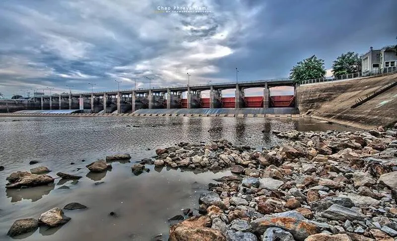
Chao Phraya Dam, Chai Nat Province
Nakhon Nayok Province is situated where the plains of Central Thailand meet the Dong Phaya Yen mountain range. Its geography is remarkably diverse, extending from agricultural land and rural communities to mountains, forests, streams, and waterfalls. The province is particularly well known for nature-based tourism because it is relatively close to Bangkok and has convenient transportation connections with Central and Eastern Thailand. As a result, Nakhon Nayok is a popular weekend destination, especially among travelers interested in waterfalls, natural scenery, and relaxing in green surroundings.
Major attractions in Nakhon Nayok include Khun Dan Prakan Chon Dam, Sarika Waterfall, Nang Rong Waterfall, and natural areas connected with Khao Yai National Park. Khun Dan Prakan Chon Dam is important both as a water resource management project and as a tourism destination. Meanwhile, nearby waterfalls and streams are especially popular when seasonal water levels are suitable for visitors. Travelers from Bangkok can reach Nakhon Nayok via Rangsit–Nakhon Nayok Road or routes connecting the province with Prachin Buri. Weather conditions and announcements concerning natural attractions should be checked before visiting, particularly during the rainy season.

Khun Dan Prakan Chon Dam, Nakhon Nayok Province
Nakhon Pathom Province is located west of Bangkok and consists mainly of low-lying plains supported by an extensive irrigation canal network connected with the Tha Chin River. The province holds exceptional historical and archaeological importance because evidence of human settlement dates back to the Dvaravati period. It also contains religious monuments associated with the historical development of Buddhism in Central Thailand. Nakhon Pathom remains an important agricultural province, particularly for fruit orchards, canal-side communities, and cultivated areas in Nakhon Chai Si and Sam Phran districts.
One of the province's most significant attractions is Wat Phra Pathom Chedi Ratchaworamahawihan, home to Phra Pathom Chedi, a monumental Buddhist stupa that serves as the most recognizable symbol of Nakhon Pathom and an important religious landmark. Other attractions include Sanam Chandra Palace, Phutthamonthon Buddhist Park, and traditional communities along the Tha Chin River, where visitors can discover distinctive local culture and cuisine. Nakhon Pathom can be reached by private car via Phet Kasem Road and other major highways. Alternatively, travelers can take a train to Nakhon Pathom Railway Station and continue by local transportation to attractions within the city.

Phra Pathom Chedi, Nakhon Pathom Province
Nakhon Sawan Province occupies an important position in the upper Chao Phraya River Basin. Its geographical significance comes from the confluence of the Ping and Nan rivers at Pak Nam Pho, where the Chao Phraya River begins its southward journey through Central Thailand. For centuries, this location has made Nakhon Sawan an important center for water transportation, commerce, and agriculture. The province is also a major transportation junction connecting Bangkok with the upper regions of the country, reinforcing its economic and geographical importance.
Major tourist attractions in Nakhon Sawan include Bueng Boraphet, one of Thailand's largest and most important freshwater wetlands, which supports a rich ecosystem and provides habitat for numerous species of waterbirds. Other notable destinations include Wat Khiri Wong, a popular viewpoint overlooking Nakhon Sawan city, and the historic Pak Nam Pho area, which has considerable cultural significance because of its longstanding Thai-Chinese communities. The province is also famous for the Pak Nam Pho Chao Pho–Chao Mae Procession, an important traditional festival that reflects the close relationships between Chinese-descended communities and this historic trading city. Travelers can use Nakhon Sawan as a starting point for exploring the Chao Phraya River Basin before continuing southward through Chai Nat, Sing Buri, and Phra Nakhon Si Ayutthaya.

Bueng Boraphet, Nakhon Sawan Province
Nonthaburi Province is located to the north and west of Bangkok, with the Chao Phraya River flowing through the province. Its history is closely connected with riverside communities that have existed for generations. Nonthaburi maintains strong relationships with Bangkok in terms of transportation, economic activity, and urban expansion. Nevertheless, several areas of the province continue to preserve traditional community cultures, particularly settlements along the river and fruit-growing areas that were once defining characteristics of Nonthaburi's landscape. These communities provide valuable insights into the historical development of settlements along the Chao Phraya River and the transformation of agricultural areas surrounding Thailand's capital.
One of Nonthaburi's most important tourist attractions is Koh Kret, a historic community in Pak Kret District that is closely associated with Mon cultural heritage. The island is particularly known for traditional pottery craftsmanship, historic Buddhist temples, and local cuisine. Visitors can explore shops and community areas that reflect traditional lifestyles along the Chao Phraya River. Other important attractions in Nonthaburi include Wat Chaloem Phra Kiat Worawihan and various religious landmarks throughout the province. Travelers can reach Nonthaburi using a combination of private vehicles, urban rail services, and passenger boats. Those planning to visit Koh Kret should check the available piers and river-crossing services before setting out.

Koh Kret, Nonthaburi Province
Pathum Thani Province is situated immediately north of Bangkok within the Chao Phraya River floodplain. The province contains an extensive network of irrigation canals, particularly around Rangsit, where the canal system played an important role in the historical development of agricultural land. Today, Pathum Thani has undergone substantial transformation into an increasingly urbanized area and an important center for education, science, technology, and industry. Despite this development, historic Buddhist temples and traditional communities can still be found along the Chao Phraya River and numerous canals throughout the province. These places preserve evidence of the agricultural and riverside lifestyles that shaped Pathum Thani before the expansion of modern urban development.
Major tourist attractions in Pathum Thani include the National Science Museum in the Khlong Ha area, an educational destination where students and families can explore scientific knowledge through exhibitions and learning activities. Other important attractions include Wat Bot, a significant Buddhist temple situated along the Chao Phraya River, and Wat Chedi Hoi, which is distinguished by its unusual stupas incorporating ancient fossilized shells. Pathum Thani is particularly suitable for family trips and educational excursions outside the classroom. Visitors traveling from Bangkok can use Phahonyothin Road or Rangsit–Nakhon Nayok Road by private car. Public transportation is another option, followed by a suitable local connection to individual attractions.

The National Science Museum, Pathum Thani Province
Phra Nakhon Si Ayutthaya Province is located within the Chao Phraya River Basin and consists largely of fertile plains shaped by several important waterways, including the Chao Phraya, Pa Sak, and Lop Buri rivers. The city of Ayutthaya served as the capital of the Ayutthaya Kingdom from 1350 to 1767 and became one of Southeast Asia's major political, commercial, and cultural centers. Its former prosperity remains visible through the historical urban layout, archaeological monuments, Buddhist temples, and artistic traditions that have survived to the present day. The geographical position of Ayutthaya, surrounded and connected by important rivers, contributed significantly to its development as a center for transportation, trade, and international cultural exchange.
Major tourist attractions include Ayutthaya Historical Park, Wat Mahathat, Wat Phra Si Sanphet, Wat Ratchaburana, and Wat Chaiwatthanaram, a magnificent historical temple featuring a prominent central prang and distinctive architecture along the Chao Phraya River. The Historic City of Ayutthaya is recognized as a UNESCO World Heritage Site for its outstanding cultural and historical significance. Travelers can reach Ayutthaya from Bangkok by private car or train, and then explore the city's major monuments using local tuk-tuks, bicycles, or sightseeing boats. Visitors who wish to experience several important archaeological sites should allow at least one full day to appreciate the historical and architectural heritage of the former royal capital.
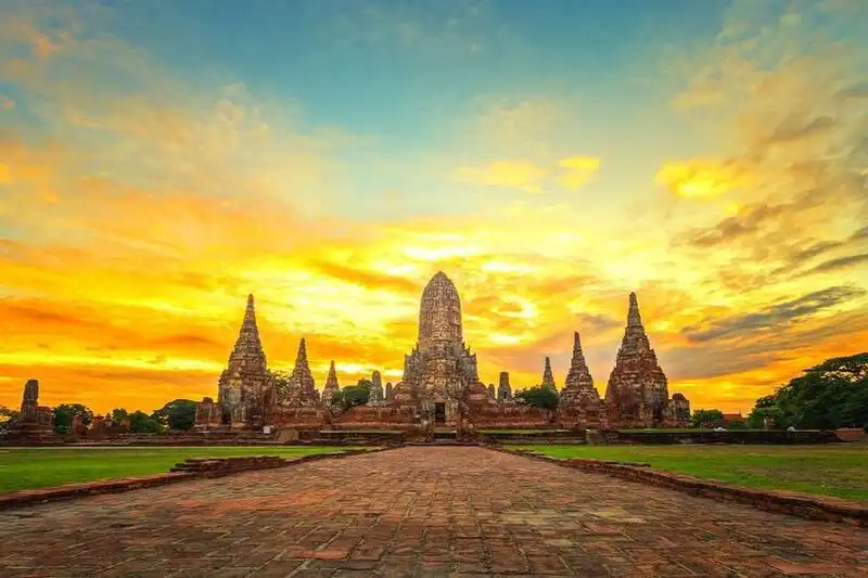
Wat Chaiwatthanaram, Phra Nakhon Si Ayutthaya Province
Phichit Province is situated in the low-lying basins of the Yom and Nan rivers. Its landscape consists mainly of agricultural land and communities whose livelihoods have been closely connected with waterways since ancient times. The province has historical associations with the old town of Phichit and settlements established throughout the river basins of upper Central Thailand. Phichit also preserves distinctive local legends and traditional stories, particularly the tale of Chalawan, the legendary crocodile character that has become closely associated with the province's identity. These stories reflect the cultural imagination of local communities and their longstanding relationships with rivers, lakes, and wetland environments.
Major tourist attractions in Phichit include Bueng Si Fai, a large freshwater lake and important recreational area for local residents and visitors. Another significant landmark is Wat Tha Luang, home to Luang Pho Phet, a highly revered Buddha image that holds considerable religious importance for the people of Phichit. Wat Pho Prathap Chang is also notable for its historical and architectural heritage. The province is additionally known for traditional longboat racing festivals, which illustrate the close relationships between riverside communities and their waterways. Travelers can combine Phichit with Phitsanulok and Nakhon Sawan to explore the geographical and cultural connections among the river basins of upper Central Thailand.

Bueng Si Fai, Phichit Province
Phitsanulok Province is an important historic city in the Nan River Basin, with strong historical connections to both the Sukhothai Kingdom and the Ayutthaya Kingdom. The province also serves as a major transportation center linking the upper regions of Thailand with Central Thailand. Its geographical characteristics range from fertile river plains to mountain ranges and forests in the eastern and northern parts of the province. This diverse landscape provides Phitsanulok with a combination of historic towns, important Buddhist temples, and natural attractions suitable for different styles of travel. Its geographical position and historical significance make the province an important destination for understanding the development of communities and transportation routes in upper Central Thailand.
One of the province's most important tourist attractions is Wat Phra Si Rattana Mahathat Woramahawihan, commonly known as Wat Yai, which houses Phra Phuttha Chinnarat, one of Thailand's most revered Buddha images. Other major attractions include Phu Hin Rong Kla National Park, known for its distinctive mountain landscapes and political history, and Namtok Chat Trakan National Park, which offers beautiful natural scenery and waterfalls. Phitsanulok can be reached by private car, train, or airplane, making it a convenient transportation center for visitors exploring upper Central Thailand. Travelers can also combine Phitsanulok with Sukhothai, Phetchabun, and Phichit. Those planning to visit national parks and mountainous destinations should allow additional travel time for winding roads and changing geographical conditions.
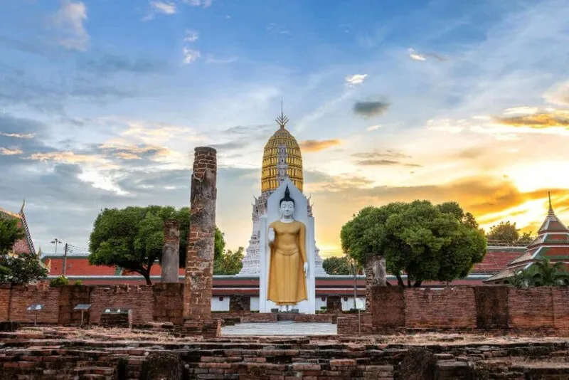
Wat Phra Si Rattana Mahathat Woramahawihan, Phitsanulok Province
Phetchabun Province is located in the upper part of Central Thailand under the six-region geographical classification used in this article. The province is distinguished by its mountain ranges and valleys, with the Pa Sak River serving as an important waterway flowing through the area. These geographical characteristics make Phetchabun noticeably different from the low-lying provinces of lower Central Thailand. This is particularly evident in Khao Kho, Lom Kao, and Nam Nao districts, where mountains, forests, and seasonal temperatures cooler than those of the central plains create a distinctive natural environment. Phetchabun is therefore an important destination for mountain tourism, historical exploration, and agricultural activities, offering visitors experiences that differ considerably from those found in the more densely populated lowlands.
One of the province's most famous tourist destinations is Khao Kho, located in Khao Kho District. The area is characterized by a series of mountain ranges and valleys that create spectacular landscapes, particularly the celebrated sea of mist that can appear during the early morning when weather conditions are favorable. The name Khao Kho is associated with the Kho palm trees that once grew abundantly in the area. Today, Khao Kho is a popular mountain retreat with numerous viewpoints, accommodation options, and tourist attractions scattered throughout the surrounding hills. Visitors can admire expansive views of the valleys and agricultural landscapes while experiencing a natural atmosphere that changes with the seasons.
Important attractions in and around Khao Kho include Khao Takhian Ngo Viewpoint, the Khao Kho Memorial, Si Dit Waterfall, and Wat Phra That Pha Sorn Kaew, a Buddhist temple in Khao Kho District renowned for its distinctive architecture and dramatic mountain setting. Phetchabun is also home to Phu Thap Boek in Lom Kao District, a high-altitude destination famous for its mountain panoramas and cool-climate agriculture, particularly the cabbage fields cultivated on the surrounding slopes. Travelers planning to visit these locations should check weather conditions, mountain roads, and seasonal travel considerations before departure. Appropriate preparation is especially important when visiting elevated areas where visibility and driving conditions can change rapidly.
Phetchabun also holds exceptional historical significance because of Si Thep Historical Park, located in Si Thep District. The site was inscribed on the UNESCO World Heritage List in 2023, recognizing the outstanding cultural importance of the ancient town of Si Thep and its associated monuments. The archaeological remains reveal evidence of ancient settlement, artistic traditions associated with Dvaravati culture, and the historical development of religious beliefs in the territory of present-day Thailand. The historical park contains numerous monuments and archaeological discoveries that demonstrate the importance of the ancient city. Travelers interested in history can combine a visit to Si Thep with Phetchabun's natural attractions, allowing them to experience the province through both its cultural heritage and its remarkable landscapes.
Travelers can reach Phetchabun by car via Highway 21, an important road connecting the lower regions of Thailand with the provincial center, or by using routes linking Phetchabun with Phitsanulok and neighboring provinces. Those planning to explore Khao Kho and Phu Thap Boek should organize their journeys according to the locations of individual attractions, as mountain destinations are spread across different areas and certain sections of the roads involve steep gradients or numerous curves. Visitors wishing to experience both Phetchabun's natural landscapes and the ancient city of Si Thep should allow several days for their trip rather than arranging an overly demanding schedule.

Khao Kho, Phetchabun Province
Lop Buri Province is one of Central Thailand's most important historical provinces, situated in an area of lowland plains connected to mountain ranges in the east. Archaeological evidence indicates that the region has been inhabited since ancient times, and it once formed the center of Lavo, a historic city associated with Dvaravati culture and the influence of Khmer civilization. Lop Buri later played an important role during the Ayutthaya period, particularly under King Narai the Great, who used the city as a royal residence and an administrative center during certain periods of his reign. This resulted in the construction of royal palaces, religious monuments, and buildings reflecting contact with foreign communities during that era.
One of the province's most significant tourist attractions is Phra Prang Sam Yot, located in Lop Buri Old Town, Tha Hin Subdistrict, Mueang Lop Buri District. The ancient monument consists of three prangs arranged in a row, constructed primarily from laterite and featuring surviving traces of decorative stucco. Its architectural characteristics reflect the Khmer Bayon style, associated with the historical development of Lavo. Phra Prang Sam Yot therefore serves as important archaeological evidence of the religious, artistic, and political relationships that shaped Central Thailand before the Ayutthaya period.
Phra Prang Sam Yot is also widely recognized for the monkeys that inhabit the surrounding area of Lop Buri Old Town. Nevertheless, the monument's principal significance lies in its architecture and archaeological importance. Visitors should take time to examine the details of the prangs, the layout of the historic structures, and the traces of religious transformation that occurred across different periods. They should also follow instructions from local authorities regarding access to the site and appropriate behavior around the animals. Feeding or attempting to touch monkeys without authorization should be avoided, both for personal safety and to respect the management of the area.
Other important attractions in Lop Buri include Phra Narai Ratchaniwet, also known as King Narai's Palace, which was constructed during the reign of King Narai the Great; Wat Phra Si Rattana Mahathat, an important temple complex containing monuments from several historical periods; San Phra Kan Shrine; and Baan Wichayen, a historic site associated with diplomatic and cultural contact between Siam and foreign communities during the Ayutthaya era. The province also offers natural attractions and sunflower fields that become popular during the flowering season. These destinations make Lop Buri an appealing combination of historical monuments, cultural heritage, and agricultural landscapes.
Travelers can reach Lop Buri by car using the major highways connecting the province with Bangkok, or by traveling on the Northern Railway Line, which serves the Lop Buri area. Many important monuments in the historic town are situated relatively close to one another, making it possible to plan a connected sightseeing route between Phra Prang Sam Yot, San Phra Kan Shrine, Wat Phra Si Rattana Mahathat, and King Narai's Palace without traveling long distances. Visitors with a particular interest in history should allow at least half a day to one full day to explore the old town and its associated museums.
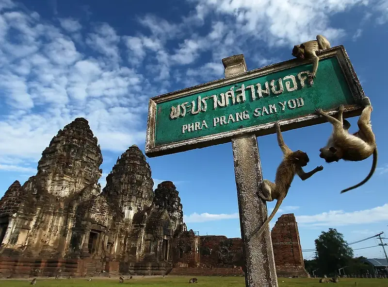
Phra Prang Sam Yot, Lop Buri Province
Samut Prakan Province is located at the mouth of the Chao Phraya River, where the river flows into the Gulf of Thailand. The province has long played an important role in transportation, commerce, industry, and the history of national defense. Historically, the Chao Phraya estuary formed a major route for merchant vessels and seagoing ships traveling toward Bangkok and other important cities in the Chao Phraya River Basin. Fortifications, religious monuments, and communities associated with maritime activities were consequently established throughout the area. In modern times, Samut Prakan has developed into a major economic and industrial center closely connected with Bangkok and is also home to Suvarnabhumi Airport.
One of the province's most important tourist attractions is Ancient Siam, also known as Muang Boran or the Ancient City, located in Bang Pu Mai Subdistrict, Mueang Samut Prakan District. This extensive open-air museum brings together architectural styles and artistic traditions from different regions of Thailand within a single site. Its distinctive character comes from the presentation of replicas, newly constructed buildings, restored structures, and architectural elements inspired by important landmarks across the country. These exhibits allow visitors to learn about Thai history, architecture, art, and culture through a carefully designed cultural landscape.
Within Ancient Siam, visitors can explore exhibits inspired by royal palaces, Buddhist temples, traditional pavilions, regional buildings, and important archaeological monuments from throughout Thailand. The overall arrangement of these attractions helps visitors understand the architectural differences between the country's various regions and compare craftsmanship associated with different historical periods. Ancient Siam is therefore particularly suitable for students, families, and international travelers wishing to develop an accessible understanding of Thailand's cultural heritage. However, visitors should distinguish between the replicas and reconstructed features displayed inside the museum and the original historical monuments located in their respective provinces.
Other notable tourist attractions in Samut Prakan include the Erawan Museum, famous for its enormous three-headed elephant sculpture; Phra Samut Chedi, an important Buddhist landmark near the mouth of the Chao Phraya River; Phra Chulachomklao Fort, which is associated with the history of Thailand's coastal defense; and Bang Pu Recreation Center, a well-known coastal leisure destination where visitors can observe nature and seasonal seagull populations. Samut Prakan consequently offers opportunities to explore Thai art, architecture, historical events, and the coastal ecosystems of the Gulf of Thailand within the same province.
Visitors traveling from Bangkok to Samut Prakan can use private cars via Sukhumvit Road and other major roads connecting Bang Na with Mueang Samut Prakan. Alternatively, travelers can take the BTS Sukhumvit Line to an appropriate station and continue by local transportation to individual attractions. Ancient Siam is situated along Sukhumvit Road in the Bang Pu area and covers a substantial area, so visitors should allocate sufficient time to explore its different sections. It is also advisable to check available activities and transportation services within the museum before traveling. Those planning a full-day itinerary can combine the Erawan Museum, Ancient Siam, and Bang Pu Recreation Center into one connected sightseeing route.

Ancient Siam (Muang Boran), Samut Prakan Province
Samut Songkhram Province is relatively small in area but possesses a remarkably distinctive geographical and cultural identity. It is located at the mouth of the Mae Klong River, where the river flows into the Gulf of Thailand. An interconnected network of rivers and natural canals has supported the development of riverside settlements, coconut plantations, fruit orchards, and agricultural land closely adapted to local soil and water conditions for generations. The traditional livelihoods of Samut Songkhram's residents have therefore been associated with boat transportation, waterborne commerce, fishing, coconut sugar production, and the use of natural resources found around the river estuary. The province provides an outstanding example of how communities in Central Thailand have developed around rivers and canals that remain central to everyday life.
One of Thailand's most famous tourist attractions is Amphawa Floating Market, located in Amphawa Subdistrict, Amphawa District. This historic canal-side market preserves the charming atmosphere of traditional wooden houses, local shops, and longstanding riverside communities. Its distinctive appeal comes from the combination of land-based trading and the sale of food and other products from boats operating along the canal. Visitors can stroll past historic buildings, sample local dishes, purchase souvenirs, and experience traditional community life closely connected with Amphawa Canal and the Mae Klong River. The market is especially well known for its lively atmosphere from the afternoon into the evening on weekends, when the canal-side area becomes a popular gathering place for visitors and local residents.
The appeal of Amphawa Floating Market extends well beyond shopping for food and souvenirs. Its deeper cultural significance lies in the history of a community that once served as an important center of waterborne commerce and has subsequently been conserved and revitalized to allow traditional community life to coexist with tourism. Historic wooden houses, canal-side shophouses, Chinese shrines, Buddhist temples, and commercial areas reflect the cultural diversity of settlements that developed through the interconnected waterways. Travelers interested in cultural heritage can explore the market at a leisurely pace to appreciate its architecture and traditional lifestyles. Depending on available services, visitors may also join boat excursions to observe local communities and natural scenery along the river.
Nearby attractions that can be included in the same itinerary as Amphawa Floating Market include King Rama II Memorial Park, also known as the King Rama II Memorial Museum and Park; Wat Amphawan Chetiyaram Worawihan; Wat Bang Kung; and the Amphawa Chaipattananurak Project. In the town of Samut Songkhram, visitors can also explore Maeklong Railway Market, famous for its trading stalls situated beside an active railway line and the remarkable sight of vendors moving their awnings and merchandise when trains pass through. The province is also renowned for local food and agricultural products, particularly Pla Thu Mae Klong, or Mae Klong short mackerel, coconut sugar, seafood, and traditional Thai desserts made with ingredients from local coconut plantations.
Travelers from Bangkok can reach Samut Songkhram via Rama II Road, also known as Highway 35, before continuing along roads connecting Amphawa District with the surrounding canal communities. Visitors planning to explore Amphawa Floating Market should check its operating days, which are primarily Friday through Sunday, and consider arriving in the afternoon to allow sufficient time to experience the market before evening. Those wishing to visit both Maeklong Railway Market and Amphawa Floating Market on the same day can begin in central Mae Klong and continue to Amphawa afterward. This itinerary provides an opportunity to experience both the atmosphere of a historic market town and the distinctive cultural environment of a traditional canal-side community.

Amphawa Floating Market, Samut Songkhram Province
Samut Sakhon Province is located at the mouth of the Tha Chin River, where the river enters the Gulf of Thailand. The province is an important center for fishing, aquaculture, seafood processing, transportation, and industrial activities. Its landscape consists of low-lying coastal plains, rivers, canals, and areas influenced by tidal movements. These environmental characteristics have shaped traditional communities whose livelihoods have long depended on fishing, salt farming, and waterborne commerce. Today, Samut Sakhon remains a major distribution center for seafood and agricultural products, maintaining strong economic connections with Bangkok and neighboring provinces.
One of the province's most important tourist attractions is Mahachai Market, situated along the Tha Chin River in the Samut Sakhon municipality. The market is particularly famous for its fresh seafood and processed marine products, with numerous shops, market stalls, piers, and urban communities contributing to its lively commercial atmosphere. Visitors exploring the market can learn about the trade and distribution of fishery products, river transportation, and the everyday lives of the people who work in this historic port town. Mahachai Market also provides a valuable perspective on the economic importance of coastal communities in lower Central Thailand and their continuing connections with the fishing industry.
Near Mahachai Market, a passenger ferry pier connects the town with Tha Chalom, a historic community situated on the opposite bank of the Tha Chin River. Tha Chalom has played an important role in waterborne trade and fishing for generations. Crossing the river by ferry therefore provides an excellent opportunity to observe the relationships between communities on both sides of the waterway. Mahachai Railway Station is also located nearby, allowing visitors to experience three interconnected forms of transportation within a relatively compact area: road, rail, and river travel. This combination reflects the longstanding importance of transportation and commercial activities to the development of Samut Sakhon.
Other important tourist attractions in Samut Sakhon include Phanthai Norasing Shrine, which is associated with the historical story of loyalty and adherence to royal law during the Ayutthaya period; Wat Khok Kham, a Buddhist temple of historical significance; and coastal communities where fishing and traditional sea salt production remain part of local livelihoods. Samut Sakhon is therefore particularly suitable for travelers interested in community history, river basin heritage, and food culture. The province offers opportunities to understand how the Tha Chin River and the Gulf of Thailand have influenced local settlement patterns, economic activities, and everyday life over many generations.
Visitors can reach Mahachai Market by private car via Rama II Road or by taking the Wongwian Yai–Mahachai railway service, a popular option for travelers wishing to experience a traditional local train journey. From Mahachai Railway Station, visitors can walk to the market and nearby ferry piers. Morning is generally a suitable time to explore the market because seafood trading activities are particularly lively during the earlier part of the day. Travelers wishing to visit the historic Tha Chalom community can take the passenger ferry across the river and continue exploring the neighborhood and its historical landmarks on foot.

Mahachai Market, Samut Sakhon Province
Saraburi Province is situated where the plains of Central Thailand meet the mountain ranges to the east. Its landscape includes the lowlands of the Pa Sak River Basin, limestone mountains, and forested areas associated with the Dong Phaya Yen mountain system. Saraburi has considerable importance as a transportation center because it connects Bangkok with upper Central Thailand and Northeastern Thailand. The province also contains major industrial areas, agricultural communities, and important Buddhist religious sites associated with the history and spiritual traditions of the Thai people. This combination of geographical features and human activities gives Saraburi a distinctive role within the wider Central Thailand region.
One of the province's most significant tourist attractions is Wat Phra Phutthabat Ratchaworamahawihan, located in Khun Khlon Subdistrict, Phra Phutthabat District. This important royal Buddhist temple is among Thailand's most revered religious destinations because it enshrines a sacred footprint believed by devotees to be that of the Buddha. According to the historical traditions associated with the temple, the discovery of the sacred footprint took place during the reign of King Songtham of the Ayutthaya Kingdom. The discovery led to the establishment of religious structures intended to enshrine and protect the footprint, which subsequently became an important object of Buddhist veneration and pilgrimage.
Wat Phra Phutthabat Ratchaworamahawihan contains architecture and religious art that reflect the devotion of Buddhist communities across several historical periods. Particularly important is the mondop, an elaborately designed religious pavilion housing the sacred Buddha's footprint, together with architectural features associated with royal religious ceremonies and traditional pilgrimage practices. The temple is also renowned for its annual Phra Phutthabat worship festival, a longstanding religious tradition that continues to hold great cultural significance. Visitors can explore the relationships among Ayutthaya history, Buddhism, and the development of communities surrounding the temple through its religious buildings, historical setting, and preserved traditions.
Beyond Wat Phra Phutthabat, Saraburi offers several important natural attractions. These include Namtok Chet Sao Noi National Park, which features a picturesque stream and a series of cascading waterfalls surrounded by natural scenery, and Muak Lek Waterfall. The areas around Muak Lek and Kaeng Khoi districts also offer mountain landscapes and outdoor destinations associated with the Dong Phaya Yen range. Saraburi is additionally known for its sunflower fields, which become popular attractions in certain agricultural areas during the planting and flowering season. As a result, the province appeals to travelers interested in religious heritage, natural scenery, and agricultural tourism.
Travelers can reach Saraburi from Bangkok via Phahonyothin Road or other major highways connecting the capital with the province. From central Saraburi, visitors can continue to Phra Phutthabat District to pay respects at the sacred Buddha's footprint or head toward Muak Lek District for nature-based activities. Those planning a Buddhist pilgrimage should allow sufficient time to explore the mondop and other important religious buildings, dress respectfully, and follow temple regulations. Visitors traveling to waterfalls should check weather conditions and the relevant national park regulations before setting out, particularly when seasonal rainfall may affect water levels and access to natural areas.

Wat Phra Phutthabat Ratchaworamahawihan, Saraburi Province
Sing Buri Province is located in the Chao Phraya River floodplain of Central Thailand. Its landscape consists mainly of agricultural land and communities that have maintained close relationships with the Chao Phraya and Noi rivers for generations. The province holds considerable historical significance because of the roles played by its towns and communities during the Ayutthaya period. In particular, Sing Buri is closely associated with the story of the villagers of Bang Rachan, who joined forces to resist the Burmese army before the second fall of Ayutthaya in 1767. Their resistance has become an important part of Thailand's historical memory and remains central to the cultural identity of Sing Buri Province today.
One of the province's most important historical attractions is the Bang Rachan Heroes Monument and Khai Bang Rachan Historical Park, located in Khai Bang Rachan District. The site was established to commemorate the villagers of Bang Rachan and their leaders, who played significant roles in the historical events surrounding the final years of the Ayutthaya Kingdom. The area contains a monument honoring the heroes, a reconstructed defensive camp, recreational spaces, and historical learning facilities that help visitors understand the courage, sacrifice, and solidarity demonstrated by local communities during this period of conflict.
The Bang Rachan Heroes Monument was created to honor the leaders and villagers who joined together to defend their community against invading forces. The surrounding historical park has been developed as a destination for historical education and public recreation. Visitors can explore exhibits presenting the story of the Bang Rachan camp and learn about the involvement of local communities in the conflicts that took place toward the end of the Ayutthaya period. Experiencing these historical settings firsthand provides a clearer understanding of how local events and community experiences are connected with the broader history of Thailand. The site also serves as a place of remembrance for the courage and determination associated with the Bang Rachan villagers.
Sing Buri is also home to several important Buddhist temples and cultural attractions. These include Wat Phra Non Chaksi Worawihan, which houses a large reclining Buddha image; Wat Phikun Thong, known for its important Buddha image; and Wat Pho Kao Ton, a temple closely associated with the historical story of the Bang Rachan camp. The province also preserves food traditions and community lifestyles shaped by the Chao Phraya and Noi river basins. Traditional handicrafts and local knowledge provide further evidence of how communities in Central Thailand have developed over time. Together, these attractions make Sing Buri an interesting destination for travelers who wish to explore Thai history, religious heritage, and the cultural traditions of agricultural communities.
Travelers can reach Sing Buri from Bangkok and neighboring provinces via the Asian Highway, or Highway 32. From central Sing Buri, visitors can continue toward Khai Bang Rachan District to reach the historical park and the Bang Rachan Heroes Monument. A one-day itinerary can include the monument, Wat Pho Kao Ton, and Wat Phra Non Chaksi Worawihan, allowing visitors to explore several important historical and religious sites within the province. Travelers should allocate sufficient time for the historical exhibitions and a leisurely walk around the park to gain a better understanding of the events and community stories associated with the area.

Bang Rachan Heroes Monument and Khai Bang Rachan Historical Park, Sing Buri Province
Sukhothai Province holds exceptional importance in Thai history as the location of the former center of the Sukhothai Kingdom. The province is situated within the Yom River Basin and the foothill areas to the west, where the remains of ancient cities and settlements provide evidence of historical developments in government, Buddhism, art, and water resource management. Sukhothai has strong historical connections with other ancient cities in the surrounding region, particularly Si Satchanalai and Kamphaeng Phet, which formed part of an important network of urban centers during the Sukhothai period. Studying this province therefore offers valuable insights into the early development of Thai history, cultural traditions, religious beliefs, and urban civilization.
One of the province's most significant tourist attractions is Sukhothai Historical Park, located in Mueang Kao Subdistrict, Mueang Sukhothai District. The park is an internationally important cultural heritage destination and was inscribed on the UNESCO World Heritage List in 1991 as part of the Historic Town of Sukhothai and Associated Historic Towns. The area preserves numerous archaeological monuments, including Buddhist temples, stupas, Buddha images, city walls, moats, ancient reservoirs known as traphang, and historical water management systems. Together, these features provide remarkable evidence of the prosperity of Sukhothai and the sophisticated development of its ancient urban environment.
One of the most distinctive characteristics of Sukhothai Historical Park is the arrangement of its ancient monuments within a landscape of ponds, reservoirs, and green spaces. Wat Mahathat, an important religious center within the ancient city, is particularly notable for its principal lotus-bud-shaped chedi and Buddha images that demonstrate the unique artistic traditions of the Sukhothai period. Other important monuments include Wat Si Sawai, which features three prangs; Wat Sa Si, beautifully situated within a landscape of ancient reservoirs; and Wat Traphang Ngoen, which preserves interesting examples of historic Buddhist architecture. Visitors can walk among these monuments and photograph the remarkable scenery while gaining a clearer impression of how the ancient city may have appeared during its period of prosperity.
Outside the ancient city walls, visitors can explore Wat Si Chum, which houses Phra Achana, a monumental seated Buddha image in the Maravijaya posture enclosed within a mandapa. Other significant monuments include Wat Phra Phai Luang and Wat Saphan Hin, both of which provide valuable evidence of the historical development of Sukhothai. Another noteworthy attraction is the ancient Saritphong Dam, which is associated with the city's historical water management system and demonstrates how early communities developed practical knowledge for managing natural resources. A visit to Sukhothai Historical Park therefore offers much more than the opportunity to admire ancient temples and stupas. It also allows travelers to explore urban planning, religious beliefs, engineering knowledge, and the relationship between human settlement and the natural environment.
Sukhothai Province is also home to Si Satchanalai Historical Park, which contains numerous ancient monuments distributed throughout the historic city and forms another part of the same UNESCO World Heritage property. The province additionally offers learning opportunities associated with traditional Sangkhalok ceramics and local handicrafts, which reflect the remarkable craftsmanship of artisans in earlier periods. Travelers interested in Thai history can organize a Sukhothai–Si Satchanalai–Kamphaeng Phet itinerary to explore the historical relationships among these important cities and gain a more comprehensive understanding of their shared artistic and cultural traditions.
Travelers can reach Sukhothai Historical Park from central Sukhothai by following Highway 12 west toward Mueang Kao Subdistrict, a distance of approximately 12 kilometers. Transportation options include private cars, hired vehicles, and local public transport services. Once inside the historical park, visitors can explore different sections on foot, by bicycle, or using sightseeing transportation where available. Those wishing to examine the principal monuments in detail should allow at least half a day. Visitors planning to explore archaeological sites both inside and outside the ancient city walls should reserve a full day for their trip. Drinking water and sun protection are also recommended because much of the sightseeing takes place outdoors.
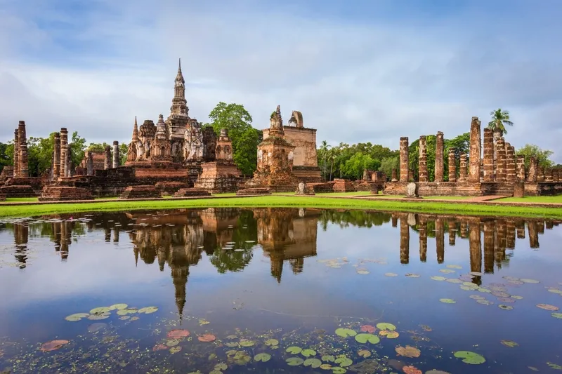
Sukhothai Historical Park, Sukhothai Province
Suphan Buri Province is located in the Tha Chin River Basin of Central Thailand, where much of the landscape consists of fertile plains suitable for agriculture. The Tha Chin River has long served as an important transportation route and has strongly influenced the establishment of settlements and commercial communities throughout the province. Suphan Buri has historical connections with ancient towns and communities dating back to the Ayutthaya period. The province also possesses a rich cultural heritage associated with Thai literature, particularly the famous story of Khun Chang Khun Phaen, in which several locations and traditional narratives are linked to the area. Today, Suphan Buri remains an important agricultural province and an appealing destination for visitors interested in local culture and historical tourism.
One of the province's most famous tourist attractions is Sam Chuk Market, also known as the 100-Year-Old Riverside Market, located in Sam Chuk District along the Tha Chin River. This historic commercial community is particularly notable for preserving the atmosphere of traditional wooden buildings, longstanding shops, and riverside market life. In the past, the Tha Chin River was an important transportation and commercial route used to move agricultural products and other goods between communities. As a result, riverside settlements developed into major trading centers serving farmers and surrounding villages. Sam Chuk Market therefore represents an important part of Central Thailand's cultural heritage and provides valuable evidence of the historical role of river transportation and commerce.
The charm of Sam Chuk Market lies in its historic market lanes, traditional wooden houses, old-fashioned coffee shops, local food vendors, and community museums that preserve the stories of the area. One particularly important attraction is the Khun Chamnong Chinrak House Museum, which offers opportunities to learn about the history of local commerce and everyday life in the market. Visitors can admire the architecture of traditional wooden buildings, speak with shop owners, sample regional dishes and Thai desserts, and explore the Thai-Chinese cultural influences that have contributed to the community's development over many generations. These experiences provide a deeper understanding of the market as a living cultural landscape rather than simply a shopping destination.
Beyond Sam Chuk Market, Suphan Buri offers several other important attractions. These include Wat Pa Lelai Worawihan, a historic Buddhist temple housing the revered Luang Pho To Buddha image; Suphan Buri National Museum; Don Chedi Monument; and Bueng Chawak Chaloem Phra Kiat, a recreational destination offering opportunities to learn about nature. The province also contains agricultural communities and cultural attractions that can be combined into connected sightseeing itineraries, particularly routes featuring traditional markets, important Buddhist temples, and educational destinations suitable for families.
Travelers from Bangkok can reach Sam Chuk Market via Highway 340, passing through the Bang Bua Thong area and central Suphan Buri before continuing north toward Sam Chuk District. The market is situated along the Tha Chin River near the Sam Chuk District Office. Visitors traveling from central Suphan Buri can follow the same highway northward. A visit to Sam Chuk Market should include enough time to explore the historic wooden buildings, community museums, and traditional shops. The morning and early afternoon are generally suitable periods for leisurely sightseeing and sampling local dishes in the market's distinctive historical surroundings.
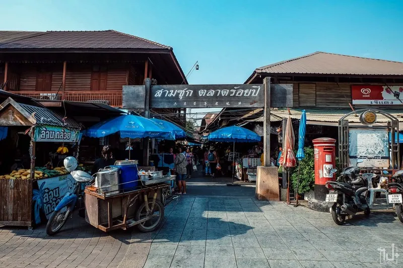
Sam Chuk 100-Year-Old Riverside Market, Suphan Buri Province
Ang Thong Province is situated within the fertile floodplains of the Chao Phraya and Noi rivers, where the geographical environment has long supported agriculture and the development of riverside communities. The province is historically significant for its Buddhist religious heritage, traditional craftsmanship, and cultural traditions. Numerous ancient temples and highly revered religious sites are distributed throughout the area. Local communities have maintained close relationships with rice cultivation, fruit growing, commercial activities, and traditional skills passed down through successive generations. Ang Thong therefore provides an excellent example of the agricultural society and cultural traditions that have characterized Central Thailand for centuries.
One of the province's most important tourist attractions is Wat Muang, located in Wiset Chai Chan District. The temple is particularly famous for its enormous golden seated Buddha image in the Maravijaya posture, commonly known as Luang Pho Yai. The image bears the formal name Phra Phuttha Maha Nawamin Sakayamuni Si Wiset Chai Chan and has become one of the most recognizable religious landmarks in Ang Thong. Its impressive dimensions make it visible from a considerable distance, attracting Buddhists and visitors who come to pay their respects, make merit, and admire the religious art and architecture within the temple grounds.
Wat Muang also contains areas displaying Buddhist teachings and moral concepts through sculptures and various religious structures. These artistic features provide visitors with opportunities to learn about Buddhist beliefs and traditional religious interpretations. In addition to paying respects to Luang Pho Yai, visitors can explore the temple grounds and study the symbolism of the Buddhist art displayed throughout the complex. Appropriate dress and respectful behavior are recommended, as Wat Muang is an important place of worship and a spiritual center for Buddhist devotees.
Ang Thong Province is also home to several other important Buddhist temples. Wat Khun Inthapramun is particularly notable for its large reclining Buddha image, while Wat Chaiyo Worawihan has strong historical associations with Buddhism in Thailand. Wat Pa Mok Worawihan is another historic temple located along the Chao Phraya River. Beyond its religious attractions, the province also preserves traditional handicraft communities known for skills such as drum making and basket weaving. These local industries reflect the craftsmanship and cultural knowledge of residents who have maintained their traditional occupations over generations. Ang Thong is therefore especially suitable for travelers interested in Buddhist pilgrimages, religious art, historic temples, and traditional community craftsmanship.
Travelers can reach Ang Thong from Bangkok by following Highway 32 through Phra Nakhon Si Ayutthaya Province before continuing into Ang Thong. Those wishing to visit Wat Muang can take the roads connecting the provincial area with Wiset Chai Chan District. Visitors planning to explore several temples should organize their itinerary according to the geographical locations of individual attractions. A convenient pilgrimage route can connect Wat Muang with Wat Khun Inthapramun, Wat Chaiyo Worawihan, and other important religious sites. Sufficient time should be allocated for exploring temple grounds, appreciating religious architecture, and participating in Buddhist activities where appropriate.
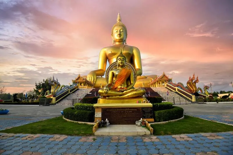
Wat Muang, Ang Thong Province
Uthai Thani Province is located in the upper part of Central Thailand under the geographical classification used in this article. Its landscape is remarkably diverse, encompassing the low-lying Sakae Krang River Basin and the forested mountains extending across the western part of the province. Uthai Thani is important for both the historical development of riverside communities and the conservation of natural resources, particularly its western forest areas, which form part of one of Thailand's extensive protected forest landscapes. The traditional lifestyles of Uthai Thani's residents have long been connected with the Sakae Krang River through housing, commerce, freshwater fishing, and water transportation. These activities have contributed to the development of distinctive riverside communities, several of which continue to preserve the atmosphere and cultural character of the historic town.
One of the province's most significant tourist attractions is Wat Chantharam, commonly known as Wat Tha Sung, located in Nam Suem Subdistrict, Mueang Uthai Thani District. The temple is famous for the impressive architecture and artistic decoration of its important buildings, particularly the Glass Viharn and the Golden Castle, both of which feature elaborate decorative elements. Wat Tha Sung is also closely associated with Phra Ratchaphrommayan, widely known as Luang Pho Ruesi Ling Dam, a highly respected Buddhist monk who played an important role in developing the temple and teaching Buddhism. Through his influence and the continued devotion of Buddhist communities, Wat Tha Sung has become an important spiritual destination attracting worshippers from throughout Thailand.
One of Wat Tha Sung's most distinctive features is the interior decoration of the Glass Viharn, where numerous reflective glass surfaces create a brilliant and memorable atmosphere. Other religious buildings and architectural features within the temple complex have also been constructed with considerable attention to artistic detail. Visitors can appreciate Buddhist art, pay respects at important religious sites, and learn about the history of the temple and its connections with communities along the Sakae Krang River. However, certain areas and buildings within the temple are open to visitors only during designated periods. Travelers should therefore check the visiting schedules for individual buildings before arriving to ensure they can experience the attractions they intend to see.
Beyond Wat Tha Sung, Uthai Thani offers several other important attractions. Wat Sangkat Rattana Khiri and Khao Sakae Krang provide scenic views of the town and are associated with the traditional Tak Bat Thewo almsgiving ceremony. Natural attractions include Hup Pa Tat, an unusual forest environment enclosed within a limestone mountain, and Huai Kha Khaeng Wildlife Sanctuary, which forms part of the UNESCO World Heritage property known as Thungyai–Huai Kha Khaeng Wildlife Sanctuaries. These protected natural areas demonstrate the province's considerable geographical diversity, from forest ecosystems and mountain landscapes to rivers, agricultural lowlands, and historic communities.
Central Uthai Thani is also known for its floating-house communities and traditional residences along the Sakae Krang River. These settlements provide an enduring reflection of ways of life that have depended on waterways for many generations. Visitors can explore historic markets and community neighborhoods to learn about local history, sample traditional dishes, and experience the peaceful atmosphere of a town that continues to preserve its distinctive cultural character. Uthai Thani is therefore particularly appealing to travelers who wish to combine cultural experiences with nature-based tourism and gain a deeper understanding of how communities in upper Central Thailand have adapted to their geographical environment and river systems.
Travelers can reach Uthai Thani from Bangkok by following Highway 32 through Phra Nakhon Si Ayutthaya and Chai Nat provinces before taking the connecting road into Uthai Thani town. From the town center, visitors can continue to Wat Chantharam, or Wat Tha Sung, by private car or local hired transportation. A one-day itinerary can include Wat Tha Sung, Khao Sakae Krang, and the riverside communities of the historic town. However, visitors planning to explore Hup Pa Tat or more remote natural attractions should allocate additional time and check road conditions and the regulations governing access to protected natural areas before traveling.
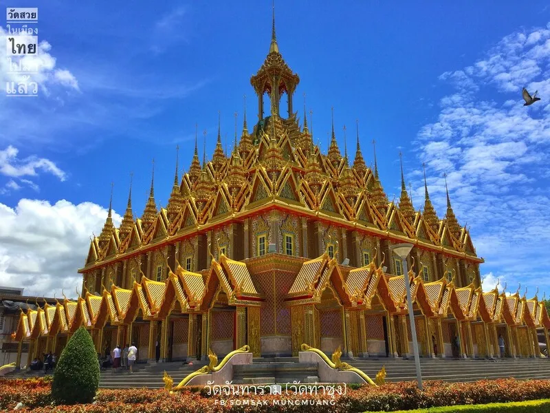
Wat Chantharam (Wat Tha Sung), Uthai Thani Province
After examining all the provinces of Central Thailand, it becomes clear that the region possesses far greater geographical and cultural diversity than the familiar image of the Chao Phraya River floodplain alone. Provinces in the upper region contain historic cities and mountain-based natural attractions, particularly Sukhothai, Kamphaeng Phet, Phitsanulok, Phetchabun, and Uthai Thani. The central portion of the region includes ancient towns, important religious sites, and agricultural communities that developed along major river systems. Meanwhile, lower Central Thailand encompasses Bangkok and neighboring provinces that play major roles in the economy, transportation, and urban culture, alongside traditional riverside and estuarine communities that continue to preserve distinctive aspects of Central Thai life.
Using a map of Central Thailand together with a complete provincial list and detailed information about major tourist attractions makes it possible to plan journeys in a more systematic and meaningful way. Travelers interested in history can select routes connecting UNESCO World Heritage cities and important archaeological monuments. Those interested in Buddhism can organize pilgrimage itineraries linking significant temples across different provinces. Nature enthusiasts can explore mountains, waterfalls, and wetlands according to seasonal conditions, while visitors interested in traditional lifestyles can discover historic markets and riverside communities that continue to preserve their cultural heritage. Planning journeys according to provincial locations and actual transportation routes helps improve travel convenience while allowing visitors to appreciate the distinctive historical, cultural, and natural value of each destination.
Frequently Asked Questions (FAQ)
Q: How many provinces are in Central Thailand, and what are their names?
A: Under the six-region geographical classification used in this article, Central Thailand consists of 21 provinces and Bangkok, making a total of 22 province-level administrative areas. These are Bangkok, Kamphaeng Phet, Chai Nat, Nakhon Nayok, Nakhon Pathom, Nakhon Sawan, Nonthaburi, Pathum Thani, Phra Nakhon Si Ayutthaya, Phichit, Phitsanulok, Phetchabun, Lop Buri, Samut Prakan, Samut Songkhram, Samut Sakhon, Saraburi, Sing Buri, Sukhothai, Suphan Buri, Ang Thong, and Uthai Thani.
Q: Why do some maps of Central Thailand show a different number of provinces?
A: Thailand uses several regional classification systems for different purposes, including geographical studies, public administration, and economic planning. As a result, provinces such as Sukhothai, Kamphaeng Phet, Phitsanulok, Phichit, Phetchabun, Nakhon Sawan, and Uthai Thani may be classified as part of Northern Thailand under other systems. However, these provinces are included in Central Thailand under the geographical classification adopted in this article.
Q: Which provinces in Central Thailand have important historical attractions?
A: Provinces particularly notable for their historical attractions include Bangkok, Phra Nakhon Si Ayutthaya, Sukhothai, Kamphaeng Phet, Lop Buri, and Phitsanulok. Important landmarks include the Grand Palace, Ayutthaya Historical Park, Sukhothai Historical Park, Kamphaeng Phet Historical Park, Phra Prang Sam Yot, and Wat Phra Si Rattana Mahathat Woramahawihan.
Q: What are some interesting natural attractions in Central Thailand?
A: Major natural attractions include Khao Kho and Phu Thap Boek in Phetchabun Province, Bueng Boraphet in Nakhon Sawan Province, Sarika Waterfall and Nang Rong Waterfall in Nakhon Nayok Province, Khlong Lan Waterfall in Kamphaeng Phet Province, and Hup Pa Tat in Uthai Thani Province. Travelers should choose suitable visiting periods according to seasonal conditions and the weather.
Q: Which provinces in Central Thailand are suitable for short trips from Bangkok?
A: Provinces suitable for short trips from Bangkok include Nonthaburi, Pathum Thani, Nakhon Pathom, Phra Nakhon Si Ayutthaya, Samut Prakan, Samut Sakhon, and Samut Songkhram. Popular attractions include Koh Kret, the National Science Museum, Phra Pathom Chedi, Wat Chaiwatthanaram, Ancient Siam, Mahachai Market, and Amphawa Floating Market.
Q: What are some famous floating markets and traditional markets in Central Thailand?
A: Well-known markets include Amphawa Floating Market in Samut Songkhram, Sam Chuk Market in Suphan Buri, and Mahachai Market in Samut Sakhon. Each has a distinctive character. Amphawa is known for its canal-side community atmosphere, Sam Chuk for its traditional wooden buildings and historic riverside trade along the Tha Chin River, and Mahachai for its seafood commerce and traditional port-town lifestyle.
Q: How should travelers plan an itinerary through Central Thailand?
A: Travelers should organize their itineraries around groups of geographically connected provinces. Examples include Bangkok–Phra Nakhon Si Ayutthaya–Lop Buri for historical tourism; Sukhothai–Kamphaeng Phet–Phitsanulok for ancient cities; Bangkok–Nakhon Pathom–Samut Songkhram for traditional riverside communities; and Phitsanulok–Phetchabun for mountain landscapes and nature-based tourism. Actual travel distances and journey times should be checked before finalizing an itinerary.
Q: How is a map of Central Thailand useful for travelers?
A: A map of Central Thailand helps travelers identify provincial locations, geographical boundaries, neighboring provinces, and connections between transportation routes. This makes it easier to organize journeys between tourist attractions efficiently. It also provides a clearer understanding of the relationships among geography, history, culture, and the traditional lifestyles of communities throughout the region.
 Category: ●Travel Articles, Recipes
 Group: ●Travel Review, Food Review
Last Update : 1 DayAgo
 Last Update : 1 DayAgo
Recommend

 Art, Culture and Heritage
 Historical Sites and Monuments(3)
 Landmarks and Memorials(23)
 Royal Palace(13)
 Art, Craft Centres, Tradition(35)
 Museums(59)
 Historic Homes and Cities(3)
 Art Gallery(16)
 Educational Places
 Museum for Study(6)
 Library(4)
 University
 Public university(8)
 Autonomous Universities(8)
 Rajamangala University of Technology(6)
 Rajabhat University(6)
 Private University(22)
 Places of Worship
 Temple(72)
 Church(2)
 Mosque(67)
 Other Sacred Sites(8)
 Research and Development
 Royal Project(1)
 Suburban Living
 Village, Community(5)
 Local Market(9)
 Floating Market(2)
 Nature and Wildlife
 River, Canal(3)
 Bays and Beaches(1)
 Other natural attractions(1)
 Entertainment and Agricultural
 Zoos and Aquariums(5)
 Animal camps and shows(5)
 Stadium(9)
 Farms, Parks and Ecotourism(20)
 Amusement Park(1)
 Waterpark(4)
 Theater(7)
 Cinema(1)
 Shopping
 Shopping and Night Market(20)
 Department Store(7)
 Spas and Wellness
 Spas and Wellness(1)
 Restaurant
 Michelin Star(5)
 Accommodation
 Hotel(3)
 Call Customer Service in Tourism
 Call Customer Service in Tourism(1)
Travel Review, Food Review(52)
 Royal Thai Desserts and Recipes(56)


