
lovethailand home >Central Travel Attractions >Bangkok Travel Attractions > Thailand Map All 77 Provinces Complete Province Li..
TL;DR: Thailand Map All 77 Provinces Complete Province List and Regional Divisions.
Thailand Map All 77 Provinces Complete Province List and Regional Divisions
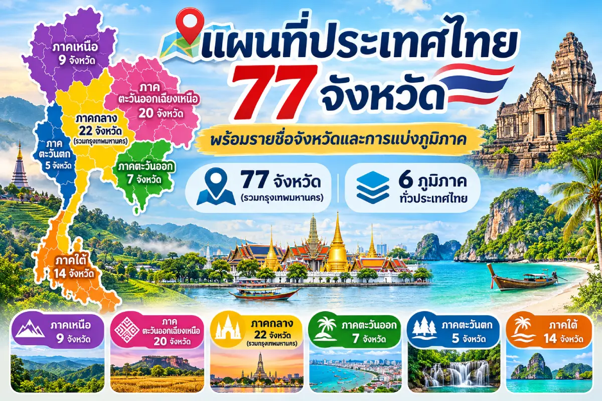
Map of Thailand: All 77 Provinces, Provincial Names and Regional Divisions provides essential information for understanding the location of Thailand's provinces, administrative boundaries, landscapes and geographical differences. Thailand comprises 76 provinces under the provincial administrative system and Bangkok, which is a special local administrative authority. Together they form 77 province-level administrative areas, giving rise to the familiar expression "Thailand's 77 provinces." Under the geographical classification used here, the country is divided into 6 regions: Northern Thailand with 9 provinces, Northeastern Thailand with 20, Central Thailand with 22 province-level areas including Bangkok, Eastern Thailand with 7 provinces, Western Thailand with 5 and Southern Thailand with 14.
Explore Thailand by Region:Northern Thailand | Northeastern Thailand (Isan) | Central Thailand | Eastern Thailand | Western Thailand | Southern Thailand
A map of Thailand does much more than locate provinces on the Earth's surface. It reveals connections among landforms, climate, natural resources, human settlement and everyday life across the country's regions. Thailand encompasses high mountain ranges, intermontane plains, river floodplains, plateaus, forests, coastlines and numerous islands. These varied environments have shaped urban development, agriculture, transportation and tourism, as well as the distinctive cultural identities of individual localities.
Thailand occupies a central position in Southeast Asia and shares land borders with 4 neighboring countries: Myanmar, Laos, Cambodia and Malaysia. The Andaman Sea lies west of the southern peninsula, while the Gulf of Thailand borders the country's eastern and southern shores. This geographical position makes Thailand an important crossroads for transportation, cross-border trade, tourism and international economic connections within the region.
Looking at Thailand's outline on a map, the broad northern portion is crossed by complex mountain ranges. The northeastern territory extends eastward as a plateau, while the central region encompasses major river plains that have long supported cities and farming communities. The east combines Gulf of Thailand coastlines with fruit-growing districts, and the west contains mountains, forests and major natural borderlands. Farther south, the country narrows into a long peninsula with seas on both sides.
Geographical differences are closely connected with local culture and ways of life. Northern Thailand has Lanna cultural heritage and valley settlements; the northeast has Isan traditions associated with the Mekong basin and Khorat Plateau; and the central region has a history of royal capitals and farming communities along the Chao Phraya River. The east includes fishing settlements and important fruit-growing areas, while western communities have longstanding ties to forests, mountains and borderlands. Southern Thailand has a distinctive peninsular culture shaped by maritime trade, religion and contact among people of diverse backgrounds.
For anyone learning the complete list of Thai provinces, studying their locations on a map alongside their regional groupings makes the names easier to remember. This is especially useful for provinces with similar names and for those near regional boundaries, such as Tak, Kamphaeng Phet, Nakhon Sawan, Phitsanulok, Phetchabun, Nakhon Nayok and Prachuap Khiri Khan. Such provinces may be assigned to different regions by different organizations. A list of provinces should therefore always be read together with the classification system on which it is based.
How many regions are there in Thailand? Under the geographical system associated with Thailand's National Geographical Committee, the country has 6 regions: North, Northeast, Central, East, West and South. Physical terrain is the primary basis for the division, supplemented by climate, culture, language and residents' ways of life. These criteria offer a systematic way to understand differences across Thailand and have been used as a framework for geographical information compiled by the Office of the Royal Society of Thailand.
Nevertheless, there is no single regional classification used for every purpose in Thailand. Government agencies and other organizations may draw boundaries to suit economic development, population statistics, public administration, natural-resource management, weather forecasting or tourism promotion. Consequently, one map may show 4 regions, another 5, and yet another 6 regions with provincial memberships that differ. All may depict the same country while applying different criteria.
Tak provides a clear example. The National Geographical Committee's geographical classification places it in Western Thailand, whereas some agencies group it with the North. Similarly, Kamphaeng Phet, Phichit, Phitsanulok, Phetchabun, Sukhothai, Nakhon Sawan and Uthai Thani are included in Central Thailand under the system followed in this article, although they appear in Northern Thailand under other systems. Such differences reflect the purpose of regional classification; they do not mean that provincial administrative borders have changed.
It is also important to distinguish between a province and Bangkok. Bangkok is routinely counted among Thailand's 77 province-level administrative areas, but legally it is a special local administrative authority. Its governing structure differs from that of an ordinary province, which is administered by a provincial governor. Strictly speaking, Thailand has 76 provinces in its provincial administrative system. Counting Bangkok brings the national total to 77 province-level administrative areas.
A major modern change to Thailand's provincial map occurred in 2011, when Bueng Kan Province was created from part of Nong Khai Province. The change brought the number of ordinary provinces to 76, or 77 province-level administrative areas with Bangkok included. Bueng Kan lies in Northeastern Thailand along the Mekong River and is important for border geography, local culture and Isan's nature-based tourism.
Learning Thai geography involves more than memorizing province names: each province's position relates to rivers, mountain ranges, coastlines and its neighbors. Chiang Mai and Chiang Rai are in the mountainous north; Nakhon Ratchasima occupies an important position at the edge of the Khorat Plateau; and Phra Nakhon Si Ayutthaya and Pathum Thani lie within the Chao Phraya basin. Chon Buri and Rayong border the Gulf of Thailand, Kanchanaburi has western mountains and river basins, and Phuket and Krabi are major destinations on the Andaman coast.
Thailand's provincial map is also useful for planning journeys because it reveals how different areas connect and helps travelers build practical multi-province routes. A northern itinerary might combine Chiang Mai, Lamphun, Lampang and Chiang Rai; an Isan route could link Nakhon Ratchasima, Khon Kaen, Udon Thani and Nong Khai. In the south, travelers can choose between the Gulf of Thailand and Andaman Sea coasts according to the season, weather conditions and time available.
A map can suggest the relative distance and direction between provinces, but straight-line map distances are not necessarily the distances traveled on the ground. Roads must navigate mountains, rivers, built-up areas and different transportation networks. Travelers should therefore combine administrative maps with road maps and public-transport information, particularly for mountain journeys in Northern and Western Thailand or long interprovincial trips in the south.
Dividing Thailand into 6 regions also helps explain the variety of its traditions. Examples include the Yi Peng festival and other Lanna customs in the north; the Bun Bang Fai Rocket Festival and monthly merit-making festivals in Isan; river-related customs of Chao Phraya communities in Central Thailand; local traditions of eastern coastal communities; ethnic and border-community cultures in the west; and Chak Phra processions and multireligious community traditions in the south. These practices reflect the connections between environment, history and people's livelihoods.
A useful approach to studying all 77 province-level areas is therefore to understand the character of each region first and then examine the provinces within it. This makes provincial geography easier to organize mentally, connects physical geography with history, culture and tourism, and turns the map of Thailand into a learning resource rather than merely a tool for locating names.
Northern Thailand has 9 provinces: Chiang Rai, Chiang Mai, Nan, Phayao, Phrae, Mae Hong Son, Lampang, Lamphun and Uttaradit. The landscape is characterized by complex high mountains, intermontane plains, forests and important river headwaters. Most of the ranges extend from north to south, concentrating major towns and communities in lowland basins and river valleys, including the Chiang Mai–Lamphun, Chiang Rai and Lampang basins and the Yom and Nan river systems. This physical setting has influenced settlement, agriculture and road development since ancient times.
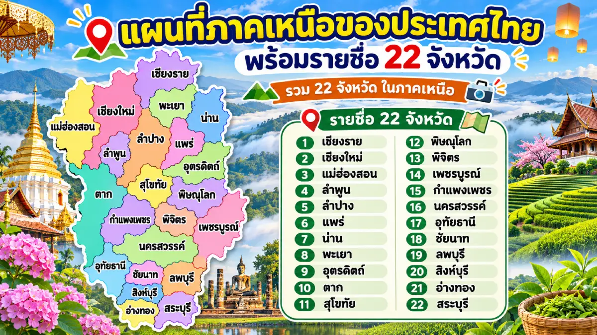
The map of Northern Thailand is historically significant because the region once contained several kingdoms and ancient cities. Among them were the Lanna Kingdom, whose major capital was Chiang Mai, Hariphunchai at Lamphun, and the historic centers of Nan, Phrae and Khelang Nakhon at Lampang. This history survives in temples, city walls and moats, archaeological remains, works of art and customs passed down to the present. Northern culture therefore has distinctive languages, music, clothing, food, handicrafts and Buddhist traditions.
Chiang Rai Province, at the northern end of Thailand, has mountain ranges, valleys and plains and shares borders with Myanmar and Laos. It includes the Golden Triangle, where Thailand, Laos and Myanmar meet. Important attractions include Wat Rong Khun, Wat Phra Kaew, Doi Tung and Phu Chi Fa. Ethnic communities add further diversity through their languages, clothing and lifestyles. The province's identity brings together Lanna history, highland nature and border cultures.
Chiang Mai Province is a major northern center of history, economy, education and tourism. King Mangrai founded Chiang Mai as the capital of the Lanna Kingdom in 1296. Important heritage sites include Wat Phra That Doi Suthep, Wat Chedi Luang and Wat Phra Singh Woramahawihan. Chiang Mai is also home to Doi Inthanon, Thailand's highest mountain, alongside forests, natural attractions, handicraft villages and well-known centers of Lanna cultural learning.
Chiang Rai and Chiang Mai share close historical and cultural ties, particularly through Lanna heritage, the Northern Thai language, traditional arts and Yi Peng, the Lanna form of Loy Krathong, during which oil lamps and lanterns illuminate temples and communities. Travelers interested in history and culture can use these 2 provinces as starting points for exploring Lanna heritage before continuing to old towns and communities in neighboring provinces.
Nan Province is predominantly mountainous and is crossed by the Nan River. Its history is closely connected with the former city-state of Nan, and its cultural identity reflects exchanges among Lanna communities, Tai Lue people and highland populations. Highlights include Wat Phumin, Wat Phra That Chae Haeng, Nan National Museum and Doi Phu Kha National Park, noted for mountain scenery and natural diversity. Nan is also known for traditional textiles, temple murals and communities that retain distinctive cultural traditions.
Phayao Province occupies a basin surrounded by mountains and is particularly known for Kwan Phayao, a large freshwater lake that supports local ecosystems and community livelihoods. Phayao has a long history and was once the center of the Phukamyao Kingdom. Notable sites include Wat Si Khom Kham, Wat Tilok Aram—with archaeological remains in the lake area—and mountain-based attractions. The province offers a combination of ancient urban history, Buddhism and lakeside community landscapes.
Phrae Province is an old town in the Yom River basin, with intermontane plains and a history of timber trading and teak logging. Its wooden buildings and historic noble residences, including Khum Wong Buri, alongside old temples and remnants of city fortifications, reflect the prosperity of Lanna communities. Phrae is also known for mo hom indigo-dyed clothing, a local craft deeply connected with everyday dress and traditions.
Mae Hong Son Province follows the Thai–Myanmar border and is distinguished by rugged mountain ranges and deep valleys. Many communities are connected by winding mountain roads. The province is home to diverse cultural and ethnic groups, including Shan communities. Attractions include Wat Phra That Doi Kong Mu, Pai District, Pang Ung and Ban Rak Thai. Mae Hong Son clearly illustrates how mountain geography shapes settlement patterns, local culture and daily life.
Lampang Province is an important town in the Wang River basin, with historical ties to Khelang Nakhon and Lanna culture. Significant sites include Wat Phra That Lampang Luang, Wat Pong Sanuk and heritage buildings in the old town. Lampang is widely associated with horse-drawn carriages and ceramics, especially its rooster-pattern bowls. Natural sites such as Chae Son National Park, with hot springs and forested mountains, add another dimension to a province where old-town heritage meets northern nature.
Lamphun Province is essential for understanding the early history of states in Northern Thailand. It is associated with the Hariphunchai Kingdom, which preceded the founding of Lanna. Important monuments include Wat Phra That Hariphunchai Woramahawihan and Wat Chamthewi, both reflecting Buddhist beliefs and historic artistic traditions. Lamphun is also a major longan-growing province with weaving communities and handicrafts that preserve local knowledge.
Uttaradit Province sits where the northern mountains meet lower plains, with the Nan River as a major waterway and a history of river ports and trade routes. Attractions include the Phraya Phichai Dap Hak Monument, Wat Phra Thaen Sila At and natural areas in Nam Pat and Tha Pla districts. The province is also renowned for Long Laplae and Lin Laplae durians, distinctive agricultural products associated with the climate and landscape of Laplae.
Northern Thailand's climate differs substantially between lowlands and highlands. During the cool season, some mountain and valley areas are colder than Central and Southern Thailand, making them popular destinations for misty scenery and chilly weather. In the rainy season, forests and farmlands turn lush green, although heavy rainfall and landslides can affect mountain routes. Visitors should check weather and road conditions, especially before traveling to highlands and national parks.
Travel within the north follows major road corridors such as Chiang Mai–Chiang Rai, Chiang Mai–Lamphun–Lampang and routes connecting Phrae, Nan, Phayao and Uttaradit. Anyone visiting several provinces should factor winding roads and realistic journey times into their plans. Destinations that look close on a map can be far apart in driving time when roads cross mountains or remote terrain. Planning by neighboring province clusters helps travelers move efficiently while appreciating changing local cultures.
In summary, Northern Thailand's 9 provinces share mountainous landscapes and Lanna cultural heritage, yet each has its own identity: Chiang Mai and Lamphun are important historic cities; Chiang Rai and Mae Hong Son have prominent border cultures; Nan, Phrae and Lampang are rich in local arts and traditions; and Phayao and Uttaradit combine river basins and mountain landscapes. This variety makes the north especially valuable for the study of geography, history and cultural tourism.
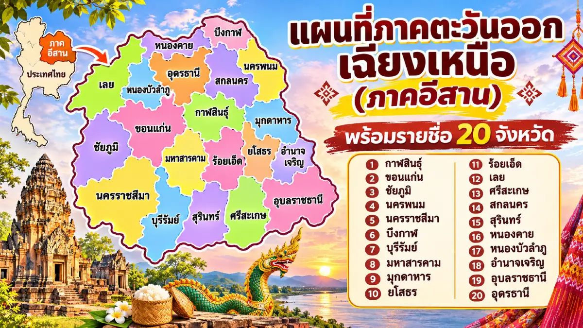
The map of Northeastern Thailand, or Isan, covers 20 provinces: Kalasin, Khon Kaen, Chaiyaphum, Nakhon Phanom, Nakhon Ratchasima, Bueng Kan, Buri Ram, Maha Sarakham, Mukdahan, Yasothon, Roi Et, Loei, Si Sa Ket, Sakon Nakhon, Surin, Nong Khai, Nong Bua Lam Phu, Amnat Charoen, Udon Thani and Ubon Ratchathani. This extensive region is dominated by the Khorat Plateau. The Phetchabun and Dong Phaya Yen ranges help mark its western edge, while the Phanom Dong Rak Range extends along its southern side near Cambodia.
Two major river systems—the Chi and Mun basins—shape Isan's agriculture and settlement patterns. The Mun River joins the Mekong in Ubon Ratchathani Province. The Mekong itself forms an important natural corridor for border provinces such as Loei, Nong Khai, Bueng Kan, Nakhon Phanom and Mukdahan. Northeastern geography is consequently closely connected with rice cultivation, livestock raising, border commerce and the way of life of riverside communities.
Nakhon Ratchasima Province, also called Korat, occupies a strategic gateway to the northeastern plateau and is important for transport, business, education and industry. Historic attractions include the Thao Suranari Monument, Phimai Historical Park and the Ban Prasat archaeological site. The province also encompasses natural areas around Khao Yai National Park and numerous agricultural attractions. It demonstrates how Isan history, modern urban development and the natural environment intersect.
Buri Ram Province is particularly rich in ancient Khmer heritage, especially the stone sanctuaries of Phanom Rung and Muang Tam, which provide important evidence of historical religion and art. The province includes lowlands and several extinct volcanic mountains, creating distinctive landforms and natural resources. Alongside these ancient sites, Buri Ram retains local traditions associated with Thai-Khmer communities and other cultural groups.
Surin Province has a distinctive identity rooted in traditional culture, silk weaving and knowledge of elephant care. In Tha Tum District, communities have maintained a longstanding relationship with elephant raising. The province also has important archaeological monuments, including Prasat Sikhoraphum, and customs reflecting the coexistence of Thai-Khmer, Kuy and Lao cultural groups. This diversity distinguishes Surin from other parts of Isan.
Si Sa Ket Province lies in the southern part of Isan along the Cambodian border. Its cultural landscape reflects communities of Thai-Lao, Thai-Khmer, Kuy and Yer heritage. Significant sites include Prasat Sa Kamphaeng Yai and Wat Maha Phuttharam. Si Sa Ket is also celebrated for its volcanic-soil durians, particularly in Kantharalak District and surrounding areas, where soils are associated with ancient volcanic formations.
Ubon Ratchathani Province is an important eastern Isan province, where the Mun and Mekong rivers are major geographical features and the land borders both Laos and Cambodia. It is famous for its Buddhist Lent Candle Festival, which expresses religious devotion through elaborate candle sculpture. Important places include Wat Phra That Nong Bua, Pha Taem National Park and Sam Phan Bok, a remarkable landscape of water-eroded rock formations along the Mekong.
Chaiyaphum Province lies where the Khorat Plateau meets mountain ranges to the west, combining agricultural plains with forested uplands. Major attractions include Pa Hin Ngam National Park, Sai Thong National Park and the Chao Pho Phaya Lae Monument. Chaiyaphum is especially known for seasonal fields of Siam tulips, or dok krachiao, which bloom in forests and grasslands. It is an excellent place to examine the relationship between plateau ecology and nature tourism.
Khon Kaen Province is a leading center of education, medicine, transportation and economic activity in Northeastern Thailand. Much of its land lies on the plateau, while its urban communities continue to grow. Landmarks include Phra Mahathat Kaen Nakhon at Wat Nong Waeng, Bueng Kaen Nakhon and Khon Kaen National Museum. The Phu Wiang area also contains important geological and dinosaur fossil sites that contribute to scientific education in Thailand.
Maha Sarakham Province lies in central Isan, where extensive plains support agriculture. The province is notable for education and regional culture, with several higher-education institutions and important archaeological and religious sites. Among these is Phra That Na Dun, closely linked with the history and beliefs of local communities. Maha Sarakham provides insights into the relationship among agrarian society, education and Northeastern Thailand's cultural heritage.
Roi Et Province contains agricultural plains and long-established urban communities, with Bueng Phlan Chai serving as a well-known lake in the city center. Notable sites include Wat Burapha Phiram and Phra Maha Chedi Chai Mongkhon. Roi Et also celebrates the Bun Phawet festival, associated with the Great Birth Sermon and Buddhist faith. Its cultural life illustrates the endurance of Isan's cycle of merit-making traditions and community customs.
Kalasin Province is particularly well known for dinosaur fossils, especially the Phu Kum Khao site in Sahatsakhan District, where the Sirindhorn Museum is located. The province is also recognized for Phu Thai culture and elaborate Phrae Wa silk weaving, notably around Kham Muang District and neighboring communities. Kalasin therefore offers opportunities to study natural history, geology and traditional textile craftsmanship in one province.
Yasothon Province consists largely of agricultural plains and has traditions closely connected with Isan's annual merit-making cycle. The most famous is the Bun Bang Fai Rocket Festival, linked with beliefs about rain and crop cultivation. Other attractions include historic communities, temples and centers of local knowledge, including traditional crafts and village products. Yasothon exemplifies the strong relationship between agricultural livelihoods and communal festivals.
Amnat Charoen Province is situated in eastern Isan and is characterized by farmland and communities that continue to practice longstanding regional traditions. An important landmark is Phra Mongkhon Ming Mueang Buddhist Park, together with village cultural sites. The province is known for handicrafts, woven fabrics and rural ways of life connected with Buddhism, farming and close local social relationships.
Udon Thani Province is a major economic and transportation center of upper Isan, linking inland Thailand with border provinces and Laos. Its internationally important archaeological site, Ban Chiang, is inscribed on the UNESCO World Heritage List. Other attractions include the Red Lotus Sea at Nong Han Kumphawapi and Wat Pa Phu Kon. Together they illustrate the province's variety of archaeological, religious and nature-based experiences.
Nong Khai Province lies along the Mekong River opposite Laos and is linked to its neighbor by the First Thai–Lao Friendship Bridge, an important route for travel and international commerce. Attractions include Wat Pho Chai, Sala Keoku and scenic Mekong riverfront areas. Local beliefs and festivals are closely related to the shared culture of communities on both banks, particularly Buddhist observances and traditions surrounding the mythical Naga serpent.
Bueng Kan Province was established in 2011 after being separated from Nong Khai. Located along the Thai–Lao border beside the Mekong, it combines river plains, farmland, forests and hills. Natural attractions include Hin Sam Wan (Three Whale Rock) in Phu Sing, Bueng Khong Long and Naka Cave. As Thailand's most recently established ordinary province, Bueng Kan is also important for understanding changes to the country's administrative geography.
Loei Province, in the northwestern part of Isan, has mountains, valleys and flatlands along the Mekong River. Higher elevations can experience cool weather in winter. Leading attractions include Phu Kradueng National Park, Phu Ruea, Chiang Khan and Phra That Si Song Rak. Loei is also famous for the Phi Ta Khon festival, part of the Bun Luang celebration in Dan Sai District, which vividly combines folk beliefs with Buddhism.
Nong Bua Lam Phu Province lies in upper Isan and contains farmland, mountain landscapes and natural sites such as Phu Kao–Phu Phan Kham National Park. Its archaeological sites reveal evidence of earlier settlement, while temples and local communities preserve Isan customs. The province reflects both rural life and the social transformations of the upper northeast.
Sakon Nakhon Province lies among the Phu Phan mountains and the Nong Han lake basin. Its history and culture involve several ethnic communities, especially the Phu Thai. Significant sites include Wat Phra That Choeng Chum Worawihan, Wat Pa Sutthawat and mountain landscapes within the Phu Phan area. Sakon Nakhon is also renowned for natural indigo-dyed textiles, a traditional craft that transforms locally sourced materials into handwoven fabric.
Nakhon Phanom Province stands on the Mekong River and is known for its cross-river cultural ties with Laos. Wat Phra That Phanom Woramahawihan is an important center of Buddhist faith for Isan and the wider Mekong region. Historic urban buildings and the Lai Ruea Fai illuminated boat procession, held around the end of Buddhist Lent, add to its identity. Nakhon Phanom vividly expresses both religious devotion and deep connections with the Mekong.
Mukdahan Province occupies the eastern Mekong frontier of Isan. The Second Thai–Lao Friendship Bridge connects it with Savannakhet Province in Laos, supporting cross-border commerce and international transport. Attractions include Ho Kaeo Mukdahan, Phu Pha Thoep National Park and culturally diverse ethnic communities. Mukdahan is therefore an important place to explore the connections among border geography, the economy and Mekong culture.
Northeastern Thailand has a distinctive cultural identity encompassing the Isan language, folk music, mor lam singing, the khaen mouth organ, weaving, local cuisine and a calendar of merit-making festivals. Many traditions are linked to the agricultural seasons and Buddhist beliefs. Examples include Bun Bang Fai, Bun Phawet, Bun Khao Pradap Din, Bun Khao Sak and the Candle Festival for Buddhist Lent. Though the ceremonies differ across provinces, they collectively reveal strong ties among communities, religion and the natural environment of the northeastern plateau.
Isan cuisine likewise expresses geographical conditions and local knowledge. Sticky rice, fish, local vegetables, herbs and ingredients from natural waterways are central to many dishes. Well-known examples include som tam (papaya salad), larb, nam tok and tom saep, alongside local recipes whose flavors vary between provinces and communities. Isan food is not a single uniform tradition; it reflects centuries of exchange with people throughout the Mekong basin and neighboring areas.
Travel routes through Isan can be arranged by geographical clusters. An upper Isan journey may connect Udon Thani, Nong Khai, Bueng Kan, Nakhon Phanom and Sakon Nakhon; a central Isan route can include Khon Kaen, Maha Sarakham, Roi Et and Kalasin; and a lower Isan itinerary may link Nakhon Ratchasima, Buri Ram, Surin, Si Sa Ket and Ubon Ratchathani. Grouping neighboring provinces creates opportunities to discover archaeological sites, landscapes, festivals and local foods in a continuous journey. Actual travel times matter, however, because Isan is vast and many destinations lie far from provincial city centers.
In summary, Isan's 20 provinces contribute to Thailand through archaeology, agriculture, local culture, border trade and nature tourism. The region ranges from Khmer stone monuments in lower Isan and dinosaur fossil sites in Khon Kaen and Kalasin to Mekong riverside communities and the mountains of Loei and Chaiyaphum. This diversity gives Northeastern Thailand profound geographical and cultural interest.
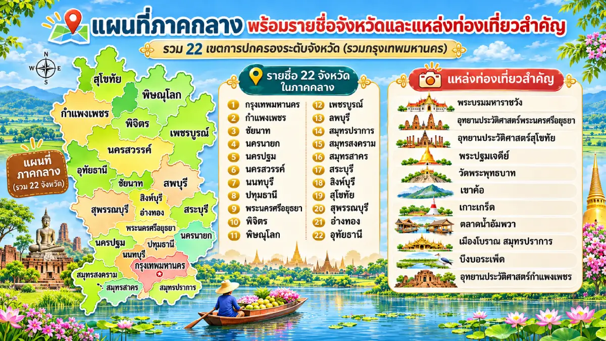
The map of Central Thailand covers 22 province-level administrative areas—21 ordinary provinces and Bangkok. These are Bangkok, Kamphaeng Phet, Chai Nat, Nakhon Nayok, Nakhon Pathom, Nakhon Sawan, Nonthaburi, Pathum Thani, Phra Nakhon Si Ayutthaya, Phichit, Phitsanulok, Phetchabun, Lop Buri, Samut Prakan, Samut Songkhram, Samut Sakhon, Saraburi, Sing Buri, Sukhothai, Suphan Buri, Ang Thong and Uthai Thani. This geographical approach includes several lower northern provinces in the central region, unlike administrative systems that classify them as part of Northern Thailand.
Central Thailand has been pivotal to the development of the country, containing the Chao Phraya River basin and other major floodplains as well as important royal capitals from different periods. Its upper reaches include mountains, intermontane plains and the basins of the Ping, Wang, Yom and Nan rivers. These waterways converge to form the Chao Phraya at Nakhon Sawan, which then flows across the central plains into the Gulf of Thailand. Their river systems have historically sustained settlement, farming, trade and urban growth.
Kamphaeng Phet Province is located in upper Central Thailand under the geographical classification used here, bordering the Ping River and western mountain ranges. Historically, it was an important ancient town associated with the Sukhothai and Ayutthaya kingdoms. Kamphaeng Phet Historical Park forms part of the UNESCO World Heritage property known as the Historic Town of Sukhothai and Associated Historic Towns. Khlong Lan National Park adds waterfalls and forests, making the province notable for both its ancient urban heritage and natural attractions.
Sukhothai Province holds an important place in Thai history as the center of the former Sukhothai state. Sukhothai Historical Park and Si Satchanalai Historical Park preserve archaeological remains and artworks that illustrate developments in Buddhism, architecture and governance during the Sukhothai period. The province also retains the tradition of making Sangkhalok ceramics and other local crafts rooted in the history of its ancient communities.
Phitsanulok Province is an important city in the Nan River basin with historical roles during the Sukhothai and Ayutthaya periods. Wat Phra Si Rattana Mahathat Woramahawihan houses Phra Phuttha Chinnarat, one of Thailand's most revered Buddha images. Phitsanulok also serves as a major transport link between upper Central Thailand and other regions. Natural attractions include Phu Hin Rong Kla National Park, notable for its landscapes and history.
Phichit Province occupies the lowlands of the Nan and Yom rivers, where agriculture and riverside communities have long shaped daily life. Important attractions include Bueng Si Fai, Wat Tha Luang and historic sites associated with old Phichit. The province is also known for the legend of the crocodile lord Chalawan and traditional longboat races, both illustrating the longstanding bond between local people and the rivers.
Phetchabun Province lies in a landscape of mountains surrounding lowland basins along the Pa Sak River, setting it apart from the broad plains of lower Central Thailand. Notable destinations include Si Thep Historical Park, Khao Kho, Phu Thap Boek and Nam Nao National Park. Si Thep Historical Park was inscribed on the UNESCO World Heritage List in 2023. Phetchabun stands out for archaeology, natural scenery and cooler upland environments.
Nakhon Sawan Province occupies a strategic position at the upper end of the Chao Phraya basin. At Pak Nam Pho, the Ping and Nan rivers meet to form the Chao Phraya River. The province has long served as a transportation and trading center between Central Thailand and northern areas. Attractions include Bueng Boraphet, Wat Khiriwong and sites presenting the heritage of Pak Nam Pho communities. Its famous Chao Pho–Chao Mae Pak Nam Pho procession preserves a longstanding Thai-Chinese cultural tradition.
Uthai Thani Province contains both the Sakae Krang River floodplain and forested mountains to the west. Its riverside settlements preserve distinctive ways of life connected to the waterways. Important sites include Wat Sangkat Rattana Khiri, Wat Chantharam (Wat Tha Sung), Hup Pa Tat and Huai Kha Khaeng Wildlife Sanctuary, part of a UNESCO natural World Heritage property. Uthai Thani is valuable for its community history, nature and forest conservation.
Chai Nat Province lies in the Chao Phraya River basin and is especially important for agriculture and water management. The Chao Phraya Dam is a major irrigation structure that regulates water distribution across the central plains. The province also contains historic riverside settlements and temples such as Wat Phra Borommathat Worawihan, together with educational sites explaining how irrigation has supported agricultural development in the floodplain.
Sing Buri Province occupies the Chao Phraya floodplain and is historically associated with the resistance of the Bang Rachan villagers during the late Ayutthaya period. Key attractions include the Bang Rachan Heroes Monument, Wat Phra Non Chaksi Worawihan and Wat Phikun Thong. Agricultural communities and local traditions also retain a close connection with the Chao Phraya River and its tributaries.
Ang Thong Province consists predominantly of lowlands along the Chao Phraya and Noi rivers and is known for agriculture and historic Buddhist sites. Notable places include Wat Khun Inthapramun, home to a large reclining Buddha, Wat Muang and traditional craft communities. Ang Thong also has historical links with Ayutthaya and continues to preserve the culture of Thailand's central river basin.
Lop Buri Province is an important historic city with evidence of habitation dating back to ancient times. Its monuments reveal influences from the Dvaravati, Khmer and Ayutthaya cultures. Major sites include Phra Prang Sam Yot, King Narai's Palace and Wat Phra Si Rattana Mahathat. The province also has extensive farmland and seasonal nature attractions, especially its well-known sunflower fields.
Saraburi Province is situated where the central lowlands meet mountain ranges to the east. It is important for transportation and industry, and is home to Wat Phra Phutthabat Ratchaworamahawihan, one of Thailand's renowned Buddhist pilgrimage sites. Natural attractions include Namtok Chet Sao Noi and forested mountain areas connected to the Dong Phaya Yen Range.
Phra Nakhon Si Ayutthaya Province contains the former capital of the Ayutthaya Kingdom, whose history spans more than 400 years. Ayutthaya was once a major political, economic, trading and cultural center of Southeast Asia. Its landmarks include Ayutthaya Historical Park, Wat Mahathat, Wat Phra Si Sanphet, Wat Chaiwatthanaram and Wat Yai Chai Mongkhon. The Historic City of Ayutthaya is recognized as a UNESCO cultural World Heritage property, making the province indispensable to understanding Thai history, art and the development of past society.
Suphan Buri Province lies in the Tha Chin River basin and is important for agriculture and the history of old towns. Attractions include Wat Pa Lelai Worawihan, Sam Chuk Market and Suphan Buri National Museum. The province is linked with the classic Thai literary work Khun Chang Khun Phaen and preserves old market communities and farming lifestyles that express the culture of Central Thailand.
Nakhon Nayok Province lies at the transition between the central plains and the Dong Phaya Yen mountains. It contains agricultural land, forests, waterfalls and other natural landscapes. Well-known attractions include Khun Dan Prakan Chon Dam, Sarika Waterfall, Nang Rong Waterfall and parts of Khao Yai National Park. The province is an instructive place to observe the contrast between lowland and mountainous environments.
Pathum Thani Province, immediately north of Bangkok, contains Chao Phraya floodplains and an extensive irrigation canal network. It has evolved into an important residential, educational, industrial and scientific area. Attractions include Wat Bot, Wat Chedi Hoi and the National Science Museum at Khlong Ha. Pathum Thani illustrates the transformation of farming and canal-side communities into a modern urban region closely integrated with Bangkok.
Nonthaburi Province lies north and west of Bangkok, with a long history of communities along the Chao Phraya River. Notable places include Ko Kret, Wat Chaloem Phra Kiat Worawihan and historic neighborhoods of Pak Kret. The province is especially known for Mon culture, including Ko Kret pottery, as well as fruit orchards and riverside lifestyles that form an important part of Central Thailand's heritage.
Nakhon Pathom Province plays an important role in the history of Buddhism and ancient settlements in the central river plains. Its best-known landmark, Phra Pathom Chedi, is a large religious monument and symbol of the province. Nakhon Pathom also contains Dvaravati-period archaeological remains, canal-side communities and agricultural areas, including orchards and farms in Sam Phran District. The province offers a compelling connection between early Thai history and contemporary life in Central Thailand.
Samut Prakan Province occupies the mouth of the Chao Phraya River where it meets the Gulf of Thailand. It is important for ports, industry, transportation and the history of coastal defense. Attractions include Phra Samut Chedi, Phra Chulachomklao Fort, the Ancient City and the Erawan Museum. The province is also home to Suvarnabhumi Airport, one of Thailand's major air transport hubs. Samut Prakan illustrates the transition from a historic river-mouth settlement to a modern economic and transport center.
Samut Sakhon Province lies along the Gulf of Thailand and the Tha Chin River basin. Fisheries, aquaculture, seafood processing and industry are central to its economy. Major landmarks include the Phanthai Norasing Shrine, Mahachai Market and coastal fishing communities. The province illustrates how marine resources and waterborne transport have continually influenced livelihoods, commerce and settlement.
Samut Songkhram Province is relatively small but geographically and culturally distinctive. It lies at the mouth of the Mae Klong River beside the Gulf of Thailand, with numerous canals and fruit orchards. Attractions include Amphawa Floating Market, the Railway Market (Talat Rom Hup), Wat Bang Kung and traditional canal-side neighborhoods. Coconut plantations, coconut sugar production and riverside life continue to preserve generations of local knowledge.
Bangkok is Thailand's capital and the national center of administration, economy, transportation and culture. It lies in the lower Chao Phraya floodplain and has long been shaped by its network of rivers and canals. Bangkok was established as the capital in 1782 under King Rama I (Phra Phutthayotfa Chulalok). Major heritage sites include the Grand Palace, Wat Phra Kaew, Wat Pho and Wat Arun, which preserve important national architecture, history and Buddhist art.
Bangkok also has considerable cultural diversity because it attracts residents from every region of Thailand as well as people from other countries. This is reflected in its foods, neighborhoods, historic markets, religious buildings and heritage quarters. Yaowarat (Chinatown), Kudi Chin, Bang Lamphu and Talat Noi are examples of areas where international trade and cultural exchange have continually influenced the development of the capital.
Central Thailand's geography differs sharply between its upper and lower areas. Upper Central Thailand has mountain ranges, intermontane plains and the Ping, Yom and Nan river basins. Lower Central Thailand encompasses the Chao Phraya, Tha Chin and Mae Klong floodplains, estuaries and Gulf of Thailand coastlines. These environments sustain a wide range of economic activities and livelihoods, from rice growing, orchards and field crops to fishing, industry, trading and services in major cities.
Central Thailand has also been central to the country's political and cultural history. It contains important royal capitals from different eras—Sukhothai, Ayutthaya and Bangkok—as well as ancient towns and trading settlements along major waterways. This legacy is visible in palaces, temples, defensive walls, archaeological sites, traditional markets and historic neighborhoods valued for their architecture and cultural heritage. The region is therefore essential for studying the evolution of Thai states and society from the past to the present.
The traditions of Central Thailand are strongly associated with agricultural society and waterways. Examples include longboat racing, the Tak Bat Dok Mai flower-offering festival in Saraburi, the Rap Bua lotus-receiving tradition in Samut Prakan and numerous Buddhist observances in local communities. Folk performances, regional cuisine and handicrafts further express each province's identity. Even within the same region, traditions vary according to the particular histories and backgrounds of individual communities.
Central Thailand is relatively easy to travel around thanks to major roads, railways and public transport routes radiating from Bangkok. Those interested in history can follow a Bangkok–Ayutthaya–Lop Buri itinerary, with the option to continue to Sukhothai and Kamphaeng Phet. Travelers interested in riverside lifestyles can visit Nonthaburi, Nakhon Pathom, Samut Songkhram and Samut Sakhon. Itinerary planning should take account of actual distances, traffic conditions and the kinds of attractions visitors wish to explore.
A close look at the map shows that Central Thailand is not confined to the Chao Phraya's flat lower basin. Under the classification used in this article, it also contains mountains and historic northern towns such as Phetchabun, Phitsanulok, Sukhothai and Kamphaeng Phet. Grouping these areas together helps explain the physical continuity of the river systems and the development of settlements from their upper catchments down to the Gulf of Thailand.
In summary, Central Thailand's 22 province-level areas are distinguished by their royal capitals, major river basins, farmland, economic centers and cultural variety. They range from the historic cities of Sukhothai and Kamphaeng Phet in the upper region to Ayutthaya and Bangkok farther south, and include the coastal provinces of Samut Prakan, Samut Sakhon and Samut Songkhram, where river and maritime livelihoods have long prevailed. This diversity makes Central Thailand fundamental to understanding the country's geography, history and development.
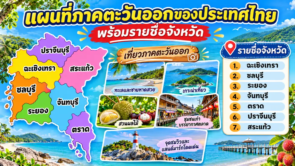
The map of Eastern Thailand includes 7 provinces: Chanthaburi, Chachoengsao, Chon Buri, Trat, Prachin Buri, Rayong and Sa Kaeo. The region features varied terrain, including the Bang Pakong river plains, mountains, forests, farmland, Gulf of Thailand coastlines and numerous islands. Eastern Thailand has important economic, industrial, international trade, fruit-growing and tourism activities. Coastal destinations attract many travelers, while inland national parks, historic sites and culturally distinctive communities provide different experiences.
The landscape of Eastern Thailand varies between its upper and lower areas. Prachin Buri and Sa Kaeo have mountains, forests and plains connected to Central and Northeastern Thailand, while Chachoengsao occupies the Bang Pakong River basin, which has long supported agriculture and settlement. Chon Buri, Rayong, Chanthaburi and Trat include Gulf of Thailand coastlines, islands and natural bays that form major tourist destinations. As a result, Eastern Thailand encompasses industrial cities, seaside resorts, agricultural communities and border-trade towns within a single region.
Chanthaburi Province is in eastern Thailand and combines mountain ranges, forests, river plains and Gulf of Thailand coastline. The province is celebrated for fruit cultivation, particularly durian, mangosteen, rambutan and longkong, supported by humid weather and rainfall suitable for orchards. Chanthaburi is also an important Thai center for gemstone cutting and trade, giving rise to culturally diverse merchant communities.
Chanthaburi's major sites include the Cathedral of the Immaculate Conception, the Chanthaboon Waterfront Community, Namtok Phlio National Park, Chao Lao Beach and Laem Sing, where historic sites meet scenic coastal landscapes. Local culture reflects interaction among Thai, Chinese and Vietnamese communities, especially along Chanthaburi's old riverfront, where historic buildings, religious sites and trading traditions continue to reveal the city's past.
Chachoengsao Province, traditionally called Paet Riu, lies in the Bang Pakong River basin, with farmland and riverside communities whose history extends back many generations. The river has long served transportation, trade and local livelihoods. Chachoengsao also connects Bangkok with Thailand's eastern coastal provinces, giving it an important role in agriculture, regional transport and economic development.
Major attractions in Chachoengsao include Wat Sothon Wararam Worawihan, home to the revered Luang Pho Sothon Buddha image. Other sites include Ban Mai Market on the Bang Pakong River, Wat Saman Rattanaram and historic riverside communities that preserve local ways of life. Festivals honoring Luang Pho Sothon and other cultural celebrations illustrate the longstanding relationship among Buddhism, local communities and the Bang Pakong River.
Chon Buri Province is a Gulf of Thailand coastal province important for business, industry, tourism and international transportation. Major industrial and port operations are concentrated around Laem Chabang. At the same time, popular seaside destinations include Bang Saen, Pattaya, Ko Lan and Ko Si Chang, attracting Thai and international visitors. Pattaya is internationally recognized as a resort city offering a wide range of tourist facilities and services.
Chon Buri also has distinctive local customs. The Buffalo Racing Festival is an important tradition rooted in earlier farming life; other examples include the Kong Khao tradition around Si Racha and seafood culture in coastal communities. These practices show the relationship between local residents and marine resources. Chon Buri is therefore characterized by both traditional community life and the rapid growth of modern tourist cities.
Trat Province lies at the eastern end of Thailand's Gulf coastline and borders Cambodia. Its terrain includes coastal plains, forests, mangroves and many offshore islands. Important destinations include Ko Chang, Ko Kut, Ko Mak and surrounding coastlines, known for beaches, clear waters and diverse marine habitats. Trat is a key province for island tourism and conservation of the eastern region's natural resources.
Beyond seaside tourism, Trat is known for fruit production, fisheries and border commerce, especially around Khlong Yai District and the Ban Hat Lek border area, which has economic ties with Cambodia. Many communities still practice traditional fishing, fruit growing and coastal ways of life. Visitors can therefore combine island scenery and marine activities with opportunities to learn about local livelihoods.
Prachin Buri Province is located in upper Eastern Thailand and has plains interspersed with mountains and forests, particularly where it borders Khao Yai National Park and the Dong Phaya Yen Range. It has important agricultural and industrial activities, alongside historical and archaeological remains indicating human settlement since ancient times.
Important attractions in Prachin Buri include the ancient town of Si Mahosot, the Sa Morakot archaeological complex, Prachin Buri National Museum and natural sites in the surrounding mountains and forests. The province is also associated with medicinal herbs and traditional Thai medicine, particularly around Mueang Prachin Buri and Prachantakham districts. It offers a combination of ancient urban history, natural landscapes and knowledge of medicinal plant resources.
Rayong Province lies on the Gulf of Thailand and plays a major role in industry, energy, tourism and agriculture, especially the cultivation of durian, mangosteen and rambutan. Popular coastal destinations include Ko Samet, Mae Ramphueng Beach, Laem Mae Phim and other relaxing seaside locations. The province also has natural attractions in Khao Chamao–Khao Wong National Park, where forests, waterfalls and significant ecosystems are protected.
Rayong's cultural heritage includes Yomjinda Road, a historic trading district, and Phra Chedi Klang Nam, a riverside pagoda connected to the history of local communities along the Rayong River. The province is also associated with Sunthorn Phu, one of Thailand's best-known poets, whose monument stands in Klaeng District. Rayong thus brings together modern industry, historic settlements, fruit-growing districts and seaside tourism.
Sa Kaeo Province occupies Thailand's eastern border with Cambodia. Aranyaprathet District is especially important for cross-border trade and international travel. The province includes plains, forests and some mountain areas, as well as ancient monuments illustrating historic Khmer cultural influence.
Important sites in Sa Kaeo include Prasat Sdok Kok Thom, a historically significant Khmer sanctuary, Pang Sida National Park and Lalu, a landscape of naturally eroded earth formations. The province offers a clear view of how border history, archaeology and nature overlap, while commerce and transportation across the Thai–Cambodian frontier remain important to its economy.
Eastern Thailand's culture is diverse because of centuries of trade, migration and settlement involving Thai, Chinese, Vietnamese and various local communities. Their histories remain visible in old-town architecture, religious sites, traditional markets, cuisine and festivals. The Bang Pakong riverside, Chanthaburi's historic neighborhoods and Gulf of Thailand port towns demonstrate especially clearly how waterborne trade shaped regional communities.
Eastern Thailand is one of the country's major fruit-producing regions, especially Chanthaburi, Rayong and Trat. Their rainfall and climate favor durian, mangosteen, rambutan and other tropical fruits. During harvest season, communities often organize agricultural tourism activities and open orchards to visitors interested in cultivation and fruit picking. Fruit production has therefore become an important part of the region's economic and cultural identity.
Travelers can plan an eastern coastal route connecting Chachoengsao, Chon Buri, Rayong, Chanthaburi and Trat, or explore an inland itinerary through Prachin Buri and Sa Kaeo for natural attractions and border history. For island trips, it is important to check ferry timetables, sea conditions and local travel seasons. Visitors interested in orchards should match their trips to each province's harvest season to experience the most relevant local activities.
In summary, Eastern Thailand's 7 provinces are distinguished by beaches and islands, fruit cultivation, industry, border commerce and diverse community cultures. They range from the resort and coastal provinces of Chon Buri, Rayong, Chanthaburi and Trat to Chachoengsao's river settlements and the mountainous and border areas of Prachin Buri and Sa Kaeo. These differences make the east a major contributor to Thailand's economy and tourism.
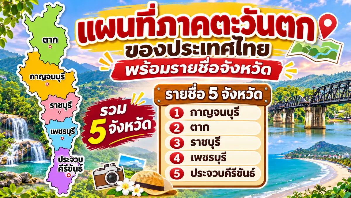
The map of Western Thailand covers 5 provinces: Kanchanaburi, Tak, Prachuap Khiri Khan, Phetchaburi and Ratchaburi. Its landscape is dominated by mountain ranges, forests, major rivers and extensive borderlands adjoining Myanmar. Many ranges run north to south, especially the Thanon Thong Chai and Tenasserim mountains, which form important natural divisions between Thailand and Myanmar. The region's southern area also includes Gulf of Thailand coastal provinces important for tourism, agriculture and fisheries.
Western Thailand is rich in natural resources, with numerous protected forests, national parks and wildlife sanctuaries. The connected forest landscapes of the Tenasserim Range provide important watersheds and habitats for many species. River valleys and foothill plains, meanwhile, are home to farming communities, historic towns and border-trading routes formed through longstanding contact between people living on both sides of the frontier.
Kanchanaburi Province is a large western province with mountains, forests, rivers and extensive reservoirs. The Khwae Yai and Khwae Noi rivers meet near Kanchanaburi town to form the Mae Klong River. The province is internationally known for its Second World War history, especially the Bridge over the River Kwai and the Death Railway, sites central to understanding the experiences and events surrounding construction of the Thailand–Burma Railway.
Kanchanaburi's natural highlights include Erawan Waterfall, Sai Yok Waterfall, Srinagarind Dam, Khuean Srinagarindra National Park and protected forests near the border. Historical and archaeological attractions include Prasat Mueang Sing and the old town of Kanchanaburi. The province is also home to diverse ethnic communities, notably Mon and Karen settlements in some districts, whose languages, customs and daily lives are closely connected with the border environment.
Tak Province is located in the northern part of Western Thailand under the classification followed here. It has a long border with Myanmar and predominantly mountainous terrain. Tak has historically been important for border relations and commerce, especially Mae Sot District, now one of Thailand's key border-economy centers. The Ping River also crosses the province, which contains Bhumibol Dam, an important national water-resource and energy development project.
Attractions in Tak include Namtok Pha Charoen National Park, Taksin Maharat National Park, Thi Lo Su Waterfall in Umphang Wildlife Sanctuary and Bhumibol Dam. Thi Lo Su is particularly celebrated for its spectacular waterfall landscape and forest ecology. Tak has many ethnic cultural traditions, and the province's distinctive Loy Krathong Sai Lai Prathip Phan Duang festival—a procession of floating lights—reflects the relationship between Buddhist customs and life along the Ping River.
Prachuap Khiri Khan Province extends along a long section of the Gulf of Thailand coast, with the Tenasserim mountains to the west along the Myanmar border. It contains mountains, forests, coastal plains and beaches. Well-known attractions include Hua Hin, Khao Sam Roi Yot National Park, Ao Manao and the coast around Pran Buri and Bang Saphan. It is one of Thailand's major seaside destinations, particularly Hua Hin, whose history is linked with the rise of railway travel and coastal holidays.
Prachuap Khiri Khan also contains Kui Buri National Park, an important area for wildlife protection in the Tenasserim forest landscape. Khao Sam Roi Yot National Park features limestone mountains, wetlands and coastline, including the famous Phraya Nakhon Cave. The province therefore provides an outstanding example of mountain and coastal ecosystems existing close together.
Phetchaburi Province is important for history, traditional arts, food and natural landscapes. Its inland areas contain mountains and forests, while agricultural plains and Gulf of Thailand coastline occupy lower ground. Phetchaburi town has a long history and numerous temples with valuable historic artworks. Major attractions include Phra Nakhon Khiri (Khao Wang), Phra Ram Ratchaniwet Palace, Wat Yai Suwannaram and Wat Mahathat Worawihan, which reflect artistic and architectural achievements of different eras.
Phetchaburi is also celebrated for Thai food and desserts, particularly khanom mo kaeng custard, thong yip, thong yot and sweets made with locally produced palm sugar. These traditions reflect knowledge of regional resources. Natural attractions include Kaeng Krachan National Park, part of the UNESCO-listed Kaeng Krachan Forest Complex, and Cha-am Beach on the Gulf of Thailand. The province combines cultural heritage and nature in a particularly compelling way.
Ratchaburi Province lies west of Thailand's lower central plains but belongs to Western Thailand under the geographical division used here. Its west is mountainous, while the east includes lowlands along the Mae Klong River. Ratchaburi has a long history of trade and settlement within the river basin and is home to Thai, Chinese, Mon and other cultural communities that have influenced its towns and handicrafts.
Major attractions in Ratchaburi include Damnoen Saduak Floating Market, Khao Ngu Stone Park, Wat Khanon—known for its traditional nang yai large shadow puppetry—and the natural attractions of Suan Phueng District. The province is also famous for ceramics, especially the distinctive Ratchaburi dragon jars, a craft shaped by Thai-Chinese pottery skills and commerce. Ratchaburi illustrates enduring connections between waterways, trading communities and traditional arts.
The west has considerable ethnic and cultural diversity because people have traveled between inland Thailand and Myanmar for centuries. Mon, Karen and other communities maintain distinctive languages, clothing, knowledge and traditions. Their cultural contributions are visible in cuisine, handicrafts, religious sites and ways of life in mountain settlements and river valleys.
Western Thailand is also vital for conservation. The forests along the Tenasserim mountains and adjoining protected areas support wildlife habitats and major watersheds. Nature tourism in Kanchanaburi, Tak, Phetchaburi and Prachuap Khiri Khan should therefore emphasize environmental protection, compliance with protected-area regulations and activities suited to sensitive ecosystems, especially trekking, waterfall visits and wildlife observation.
For travel in Western Thailand, visitors can combine Ratchaburi, Phetchaburi and Prachuap Khiri Khan to explore local culture and seaside destinations. Another route links Kanchanaburi and Tak for border history and mountain scenery. Because the region has extensive highlands, some journeys take considerable time, particularly toward Umphang District in Tak and remote forest areas of Kanchanaburi. Travelers should check road conditions, forecasts and access regulations before departure.
In summary, Western Thailand's 5 provinces are important for border geography, forests, watersheds, history and varied local cultures. Tak and Kanchanaburi contain extensive mountains and protected forests, Ratchaburi and Phetchaburi preserve historic towns and crafts, and Prachuap Khiri Khan has a long coast and famous natural attractions. Together they make the region important both for conservation and for understanding Thai history.
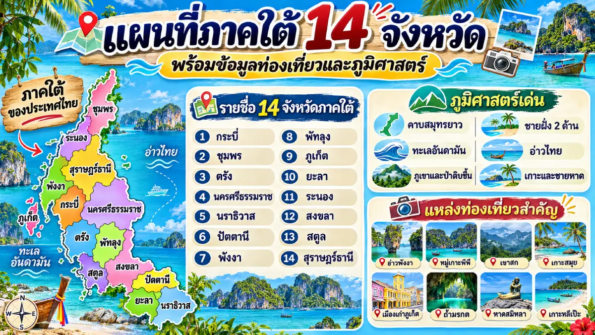
The map of Southern Thailand covers 14 provinces: Krabi, Chumphon, Trang, Nakhon Si Thammarat, Narathiwat, Pattani, Phang Nga, Phatthalung, Phuket, Yala, Ranong, Satun, Songkhla and Surat Thani. The region is a long peninsula extending from Chumphon and Ranong in the north to the Thai–Malaysian border. The Andaman Sea lies to the west and the Gulf of Thailand to the east. Mountains, forests, coastal plains, mangroves, islands and wetlands give Southern Thailand remarkable environmental and ecological diversity.
Southern Thailand's climate is influenced by 2 principal monsoon periods. The Andaman coast is particularly affected by the southwest monsoon, while the Gulf of Thailand coast receives the northeast monsoon toward the end of the year. Consequently, the best seasons for beach and island travel do not coincide on both shores. Travelers should consider local weather, sea conditions and marine safety advisories when planning coastal journeys.
Southern Thailand has an important history of international commerce because it lies along maritime routes and links connecting the Malay Peninsula with other parts of Southeast Asia. Port towns and trading communities developed with varied cultural backgrounds, including Thai Buddhists, Thai Muslims, people of Chinese descent and other local populations. This diversity remains evident in languages, cuisine, architecture, religious buildings, traditions and everyday life throughout the southern provinces.
Krabi Province lies on the Andaman coast and is known for dramatic limestone mountains, sheer cliffs, beaches and scenic islands. Important destinations include Ao Nang, Railay Beach, the Phi Phi Islands, Ko Lanta and Talay Waek, where sandbars emerge at low tide. These natural attractions welcome visitors from around the world. Krabi also has forests, waterfalls, natural hot springs and coastal habitats important for marine conservation.
Krabi has a long history of human settlement, evidenced by archaeological sites and rock paintings in caves and on limestone cliffs. These remains show how people interacted with coastal terrain in prehistoric times. Fishing communities and island settlements continue to preserve traditional lifestyles and local dishes based on seafood and herbs. The province is therefore significant for marine tourism, geology and the history of coastal communities.
Chumphon Province occupies the upper southern peninsula, stretching along the Gulf of Thailand with the Tenasserim mountains to the west. It forms an important connection between lower Central Thailand and the South, crossed by major highways and rail lines. Popular coastal attractions include Sai Ri Beach, Thung Wua Laen Beach, Mu Ko Chumphon National Park and other areas suitable for marine recreation.
Chumphon is also important for agriculture and fisheries, particularly Robusta coffee, durian and other economic crops alongside coastal fishing. Another significant landmark is the Shrine of Prince Chumphon Khet Udomsak at Sai Ri Beach, respected by local residents and people connected with maritime activities. The province has strong links with sea transportation, the history of the Royal Thai Navy and Gulf coast tourism.
Trang Province lies on the Andaman coast and includes mountains, coastal plains, mangrove forests and beautiful islands. It is known for marine attractions such as Ko Kradan, Ko Muk, Ko Ngai and the Emerald Cave, whose coastal ecosystems and landscapes make them popular destinations. Inland attractions include Tham Le Khao Kop and historic communities that reveal aspects of Trang's urban past.
Trang has a distinctive food culture, especially Trang-style roast pork and Thai-Chinese-influenced breakfasts featuring dim sum and local pastries. Its history also involves maritime commerce and urban development under Phraya Ratsadanupradit Mahison Phakdi, an important figure in southern economic development and the introduction of rubber cultivation. Trang's identity therefore encompasses coastal nature, town history and unique culinary traditions.
Nakhon Si Thammarat Province is one of Southern Thailand's major historical and cultural centers, extending from the Nakhon Si Thammarat mountain range to the Gulf of Thailand. The city has a long history and was an important center for the spread of Buddhism on the southern peninsula. Wat Phra Mahathat Woramahawihan is an important focus of local devotion and is closely associated with the longstanding Hae Pha Khuen That cloth-offering procession.
Nakhon Si Thammarat's cultural heritage includes nang talung shadow puppetry, nora dance-drama, niello metalwork and other traditional crafts illustrating southern artisans' skills. Its natural attractions include Khiriwong Village, Khao Luang National Park and the coastline around Khanom District. The mountainous areas form important watersheds and support rich biodiversity. The province is consequently central to the study of Buddhist history, traditional culture and southern nature.
Narathiwat Province lies in southernmost Thailand, bordering Malaysia and the Gulf of Thailand. Its terrain includes beaches, peat-swamp forests, floodplains and mountains near the frontier. Significant attractions include Narathat Beach, Wat Chon Thara Singhe and the Hala–Bala forest area, an important natural resource and biodiversity center of the deep south.
Narathiwat is distinguished by local Malay cultural traditions expressed through language, religion, cuisine and handicrafts. Both Thai Muslim and Thai Buddhist communities live in the province. A noted local craft is the colorful kolae boat, with ornate painted designs that reflect the skills of coastal communities. This cultural variety forms an essential part of the deep south's identity and illustrates connections between border geography and the history of local people.
Pattani Province has a history connected with seaports and trading centers on the Malay Peninsula. It borders the Gulf of Thailand and retains traditions influenced by the former Pattani kingdom. Important religious landmarks include Pattani Central Mosque, Krue Se Mosque and the Chao Mae Lim Ko Niao Shrine, illustrating the range of religions and beliefs found among the province's communities.
Pattani's identity also includes local food, arts and crafts and customs shaped by Malay and Thai-Chinese cultures. Batik textiles and products with locally distinctive patterns are particularly notable. The coast and Pattani River have long played vital roles in settlement and livelihoods, giving the province historical and cultural characteristics different from many other areas of Thailand.
Phang Nga Province lies on the Andaman coast and is characterized by limestone karsts, natural bays, mangroves and numerous islands. Famous sites include Ao Phang Nga National Park, Khao Tapu (James Bond Island), Ko Panyi, the Similan Islands and the Surin Islands. These areas are renowned for extraordinary landscapes and marine ecosystems, especially coral reefs and diving sites important to Thailand's tourism economy.
Phang Nga also has Khao Lak, a major coastal destination for relaxation and marine activities. Fishing villages and island communities continue to maintain traditional lifestyles. Ko Panyi is especially distinctive because much of its settlement is built on structures above the water in Phang Nga Bay. The province offers valuable experiences of coastal geomorphology, nature tourism and Andaman Sea community culture.
Phatthalung Province lies on the eastern side of the southern peninsula, with mountain ranges, agricultural lowlands and wetlands connected to the Songkhla Lake system. Its best-known natural landmark is Khao Ok Thalu, a limestone mountain with a visible opening near its summit overlooking Phatthalung town. Another major attraction is Thale Noi, an ecologically important wetland supporting many species of waterbirds.
Phatthalung is also known for traditional southern performing arts, especially nora and nang talung, which express local stories, music, beliefs and inherited knowledge. Around Thale Noi, communities maintain livelihoods associated with fishing, raising water buffalo and making crafts from local plants. The province offers a valuable setting for exploring the connections among wetlands, traditional culture and the daily life of southern communities.
Phuket Province is a large island in the Andaman Sea and one of Thailand's internationally famous beach destinations. It has numerous beaches and bays, including Patong, Kata and Karon beaches and the scenic viewpoint at Promthep Cape. Phuket's tourism infrastructure includes an international airport, ports, hotels and a wide range of visitor services.
Beyond its beaches, Phuket has a history of tin mining and international trade, especially through its Chinese-descended communities, which played an important role in the town's development. Their legacy is visible in Sino-Portuguese architecture in Phuket Old Town and distinctive traditions such as local Phuket cuisine, the Vegetarian Festival and Baba–Yaya dress. This combination makes Phuket important both as a modern tourism economy and as a historic trading-port cultural center.
Yala Province occupies the southernmost part of Thailand's mainland, borders Malaysia and contains mountains, forests and intermontane plains. It has no coastline, but offers striking inland landscapes. Betong District is particularly mountainous and can be cooler than surrounding lowlands at certain times of year. Attractions include the Aiyerweng Sea of Mist viewpoint, Aiyerweng Skywalk, Betong Hot Springs and Wat Khuha Phimuk.
Yala also has a diverse cultural and religious landscape, with Thai Buddhist, Thai Muslim and Thai-Chinese communities living in the province. Yala city is known for its orderly urban layout and public spaces, while Betong has distinctive borderland cuisine and traditions, including Betong chicken and foods influenced by Chinese and Malay communities. Yala is therefore notable for upland geography, frontier cultures and the settlement history of the southern peninsula.
Ranong Province lies on the upper southern Andaman coast and borders Myanmar. Its landscape includes mountains, forests, mangroves and shoreline. The southwest monsoon gives Ranong substantial rainfall during much of the year. Major attractions include Raksawarin Hot Springs, Ko Phayam, Phu Khao Ya (Grass Hill) and natural destinations along the coast and islands.
Ranong's history is associated with tin mining and border trade, and Thai-Chinese communities played an important role in the town's development. The former governor's residence and surviving old buildings evoke the people who settled and worked here. Local foods and products include the well-known Thap Li steamed buns. Ranong combines the heritage of a mining town with mountain forests and Andaman coastal life.
Satun Province occupies southwestern Thailand, bordering Malaysia and the Andaman Sea. It contains limestone mountains, mangroves, coastline and islands rich in natural diversity. Popular attractions include Mu Ko Tarutao National Park, Ko Lipe, Ko Adang and natural sites within Satun Geopark, whose geology preserves evidence of Earth's history in rock strata and fossils.
In 2018, Satun Geopark became Thailand's first UNESCO Global Geopark. Important geological sites include Tham Le Stegodon, Phu Pha Phet Cave and ancient rock formations that record changes in past environments. Satun also has a diverse cultural heritage shaped by Malay communities and cross-border commerce, alongside local cuisine and fishing livelihoods connected to marine resources.
Songkhla Province is a major southern center of economy, education and transportation, bordering Songkhla Lake, the Gulf of Thailand and Malaysia. Hat Yai District serves as a significant commercial and transport hub, while Songkhla town has a long history as a coastal trading port. Major attractions include Samila Beach, Songkhla Old Town, Tang Kuan Hill and communities along Songkhla Lake.
Songkhla's cultural landscape reflects the blending of Thai, Chinese and Malay communities. The historic quarter contains old buildings, temples and markets that preserve evidence of maritime trade. The province is also known for diverse local foods and traditions, including nora and nang talung, important performing arts of Southern Thailand. Songkhla therefore combines a contemporary economic role with the preservation of old-town cultural heritage.
Surat Thani Province is a large and geographically varied southern province with mountains, forests, river plains and islands in the Gulf of Thailand. Well-known natural destinations include Ko Samui, Ko Pha Ngan, Ko Tao and Mu Ko Ang Thong National Park, famous for beaches and marine ecosystems. Inland attractions include Khao Sok National Park and Ratchaprapha Dam, where limestone mountains, forests and a large reservoir create memorable landscapes.
Surat Thani also has an important place in southern history and culture, especially Chaiya District, where archaeological and religious sites such as Wat Phra Borommathat Chaiya Ratchaworawihan are associated with early peninsular communities. Buddhist customs include Chak Phra processions and Thot Pha Pa robe-offering traditions. Agricultural and fishing communities add to the diversity of local life, making Surat Thani notable for history, nature and marine tourism.
Southern Thailand has exceptional marine resources because it borders both the Gulf of Thailand and the Andaman Sea. On the Gulf side, major destinations include Ko Samui, Ko Pha Ngan, Ko Tao and beaches in Chumphon, Nakhon Si Thammarat, Songkhla and other coastal provinces. The Andaman side contains internationally renowned islands and beaches, including the Phi Phi, Similan and Surin islands, Ko Lipe and Phuket's coastline. The 2 shores differ in landforms, sea conditions and travel seasons.
The South also supports rich biodiversity in tropical forests, mangroves and wetlands, particularly along the Nakhon Si Thammarat mountain ranges, the Hala–Bala forest complex and the Songkhla Lake system. These ecosystems provide habitats for wildlife and waterbirds and are important for agriculture, fisheries and local livelihoods. Nature tourism should therefore emphasize conservation and responsible use of natural resources.
Southern culture reflects the long interaction of peninsular communities with maritime commerce and different religions. Important performing arts include nora and nang talung, while major traditions include Chak Phra boat processions, Hae Pha Khuen That cloth-offering ceremonies and other province-specific festivals. The deep south also has a strong Malay cultural presence expressed in language, cuisine, dress and religious architecture. Together these traditions form a vital part of Thailand's shared cultural heritage and illustrate how people from different historical backgrounds live alongside one another.
Southern Thai cuisine is another expression of the region's identity, drawing on herbs, spices, coconut milk, seafood and locally available ingredients. Well-known dishes include kaeng tai pla, khua kling, kaeng lueang, khao yam and stir-fried stink beans with shrimp paste. Province-specific specialties include Trang roast pork, Betong chicken and Phuket foods influenced by Thai-Chinese culture. Differences in regional recipes reflect variations in natural resources, community histories and cultural exchange throughout the southern peninsula.
Travel in Southern Thailand can be divided into Gulf and Andaman routes. On the Gulf side, travelers can link Chumphon, Surat Thani, Nakhon Si Thammarat, Songkhla, Pattani and Narathiwat. On the Andaman side, a route can connect Ranong, Phang Nga, Phuket, Krabi, Trang and Satun. Phatthalung and Yala also offer natural and cultural attractions suitable for more specialized itineraries. Travel planning should consider monsoon seasons, boat schedules, distances and road conditions, especially for island excursions and remote mountain districts.
Southern Thailand's significance extends well beyond beach tourism. It includes the history of seaports, international trade, diverse cultures, farming, fishing and conservation. Each province has its own character, from historic centers such as Nakhon Si Thammarat and Pattani to marine destinations such as Phuket, Krabi and Phang Nga, the commercial hub of Songkhla and the culturally distinctive border provinces of Satun, Yala and Narathiwat.
In summary, the South's 14 provinces are distinguished by peninsular geography, 2 coastlines, islands, tropical forests and rich cultural diversity. Studying a map of Southern Thailand reveals how landscape shapes the economy and everyday life—from coastal fishing communities and maritime trade to rubber and oil-palm farming, longstanding festivals and inherited crafts. The region is important to Thailand's nature, history and economy alike.
Considering the provinces of all 6 regions together, Thailand's 77 province-level administrative areas display clear differences in geography, history and culture. The north has mountains and Lanna heritage; the northeast has the Khorat Plateau and Mekong basin culture; Central Thailand has major rivers and historic capitals; the east has coasts and fruit-growing districts; the west has forests and frontier landscapes; and the south has a peninsula bordered by 2 seas. These diverse settings are fundamental to Thailand's identity and help explain the many relationships between people and their natural surroundings.
Using a map of Thailand alongside provincial names and regional classifications is valuable for education, research, travel planning and learning about local cultures. Knowing where each province lies makes it easier to connect historical information, physical geography, natural resources and tourist attractions in a systematic way. It is an excellent starting point for exploring all 77 province-level administrative areas of Thailand.
Summary Table: Map of Thailand's 77 Province-Level Administrative Areas in 6 Regions, with Provincial Names in English and Thai
| Country | Thailand (Kingdom of Thailand) |
| Number of Provinces | 76 provinces and Bangkok, a special local administrative authority, making 77 province-level administrative areas in total. |
| Regional Classification | Six geographical regions: Northern, Northeastern, Central, Eastern, Western and Southern Thailand. This classification follows the National Geographical Committee and includes Bueng Kan Province, established in 2011. |
| Northern Thailand 9 Provinces | 1. Chiang Rai (เชียงราย) 2. Chiang Mai (เชียงใหม่) 3. Nan (น่าน) 4. Phayao (พะเยา) 5. Phrae (แพร่) 6. Mae Hong Son (แม่ฮ่องสอน) 7. Lampang (ลำปาง) 8. Lamphun (ลำพูน) 9. Uttaradit (อุตรดิตถ์) |
| Northeastern Thailand (Isan) 20 Provinces | 1. Kalasin (กาฬสินธุ์) 2. Khon Kaen (ขอนแก่น) 3. Chaiyaphum (ชัยภูมิ) 4. Nakhon Phanom (นครพนม) 5. Nakhon Ratchasima (นครราชสีมา) 6. Bueng Kan (บึงกาฬ) 7. Buri Ram (บุรีรัมย์) 8. Maha Sarakham (มหาสารคาม) 9. Mukdahan (มุกดาหาร) 10. Yasothon (ยโสธร) 11. Roi Et (ร้อยเอ็ด) 12. Loei (เลย) 13. Si Sa Ket (ศรีสะเกษ) 14. Sakon Nakhon (สกลนคร) 15. Surin (สุรินทร์) 16. Nong Khai (หนองคาย) 17. Nong Bua Lam Phu (หนองบัวลำภู) 18. Amnat Charoen (อำนาจเจริญ) 19. Udon Thani (อุดรธานี) 20. Ubon Ratchathani (อุบลราชธานี) |
| Central Thailand 22 Province-Level Areas, Including Bangkok | 1. Bangkok (กรุงเทพมหานคร) 2. Kamphaeng Phet (กำแพงเพชร) 3. Chai Nat (ชัยนาท) 4. Nakhon Nayok (นครนายก) 5. Nakhon Pathom (นครปฐม) 6. Nakhon Sawan (นครสวรรค์) 7. Nonthaburi (นนทบุรี) 8. Pathum Thani (ปทุมธานี) 9. Phra Nakhon Si Ayutthaya (พระนครศรีอยุธยา) 10. Phichit (พิจิตร) 11. Phitsanulok (พิษณุโลก) 12. Phetchabun (เพชรบูรณ์) 13. Lop Buri (ลพบุรี) 14. Samut Prakan (สมุทรปราการ) 15. Samut Songkhram (สมุทรสงคราม) 16. Samut Sakhon (สมุทรสาคร) 17. Saraburi (สระบุรี) 18. Sing Buri (สิงห์บุรี) 19. Sukhothai (สุโขทัย) 20. Suphan Buri (สุพรรณบุรี) 21. Ang Thong (อ่างทอง) 22. Uthai Thani (อุทัยธานี) |
| Eastern Thailand 7 Provinces | 1. Chanthaburi (จันทบุรี) 2. Chachoengsao (ฉะเชิงเทรา) 3. Chon Buri (ชลบุรี) 4. Trat (ตราด) 5. Prachin Buri (ปราจีนบุรี) 6. Rayong (ระยอง) 7. Sa Kaeo (สระแก้ว) |
| Western Thailand 5 Provinces | 1. Kanchanaburi (กาญจนบุรี) 2. Tak (ตาก) 3. Prachuap Khiri Khan (ประจวบคีรีขันธ์) 4. Phetchaburi (เพชรบุรี) 5. Ratchaburi (ราชบุรี) |
| Southern Thailand 14 Provinces | 1. Krabi (กระบี่) 2. Chumphon (ชุมพร) 3. Trang (ตรัง) 4. Nakhon Si Thammarat (นครศรีธรรมราช) 5. Narathiwat (นราธิวาส) 6. Pattani (ปัตตานี) 7. Phang Nga (พังงา) 8. Phatthalung (พัทลุง) 9. Phuket (ภูเก็ต) 10. Yala (ยะลา) 11. Ranong (ระนอง) 12. Satun (สตูล) 13. Songkhla (สงขลา) 14. Surat Thani (สุราษฎร์ธานี) |
| Total | 77 Province-Level Administrative Areas: Northern Thailand 9 provinces, Northeastern Thailand 20, Central Thailand 22 province-level areas including Bangkok, Eastern Thailand 7, Western Thailand 5 and Southern Thailand 14. |
Frequently Asked Questions (FAQ)
Q: How many provinces are there in Thailand?
A: Thailand has 76 provinces in its provincial administrative system and Bangkok, a special local administrative authority. Together, they form 77 province-level administrative areas. Bueng Kan, established in 2011, is the most recently created province.
Q: Why do some sources say Thailand has 76 provinces while others say 77?
A: The difference depends on whether Bangkok is counted. Thailand has 76 ordinary provinces; when Bangkok, which has special local administrative status, is included, the total becomes 77 province-level administrative areas. This is why people commonly refer to Thailand as having 77 provinces.
Q: How many geographical regions does Thailand have, and what are they?
A: Under the National Geographical Committee's geographical classification, Thailand has 6 regions: North, Northeast, Central, East, West and South. Some agencies use different regional groupings to suit their administrative responsibilities and specific purposes.
Q: How many provinces are in Northern Thailand, and what are their names?
A: Under the geographical classification used here, Northern Thailand has 9 provinces: Chiang Rai, Chiang Mai, Nan, Phayao, Phrae, Mae Hong Son, Lampang, Lamphun and Uttaradit. The region is known for mountains, valleys and important Lanna cultural heritage.
Q: How many provinces are in Northeastern Thailand, or Isan?
A: Northeastern Thailand has 20 provinces: Kalasin, Khon Kaen, Chaiyaphum, Nakhon Phanom, Nakhon Ratchasima, Bueng Kan, Buri Ram, Maha Sarakham, Mukdahan, Yasothon, Roi Et, Loei, Si Sa Ket, Sakon Nakhon, Surin, Nong Khai, Nong Bua Lam Phu, Amnat Charoen, Udon Thani and Ubon Ratchathani. This includes Bueng Kan, which was established in 2011.
Q: How many provinces are in Central Thailand, and does it include Bangkok?
A: Under the geographical classification used in this article, Central Thailand contains 22 province-level administrative areas: 21 provinces plus Bangkok. This classification includes Sukhothai, Phitsanulok, Phichit, Kamphaeng Phet, Nakhon Sawan, Phetchabun and Uthai Thani, which are grouped with the north under certain other systems.
Q: Which provinces are in Eastern, Western and Southern Thailand?
A: Eastern Thailand has 7 provinces: Chanthaburi, Chachoengsao, Chon Buri, Trat, Prachin Buri, Rayong and Sa Kaeo. Western Thailand has 5: Kanchanaburi, Tak, Prachuap Khiri Khan, Phetchaburi and Ratchaburi. Southern Thailand has 14: Krabi, Chumphon, Trang, Nakhon Si Thammarat, Narathiwat, Pattani, Phang Nga, Phatthalung, Phuket, Yala, Ranong, Satun, Songkhla and Surat Thani.
Q: Why does one map place Tak in Northern Thailand while another places it in Western Thailand?
A: Thailand uses several regional classification systems. The geographical classification of the National Geographical Committee places Tak in Western Thailand, whereas some administrative and economic-development systems group it with the North. Always check which regional classification is being used before referring to a map.
Q: Why is Thailand geographically divided into six regions while LoveThailand.org organizes travel information into only five?
A: Thailand uses several regional classification systems depending on their purposes. Under the geographical classification adopted by the National Geographical Committee, the country is divided into six regions: Northern, Northeastern, Central, Eastern, Western, and Southern Thailand. LoveThailand.org organizes its travel information into five regions to make provincial attractions and travel routes easier to explore. The website considers geographical connections and provincial groupings when organizing destinations. For example, Tak is included in Lower Northern Thailand, while Kanchanaburi, Ratchaburi, Phetchaburi, and Prachuap Khiri Khan are associated with the lower central provincial groups. Consequently, these destinations appear under the Northern and Central Thailand categories respectively. Both classification systems cover all of Thailand, but they serve different purposes.
Q: How many provinces are in Western Thailand, and what are their names?
A: Western Thailand consists of five provinces under the geographical classification adopted by the National Geographical Committee: Kanchanaburi, Tak, Prachuap Khiri Khan, Phetchaburi, and Ratchaburi. The region is characterized by mountain ranges, forests, rivers, and areas bordering Myanmar. However, Thailand's administrative and regional development systems also group these provinces with Northern and Central Thailand. Tak belongs to the Lower Northern Provincial Cluster 1, Kanchanaburi and Ratchaburi belong to the Lower Central Provincial Cluster 1, and Phetchaburi and Prachuap Khiri Khan belong to the Lower Central Provincial Cluster 2. LoveThailand.org follows a travel-oriented regional organization that places these provinces in connected Northern and Central Thailand categories, helping visitors find destinations and plan their journeys more conveniently.
Q: If LoveThailand.org does not have a Western Thailand category, where can travelers find attractions in Kanchanaburi, Tak, Phetchaburi, Ratchaburi, and Prachuap Khiri Khan?
A: LoveThailand.org includes Tak in its Northern Thailand category because the province is part of the Lower Northern provincial grouping and has transportation connections with Sukhothai, Phitsanulok, and other northern destinations. Kanchanaburi, Ratchaburi, Phetchaburi, and Prachuap Khiri Khan are included in Central Thailand, reflecting their connections with the lower central region and travel routes linking Bangkok with western destinations and the Gulf of Thailand coast. This arrangement allows travelers to explore temples, natural attractions, traditional markets, and nearby destinations within connected travel regions. All five provinces remain fully represented in the website's travel information.
Q: Is Tak Province in Northern Thailand or Western Thailand, and why does LoveThailand.org classify it as Northern Thailand?
A: Tak belongs to Western Thailand under the geographical classification adopted by the National Geographical Committee. However, under Thailand's administrative and regional development grouping, Tak is part of Lower Northern Provincial Cluster 1, together with Phitsanulok, Sukhothai, Phetchabun, and Uttaradit. The province also has important road connections with Northern Thailand, including routes linking Tak with Sukhothai and Mae Sot with Mae Sariang. LoveThailand.org therefore places Tak in its Northern Thailand category to make it easier for travelers to explore destinations throughout Lower Northern Thailand and organize connected itineraries. This tourism classification does not alter Tak's position within Western Thailand under the six-region geographical system.
Q: Why does LoveThailand.org classify Chachoengsao as Central Thailand when geographical classifications place it in Eastern Thailand?
A: Chachoengsao belongs to Eastern Thailand under the geographical classification adopted by the National Geographical Committee. Nevertheless, the province has strong geographical and transportation connections with Bangkok and the lower central region, particularly through the Bang Pakong River basin and the road network linking Bangkok with eastern Thailand. LoveThailand.org includes Chachoengsao in its Central Thailand travel category to help visitors organize journeys involving nearby provinces and destinations accessible from Bangkok. Attractions such as Wat Sothon Wararam Worawihan, Ban Mai Market, and communities along the Bang Pakong River can therefore be explored alongside destinations in the lower central region. This travel-oriented classification does not change Chachoengsao's geographical designation under the six-region system.
Q: Why does LoveThailand.org include 17 provinces in Northern Thailand while the six-region geographical classification recognizes only nine?
A: LoveThailand.org uses a broader Northern Thailand category that includes both Upper and Lower Northern Thailand, covering 17 provinces: Chiang Mai, Chiang Rai, Mae Hong Son, Phrae, Phetchabun, Nakhon Sawan, Lamphun, Nan, Lampang, Phayao, Uttaradit, Tak, Kamphaeng Phet, Phichit, Phitsanulok, Sukhothai, and Uthai Thani. This organization is consistent with the broader administrative and regional development grouping of Northern Thailand and helps travelers explore routes connecting the upper and lower northern provinces. In contrast, the six-region geographical classification recognizes nine Northern provinces: Chiang Rai, Chiang Mai, Nan, Phayao, Phrae, Mae Hong Son, Lampang, Lamphun, and Uttaradit. Several lower northern provinces are classified as Central Thailand, while Tak is classified as Western Thailand under that system. The difference reflects the classification criteria rather than a discrepancy in the total number of provinces.
Q: Why does LoveThailand.org list 20 provincial-level administrative areas in Central Thailand while the six-region geographical classification includes 22?
A: LoveThailand.org organizes Central Thailand into 20 provincial-level administrative areas, including Bangkok. Its travel category covers provinces in the upper central region, the Bangkok metropolitan area, the lower central region, and destinations connected through convenient travel routes. These areas are Bangkok, Phra Nakhon Si Ayutthaya, Kanchanaburi, Phetchaburi, Chachoengsao, Ang Thong, Prachuap Khiri Khan, Ratchaburi, Chai Nat, Lop Buri, Nakhon Nayok, Nakhon Pathom, Nonthaburi, Pathum Thani, Samut Prakan, Samut Sakhon, Samut Songkhram, Saraburi, Sing Buri, and Suphan Buri. This arrangement helps travelers plan journeys connecting historic cities, Buddhist temples, traditional markets, natural attractions, and coastal destinations accessible from Bangkok. Under the six-region geographical classification, Central Thailand includes 22 provincial-level administrative areas, incorporating several lower northern provinces while separating the western provinces into their own geographical region.
Q: Why does LoveThailand.org have six provinces in Eastern Thailand instead of seven?
A: LoveThailand.org includes six provinces in its Eastern Thailand category: Chanthaburi, Chon Buri, Prachin Buri, Rayong, Sa Kaeo, and Trat. Chachoengsao is included in the Central Thailand category because of its close geographical and transportation connections with Bangkok and the lower central region, making it practical to explore alongside nearby central destinations. In contrast, the six-region geographical classification places Chachoengsao in Eastern Thailand, giving the region seven provinces: Chanthaburi, Chachoengsao, Chon Buri, Trat, Prachin Buri, Rayong, and Sa Kaeo. The difference is solely in how Chachoengsao is grouped for travel information. Both systems continue to cover every province in Thailand.
Q: Does LoveThailand.org still cover all 77 provincial-level administrative areas when it uses only five regions?
A: Yes. LoveThailand.org covers all 77 provincial-level administrative areas of Thailand through five travel categories: Northern Thailand with 17 provinces, Northeastern Thailand with 20 provinces, Central Thailand with 20 provincial-level areas including Bangkok, Eastern Thailand with six provinces, and Southern Thailand with 14 provinces. The total is 77. The organization emphasizes connected travel regions and convenient destination discovery. For example, Tak is part of the Lower Northern grouping, Kanchanaburi and Ratchaburi are associated with Lower Central Provincial Cluster 1, and Phetchaburi and Prachuap Khiri Khan are associated with Lower Central Provincial Cluster 2. No province is omitted or counted twice. The six-region geographical classification also covers all 77 provincial-level areas, but distributes them among different regional categories.
Q: Should travelers use Thailand's five-region or six-region map when planning their trips?
A: Both regional maps are useful, depending on the purpose. The six-region geographical classification is appropriate for studying physical geography, mountain ranges, river basins, natural boundaries, and the distinctive landscapes of Western Thailand. For searching tourist attractions, temples, cultural traditions, restaurants, accommodation, and regional itineraries on LoveThailand.org, the website's five-region structure provides a practical travel-oriented organization. Northern Thailand includes both upper and lower northern destinations, including Tak. Central Thailand includes the upper central region, the Bangkok metropolitan area, the lower central region, and connected destinations such as Kanchanaburi, Ratchaburi, Phetchaburi, Prachuap Khiri Khan, and Chachoengsao. Understanding the different purposes of these classification systems allows travelers to use maps accurately while planning convenient journeys across Thailand.
Q: Why is Thai cuisine commonly divided into four regions when Thailand can be geographically divided into six regions?
A: Thai cuisine is commonly presented through four major culinary regions: Northern, Northeastern, Central, and Southern Thailand. This approach is widely used in cultural and culinary tourism, including publications by the Tourism Authority of Thailand, which has introduced Thai cuisine through the distinctive food traditions of these four regions. The four-region framework makes Thai culinary culture easier for both Thai readers and international visitors to understand and remember. Northern cuisine is associated with dishes such as Khao Soi, Nam Phrik Num, and Kaeng Hung Le. Northeastern cuisine is known for Som Tam, Lap, and grilled chicken. Central Thai cuisine includes Tom Yum Kung, green curry, and Pad Thai, while Southern cuisine is famous for Kaeng Tai Pla, Khua Kling, and Southern-style yellow curry. This four-region presentation does not mean that Eastern and Western Thailand lack their own distinctive local cuisines. Both areas have rich provincial food traditions shaped by local ingredients, geography, history, and community cultures. The four-region culinary framework is a simplified way of introducing Thailand's broader food heritage. Similarly, LoveThailand.org organizes travel information into five regions to make destination searches and itinerary planning more convenient, while Thailand can also be divided into six regions under geographical classification criteria. The four-region culinary system, five-region travel organization, and six-region geographical classification therefore serve different purposes without diminishing Thailand's regional and cultural diversity.
 Category: ●Travel Articles, Recipes
 Group: ●Travel Review, Food Review
Last Update : 16 HourAgo
 Last Update : 16 HourAgo
Recommend

 Art, Culture and Heritage
 Historical Sites and Monuments(3)
 Landmarks and Memorials(23)
 Royal Palace(13)
 Art, Craft Centres, Tradition(35)
 Museums(59)
 Historic Homes and Cities(3)
 Art Gallery(16)
 Educational Places
 Museum for Study(6)
 Library(4)
 University
 Public university(8)
 Autonomous Universities(8)
 Rajamangala University of Technology(6)
 Rajabhat University(6)
 Private University(22)
 Places of Worship
 Temple(72)
 Church(2)
 Mosque(67)
 Other Sacred Sites(8)
 Research and Development
 Royal Project(1)
 Suburban Living
 Village, Community(5)
 Local Market(9)
 Floating Market(2)
 Nature and Wildlife
 River, Canal(3)
 Bays and Beaches(1)
 Other natural attractions(1)
 Entertainment and Agricultural
 Zoos and Aquariums(5)
 Animal camps and shows(5)
 Stadium(9)
 Farms, Parks and Ecotourism(20)
 Amusement Park(1)
 Waterpark(4)
 Theater(7)
 Cinema(1)
 Shopping
 Shopping and Night Market(20)
 Department Store(7)
 Spas and Wellness
 Spas and Wellness(1)
 Restaurant
 Michelin Star(5)
 Accommodation
 Hotel(3)
 Call Customer Service in Tourism
 Call Customer Service in Tourism(1)
Travel Review, Food Review(52)
 Royal Thai Desserts and Recipes(56)


