
lovethailand home >Eastern Travel Attractions >Rayong Travel Attractions > 50 Best Places to Visit in Rayong Updated for 2027
TL;DR: 50 Best Places to Visit in Rayong Updated for 2027.
50 Best Places to Visit in Rayong Updated for 2027
50 Best Places to Visit in Rayong — Updated for 2027 Rayong is one of Eastern Thailand’s most diverse travel destinations, offering far more than its well-known beaches and Koh Samet. Within a single province, travelers can explore tropical islands, long coastlines, national parks, mangrove forests, fishing communities, historic neighborhoods, important temples, cultural landmarks, fruit orchards, and agricultural areas. Its relatively convenient access from Bangkok also makes Rayong suitable for both weekend escapes and longer multi-day trips that cover several parts of the province.
For first-time visitors, one of the easiest ways to plan a Rayong trip is to begin in Rayong town, visiting Wat Pa Pradu, Rayong Old Town along Yomjinda Road, and the Saeng Chan coastal area before continuing east toward Mae Ramphueng Beach, Khao Laem Ya, and Ban Phe. Travelers with at least one overnight stay can continue by boat to Koh Samet. Those with more time should reserve another day for Klaeng District, combining Laem Mae Phim, the Sunthon Phu Monument, Pak Nam Krasae, and Tung Prong Thong in one route to reduce unnecessary backtracking while experiencing Rayong’s sea, nature, and community culture.
Koh Samet is at the heart of tourism in Rayong, especially Hat Sai Kaew, known for its fine white sand and clear water. Travelers who prefer not to take a boat still have many mainland beaches to choose from, including Mae Ramphueng Beach near the city, the scenic shoreline and coastal trails around Khao Laem Ya, and Laem Mae Phim, which is well suited to a relaxed seaside stay with seafood restaurants along the coast.
Another route with a very different atmosphere is Pak Nam Krasae and Tung Prong Thong in Klaeng District. This area reflects the close relationship between local communities, rivers, the sea, and mangrove forests. A wooden boardwalk leads through dense prong trees that take on a distinctive green-gold appearance in sunlight, while nearby Pak Nam Krasae retains the atmosphere of an old fishing community. It is an excellent choice for travelers interested in local life and ecotourism rather than simply visiting photo spots.
Rayong also has strong historical and cultural connections with King Taksin the Great and Sunthon Phu. Temples, shrines, and old neighborhoods preserve stories of settlement, trade, religion, and life along the Rayong River. Yomjinda Road, in particular, still features wooden houses, local restaurants, cafés, and the atmosphere of an old commercial quarter, while Wat Pa Pradu is one of the city’s most important temples and is famous for a reclining Buddha image in an unusual left-side position.
Local Food in Rayong is another reason to allow extra time during your trip. The province combines fresh seafood from coastal communities with traditional dishes using ingredients from local farms and orchards. Dishes worth trying include Moo Chamuang, a pork curry flavored with chamuang leaves, Rayong-style pork curry with pineapple or young pineapple shoots, spicy phak krachap salad, sour curry with crab, fish and seafood dishes, and noodles with mantis shrimp. The fruit season is also one of the best times to enjoy durian, mangosteen, rambutan, and other produce directly from Rayong orchards.
Seafood lovers will find plenty of choices around Ban Phe, Mae Ramphueng Beach, Saeng Chan Beach, Laem Mae Phim, and Pak Nam Krasae. Each area has a different atmosphere: Ban Phe is convenient for seafood and souvenir shopping before or after a trip to Koh Samet, while Laem Mae Phim and Pak Nam Krasae are ideal for combining coastal sightseeing with a relaxed seafood meal.
Where to Stay in Rayong depends largely on the route you plan to follow. Travelers focusing on the old town, temples, city restaurants, and nearby beaches should consider staying in Rayong town or around Saeng Chan Beach. Those prioritizing Mae Ramphueng Beach, Khao Laem Ya, and onward travel to Koh Samet may find the Mae Ramphueng–Ban Phe area more convenient, especially for reaching the ferry piers in the morning.
If the main purpose of the trip is a seaside escape on an island, staying on Koh Samet for at least one night is recommended. The island feels noticeably different in the early morning and evening after many day-trippers have left. Travelers planning to explore Klaeng District, Tung Prong Thong, Pak Nam Krasae, and the Sunthon Phu Monument may prefer to stay around Laem Mae Phim or Klaeng, which reduces the need to drive back to Rayong town and makes the following day’s route more efficient.
The best time for a beach trip to Rayong generally depends on calm sea conditions, while fruit orchards are especially rewarding during the fruit season. Mangrove forests, historic districts, temples, and communities can be visited throughout the year. For island trips, marine activities, and national park visits, always check current weather, sea conditions, and official notices before traveling.

1. Hat Sai Kaew (Koh Samet) is one of Rayong’s best-known beaches and one of the defining images of Koh Samet. Located on the northeastern side of the island near the main pier and Na Dan community, it is easier to reach than many other beaches on Koh Samet. The beach stretches for about 800 meters, with fine white sand, clear blue-green water, and a gently sloping shoreline.
Highlights: Fine white sand, clear water, swimming, kayaking, snorkeling, beachfront restaurants, and one of the liveliest evening atmospheres on Koh Samet.
Early morning is the best time for travelers who want to experience Hat Sai Kaew at its quietest. The eastern light reflects across the sea and pale sand, creating a bright tropical shoreline. From late morning into the afternoon, the central section becomes more active with water activities, restaurants, and day-trip visitors.
Evening brings another side of Hat Sai Kaew. Beachfront restaurants set up dining areas close to the sand, and the atmosphere becomes livelier after dark. Staying overnight allows visitors to experience the beach from sunrise through the evening. Those seeking a quieter setting can walk toward the ends of the beach away from the busiest central section.
Getting There: Take a boat from Ban Phe to Koh Samet, then continue from Na Dan Pier to Hat Sai Kaew, approximately 800 meters away. Visitors can walk or use local transport on the island, especially when carrying luggage. The beach itself is accessible throughout the day, while ferry and activity schedules vary by operator.
Map (GPS):Open Directions to Hat Sai Kaew

2. Khao Laem Ya - Mu Ko Samet National Park is one of Rayong’s most important protected marine areas, covering Khao Laem Ya on the mainland, Koh Samet, and several smaller offshore islands. Its ecosystems range from beaches, rocky shores, coastal forest, and seasonal grassland to coral reefs and marine habitats.
Highlights: Coastal walking trails, wooden walkways, rocky shoreline, Gulf of Thailand viewpoints, the white observation tower, sunset views, and the distinctive coastal landscape of Khao Laem Ya.
The mainland section at Khao Laem Ya is ideal for travelers who want scenic sea views without taking a boat. The nature trail follows the coastline through grassland and rocky sections before opening onto panoramic views across the Gulf of Thailand. Late afternoon is especially popular because the headland offers excellent sunset views.
Beyond its scenery, the national park plays an important role in protecting the ecosystems of Koh Samet and nearby marine areas. Visitors should follow park regulations, avoid littering or disturbing wildlife, and check current weather or temporary closure notices before traveling, particularly during periods of strong wind or rough sea conditions.
Getting There: From Rayong town, follow the coastal route past Mae Ramphueng Beach toward Ban Kon Ao and Phe Subdistrict, then continue to the Khao Laem Ya section of the national park. The mainland area is generally open daily from 06:00–18:00.

3. Hat Mae Ramphueng (Ban Kon Ao) is one of the major mainland beaches in Mueang Rayong District. Located about 11 kilometers from Rayong town, it is bordered by a coastal road extending for roughly 10 kilometers, making it one of the easiest beaches in the province to explore by car while offering many different places to stop and relax.
Highlights: A long coastline, scenic coastal road, seafood restaurants, sunset views, and easy access to Khao Laem Ya, Ban Kon Ao, and Ban Phe.
Because the beach stretches for several kilometers, the atmosphere changes from one section to another. Some areas have numerous restaurants and visitor facilities, while others remain more open and are better suited to sitting by the sea, walking along the beach, or enjoying a quieter coastal setting. Late afternoon is particularly popular as temperatures become more comfortable and the evening light spreads across the sea.
Visitors planning to swim should always check waves, currents, warning flags, and local safety advice. Coastal conditions can change with the season and weather, so choosing a supervised area and following local warnings is important.
Getting There: From Rayong town, drive toward Taphong and continue along the Mae Ramphueng Beach road. The route continues east toward Ban Kon Ao and Khao Laem Ya, making the beach easy to combine with nearby attractions in the same day.
Map (GPS):Open Directions to Hat Mae Ramphueng

4. Laem Mae Phim is one of the major beaches in Klaeng District and an excellent choice for both day trips and overnight stays. The coastal road is lined with seafood restaurants, accommodation, and places to relax, making Laem Mae Phim a practical base for exploring several attractions in eastern Rayong.
Highlights: A long beach, relaxed seaside atmosphere, seafood restaurants, sunset views, and a convenient location near the Sunthon Phu Monument, Pak Nam Krasae, and Tung Prong Thong.
Morning is ideal for walking along the beach before the area becomes busier. In the late afternoon and evening, visitors often choose a beachfront restaurant and stay for sunset. Laem Mae Phim is therefore well suited to travelers who want a mainland beach experience without taking a ferry.
For a 2–3 day trip in Klaeng District, staying around Laem Mae Phim can significantly reduce driving time. From here, visitors can easily continue to the Sunthon Phu Monument, Tung Prong Thong, Pak Nam Krasae, and other coastal attractions without returning to Rayong town each day.
Getting There: From Rayong town, follow the Ban Phe–Klaeng–Kram coastal route toward Laem Mae Phim. The beach itself is publicly accessible throughout the day.
Map (GPS):Open Directions to Laem Mae Phim

5. Tung Prong Thong is one of Rayong’s best-known ecotourism attractions, located at Ban Samae Phu in Pak Nam Krasae, Klaeng District. Its defining feature is a dense area of prong trees whose leaves take on a green-gold appearance when sunlight falls across the canopy.
Highlights: Wooden nature boardwalk, green-gold prong forest, mangrove ecosystem, photography spots, and a nature trail connected to the community of Pak Nam Krasae.
The wooden walkway leads visitors through the mangrove environment, passing plants adapted to brackish water, mudflats, and small coastal organisms that form part of the wetland ecosystem. The densest section of prong trees is the most popular photography area.
Morning and late afternoon are particularly attractive because angled sunlight enhances the green and golden tones of the foliage while temperatures are more comfortable than at midday. Visitors should remain on the designated boardwalk, avoid stepping into the mangrove area, and help keep the site clean.
Getting There: From Klaeng, travel toward Pak Nam Krasae Subdistrict and continue into Ban Samae Phu, following signs to Tung Prong Thong. The site is generally open daily from 06:00–18:00.
Map (GPS):Open Directions to Tung Prong Thong

6. Pak Nam Krasae is an old riverside and coastal community in Klaeng District, located where the Krasae River meets the Gulf of Thailand. Its setting naturally developed around fishing, piers, riverside homes, and a way of life closely tied to both the river and the sea.
Highlights: Historic fishing community, riverside life, seafood, mangrove forest, Tung Prong Thong, and a scenic coastal route through Klaeng District.
Pak Nam Krasae is best explored at an unhurried pace. Its appeal is not limited to a single landmark but comes from the combination of riverside houses, fishing boats, local residents, the river, and the surrounding coastal environment. Visitors can easily combine the community with Tung Prong Thong and other nearby coastal attractions.
Seafood is another important part of the experience. Restaurants and communities in the area use ingredients from local fisheries, making Pak Nam Krasae a good place for lunch or dinner before continuing toward Laem Mae Phim or other parts of Klaeng.
Getting There: From Klaeng town, drive toward Pak Nam Krasae Subdistrict. Travelers coming from Laem Mae Phim can continue along the coastal route into the community. The main visitor area is generally active during daylight hours.
Map (GPS):Open Directions to Pak Nam Krasae

7. Ban Phe is an important seaside community in Mueang Rayong District and the main gateway for travelers heading to Koh Samet. Located about 19 kilometers from Rayong town, Ban Phe is more than a ferry point: it is also a center for fresh seafood, dried seafood, fishery products, and local souvenirs.
Highlights: Ferry piers to Koh Samet, seafood markets, local souvenirs, fishery products, fish sauce, shrimp paste, dried fish and squid, and convenient access to Khao Laem Ya and Suan Son.
Ban Phe Market is a convenient place to shop before or after visiting Koh Samet, especially for processed seafood and local products. Travelers with extra time can walk around the market and pier areas to see the atmosphere of a coastal town that continues to combine fishing and tourism.
Ban Phe is also a useful base for visitors who prefer to stay on the mainland. From here, it is easy to reach Mae Ramphueng Beach, Khao Laem Ya, Suan Son, or take a morning boat to Koh Samet.
Getting There: From Rayong town, follow Sukhumvit Road toward Phe Subdistrict, or take the coastal route past Mae Ramphueng Beach and Khao Laem Ya into Ban Phe.
Map (GPS):Open Directions to Ban Phe

8. Sunthon Phu Monument is an important literary and cultural landmark in Kram Subdistrict, Klaeng District. The monument commemorates Sunthon Phu, one of Thailand’s most celebrated poets, whose life and literary legacy are strongly connected with Klaeng and the eastern coast.
Highlights: Statue of Sunthon Phu, sculptures of characters from Phra Aphai Mani, connections with Thai literature, and annual commemorative activities around Sunthon Phu Day on June 26.
The grounds feature sculptures that bring Sunthon Phu’s literary world to life, particularly characters from Phra Aphai Mani, including Phra Aphai Mani, the giant sea ogress, and the mermaid. The site therefore serves not only as a memorial but also as an accessible place to learn about classical Thai literature.
The monument is located close to Laem Mae Phim, making the two attractions easy to combine. Visitors can stop here in the morning before continuing to the beach or visit after spending time along the coast.
Getting There: Follow the Klaeng–Laem Mae Phim route into Kram Subdistrict. The monument is about 5 kilometers from Laem Mae Phim and is accessible daily.
Map (GPS):Open Directions to Sunthon Phu Monument

9. Rayong Old Town (Yomjinda Road) is a historic riverside neighborhood that reveals a very different side of Rayong from its beaches and industrial areas. Once an important commercial district and transport route, the street is still lined with old wooden houses, traditional shophouses, local restaurants, cafés, and traces of the city’s trading past.
Highlights: Historic wooden houses, old commercial architecture, local food, cafés, Thai sweets, stories of Chinese and Rayong communities, and the atmosphere of an old riverside town.
Yomjinda Road is best explored slowly from late morning into the evening. Visitors can stop for local dishes, noodles, Rayong-style food, Thai desserts, and coffee before walking through the old neighborhood. Several historic buildings have been adapted into restaurants, cafés, and small cultural spaces while preserving their traditional character.
On selected weekends, parts of the area may host walking-street activities and community stalls, giving the neighborhood a different atmosphere after sunset. Yomjinda Road is also close to Wat Pa Pradu, Suan Si Mueang, and other landmarks in central Rayong, making it suitable for a half-day city itinerary.
Getting There: Yomjinda Road is located in Tha Pradu Subdistrict, Mueang Rayong District. From Sukhumvit Road, enter central Rayong and park in a nearby area before exploring the old quarter on foot.

10. Wat Pa Pradu is a royal temple and one of Rayong city’s most important religious landmarks. Its history dates back to the Ayutthaya period, when it was originally known as Wat Pa Lelai, before later restoration and development established it as one of the province’s principal temples.
Highlights: A large reclining Buddha resting on its left side, historic ordination hall, important Buddha images, and the long history of one of Rayong’s best-known temples.
The temple’s most distinctive feature is its reclining Buddha, approximately 11.95 meters long and 3.60 meters high. Unlike most reclining Buddha images in Thailand, which rest on the right side, this image lies on the left, making it both an important object of devotion and a notable example of Buddhist art in Rayong.
Wat Pa Pradu is located close to Rayong Old Town, so the two can easily be visited on the same route. Together they offer a good introduction to the religious, historical, and community heritage of central Rayong. Visitors should dress respectfully and maintain a quiet manner within the temple grounds.
Getting There: Wat Pa Pradu is located near Sukhumvit Road in Mueang Rayong District and is easily reached from the city center. It is generally open daily from 08:00–17:00.
Map (GPS):Open Directions to Wat Pa Pradu

11. Phra Chedi Klang Nam is one of Rayong’s historic landmarks, standing on a small island in the Rayong River in Pak Nam Subdistrict, Mueang Rayong District. The bell-shaped brick-and-stucco chedi rises about 10 meters and is surrounded by mangrove vegetation and waterways that reflect the city’s long relationship with river transport and maritime trade.
Highlights: Bell-shaped riverside chedi, mangrove forest, nature walkway, observation tower, and the annual cloth-wrapping tradition that remains an important local cultural event in Rayong.
Phra Chedi Klang Nam was built in 1873 during the administration of Phraya Si Samut Phok Chai Chit Songkhram, also known as Ket Yomjinda, who served as governor of Rayong. One of its original purposes was to act as a landmark for people traveling by boat, signaling that they had reached Rayong.
The chedi stands on a circumambulatory base and is enclosed by a low boundary wall, with stairways on two sides. The surrounding island has been developed into a mangrove learning area with walking paths and an observation tower overlooking the river, mangroves, and nearby urban landscape.
An annual merit-making tradition includes wrapping cloth around the chedi during the twelfth lunar month. The event reflects the close relationship between Buddhism, river culture, community identity, and the history of Rayong.
Getting There: From central Rayong, follow Adunyathammaprapat Road and continue onto Samut Khongkha Road, passing Wat Pak Nam before reaching the bridge that leads to the chedi island. The site is generally open daily from 08:00–16:30.
Map (GPS):Open Directions to Phra Chedi Klang Nam

12. Khao Chamao-Khao Wong National Park is one of the most important natural areas in Eastern Thailand, covering forest in Rayong and parts of Chanthaburi. The park covers approximately 83 square kilometers and was declared a national park in 1975. Its forests are an important watershed and a major conservation area for biodiversity in the eastern region.
Highlights: Tropical evergreen forest, Khao Chamao Waterfall, Klong Pla Kang Waterfall, forest trails, watershed ecosystems, caves, and mountain scenery that contrasts sharply with Rayong’s coastal landscape.
The park’s terrain includes mountains, valleys, cliffs, and streams flowing down from higher elevations. Moist evergreen forest helps maintain water throughout much of the year and supports several waterfalls, most notably Khao Chamao Waterfall and Klong Pla Kang Waterfall.
The forest supports a wide range of plant species, including dipterocarps, takhian, pradu, makha, ferns, orchids, and dense understory vegetation. It is also home to many species of wildlife, making the park particularly suitable for travelers interested in nature, hiking, and ecosystem learning.
During the rainy season, the forest becomes especially lush and waterfalls carry more water, although some trails can become slippery. The cooler months are comfortable for nature walks. Visitors should follow ranger guidance and remain on designated routes.
Getting There: From Rayong town, travel toward Klaeng District and continue inland to Khao Chamao District and the national park headquarters. Allow extra time for the final mountain section and check weather conditions before entering the park.

13. Khao Chamao Waterfall is one of the main attractions inside Khao Chamao-Khao Wong National Park. Clear water flows through evergreen forest and descends over rocky terraces, creating a series of natural pools and cascades in a setting very different from Rayong’s beaches and islands.
Highlights: Eight waterfall levels known as Wang Nueng, Wang Matcha, Wang Morakot, Wang Sai Ngam, Pha Kluai Mai, Chong Khaep, Hok Sai, and Pha Sung, together with clear pools and schools of freshwater fish.
The trail following the stream extends for around 3 kilometers. Each level has a different character, while Wang Matcha is especially popular because of its clear pool and the large number of fish visible in the water. Visitors planning to continue to the upper levels should wear proper walking shoes and allow enough time for the climb.
The upper sections feel increasingly secluded as the trail rises deeper into the forest. Reaching all levels requires more time and physical effort than visiting only the lower cascades, so visitors should consider both daylight and fitness before continuing upward.
Water conditions change with rainfall. Visitors should follow warning signs and park instructions, avoid feeding the fish, and help keep the stream and surrounding forest clean.
Getting There: Khao Chamao Waterfall is located inside Khao Chamao-Khao Wong National Park. Enter via the park headquarters and follow the nature trail along the stream. Arriving in the morning is recommended for travelers who want to explore several levels.
Map (GPS):Open Directions to Khao Chamao Waterfall

14. Klong Pla Kang Waterfall is another waterfall within Khao Chamao-Khao Wong National Park, offering a quieter setting of tropical forest, natural streams, rocky cascades, and shaded pools beneath large trees.
Highlights: Clear streams, evergreen forest, nature trails, rocky pools, and freshwater fish living naturally in the stream.
The surrounding forest contains many native species, including yang na, takhian, wa trees, ferns, and wild orchids. The dense forest canopy keeps the waterfall area noticeably cooler than Rayong’s coastal and urban areas, making morning visits especially pleasant.
The trail includes both easy sections and areas requiring more care, particularly after rain when soil and rocks can become slippery. Visitors planning to explore several levels should bring drinking water and wear footwear suitable for forest walking.
Getting There: The waterfall is located in the Khao Chamao side of Khao Chamao-Khao Wong National Park. It is generally open daily from 08:00–17:00. Visitors should enter before the afternoon to allow enough time to complete the trail before dark.

15. Remembrance Lhuangprasae Battleship is a major maritime-history landmark in the Pak Nam Krasae area of Klaeng District. The preserved naval vessel adds a historical dimension to the Pak Nam Krasae route, complementing the nearby fishing community, mangrove forest, and coastal scenery.
Highlights: Historic naval vessel, maritime heritage, views across the Krasae River mouth, the Prince of Chumphon shrine, and convenient access to Tung Prong Thong and Pak Nam Krasae.
The site reflects the close relationship between Pak Nam Krasae, the sea, and Thailand’s naval history. A shrine dedicated to Admiral Prince Abhakara Kiartivongse, Prince of Chumphon, is also located nearby and is respected by sailors, fishermen, and visitors.
A practical itinerary is to begin at Tung Prong Thong and the old Pak Nam Krasae community before continuing to the battleship in the afternoon, then ending the day with views around the river mouth or nearby coast.
Getting There: From Klaeng town, travel toward Pak Nam Krasae Subdistrict and continue to the riverfront area where the vessel is displayed. The site is generally open daily from 07:00–18:00.

16. Nam Rin Beach is a quiet beach in Ban Chang District, well suited to travelers looking for a relaxed seaside setting without taking a boat or visiting one of Rayong’s busier beaches. The shoreline combines soft sand, sea views, and shaded areas beneath coastal trees.
Highlights: Peaceful beach, sunset views, seaside relaxation, and stone sculptures of a dugong family near the end of the beach.
Morning at Nam Rin Beach is calm and simple, with occasional views of local fishing activity. Late afternoon and evening are particularly pleasant for sitting by the sea, walking along the shore, or watching the sunset.
The beach area includes parking, rest shelters, and basic visitor facilities, making it suitable for families and travelers exploring Ban Chang and Rayong’s western coastline.
Getting There: Nam Rin Beach is located in Ban Chang District. From Sukhumvit Road, turn onto local roads leading toward the coast. The beach is generally accessible daily from around 05:30–19:00.
Map (GPS):Open Directions to Nam Rin Beach

17. Hat Phayun and Hat Phla are two neighboring beaches in Ban Chang District, located roughly 32–34 kilometers from Rayong town. Because they are close to each other, both can easily be visited on the same coastal route and are ideal for travelers seeking a more relaxed atmosphere than the main beaches near central Rayong.
Highlights: Long stretches of coast, casuarina trees, recreation areas, seafood restaurants, fishing communities, and sunset views along Ban Chang’s shoreline.
Hat Phayun generally has a quieter atmosphere and is well suited to sitting by the sea or taking a leisurely walk. Hat Phla offers a broader coastal area and more visitor facilities. Travelers can choose between the two depending on the type of seaside experience they prefer.
Ban Chang’s coastline works well as a separate one-day route, combining Nam Rin Beach, Hat Phayun, and Hat Phla before stopping for seafood and either returning to Rayong town or staying overnight in the Ban Chang area.
Getting There: From Rayong town, follow Sukhumvit Road toward Ban Chang District and turn onto the coastal roads linking Hat Phayun and Hat Phla. The beaches are generally accessible daily from around 06:00–18:30.

18. Nang Yai Wat Ban Don Museum is an important cultural learning center located inside Wat Ban Don in Choeng Noen Subdistrict, Mueang Rayong District. Its main attraction is a collection of historic nang yai shadow-puppet figures together with the continuing tradition of large-shadow-puppet performance.
Highlights: More than 100 historic nang yai figures, leather carving, traditional performance techniques, Rayong-style narration, and piphat music used during performances.
The preserved shadow figures represent several generations of craftsmanship. Their designs demonstrate the precision required to cut, carve, and decorate large leather figures representing characters and scenes from traditional stories.
The museum’s importance extends beyond displaying old objects. It also represents the continuing transmission of performance, narration, music, craftsmanship, and literature, allowing visitors to understand nang yai as a complete performing art rather than only a collection of historic puppets.
Getting There: The museum is located inside Wat Ban Don, Moo 4, Choeng Noen Subdistrict, Mueang Rayong District, and is easily reached from central Rayong. It is generally open daily from 09:00–17:00.

19. Wat Ban Laeng is an old temple in Ban Laeng Subdistrict, Mueang Rayong District, with a history dating back to 1742 during the late Ayutthaya period. It is an important reminder that established communities and Buddhist sites existed in Rayong long before the expansion of the modern city.
Highlights: Historic ordination hall, ceramic decorations, principal Buddha image in the Mara-Vijaya posture, and a wooden scripture hall standing over water.
The old ordination hall combines timber and masonry construction in a compact traditional form. Parts of the building are decorated with ceramic wares, reflecting both historic artistic taste and the influence of trade connections in the region.
Another notable feature is the wooden scripture hall built over water. It was used to store palm-leaf manuscripts and Buddhist scriptures, while its location above water helped protect valuable documents from termites, ants, and other insects.
Getting There: Wat Ban Laeng is located in Moo 1, Ban Laeng Subdistrict, Mueang Rayong District. It can be reached via Highway 3342 from central Rayong. The temple is generally open daily from 08:00–17:00.
Map (GPS):Open Directions to Wat Ban Laeng

20. Princess Maha Chakri Sirindhon Herbal Garden is located in Map Kha, Nikhom Phatthana District, and is one of Rayong’s leading educational attractions dedicated to Thai medicinal plants. The garden brings together a large collection of herbs and organizes them according to traditional uses and medicinal properties.
Highlights: More than 20,000 medicinal plants representing over 260 species, herb collections grouped by traditional uses, exhibition buildings, outdoor medicinal-plant plots, and educational activities related to Thai herbal knowledge.
The garden includes both outdoor areas and an exhibition building presenting information about medicinal plants, Thai traditional medicine, and practical uses of herbs in everyday life. Grouping plants by their traditional properties makes the site easier to understand than a conventional botanical collection.
The garden is suitable for families, students, health enthusiasts, and travelers interested in Thai traditional knowledge. Visitors can spend time identifying different species while learning which parts of each plant are traditionally used and how those plants relate to Thai herbal practice.
Getting There: The garden is located around Map Kha in Nikhom Phatthana District. From Highway 36, continue onto Highway 3191 near Map Kha Junction. It is generally open Tuesday–Sunday from 09:00–16:30 and closed on Monday.

21. Wong Deuan Beach (Koh Samet) is one of Koh Samet’s most popular bays, known for its gently curved shoreline that resembles a crescent moon. The beach stretches for around 500 meters and offers clear water, fine sand, beachfront restaurants, accommodation, and a good range of marine activities while generally feeling more relaxed than Hat Sai Kaew.
Highlights: Crescent-shaped beach, clear sea, kayaking, snorkeling, water activities, beachfront dining, and a lively but relatively relaxed evening atmosphere.
During the day, visitors can swim, kayak, snorkel, or join boat trips around the island. Those looking for a quieter place to relax can move toward the ends of the bay, while the central section offers more restaurants, resorts, and visitor services.
In the evening, beachfront restaurants create a pleasant seaside atmosphere with tables close to the sand. Wong Deuan Beach is therefore a good choice for travelers who want convenient facilities without staying in the busiest part of Koh Samet.
Getting There: Travel from Ban Phe to Koh Samet, then continue from Na Dan Pier by local transport. Some boat services may also stop near Wong Deuan Beach depending on the operator and schedule. The beach is generally active from early morning until late evening.
Map (GPS):Open Directions to Wong Deuan Beach

22. Ao Phai (Koh Samet) is a small beach located just south of Hat Sai Kaew, only about 300 meters away. Its location makes it ideal for travelers who want to stay close to Koh Samet’s main tourist area while enjoying a quieter and more relaxed seaside atmosphere.
Highlights: White sand, clear water, easy walking access to Hat Sai Kaew, kayaking, swimming, snorkeling, beachfront restaurants, and a romantic evening atmosphere.
The water is relatively shallow in several sections, making the beach suitable for casual swimming and walking along the shoreline. In the evening, restaurants and accommodation around the bay begin to light up, giving Ao Phai a relaxed atmosphere after sunset.
One of Ao Phai’s main advantages is its proximity to Hat Sai Kaew. Visitors can walk to the busier beach for restaurants and activities, then return to the quieter surroundings of Ao Phai without needing transport.
Getting There: From Na Dan Pier, travel to Hat Sai Kaew and continue south on foot for around 300 meters to Ao Phai. The beach itself is accessible throughout the day, while restaurant and resort opening hours vary.
Map (GPS):Open Directions to Ao Phai

23. Rayong Botanical Garden is an important wetland learning area in Klaeng District. Unlike a conventional botanical garden, it combines sedge communities, melaleuca forest, wetlands, and dry evergreen forest in one landscape, making it especially valuable for visitors interested in native plants and wetland ecology.
Highlights: Melaleuca forest, wetlands, sedge communities, dry evergreen forest, more than 400 plant species, nature trails, and distinctive wetland scenery.
The garden plays an important role in conserving native and rare plant species of Eastern Thailand’s wetland ecosystems. Visitors can observe how plant communities change from shallow-water environments to drier forest areas along the same route.
Rayong Botanical Garden is best explored slowly rather than as a quick photo stop. Its main appeal is the opportunity to observe plants, wetlands, seasonal water levels, and wildlife in a relatively natural environment. It is suitable for families, students, and nature photographers.
Getting There: The garden is located in Klaeng District and can be reached from the Ban Phe–Klaeng route. It is generally open daily from 08:30–16:30.

24. Suan Yai Da (Jae Boonchuen) is an agricultural tourism orchard near Khao Yai Da in Taphong Subdistrict, Mueang Rayong District. It offers visitors a chance to experience Rayong’s orchard culture, learn about fruit farming, and taste seasonal produce directly from the growing area.
Highlights: Durian, mangosteen, rambutan, longkong, salak, seasonal fruit tasting, orchard walks, and an introduction to mixed-fruit farming around Khao Yai Da.
Fruit season is the most popular time to visit, generally around May to July depending on weather and production each year. Visitors can learn about fruit cultivation, harvesting, orchard management, and quality selection while seeing the trees in their actual growing environment.
Fruit-tasting packages and buffet formats may change according to the season and available harvest, so visitors planning to come specifically for durian or other particular fruits should check current orchard conditions before traveling.
Getting There: Suan Yai Da is located at Moo 3, Khao Yai Da, Taphong Subdistrict, Mueang Rayong District. It can be conveniently combined with Taphong fruit-market areas or Mae Ramphueng Beach. The orchard is generally open daily from around 08:00–17:00 during its operating season.
Map (GPS):Open Directions to Suan Yai Da

25. Phanan Orchard is a fruit-tourism orchard in Taphong Subdistrict, Mueang Rayong District. It offers a shaded agricultural setting where visitors can walk among fruit trees and enjoy seasonal produce during Rayong’s main fruit period.
Highlights: Durian, rambutan, mangosteen, salak, longkong, orchard walks, seasonal fruit tasting, and a chance to experience local farming traditions.
The best time to visit is generally during the main fruit season from around May to July, when several types of fruit are available at the same time. Visitors can see how the trees are cultivated and learn about harvesting and orchard care.
Opening periods and fruit-tasting arrangements may vary depending on annual production and weather. Travelers should confirm the orchard’s current activities before making a special trip.
Getting There: The orchard is located at Moo 3, Ban Yai Dam, Taphong Subdistrict, Mueang Rayong District. It generally operates during Rayong’s fruit season, with approximate daytime opening hours around 09:00–17:00.
Map (GPS):Open Directions to Phanan Orchard

26. Wat Lum Mahachai Chumphon is an important temple in central Rayong closely associated with the story of King Taksin the Great during the period before his campaign to restore Siamese independence. The temple is significant both as a religious center and as a historic place connected with Rayong’s role in that period.
Highlights: Historical connections with King Taksin the Great, nearby King Taksin Shrine, the old satu tree, historic temple grounds, and a convenient location close to Rayong Old Town.
The temple’s history is linked with the time when Phraya Wachiraprakarn, later King Taksin, traveled through the eastern provinces gathering forces before continuing toward Chanthaburi. Local memory of this period remains strongly connected with the temple and surrounding area.
One notable feature is a large old satu tree associated with local stories about the royal army and war elephants. The site therefore combines religious significance with historical memory and community tradition.
Getting There: Wat Lum Mahachai Chumphon is located on Taksin Maharat Road in Tha Pradu Subdistrict, Mueang Rayong District. It can easily be combined with Yomjinda Road and other central Rayong attractions. The temple is generally open daily from 06:00–18:00.

27. King Taksin the Great Shrine is located within the Wat Lum Mahachai Chumphon area and is one of Rayong’s most respected sacred sites. It reflects the city’s connection with King Taksin the Great during his movement through the eastern provinces before continuing toward Chanthaburi.
Highlights: Statue of King Taksin the Great, the historic satu tree, connections with the campaign to restore independence, and its role as an important place of local devotion.
Inside the shrine is a statue of King Taksin the Great in full royal attire. Local residents and visitors come to pay respect and pray, especially those who admire his role as a warrior king and the leader who restored Siamese independence.
The large satu tree near the shrine is associated with local stories of King Taksin’s passage through Rayong. This gives the area a strong connection between physical place, community belief, and historical memory.
Getting There: The shrine is located on Taksin Maharat Road in Tha Pradu Subdistrict, Mueang Rayong District, within the Wat Lum Mahachai Chumphon grounds. It is generally open daily from 06:00–18:00.

28. Dok Krai Reservoir is located in Maenam Khu Subdistrict, Pluak Daeng District. It is an important inland water resource and provides a very different travel experience from Rayong’s beaches and islands. The reservoir is surrounded by open water, green space, and distant hills, making it a pleasant area for recreation and landscape photography.
Highlights: Large reservoir views, dam area, green surroundings, sunset viewpoints, cycling, walking, and opportunities to learn about water resources and agriculture.
Dok Krai Reservoir is closely connected with agricultural development and water-resource management in the Pluak Daeng area. Its importance therefore extends beyond recreation, demonstrating the role of water in local farming and community development.
From the late rainy season into the cooler months, the surrounding landscape becomes especially green and comfortable for outdoor activities. Late afternoon is popular for walking, running, cycling, and watching the sunset over the water.
Getting There: The reservoir is located in Maenam Khu Subdistrict, Pluak Daeng District, about 35 kilometers from Rayong town. It is generally open daily from 08:30–18:00.
Map (GPS):Open Directions to Dok Krai Reservoir

29. Rayong Agricultural Occupation Promotion and Development Center is located in Maenam Khu Subdistrict, Pluak Daeng District. It is an agricultural learning center featuring vegetables, fruit trees, perennial plants, medicinal herbs, ornamental plants, and mushroom cultivation, making it suitable for families, students, farmers, and travelers interested in the agricultural side of Rayong.
Highlights: Fruit plots, local vegetables, herbs, ornamental plants, mushroom houses, and practical agricultural learning activities relevant to Eastern Thailand.
The center is divided into different demonstration areas where visitors can observe cultivation methods ranging from basic planting to commercial agricultural practices. Particular attention is given to economically important fruits associated with Rayong, including durian, mangosteen, rambutan, and longkong.
The center also supports knowledge transfer to farmers through plant selection, propagation, crop management, and career development. It is therefore especially valuable for visitors with a genuine interest in agriculture and local production systems.
Getting There: The center is located in Moo 3, Maenam Khu Subdistrict, Pluak Daeng District, close to Dok Krai Reservoir. The two sites can easily be visited on the same route. It is generally open daily from 08:30–16:30.

30. Ao Sangthian (Koh Samet) is located in the southern part of Koh Samet and offers a quieter atmosphere than Hat Sai Kaew and Wong Deuan Beach. It is well suited to travelers seeking a more private seaside stay, with fine sand, clear water, and natural rocky sections creating a distinctive coastal landscape.
Highlights: Quiet beach, clear water, natural rock formations, kayaking, snorkeling, relaxing seaside atmosphere, and accommodation suitable for an unhurried island stay.
At low tide, visitors can observe more small marine life around the rocky sections. The beach is also well suited to reading, relaxing, swimming, and spending time by the sea away from the busier beaches in northern Koh Samet.
Ao Sangthian lies within Khao Laem Ya - Mu Ko Samet National Park, so visitors should help protect the area by keeping the beach clean and avoiding disturbance to marine and coastal wildlife. Staying here offers a noticeably slower and quieter island experience.
Getting There: From Na Dan Pier, take local transport south across Koh Samet toward Ao Sangthian. Some boat services from Ban Phe may also stop in nearby areas depending on schedules. The beach is generally active during daylight hours.
Map (GPS):Open Directions to Ao Sangthian

31. Wat Laharn Rai is an important temple in Nong Lalok Subdistrict, Ban Khai District, and is widely known as the temple associated with Luang Pu Tim Isariko, one of Eastern Thailand’s most respected Buddhist monks. The temple continues to attract devotees and visitors interested in his life, teachings, and religious legacy.
Highlights: Luang Pu Tim Isariko, museum displays and monastic objects, memorial structures connected with Luang Pu Tim, the ordination hall, and the atmosphere of an important historic temple in Ban Khai District.
The temple has a long history dating back to the early Rattanakosin period and has served the Ban Khai community for generations. Its national reputation, however, is closely connected with Luang Pu Tim Isariko, who was respected for his Buddhist practice, discipline, and simple way of life.
Several areas within the temple preserve objects and stories associated with Luang Pu Tim, allowing visitors to learn more about the life of one of Rayong’s best-known monks. Visitors should dress respectfully and maintain a quiet manner while exploring the temple grounds.
Getting There: Wat Laharn Rai is located in Nong Lalok Subdistrict, Ban Khai District. From Rayong town, drive inland toward Ban Khai and continue to the temple. It is generally open daily from 08:00–17:00.
Map (GPS):Open Directions to Wat Laharn Rai

32. Wat Wai Krong is an old community temple in Bang But Subdistrict, Ban Khai District, located near the Rayong River. It has long served as a local religious center, with several architectural and historic features reflecting the development of the temple during the Rattanakosin period.
Highlights: Replica Buddha footprint pavilion, old ordination hall, octagonal-based chedi, traditional Rattanakosin architecture, and the atmosphere of a riverside community temple.
The pavilion housing the replica Buddha footprint is one of the temple’s main features. Its cruciform form and stucco decoration reflect traditional Thai religious architecture, while the older ordination hall and chedi provide additional evidence of the temple’s historical development.
Wat Wai Krong works well as part of a Ban Khai cultural route together with Wat Laharn Rai, giving visitors a broader view of local Buddhist history, architecture, and community life away from Rayong’s coast.
Getting There: The temple is located in Bang But Subdistrict, Ban Khai District, and can be reached via local roads in the Bang But area. It is generally open daily from 08:00–17:00.
Map (GPS):Open Directions to Wat Wai Krong

33. Chum Saeng Durian Orchards represent the agricultural character of Wang Chan District, one of Rayong’s important fruit-growing areas. The orchards around Chum Saeng occupy foothill landscapes that are well suited to tropical fruit cultivation, especially durian and other major eastern-fruit crops.
Highlights: Extensive durian orchards, Monthong, Chanee and Kradum Thong varieties, seasonal tropical fruit, local farming traditions, and agricultural scenery around the foothills of Wang Chan.
During the fruit season, orchards in the area may welcome visitors to see the trees, learn about durian cultivation, and taste produce directly from local farms. A visit can provide insight into flowering, fruit development, orchard maintenance, harvesting, and quality selection.
Traveling through Wang Chan also reveals a quieter inland side of Rayong, where orchards, hills, and small communities replace the province’s better-known coastal scenery. It is especially rewarding during the main fruit season.
Getting There: The orchards are located around Chum Saeng Subdistrict, Wang Chan District. Highway 344, the Ban Bueng–Klaeng route, provides convenient access to the area. Orchard activities depend on the season and available harvest.
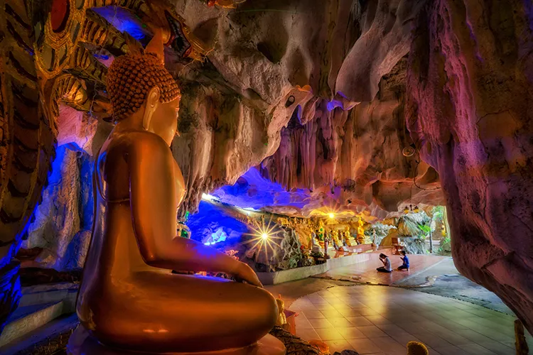
34. Wat Tham Khao Prathun is a Buddhist site surrounded by natural caves and mountainous terrain near Ban Khlong Yang in Khao Noi Subdistrict, Khao Chamao District. It is a good choice for travelers interested in combining religious visits with caves, forest scenery, and a quieter inland environment.
Highlights: Natural cave formations, limestone and rocky terrain, shaded forest surroundings, meditation areas, and access to the broader nature attractions of Khao Chamao District.
Inside the cave area, temperatures are noticeably cooler and humidity is higher than outside. Rock formations, cave passages, and shafts of natural light create a peaceful atmosphere suitable for slow exploration and contemplation.
Visitors should wear footwear suitable for uneven or damp surfaces, avoid touching or damaging cave formations, and follow all temple rules. Extra caution is advisable during the rainy season when conditions inside and around the caves can change.
Getting There: The temple is located at Ban Khlong Yang, Moo 4, Khao Noi Subdistrict, Khao Chamao District. Private vehicles provide the easiest access. Daytime visits are recommended, especially when entering the cave areas.
Map (GPS):Open Directions to Wat Tham Khao Prathun

35. Suchada Beach is a mainland beach near Rayong city that retains more of a local coastal-community atmosphere than a resort-oriented beach. The shoreline runs alongside a coastal road and includes fishing boats, seafood restaurants, and places where local residents gather by the sea.
Highlights: Local beach atmosphere, fishing community, seafood restaurants, casuarina trees, sunset views, and a convenient coastal connection between Saeng Chan Beach and Map Ta Phut.
Much of Suchada Beach’s appeal comes from the everyday life of the surrounding coastal community. Fishing boats and local activity can still be seen along the shore, making the area especially suitable for an evening seafood meal or a relaxed coastal stop.
Some sections of the coast include rock barriers or erosion-control structures, so visitors should choose swimming areas carefully and check sea conditions before entering the water.
Getting There: From Sukhumvit Road, turn toward the coastal roads in the Noen Phra–Map Ta Phut area and continue along the shoreline. Suchada Beach can easily be combined with Saeng Chan Beach and nearby western-coast attractions.
Map (GPS):Open Directions to Suchada Beach

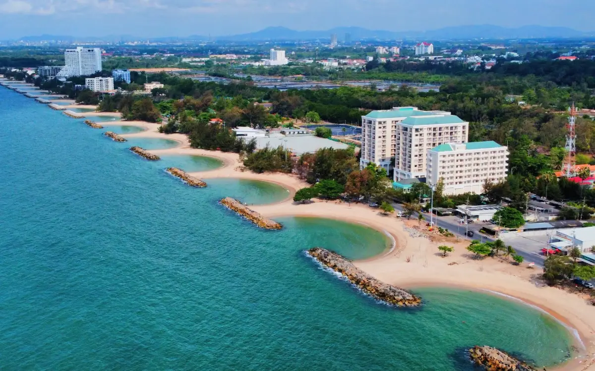
36. Saeng Chan Beach is located close to central Rayong and is easily recognized by its series of curved rock barriers designed to reduce coastal erosion. These structures create a succession of crescent-shaped beach sections, giving the shoreline a distinctive appearance unlike most other beaches in the province.
Highlights: Curved rock barriers, crescent-shaped beach sections, sunset viewpoints, local fishing activity, seafood restaurants, and convenient access from Rayong town.
Late afternoon is the best time to visit, when temperatures become more comfortable and sunset light spreads across the sea and rock barriers. The coastal road also provides convenient places to walk, sit, and enjoy the sea breeze.
Saeng Chan Beach can be combined in the same day with Phra Chedi Klang Nam, Suchada Beach, and Rayong Old Town, making it particularly suitable for travelers staying in central Rayong.
Getting There: Saeng Chan Beach is located in Pak Nam Subdistrict, Mueang Rayong District, about 5 kilometers from the city center. It is easily reached by the coastal road and is generally accessible throughout the day.
Map (GPS):Open Directions to Saeng Chan Beach

37. Wat Khot Thimtharam is an important historic temple in Tha Pradu, central Rayong. It has cultural and artistic value through its old ordination hall, religious architecture, and mural paintings that preserve Buddhist stories and local craftsmanship.
Highlights: Historic ordination hall, mural paintings illustrating the Ten Great Birth Stories of the Buddha, Luang Pho Khao Buddha image, old religious art, and a location close to Rayong Old Town.
The old ordination hall reflects the architectural character of historic temples in Thailand’s eastern coastal region. Some decorative elements show influences connected with Chinese trade and local craftsmanship, while the interior murals depict Buddhist narratives.
The temple fits naturally into a central Rayong heritage route and can be visited together with Yomjinda Road, Wat Pa Pradu, Wat Lum Mahachai Chumphon, and the King Taksin the Great Shrine.
Getting There: Wat Khot Thimtharam is located at 47/1 Sukhumvit Road, Tha Pradu Subdistrict, Mueang Rayong District. It is generally open daily from 06:00–19:30.
Map (GPS):Open Directions to Wat Khot Thimtharam

38. Suan Rukkhachart Phe (Suan Son) is a seaside recreation area on the Ban Phe–Laem Mae Phim coastal route. Its defining feature is a long line of casuarina trees running parallel to the beach, creating shade and a relaxed setting for picnics, walks, and family outings.
Highlights: Casuarina-lined coast, beach, scenic coastal road, picnic areas, seafood restaurants, and a convenient location linking Ban Phe with the coastline toward Klaeng District.
The arboretum functions both as a recreation area and as a coastal green space with trees adapted to the seaside environment. The casuarinas create shade along much of the road and give this section of coastline its familiar character.
Morning is pleasant for walking and sitting beneath the trees, while late afternoon is a good time to stop when traveling from Ban Phe toward Laem Mae Phim. Swimming may be possible when sea conditions are suitable.
Getting There: Suan Rukkhachart Phe is located along the Ban Phe–Laem Mae Phim coastal road in Phe Subdistrict, Mueang Rayong District. The arboretum area is generally open daily from 08:30–16:30, while the adjacent beach is publicly accessible.

39. Khao Yai Da Waterfall, sometimes locally referred to as the small weir waterfall, is a natural waterfall in Taphong Subdistrict, Mueang Rayong District. It lies within the forested Khao Yai Da area, an important watershed and agricultural zone close to the city.
Highlights: Forest stream, small natural cascades, clear pools, shaded surroundings, and easy access to nearby fruit orchards around Khao Yai Da.
The stream flows over rocks in a series of small levels, surrounded by large trees and dense vegetation. The area feels noticeably cooler than Rayong’s coastal zone, especially from the rainy season into the early cool season.
Khao Yai Da Waterfall can be combined with Suan Yai Da or other fruit orchards in Taphong, making the fruit season a particularly good time to experience both agricultural and natural attractions in the same area.
Getting There: From Rayong town, follow Sukhumvit Road toward Taphong and continue along local roads toward Khao Yai Da. During or after heavy rain, take extra care because trails and rocks may become slippery.
Map (GPS):Open Directions to Khao Yai Da Waterfall

40. Hat Sai Thong is located in the Map Ta Phut area of Mueang Rayong District and forms part of the western coastal route connected with Suchada Beach. The shoreline runs beside a coastal road and includes casuarina trees, sea views, and sections protected by rock structures.
Highlights: Approximately 5 kilometers of coastline, coastal road, casuarina trees, erosion-control rock barriers, and sunset viewpoints in the Map Ta Phut area.
Several sections of the coast include rock barriers constructed to reduce erosion. These structures create a landscape different from more natural beaches such as Mae Ramphueng or Laem Mae Phim and make Hat Sai Thong particularly suitable for coastal drives and landscape photography.
Hat Sai Thong can be combined with Suchada Beach and other western Rayong coastal areas, allowing visitors to follow the shoreline and stop at different viewpoints along the route.
Getting There: The beach is located in Map Ta Phut, Mueang Rayong District. From Sukhumvit Road, turn toward the Hat Sai Thong coastal road and continue toward the sea. The beach is publicly accessible throughout the day.
Map (GPS):Open Directions to Hat Sai Thong

41. Ao Lung Dam (Koh Samet) is a small bay in the southern part of Koh Samet, ideal for travelers who want to escape the island’s busier beaches. The shoreline combines sandy sections with natural rock formations, clear water, and a simple atmosphere that suits a quiet overnight stay or an unhurried day by the sea.
Highlights: Small peaceful beach, clear water, natural rocks, a pier extending into the sea, fishing spots, and a location close to Ao Sangthian.
Ao Lung Dam’s main appeal is its sense of privacy. Unlike Hat Sai Kaew, the area is not dominated by large-scale water activities or busy commercial zones. It is well suited to sitting by the sea, walking along the shore, swimming when conditions are calm, and enjoying the morning or evening light.
A wooden pier extending into the sea is another well-known feature and provides a good viewpoint over the bay. Visitors staying in this southern part of Koh Samet can also continue to nearby beaches on foot or by local transport, making the area a good choice for a slower island itinerary.
Getting There: From Na Dan Pier, take local transport south across Koh Samet, passing Wong Deuan Beach and Ao Sangthian before reaching Ao Lung Dam. The beach itself is accessible throughout the day.
Map (GPS):Open Directions to Ao Lung Dam

42. Laem Charoen Beach is a coastal area near Rayong city, located around Pak Nam and only a few kilometers from the urban center. Rather than being known primarily as a swimming beach, it is valued for its fishing-community atmosphere, seafood restaurants, piers, and views of everyday life along the Rayong coast.
Highlights: Traditional fishing community, seafood restaurants, small piers, Pak Nam coastal life, wave-protection structures, and sunset views close to the city.
Laem Charoen has long been connected with fishing and seafood production. Visitors can still see fishing boats and local activity around the shore, making the area a good place for a seafood meal and a relaxed walk rather than a beach day focused on swimming.
Late afternoon is especially pleasant, as visitors can enjoy the changing light over the coast before continuing to nearby Saeng Chan Beach or Phra Chedi Klang Nam, both of which lie within the same general city area.
Getting There: From central Rayong, travel toward Pak Nam Subdistrict and follow the coastal road to Laem Charoen. The area is generally accessible throughout the day.
Map (GPS):Open Directions to Laem Charoen Beach

43. Hat Laem Son is a quiet beach near Ban Laem Son in Pak Nam Krasae Subdistrict, Klaeng District. The shoreline retains the atmosphere of a fishing community near the river mouth and is better suited to relaxing beneath the trees, walking along the coast, and watching local life than to busy beach activities.
Highlights: Casuarina-lined coast, grayish natural sand, fishing-community atmosphere, picnic areas, views near the Krasae River mouth, and sunset scenery.
Some sections of the beach have darker sand caused by natural sediment, while certain parts are not ideal for swimming. The area is therefore best enjoyed for walking, photography, picnics, and observing fishing boats near the river mouth.
Nearby attractions include Pak Nam Krasae, Tung Prong Thong, and the Remembrance Lhuangprasae Battleship, making Hat Laem Son easy to include in a full-day route through eastern Klaeng without unnecessary backtracking.
Getting There: Travel from Laem Mae Phim or Klaeng toward Pak Nam Krasae Subdistrict, then continue to Ban Laem Son. The beach is publicly accessible throughout the day.
Map (GPS):Open Directions to Hat Laem Son

44. Hat Son Krasip is a public beach in the Map Ta Phut area, characterized by lines of casuarina trees along the coast. When sea breezes move through the branches, they create a soft whispering sound, which inspired the beach’s Thai name, often interpreted as “Whispering Pine Beach.”
Highlights: Casuarina trees, quiet shoreline, picnic areas, walking, photography, and a relatively natural coastal atmosphere within the Map Ta Phut area.
The shoreline extends for several hundred meters and includes both sandy sections and small rocky areas. At lower tide, the exposed beach becomes wider and more suitable for walking and sitting beneath the trees, especially in the late afternoon.
Sea conditions can vary with weather and season. Visitors planning to swim should check wave conditions carefully and avoid entering the water when the sea is rough or warnings are in place.
Getting There: Hat Son Krasip is located in the Map Ta Phut area and can be reached via Nong Fab Road and local coastal roads. The beach is publicly accessible throughout the day.
Map (GPS):Open Directions to Hat Son Krasip

45. Nong Pla Lai Reservoir is located around Ban Chak Malai in Pluak Daeng Subdistrict and is an important water resource in inland Rayong. It is also a pleasant recreation area for visitors who want open views of water, hills, and green surroundings instead of the province’s coastal scenery.
Highlights: Large reservoir, mountain views, dam area, cycling, walking, fishing, and sunset views in Pluak Daeng District.
The reservoir plays an important role in local water management and agriculture. At the same time, its open landscape and surrounding roads have made it a popular place for light exercise, recreation, and enjoying cooler air around the water.
Morning and late afternoon are the most comfortable periods for walking, running, or cycling. Near sunset, light reflecting across the water and distant hills creates one of the most attractive views in the area.
Getting There: The reservoir lies around Ban Chak Malai in Pluak Daeng District and can be combined with Dok Krai Reservoir on the same inland route. It is generally accessible during daylight hours.

46. Thai Mangosteen Garden (Khun Panya) is an agricultural tourism orchard in Nong Taphan Subdistrict, Ban Khai District. Despite its name, the orchard grows more than mangosteen, with durian, rambutan, longkong, mafai, and other seasonal tropical fruits also forming part of the landscape.
Highlights: Rayong mangosteen, durian, rambutan, longkong, seasonal fruit, orchard walks, and a chance to learn about fruit farming in Ban Khai District.
The main fruit season, generally around May to July depending on weather and harvest conditions, is the most rewarding time to visit. Travelers can observe different fruit trees in production and learn more about cultivation, orchard management, and harvesting.
Visitor activities and fruit-tasting arrangements depend on production in each season. Travelers planning a special visit should check whether the orchard is currently receiving visitors and which fruits are available.
Getting There: The orchard is located at Moo 4, Nong Taphan Subdistrict, Ban Khai District. Access is via Highway 3138 and connecting local roads. Visits are most relevant during Rayong’s main fruit season.

47. Phlong Ta Iem Fruit Market is a seasonal fruit market along the Ban Bueng–Klaeng route in Wang Chan District. It serves as a sales point for produce grown by farmers in the surrounding area, particularly durian, rambutan, mangosteen, and longkong.
Highlights: Rayong durian, mangosteen, rambutan, longkong, fresh fruit directly from growers, processed products, OTOP goods, and the atmosphere of a local fruit market during harvest season.
During the fruit season, the market becomes especially lively as farmers bring large quantities of produce for sale. It is a convenient option for travelers who want to buy fruit directly from the producing area without visiting several individual orchards.
The market may also feature processed foods and community products, reflecting the economic importance of fruit growing to Wang Chan District and Rayong Province as a whole.
Getting There: Phlong Ta Iem Fruit Market is located along the Ban Bueng–Klaeng road in Phlong Ta Iem Subdistrict, Wang Chan District. It operates mainly during the fruit season, with activity typically concentrated around the main harvest period.

48. Wat Chum Saeng is a community temple in Chum Saeng Subdistrict, Wang Chan District, with spacious grounds shaded by many Thai tree species. Its calm rural atmosphere makes it suitable for merit-making, quiet visits, and a cultural stop while exploring Rayong’s inland orchard areas.
Highlights: Shaded Thai-tree garden, peaceful temple grounds, ordination hall, bell tower, local wildlife, and the atmosphere of a rural Buddhist community in Wang Chan.
The temple grounds contain mature trees and extensive green space, giving the site a noticeably different atmosphere from temples in urban Rayong. Small wildlife, including jungle fowl, may occasionally be seen around the grounds.
The ordination hall and bell tower follow a relatively simple local style. Wat Chum Saeng is a useful cultural stop for travelers visiting orchards and fruit markets around Wang Chan who want to see more than agricultural attractions.
Getting There: Wat Chum Saeng is located in Moo 1, Chum Saeng Subdistrict, Wang Chan District. From Highway 344, follow local roads into the Chum Saeng area. The temple is generally open during daytime hours.
Map (GPS):Open Directions to Wat Chum Saeng

49. Wat Chongkho is an old temple in Wang Chan Subdistrict, conveniently located near Highway 344, the Ban Bueng–Klaeng route. Its roadside location makes it an easy stop while traveling through Wang Chan, and the temple remains an important center of local Buddhist faith.
Highlights: Luang Pho Phikun Thong, ordination hall, local religious art, chongkho trees, and the heritage of an established temple in Wang Chan District.
One of the temple’s important sacred images is Luang Pho Phikun Thong, which is highly respected by local residents. The temple grounds also contain religious buildings and features that reflect its long role as a community center.
When the chongkho trees are in bloom, pinkish-purple flowers add color to the temple surroundings, making it a pleasant stop between fruit orchards and other attractions in Wang Chan.
Getting There: Wat Chongkho is located in Moo 6, Wang Chan Subdistrict, Wang Chan District, close to Highway 344 on the Ban Bueng–Klaeng route. It is generally open during daytime hours.
Map (GPS):Open Directions to Wat Chongkho

50. OTOP Ma Yong is located along Highway 36 in Makham Khu Subdistrict, Nikhom Phatthana District. It is a convenient stop for travelers looking for local products and souvenirs from Rayong, especially before leaving the province or continuing toward Bangkok and neighboring destinations.
Highlights: Rayong OTOP products, fruit and processed foods, local snacks, handicrafts, souvenirs, and a convenient rest stop along Highway 36.
Products available at the center include fruit-based goods, processed food, local snacks, handicrafts, and community products from different parts of Rayong. This allows travelers to shop for several types of local products in one location.
The site also functions as a practical roadside stop with basic visitor facilities and space for activities, making it suitable for both independent travelers and larger groups. Its location along Highway 36 makes it a convenient final stop before leaving Rayong.
Getting There: OTOP Ma Yong is located at Moo 7, Highway 36, Makham Khu Subdistrict, Nikhom Phatthana District. It is generally open during daytime hours.
Map (GPS):Open Directions to OTOP Ma Yong
| Topic | Details |
| Rayong City Zone | 1. Rayong Old Town (Yomjinda Road) 2. Wat Pa Pradu 3. Phra Chedi Klang Nam 4. Nang Yai Wat Ban Don Museum 5. Wat Ban Laeng 6. Wat Lum Mahachai Chumphon 7. King Taksin the Great Shrine 8. Wat Khot Thimtharam 9. Saeng Chan Beach 10. Laem Charoen Beach Best for history, culture, temples, old-town walks, local food, and beaches close to central Rayong. |
| Mae Ramphueng–Khao Laem Ya–Ban Phe Zone | 1. Hat Mae Ramphueng 2. Khao Laem Ya - Mu Ko Samet National Park 3. Ban Phe 4. Suan Rukkhachart Phe (Suan Son) A good choice for mainland beaches, sunset views, seafood, souvenir shopping, and onward ferry travel to Koh Samet. |
| Koh Samet Zone | 1. Hat Sai Kaew 2. Wong Deuan Beach 3. Ao Phai 4. Ao Sangthian 5. Ao Lung Dam Best for swimming, kayaking, snorkeling, beachfront accommodation, island sunsets, and overnight seaside stays. |
| Klaeng–Laem Mae Phim–Pak Nam Krasae Zone | 1. Laem Mae Phim 2. Tung Prong Thong 3. Pak Nam Krasae 4. Sunthon Phu Monument 5. Remembrance Lhuangprasae Battleship 6. Rayong Botanical Garden 7. Hat Laem Son Ideal for beaches, mangrove forests, literature, fishing communities, seafood, and coastal nature. |
| Khao Chamao Zone | 1. Khao Chamao-Khao Wong National Park 2. Khao Chamao Waterfall 3. Klong Pla Kang Waterfall 4. Wat Tham Khao Prathun Best for forests, waterfalls, hiking, caves, and travelers who want to experience Rayong beyond its beaches. |
| Taphong–Khao Yai Da Zone | 1. Suan Yai Da (Jae Boonchuen) 2. Phanan Orchard 3. Khao Yai Da Waterfall Best during fruit season for orchard visits, durian, mangosteen, rambutan, and nearby nature attractions. |
| Ban Khai Zone | 1. Wat Laharn Rai 2. Wat Wai Krong 3. Thai Mangosteen Garden (Khun Panya) A good route for Buddhist heritage, historic temples, respected monks, and agricultural tourism. |
| Wang Chan Zone | 1. Chum Saeng Durian Orchards 2. Phlong Ta Iem Fruit Market 3. Wat Chum Saeng 4. Wat Chongkho Best during the fruit season for orchard landscapes, locally grown produce, rural communities, and temple visits. |
| Pluak Daeng Zone | 1. Dok Krai Reservoir 2. Rayong Agricultural Occupation Promotion and Development Center 3. Nong Pla Lai Reservoir Suitable for reservoir views, cycling, sunset watching, and agricultural learning. |
| Nikhom Phatthana Zone | 1. Princess Maha Chakri Sirindhon Herbal Garden 2. OTOP Ma Yong Suitable for learning about Thai medicinal plants and shopping for Rayong community products and souvenirs. |
| Ban Chang Zone | 1. Nam Rin Beach 2. Hat Phayun and Hat Phla Best for quieter beaches, sunset views, seafood, and exploring Rayong’s western coastline. |
| Map Ta Phut–Western Coast Zone | 1. Suchada Beach 2. Hat Sai Thong 3. Hat Son Krasip Suitable for scenic coastal drives, local seaside atmosphere, sunset views, and relaxed stops along western Rayong. |
| Best for Beaches and Islands | 1. Hat Sai Kaew 2. Hat Mae Ramphueng 3. Laem Mae Phim 4. Wong Deuan Beach 5. Ao Phai 6. Ao Sangthian 7. Ao Lung Dam 8. Nam Rin Beach 9. Hat Phayun and Hat Phla 10. Saeng Chan Beach 11. Laem Charoen Beach 12. Suchada Beach 13. Hat Laem Son 14. Hat Sai Thong 15. Hat Son Krasip |
| Best for Nature | 1. Khao Laem Ya - Mu Ko Samet National Park 2. Tung Prong Thong 3. Khao Chamao-Khao Wong National Park 4. Khao Chamao Waterfall 5. Klong Pla Kang Waterfall 6. Rayong Botanical Garden 7. Khao Yai Da Waterfall 8. Dok Krai Reservoir 9. Nong Pla Lai Reservoir |
| Best for History and Culture | 1. Rayong Old Town (Yomjinda Road) 2. Phra Chedi Klang Nam 3. Sunthon Phu Monument 4. Remembrance Lhuangprasae Battleship 5. Nang Yai Wat Ban Don Museum 6. Wat Ban Laeng 7. Wat Lum Mahachai Chumphon 8. King Taksin the Great Shrine 9. Wat Khot Thimtharam |
| Best for Temples and Spiritual Travel | 1. Wat Pa Pradu 2. Wat Lum Mahachai Chumphon 3. King Taksin the Great Shrine 4. Wat Ban Laeng 5. Wat Laharn Rai 6. Wat Wai Krong 7. Wat Khot Thimtharam 8. Wat Tham Khao Prathun 9. Wat Chum Saeng 10. Wat Chongkho |
| Best for Fruit Orchards and Agriculture | 1. Suan Yai Da (Jae Boonchuen) 2. Phanan Orchard 3. Chum Saeng Durian Orchards 4. Thai Mangosteen Garden (Khun Panya) 5. Phlong Ta Iem Fruit Market 6. Rayong Agricultural Occupation Promotion and Development Center |
| Recommended for Families | Hat Mae Ramphueng, Khao Laem Ya - Mu Ko Samet National Park, Ban Phe, Suan Rukkhachart Phe, Rayong Botanical Garden, Princess Maha Chakri Sirindhon Herbal Garden, Suan Yai Da, and Dok Krai Reservoir offer a good mix of easy sightseeing, outdoor activities, and educational experiences for different age groups. |
| Recommended for Older Travelers | Wat Pa Pradu, Rayong Old Town, Wat Lum Mahachai Chumphon, King Taksin the Great Shrine, Ban Phe, Laem Mae Phim, and Princess Maha Chakri Sirindhon Herbal Garden are generally easier to visit than long waterfall or mountain trails. |
| Recommended for Couples | Koh Samet, Wong Deuan Beach, Ao Phai, Ao Sangthian, Laem Mae Phim, Khao Laem Ya, and Saeng Chan Beach are good choices for seaside stays, sunset views, and relaxed 2–3 day trips. |
| 1-Day Itinerary | Morning: Wat Pa Pradu – Rayong Old Town (Yomjinda Road) – Wat Lum Mahachai Chumphon Afternoon: Phra Chedi Klang Nam – Hat Mae Ramphueng Evening: Khao Laem Ya - Mu Ko Samet National Park – Ban Phe |
| 2 Days / 1 Night | Day 1: Rayong town – Yomjinda Road – Wat Pa Pradu – Hat Mae Ramphueng – Khao Laem Ya – Ban Phe Day 2: Koh Samet – Hat Sai Kaew – Ao Phai – Wong Deuan Beach |
| 3 Days / 2 Nights | Day 1: Rayong town – Hat Mae Ramphueng – Khao Laem Ya Day 2: Koh Samet Day 3: Laem Mae Phim – Sunthon Phu Monument – Tung Prong Thong – Pak Nam Krasae – Remembrance Lhuangprasae Battleship |
| 4 Days / 3 Nights | Day 1: Rayong town and nearby coastline Day 2: Koh Samet Day 3: Laem Mae Phim – Pak Nam Krasae – Tung Prong Thong Day 4: Khao Chamao-Khao Wong National Park – Khao Chamao Waterfall – Klong Pla Kang Waterfall |
| 5 Days / 4 Nights | A good option for travelers who want a complete Rayong experience. Spend one day in Rayong town, one day on Koh Samet, one day around Klaeng and Pak Nam Krasae, one day in Khao Chamao, and one day exploring Wang Chan, Ban Khai, Pluak Daeng, or the Taphong fruit-orchard area depending on the season. |
| Best Overall Travel Period | The cooler months toward the end and beginning of the year are comfortable for outdoor sightseeing. Beach and island conditions should always be assessed according to the actual weather and sea conditions on the travel date. |
| Best Time for Koh Samet and Beaches | Choose days with calm sea conditions and no marine warnings. Check weather forecasts, boat schedules, and notices from Khao Laem Ya - Mu Ko Samet National Park before traveling, especially when planning boat trips or marine activities. |
| Best Time for Waterfalls | The rainy season through the early cool season usually provides greener forest scenery and stronger water flow at Khao Chamao Waterfall, Klong Pla Kang Waterfall, and Khao Yai Da Waterfall. Always check for heavy-rain, flash-flood, or trail warnings before visiting. |
| Best Time for Fruit Orchards | Rayong’s fruit season is the best time to visit Suan Yai Da, Phanan Orchard, Thai Mangosteen Garden, Chum Saeng Durian Orchards, and Phlong Ta Iem Fruit Market. Durian, mangosteen, rambutan, and longkong reach harvest at different times each year, so check current orchard conditions before traveling. |
| Getting Around Rayong | Local transport and taxis can cover central Rayong, Ban Phe, and some nearby areas, but attractions are spread across Ban Chang, Pluak Daeng, Wang Chan, Khao Chamao, Klaeng, and Pak Nam Krasae. A private car, rental car, or hired vehicle with a driver is the most practical option for multi-zone trips. Koh Samet requires a boat connection from the Ban Phe area. |
| Local Food to Try | Moo Chamuang, noodles with mantis shrimp, spicy phak krachap salad, sour curry with crab, fresh seafood, local fish dishes, and seasonal Rayong fruits are among the foods worth trying. |
| Best Seafood Areas | Ban Phe, Hat Mae Ramphueng, Saeng Chan Beach, Laem Charoen Beach, Laem Mae Phim, and Pak Nam Krasae are convenient areas for combining sightseeing with seafood meals. |
| Popular Souvenirs | Seasonal durian, mangosteen and rambutan, processed fruit products, dried seafood, dried fish and squid, fish sauce, shrimp paste, and Rayong OTOP products are popular choices. |
| Where to Stay: Rayong Town | Best for travelers focusing on Yomjinda Road, Wat Pa Pradu, Phra Chedi Klang Nam, Saeng Chan Beach, and restaurants in central Rayong. Hat Mae Ramphueng is also within convenient driving distance. |
| Where to Stay: Mae Ramphueng–Ban Phe | A practical base for mainland beach stays, Khao Laem Ya, and early-morning ferry connections to Koh Samet. |
| Where to Stay: Koh Samet | Hat Sai Kaew is best for convenience, restaurants, and a lively atmosphere. Wong Deuan Beach combines good facilities with a more relaxed setting, while Ao Sangthian and Ao Lung Dam are better for travelers seeking greater peace and privacy. |
| Where to Stay: Laem Mae Phim–Klaeng | Recommended for travelers planning to visit Laem Mae Phim, the Sunthon Phu Monument, Rayong Botanical Garden, Tung Prong Thong, and Pak Nam Krasae without driving back to Rayong town each day. |
| Sea Safety | Check weather and wave conditions before boat trips or swimming. Follow beach-warning flags and official instructions, avoid entering rough water, and supervise children closely near the sea. |
| Waterfall and Forest Safety | Watch for slippery rocks, avoid streams during heavy rain or when water levels rise quickly, stay on marked trails, and follow instructions from national park staff. |
| Visiting Fruit Orchards Responsibly | Follow the routes established by orchard owners, do not pick fruit without permission, and check current opening arrangements, fruit availability, and visitor programs before traveling. |
| Responsible Travel | Do not leave rubbish on beaches, in mangroves, waterfalls, or forests. Avoid touching or collecting marine life and coral, stay on designated trails in protected areas, dress respectfully at temples, and support local restaurants, orchards, markets, and community products. |
Frequently Asked Questions (FAQ)
Q: What are the must-visit places in Rayong?
A: For a first trip, consider Koh Samet, Hat Sai Kaew, Khao Laem Ya - Mu Ko Samet National Park, Hat Mae Ramphueng, Laem Mae Phim, Tung Prong Thong, Pak Nam Krasae, Rayong Old Town, and Wat Pa Pradu. Together they cover beaches, islands, nature, history, culture, and local communities.
Q: What should I visit in Rayong if I only have one day?
A: Focus on the Rayong town–Ban Phe route. Start with Wat Pa Pradu and Yomjinda Road, continue to Phra Chedi Klang Nam and Hat Mae Ramphueng, then finish the afternoon or evening at Khao Laem Ya and Ban Phe.
Q: How many days should I spend in Rayong?
A: Two to three days are enough for Rayong town, Ban Phe, Koh Samet, and Laem Mae Phim. Four to five days are better if you also want to explore Pak Nam Krasae, Khao Chamao, fruit orchards, Wang Chan, Ban Khai, and Pluak Daeng.
Q: Which area is best for first-time visitors to Rayong?
A: Rayong town, Hat Mae Ramphueng, Khao Laem Ya, Ban Phe, and Koh Samet form the easiest first-time route because several of the province’s best-known attractions can be connected efficiently.
Q: How many nights should I stay on Koh Samet?
A: At least one night is recommended so you can experience the island after many day visitors have left. Two nights are better if you want to explore several beaches and spend more time relaxing by the sea.
Q: Which Rayong beaches are good for families?
A: Hat Mae Ramphueng, Laem Mae Phim, Suan Son, and selected beaches on Koh Samet are popular family choices. Always check wave conditions and local safety warnings before swimming.
Q: Where can I visit the sea in Rayong without going to Koh Samet?
A: Mainland options include Hat Mae Ramphueng, Khao Laem Ya, Suan Son, Laem Mae Phim, Saeng Chan Beach, Laem Charoen Beach, Nam Rin Beach, Hat Phayun, Hat Phla, Suchada Beach, and Hat Laem Son.
Q: What is the best time of day to visit Tung Prong Thong?
A: Morning and late afternoon are usually the most attractive because angled sunlight brings out the green and golden tones of the prong-tree canopy and temperatures are more comfortable than at midday.
Q: What are the best waterfalls in Rayong?
A: Khao Chamao Waterfall, Klong Pla Kang Waterfall, and Khao Yai Da Waterfall are among the main options. Khao Chamao is especially notable for its multiple levels and forest trail.
Q: When is the best time to visit Rayong fruit orchards?
A: Visit during Rayong’s main fruit season, when durian, mangosteen, rambutan, and longkong are available. Harvest timing varies each year, so checking directly with the orchard before traveling is recommended.
Q: Which fruit orchards in Rayong are worth visiting?
A: Suan Yai Da, Phanan Orchard, Thai Mangosteen Garden, and the durian orchards around Wang Chan are good options for experiencing Rayong’s fruit-growing culture.
Q: What historical attractions are there in Rayong?
A: Rayong Old Town, Phra Chedi Klang Nam, Wat Lum Mahachai Chumphon, King Taksin the Great Shrine, Wat Khot Thimtharam, and the Remembrance Lhuangprasae Battleship represent different periods of Rayong’s history.
Q: What are the most important temples in Rayong?
A: Wat Pa Pradu, Wat Lum Mahachai Chumphon, Wat Laharn Rai, Wat Ban Laeng, Wat Wai Krong, and Wat Khot Thimtharam are among the province’s notable temples for religious, historical, and artistic significance.
Q: What local food should I try in Rayong?
A: Try Moo Chamuang, noodles with mantis shrimp, spicy phak krachap salad, sour curry with crab, fresh seafood, local fish dishes, and seasonal Rayong fruits.
Q: Where should I buy souvenirs in Rayong?
A: Ban Phe is convenient for dried seafood, fish sauce, shrimp paste, and marine products. Taphong and Wang Chan are good for fresh fruit and processed fruit products, while OTOP Ma Yong offers a range of community-made products in one location.
Q: Is Rayong suitable for family trips?
A: Yes. Rayong offers beaches, national parks, botanical gardens, herbal gardens, fruit orchards, communities, and educational attractions, making it possible to plan activities for children, adults, and older travelers in the same trip.
Q: Can I travel around Rayong without a private car?
A: Central Rayong, Ban Phe, and Koh Samet can be visited using local transport and taxis. However, a private car, rental car, or hired driver is much more practical for Klaeng, Pak Nam Krasae, Khao Chamao, Wang Chan, Ban Khai, Pluak Daeng, and other inland areas.
Q: How should I plan a Rayong route without unnecessary backtracking?
A: Divide the province into travel zones: Rayong town–Mae Ramphueng–Ban Phe, Koh Samet, Klaeng–Laem Mae Phim–Pak Nam Krasae, Khao Chamao, Wang Chan, Ban Khai–Pluak Daeng, and Ban Chang–western coast. Complete one zone before moving to the next.
Q: What is the best season to visit Rayong?
A: The cooler months are comfortable for general sightseeing, while beach trips depend on calm sea conditions. Fruit orchards are best during harvest season, and waterfalls are most attractive from the rainy season into the early cool season, provided conditions are safe.
 Category: ●Travel Articles, Recipes
 Group: ●Travel Review, Food Review
Last Update : 3 WeekAgo
 Last Update : 3 WeekAgo
Recommend

 Art, Culture and Heritage
 Landmarks and Memorials(3)
 Art, Craft Centres, Tradition(2)
 Museums(3)
 Educational Places
 Educational Gardens, Farm(2)
 Places of Worship
 Temple(34)
 Other Sacred Sites(8)
 Research and Development
 Royal Project(1)
 Suburban Living
 Village, Community(2)
 Local Market(3)
 Nature and Wildlife
 National Parks and Marine Reserves(2)
 Mountain (Doi)(2)
 Dam, Reservoir, Lake(5)
 Waterfalls(4)
 River, Canal(1)
 Bays and Beaches(27)
 Islands(8)
 Other natural attractions(4)
 Entertainment and Agricultural
 Zoos and Aquariums(1)
 Farms, Parks and Ecotourism(16)
 Outdoor and Adventure Activities(2)
 Shopping
 Shopping and Night Market(1)
Travel Review, Food Review(1)


