
lovethailand home >Central Travel Attractions >Saraburi Travel Attractions > 30 Best Places to Visit in Saraburi Central Thaila..
TL;DR: 30 Best Places to Visit in Saraburi Central Thailand, open Daily Opening Hours: 07:00 – 17:00.
30 Best Places to Visit in Saraburi Central Thailand
30 Best Places to Visit in Saraburi, Central Thailand Saraburi is a Central Thailand destination near Bangkok with far more variety than its reputation as a transit province might suggest. Within one province, travelers can explore nationally important Buddhist sites, waterfalls, national parks, the Dong Phayayen forest landscape, caves, archaeological sites, historic railway routes, agritourism attractions, and communities with long histories. Highlights for first-time visitors include Wat Phra Phutthabat Ratchaworamahawihan, Namtok Chet Sao Noi National Park, Namtok Sam Lan National Park, Wat Phra Phutthachai, the Thai-Danish Dairy Farm, Wat Pa Sawang Bun, and the natural areas around Kaeng Khoi and Muak Lek. Travelers with only 1 day should focus on one zone such as Phra Phutthabat, central Saraburi, or Muak Lek, while 2–3 days allow temples, history, waterfalls, forests, and educational attractions to be combined more comfortably.
Saraburi lies in the northern part of Central Thailand and serves as an important gateway between Bangkok, the upper Central Region, the Northeast, and the Dong Phayayen mountain range. Its landscape changes markedly from plains and urban communities along the Pa Sak River basin to mountains, forests, caves, and headwater areas around Kaeng Khoi, Muak Lek, and the forests adjoining Khao Yai. This diversity makes it possible to combine cultural and natural attractions within the same province.
Historically and religiously, Saraburi is especially important because of Wat Phra Phutthabat Ratchaworamahawihan, home to the revered Buddha Footprint on Suwan Banphot Hill and a major pilgrimage center since the Ayutthaya period. The wider Phra Phutthabat area also contains archaeological remains, royal residences, and sites associated with historic royal pilgrimage routes, making the district worth exploring beyond a brief temple visit.
Another important area is Wat Phra Phutthachai and Khao Pathawi, where Buddhist faith is combined with archaeological evidence, prehistoric rock art, and rocky mountain terrain. Tham Phra Phothisat Cave in Kaeng Khoi also preserves religious bas-reliefs that reflect historical interaction between Buddhist and Brahmanical-Hindu beliefs. These sites make Saraburi particularly suitable for travelers who want to understand history through real landscapes and surviving evidence.
For nature lovers, Saraburi has both Namtok Sam Lan National Park and Namtok Chet Sao Noi National Park, each with a distinct character. Sam Lan offers forested hills and nature trails close to the city, while Chet Sao Noi is known for a stream descending through several low waterfall tiers that are relatively easy to access. Chet Khot–Pong Kon Sao Nature Study and Ecotourism Center connects with the western forest of Khao Yai and is suitable for visitors interested in hiking, birdwatching, camping, and more serious ecological exploration.
Muak Lek is another major tourism zone because it combines nature, agriculture, and the history of Thailand’s dairy industry. The Thai-Danish Dairy Farm is closely connected with the beginnings of modern dairy farming in Thailand, while Muak Lek Arboretum offers streams, small waterfalls, a suspension bridge, and a wide variety of trees. The Muak Lek area is therefore particularly suitable for families, children, students, and travelers seeking outdoor activities that are not overly strenuous.
Kaeng Khoi has a different character, combining mountains, forests, caves, religious sites, and railway history. Railway lines cutting through the Dong Phayayen landscape created historically important locations such as Pha Sadet and the Phra Phutthachai Railway Tunnel. Meanwhile, the Cha-om and Tha Maprang areas are home to Wat Pa Sawang Bun and Chet Khot–Pong Kon Sao, allowing travelers to combine temple visits, photography, hiking, and overnight nature trips.
Saraburi’s food and souvenir culture is closely linked with agriculture and livestock. Dairy products from Muak Lek are among the province’s best-known products, while local food, seasonal farm produce, and community products can be found around markets and tourism areas. During the cool season, sunflower fields in several districts also create bright yellow landscapes that have become another familiar image of Saraburi and the neighboring Lopburi border area.
Getting There: Travel from Bangkok to Saraburi is convenient by car via Phahonyothin Road or Mittraphap Road, depending on the destination. For Phra Phutthabat attractions, plan a route through Phra Phutthabat District. For nature trips, it is more efficient to divide the province into the Sam Lan–Phra Phutthachai zone, Kaeng Khoi–Cha-om zone, and Muak Lek–Chet Sao Noi zone. Grouping attractions geographically reduces backtracking and allows more time at each destination.
Saraburi can be visited throughout the year, although activities vary by season. The rainy season is best for waterfalls and green forests, while the late rainy season through winter is better for hiking, outdoor sightseeing, and seasonal agricultural landscapes. Travelers with 4–5 days can spread their trip across Wang Muang, Kaeng Khoi, Muak Lek, Phra Phutthabat, and natural attractions around central Saraburi for a much more complete experience than a simple day trip.

1. Wat Phra Phutthabat Ratchaworamahawihan is located in Khun Khlon Subdistrict, Phra Phutthabat District. It is a first-class royal monastery of the Ratchaworamahawihan type and one of Thailand’s most important Buddhist pilgrimage sites. The spiritual center of the temple is the Buddha Footprint on the slope of Suwan Banphot Hill, which has been venerated since the Ayutthaya period. The site is therefore significant in religion, history, art, architecture, and the long tradition of Buddhist pilgrimage.
Highlights: Buddha Footprint on Suwan Banphot Hill, Phra Phutthabat Mondop, first-class royal-monastery status, the legend of Hunter Bun, architectural and artistic elements from several periods, the Phra Phutthabat pilgrimage festival, and important archaeological sites around Phra Phutthabat District.
The discovery of the Buddha Footprint is traditionally associated with the reign of King Songtham of Ayutthaya. According to the story, monks from Siam traveled to Lanka to worship the sacred footprint on Sumanakuta Mountain and were told that Siam itself also had a Buddha Footprint. A search eventually led to the discovery of the footprint on Suwan Banphot Hill in Saraburi.
The legend of Hunter Bun is closely associated with the site. It tells of a hunter who followed an injured animal and discovered a depression in the rock filled with water. Events surrounding the discovery led people to believe that the location was sacred. After the information reached local authorities and the royal court, the site was examined and structures were built to protect and honor the footprint.
The mondop covering the Buddha Footprint is the central destination for visitors. Inside is the revered footprint itself, while the surrounding temple complex contains buildings, shrines, and artistic elements resulting from centuries of royal patronage, restoration, and religious activity. Visitors should therefore allow enough time to explore the wider complex rather than simply climbing to the footprint and leaving immediately.
The temple’s continuing importance is also seen in the long-standing Phra Phutthabat pilgrimage festival, when large numbers of Buddhist devotees come to worship and take part in religious activities. For centuries, the Phra Phutthabat area has functioned as a center of pilgrimage, trade, community life, and movement.
Families and older visitors should allow extra time for the stairway and rest as needed. History enthusiasts can continue to nearby royal residences and archaeological sites in Phra Phutthabat District, while Buddhist travelers can build an entire day around the sacred sites in this area.
Open Days: Daily Opening Hours: 07:00 – 17:00
Getting There: From Bangkok, take Phahonyothin Road toward Saraburi and continue into Phra Phutthabat District following signs for Wat Phra Phutthabat Ratchaworamahawihan. A private car is convenient for combining the temple with other historical and religious attractions in the same zone.

2. Namtok Chet Sao Noi National Park is located in Muak Lek Subdistrict, Muak Lek District, and is one of Saraburi’s most popular natural attractions. Its main feature is a stream flowing over 7 low limestone cascades, forming rocky terraces, natural pools, and riverside resting areas that are relatively easy to access. It is suitable for families, groups of friends, and travelers who want a nature trip without a long mountain hike.
Highlights: 7 waterfall tiers, Muak Lek Stream, turquoise-green water under suitable conditions, limestone cascades, natural pools, picnic areas, nature walks, and a shaded forest atmosphere relatively close to Bangkok.
The waterfall differs from tall cliff waterfalls because each tier is relatively low, generally around 2–5 meters. Water flows over broad limestone terraces and forms several wide pools, creating a relaxed atmosphere that is more suitable for streamside recreation than for climbing steep terrain to reach a major drop.
The national park covers parts of Muak Lek District in Saraburi and extends into part of Pak Chong District in Nakhon Ratchasima. The area was originally established as Chet Sao Noi Waterfall Forest Park before later being developed into a national park with more systematic conservation, tourism management, and visitor facilities.
Muak Lek Stream is central to the landscape. The water passes through forest and limestone formations before descending through several levels. Water color and clarity vary with the season, rainfall, and natural conditions, so visitors should pay attention to official notices, especially during heavy rain or periods of strong current.
Swimming is possible in certain sections when conditions are safe, but visitors should use only areas permitted by park staff and avoid deep water or strong currents. Families with children should supervise them closely even though the waterfall is easier to access than many larger falls.
The park combines well with the Thai-Danish Dairy Farm and other Muak Lek attractions. Travelers staying 1 night in Muak Lek can spend the first day on family and agricultural activities, then use the second day for Chet Sao Noi and Muak Lek Arboretum without extensive backtracking.
Open Days: Daily Opening Hours: 08:00 – 17:00
Getting There: From Bangkok, take Mittraphap Road toward Muak Lek District, then continue on local roads following signs for Namtok Chet Sao Noi National Park. A private car is the most convenient option for combining multiple Muak Lek attractions.

3. Namtok Sam Lan National Park is an important protected forest area near central Saraburi. It contains rugged hills, mixed deciduous forest, dry dipterocarp forest, waterfalls, nature trails, and forest recreation areas. Its main advantage is that visitors can experience nature without traveling far from Bangkok, making it suitable for day trips, families, and travelers beginning to explore Thailand’s national parks.
Highlights: Sam Lan Waterfall, forest close to the city, mountainous terrain, mixed deciduous and dry dipterocarp forests, nature-study trails, recreation areas, and convenient proximity to Wat Phra Phutthachai.
The park covers parts of several Saraburi districts and has an area of approximately 44.57 square kilometers. Its value extends beyond recreation because it also serves as an important green area and watershed supporting ecological diversity close to urban communities.
The conservation history of the area is relatively long. It began as a forest park before being declared a national park in 1981. For a period it was renamed Phra Phutthachai National Park before later returning to the name Namtok Sam Lan National Park, which remains the name most familiar to visitors.
The landscape consists of hills and forested headwaters feeding several streams. Sam Lan Waterfall is therefore part of a wider forest-water system rather than an isolated tourist feature. Travelers walking the nature trails can observe differences in vegetation, rock formations, and forest conditions along the route.
Water volume changes significantly by season. During rainy periods the forest becomes greener and the waterfall more impressive, but visitors must also monitor safety announcements when rainfall is heavy. Footwear with good traction is recommended, and visitors should avoid strong currents and slippery rock surfaces.
The park lies close to Wat Phra Phutthachai, making it easy to combine the two in a half-day or full-day trip. Visitors can begin with worship and archaeology at the temple and continue into the national park, or reverse the order depending on weather conditions.
Open Days: Daily Opening Hours: 08:00 – 18:00
Getting There: From central Saraburi, travel toward Nong Pla Lai Subdistrict on the road leading to Namtok Sam Lan National Park. The area connects conveniently with the Wat Phra Phutthachai zone and is best reached by private vehicle.

4. Wat Phra Phutthachai lies at the foot of Khao Pathawi in Nong Pla Lai Subdistrict. It combines religious, historical, archaeological, and natural importance in one location. Its best-known feature is the “Phra Phutthachai,” a sacred Buddha-like impression on the rock face, protected by a mondop and revered by generations of Buddhist visitors.
Highlights: Phra Phutthachai on the cliff, Phra Phutthachai Mondop, Buddha Footprint, prehistoric rock drawings, Khao Pathawi, cliffside routes, and proximity to Namtok Sam Lan National Park.
The Phra Phutthachai distinguishes the temple from ordinary Buddhist sites because the sacred image appears directly on the natural rock face. The mondop was constructed to cover and preserve it. Visitors reach the shrine by climbing steps from the lower temple area, and additional routes lead higher up the hill for wider views of the surrounding landscape.
Archaeology is another major reason to visit. Prehistoric line drawings have been found around the base of the cliff, including animal figures, human hands, and symbolic markings, as well as drawings along the route from Ruesi Cave toward Phra Phutthachai. These remains show that Khao Pathawi had human significance long before the later development of the Buddhist sanctuary.
Some drawings are believed to be several thousand years old, providing evidence of ancient beliefs and human use of the landscape. Combined with the Buddhist sacred image and present-day temple, the mountain contains multiple layers of history from different periods.
The area also contains a Buddha Footprint discovered during renovation of the mondop in 1994, further increasing the site’s religious significance. Buddhist visitors can therefore worship at several sacred points, while archaeology enthusiasts have much more to study than the Phra Phutthachai alone.
The temple is very close to Namtok Sam Lan National Park, making the two easy to combine in one trip. Visitors climbing higher areas should wear suitable footwear for stairs and rocky surfaces and dress respectfully because the site remains an active religious area.
Open Days: Daily Opening Hours: 08:00 – 17:00
Getting There: From central Saraburi, follow the road toward Namtok Sam Lan National Park and continue onto the same route serving Wat Phra Phutthachai. Signs are available along the way, and a private car makes it easy to continue directly to the national park.
Map (GPS):Open Google Maps – Wat Phra Phutthachai

5. Thai-Danish Dairy Farm is located in Mittraphap Subdistrict, Muak Lek District. It is one of Thailand’s most historically important agritourism attractions because it is closely linked to the development of modern dairy farming in the country. Visitors can learn about the history of Thailand’s dairy industry, farm management, dairy-cattle care, and milk-production activities in a working agricultural environment.
Highlights: History of the Thai-Danish Dairy Farm, dairy-cattle husbandry, farm tours, calf and milking activities, milk production and processing, museum exhibits, and dairy-product shops.
The farm’s history is rooted in cooperation between Thailand and Denmark following a royal visit to Denmark in 1960. The Thai-Danish Dairy Farm was subsequently developed and officially opened on January 16, 1962. Muak Lek therefore became an important center in the development of dairy farming and Thailand’s modern dairy industry.
The farm began opening its facilities more systematically to general visitors for agritourism in 2007. Travelers are therefore able to see more than just production areas and can understand the entire journey of milk from cattle care and farm management to processing and finished products.
The activities are particularly suitable for children and families because agriculture and livestock management become tangible experiences. Seeing calves, milking processes, or demonstrations helps visitors understand that everyday dairy products pass through many stages before reaching consumers.
The historical dimension also gives the farm value beyond family recreation. Adults and visitors interested in the history of Thai agriculture can easily spend half a day here without feeling that the attraction is limited to viewing animals.
The farm is located along the Mittraphap Road corridor and close to several Muak Lek natural attractions. It combines well with Muak Lek Arboretum and Namtok Chet Sao Noi National Park, making it suitable for a 1-day family trip or an overnight stay in Muak Lek.
Open Days: Daily Opening Hours: 08:30 – 16:30
Getting There: The farm is located near the entrance to Muak Lek District along Mittraphap Road. From Bangkok, follow Mittraphap Road toward Muak Lek and then follow signs for the Thai-Danish Dairy Farm.
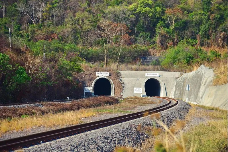
6. Phra Phutthachai Railway Tunnel lies around Khao Chong Ling near the boundary between Charoen Tham Subdistrict in Wihan Daeng District and Nong Pla Lai Subdistrict in Mueang Saraburi District. It combines railway history, engineering, mountain scenery, and photography in one location. The tunnel remains part of an active railway, giving it both infrastructural significance and a distinctive visual setting.
Highlights: Single-track railway tunnel approximately 1,197 meters long, arched tunnel entrance, railway line cutting through the mountain, Khao Chong Ling scenery, railway engineering, and photography combining industrial structures with nature.
The tunnel is approximately 7 meters wide and high and extends for about 1,197 meters. It was built around 1994 and required tunneling through mountainous terrain to develop the railway route, making it interesting for visitors who enjoy infrastructure and transport history.
From the tunnel entrance, the rails lead into darkness through an arched frame surrounded by forested mountain scenery. This composition has made the location popular with photographers, especially those who enjoy strong leading lines and cinematic landscapes.
Safety is the most important consideration because trains still use the line. Visitors should not walk deep into the tunnel or stand on the tracks for photographs. Always remain alert for train signals and sounds, and avoid the railway entirely when visibility is poor.
This is not a commercial attraction with extensive visitor facilities. Its appeal lies in the simplicity of the tunnel and surrounding mountain terrain. Visitors should bring drinking water, a hat, suitable footwear, and remove all rubbish from the area.
The tunnel is not far from Namtok Sam Lan National Park and Wat Phra Phutthachai, so it can be incorporated into a 1-day route focused on nature, history, and photography.
Getting There: From central Saraburi, follow the road toward Wat Phra Phutthachai or Namtok Sam Lan National Park, then continue toward the Khao Chong Ling area. A private car is the most convenient option because the site is away from major urban areas.

7. Tham Phra Phothisat Cave is located within Wat Tham Phra Phothisat in Thap Kwang Subdistrict, Kaeng Khoi District. It has natural, religious, and archaeological value. The large limestone cave contains stalactites, stalagmites, and ancient bas-reliefs on the cave wall showing Buddhist scenes alongside Hindu deities.
Highlights: Limestone cave, relief of the Buddha teaching disciples, Hindu deity figures, stalactites and stalagmites, historical traces, and the “Ch.P.R.” royal monogram associated with King Chulalongkorn.
The cave has a quiet and solemn atmosphere. Its stalactites and stalagmites developed over long periods of natural geological formation, while evidence of past human activity shows that the mountain and cave were historically used for religion and belief as well as being natural features.
The wall reliefs are among the most important elements inside the cave. They include a representation of the Buddha teaching disciples and figures from Brahmanical-Hindu belief. Their coexistence reflects historical interaction and blending between religious traditions in ancient society.
Outside the cave, the shaded natural surroundings also contain a “Ch.P.R.” monogram associated with King Chulalongkorn, linking the site with royal history. The visit therefore combines ancient art, nature, and later historical associations.
Visitors should wear footwear suitable for cave surfaces that may be damp or slippery. Avoid touching stalactites, stalagmites, or carved reliefs, and keep noise low because the cave lies within an active temple complex.
Tham Phra Phothisat can be combined with other attractions around Thap Kwang and Kaeng Khoi and is particularly suitable for travelers who want to explore Saraburi’s archaeological side beyond better-known waterfalls and temples.
Open Days: Daily Opening Hours: 08:00 – 17:00
Getting There: Take Mittraphap Road toward Nakhon Ratchasima, pass the Thap Kwang area, then turn onto the local road leading to Wat Tham Phra Phothisat. The temple lies about 11 kilometers from the main highway.

8. Wat Pa Sawang Bun is located in Cha-om Subdistrict, Kaeng Khoi District. It is notable for both religious devotion and distinctive architecture. Its best-known landmark is the “500-Spired Chedi,” formally known as Phra Maha Rattana Loha Chedi Si Satsana Phothisat Sawang Bun, where numerous golden chedis surround the principal stupa in a peaceful forest-monastery setting.
Highlights: 500-Spired Chedi, Phra Maha Rattana Loha Chedi Si Satsana Phothisat Sawang Bun, golden stupas, Buddha relics, meditation areas, and the forest-monastery atmosphere of Cha-om.
Wat Pa Sawang Bun is a private Buddhist monastery in the Dhammayut tradition, established in 1991 as a center for Buddhist teaching and meditation. The grounds are extensive and surrounded by nature, preserving a calm atmosphere even though the temple is well known among both tourists and pilgrims.
The principal chedi is large and surrounded by numerous smaller stupas. Their golden surfaces reflect sunlight and create a striking image visible from a distance, making the temple one of Saraburi’s most recognizable architectural attractions.
Inside the chedi are decorated worship areas and enshrined Buddha relics, strengthening the site’s religious importance. Visitors should maintain a quiet manner and dress respectfully even when visiting primarily for photography or architecture.
The temple is not merely a photo location but also an active meditation center. It suits visitors who want to slow down, meditate, or walk quietly through a forest-monastery environment that differs markedly from urban temples.
The Cha-om and Kaeng Khoi areas contain several natural attractions, allowing Wat Pa Sawang Bun to be paired with Chet Khot–Pong Kon Sao. A practical route begins at the temple in the morning and continues into the nature area later in the day.
Open Days: Daily Opening Hours: 06:00 – 18:00
Getting There: From central Saraburi or Kaeng Khoi, follow local roads toward Cha-om Subdistrict and signs for Wat Pa Sawang Bun. A private vehicle is convenient for continuing to nearby nature attractions around Cha-om and Tha Maprang.
Map (GPS):Open Google Maps – Wat Pa Sawang Bun

9. Chet Khot–Pong Kon Sao Nature Study and Ecotourism Center is located in Tha Maprang Subdistrict, Kaeng Khoi District. It is a large natural area adjoining the western forests of Khao Yai National Park and is ideal for travelers seeking a more immersive nature experience than a brief waterfall stop. Activities include hiking, waterfalls, camping, birdwatching, and ecosystem study.
Highlights: Dry evergreen forest, moist evergreen forest, mixed deciduous forest, grasslands, hiking trails, several waterfalls, campsites, birdwatching, forest plants, and ecological connectivity with the greater Khao Yai forest.
The area covers approximately 13,750 rai and contains several forest types within one landscape. This ecological diversity supports medicinal plants, ferns, orchids, mushrooms, and many other species, making it suitable for both general visitors and serious nature enthusiasts.
Its connection with the Khao Yai forest complex gives the area importance for wildlife. Many animal species and numerous birds have been recorded here. Visitors should follow site rules, avoid loud noise, never feed wildlife, and stay on designated trails, especially where guides or staff are required.
Hiking routes vary in difficulty. Beginners can choose shorter trails, while experienced hikers can select deeper routes requiring more time. This variety makes Chet Khot–Pong Kon Sao suitable for families, groups of friends, students, and more serious trekking enthusiasts.
The rainy season and the period immediately after it bring greener forest and stronger waterfalls, but trails can become slippery and subject to safety restrictions. Visitors should bring appropriate hiking footwear, rain protection, drinking water, and check weather conditions before entering.
For a 2-day, 1-night trip, this area can serve as the main nature destination, with Wat Pa Sawang Bun added on the way in or out, combining Buddhist architecture with a deeper forest experience.
Open Days: Daily Opening Hours: 08:00 – 20:00
Getting There: The center is in Moo 5, Tha Maprang Subdistrict, Kaeng Khoi District. From central Saraburi or Kaeng Khoi, follow local roads through the Cha-om–Tha Maprang area. A private vehicle is the most practical choice.

10. Muak Lek Arboretum and Muak Lek Waterfall is located in Mittraphap Subdistrict, Muak Lek District. It combines a plant-conservation area with a streamside recreation landscape. Water flowing from the Khao Yai forest passes over rocky sections to form Muak Lek Waterfall and several smaller cascades. The area also contains mature trees, uncommon plant species, and a suspension bridge that has become one of its recognizable features.
Highlights: Muak Lek Waterfall, natural stream, suspension bridge, uncommon plants, large mature trees, Dong Phayayen forest atmosphere, and family-friendly recreation areas.
The arboretum offers more than a waterfall because it also serves as a conservation and plant-collection area. Visitors can study trees, enjoy the natural setting, and relax beside the stream in the same trip, making it suitable for those who want lighter outdoor activities than long-distance trekking.
The stream originates in the greater Khao Yai forest and flows through rocky terrain, creating small cascades and pools. Unlike high cliff waterfalls, the appeal lies in the shaded stream, spacious surroundings, and easy nature access.
The site also has a history of plant conservation. It was formerly used as an experimental planting station by the Royal Forest Department before developing into a conservation area and arboretum. As a result, it contains large trees and many plant species while retaining the atmosphere of the Dong Phayayen landscape.
The suspension bridge over the stream is a popular photography point. In addition to linking the two sides, it offers an elevated view over the stream and surrounding greenery. Families with children should supervise them carefully and follow any posted limits on the number of people allowed on the bridge.
Muak Lek Arboretum is close to the Thai-Danish Dairy Farm and can be combined with Namtok Chet Sao Noi National Park, creating one of Saraburi’s easiest and most family-friendly day routes.
Open Days: Daily Opening Hours: 08:30 – 16:30
Getting There: Muak Lek Arboretum is located at 172 Moo 1, Mittraphap Subdistrict, Muak Lek District. From Bangkok, follow Mittraphap Road into Muak Lek and continue according to signs for the arboretum and Muak Lek Waterfall.
Map (GPS):Open Google Maps – Muak Lek Arboretum

11. Pha Sadet is located in Moo 5, Thap Kwang Subdistrict, Kaeng Khoi District. It is a distinctive historical site where a natural rock cliff, an important railway, and evidence of a royal visit during the reign of King Rama V come together. The large rock outcrop standing close to the railway has become the defining image of the site.
Highlights: Large cliff beside the railway, the royal monogram “Ch.P.R.,” the monogram “S.P.,” Rattanakosin Era year 115, history of the Bangkok–Nakhon Ratchasima railway, Thap Kwang mountain scenery, and railway atmosphere surrounded by nature.
Pha Sadet is closely connected with construction of the railway from Bangkok to Nakhon Ratchasima, one of the most important infrastructure projects during the modernization of Siam under King Rama V. The railway improved movement between Bangkok and the Northeast and had major effects on transportation, the economy, and administration.
On December 22, 1896, King Chulalongkorn traveled with Queen Saovabha Phongsri to the railway-construction area. The monograms “Ch.P.R.” and “S.P.” together with the number “115” were inscribed on the cliff face. These inscriptions remain key evidence of the site’s historical importance.
The cliff forms a large projecting rock mass immediately beside the railway. The inscription is located on the southern rock surface roughly 5 meters above ground level, allowing visitors to see both the geology of the mountain and the historical marks carved into the natural cliff.
The site suits railway-history enthusiasts, photographers, and travelers seeking less commercial destinations. Because the railway remains active, visitors should never stand or walk on the tracks and should view the area only from safe locations.
Pha Sadet combines well with Tham Phra Phothisat Cave, Khao Phra Phutthabat Noi, and other Thap Kwang–Kaeng Khoi attractions, making it useful for a route blending transportation history with the mountain landscapes of Dong Phayayen.
Open Days: Daily Opening Hours: 08:00 – 17:00
Getting There: From central Saraburi, take Mittraphap Road toward Kaeng Khoi and Thap Kwang, then continue on local roads toward the railway area following signs for Pha Sadet.
Map (GPS):Open Google Maps – Pha Sadet

12. Krok E Dok Waterfall is one of Saraburi’s most demanding and impressive hiking destinations. Located in the Chet Khot–Pong Kon Sao forest area of Kaeng Khoi District, the waterfall consists of several levels with a total height of approximately 350 meters. Reaching it requires a substantial forest hike, making it suitable for physically prepared travelers seeking a more serious nature experience.
Highlights: Large 7-tier waterfall, total height around 350 meters, long-distance hiking, moist forest, ferns, mosses, wild mushrooms, streams, butterfly gathering areas, and forest landscapes connected with the western side of Khao Yai.
The approach trail is an important part of the experience. Hikers pass streams, shaded forest, steep sections, bamboo areas, and seasonally wet terrain. The trip is therefore not simply about reaching the waterfall but about experiencing the forest ecosystem throughout the route.
During periods of high humidity, the forest floor becomes rich in mosses, ferns, mushrooms, and other vegetation. Sandy areas near streams may also attract groups of butterflies, indicating the ecological richness of the Chet Khot–Pong Kon Sao forest.
Each waterfall tier has a different character, but the most dramatic views come from water descending high cliffs within dense forest. During and shortly after the rainy season, water volume is stronger and the landscape especially green, although the route also becomes more slippery and hazardous.
Krok E Dok should not be attempted without preparation. Hikers should use proper footwear with strong grip, carry water and light food, bring rain protection, and begin at the designated time so they can return before dark.
Travelers planning an overnight trip can combine the waterfall with Chet Khot–Pong Kon Sao and Wat Pa Sawang Bun, creating a 2-day, 1-night route that mixes serious trekking, forest accommodation, and temple visits.
Open Days: According to announced hiking schedules Typical Registration and Start Time: approximately 06:00 – 10:00
Getting There: Travel to the Chet Khot–Pong Kon Sao area in Kaeng Khoi District and follow the official registration and hiking procedures for Krok E Dok Waterfall. Always check current announcements before traveling.
Map (GPS):Open Google Maps – Krok E Dok Waterfall

13. Tham Dao Khao Kaeo Cave is located within Wat Tham Dao Khao Kaeo in Lam Phaya Klang Subdistrict, Muak Lek District. It is a natural mountain cave suitable for travelers interested in geology, cave exploration, and relatively unmodified natural surroundings. Visitors climb stairs from the temple area to reach the cave entrance.
Highlights: Natural mountain cave, stalactites and stalagmites, red, black, and brown markings on the cave ceiling, bat habitat, hillside stairway, and the natural environment of Lam Phaya Klang.
From the temple grounds, visitors climb a stairway for approximately 100 meters to the cave entrance. The distance is not especially long but the slope requires moderate effort, so suitable footwear and drinking water are recommended, especially for older visitors.
Inside the cave, red, black, and brown markings appear across rock surfaces and the ceiling, together with naturally formed stalactites and stalagmites. These features give the cave a distinctive character different from heavily developed caves with extensive artificial lighting.
A bat colony also inhabits the cave, demonstrating that the site remains an active natural ecosystem. Visitors should avoid loud noise, prolonged direct lighting, and unnecessary disturbance of the animals or their habitat.
Cave floors may be damp and slippery, and some sections receive little natural light. Visitors should move carefully and remain on the main route, particularly if they are inexperienced with cave environments.
Tham Dao Khao Kaeo can be combined with Sub Wae Waterfall, Namtok Chet Sao Noi National Park, and other Muak Lek attractions, making it a useful addition for travelers seeking a cave and hill-walking element in a Muak Lek nature itinerary.
Open Days: Daily Opening Hours: 08:00 – 17:00
Getting There: Travel to Lam Phaya Klang Subdistrict, Muak Lek District, and follow the road to Wat Tham Dao Khao Kaeo. From the temple grounds, continue on foot up the stairs to the cave.

14. Khao Phra Phutthabat Noi is located around Wat Phra Phutthabat Noi in Moo 10, Song Khon Subdistrict, Kaeng Khoi District. The limestone mountain has natural, religious, and ecological value, with cliffs, caves, and complex limestone terrain that reveal another side of Saraburi beyond waterfalls and the Dong Phayayen forests.
Highlights: Limestone mountain, cliffs, caves, specialized limestone ecosystem, Wat Phra Phutthabat Noi, Song Khon natural scenery, and convenient connection with Phra Bowon Ratchawang Sitha.
Limestone mountains differ from ordinary forest areas because they contain cavities, caves, cliffs, and numerous cracks. These physical features create specialized habitats for certain plants and animals and produce a distinctive landscape even though the mountain lies relatively close to settled areas.
The presence of Wat Phra Phutthabat Noi allows religion and nature to coexist in the same landscape. Visitors can pay respect at the temple and appreciate the surrounding mountain scenery in the same trip.
Photographers will find cliff and mountain shapes that change dramatically with the direction of light. Morning and late afternoon are generally more pleasant than midday, especially during the hot season.
Visitors walking near cliffs or natural routes should wear footwear suitable for rocky terrain and remain within safe areas. Limestone surfaces can be sharp and slippery when wet, and wildlife and plants should not be disturbed.
Khao Phra Phutthabat Noi combines well with Phra Bowon Ratchawang Sitha, Tham Phra Phothisat Cave, and Pha Sadet, creating a 1-day Kaeng Khoi route blending history, limestone landscapes, and religious sites.
Open Days: Daily Opening Hours: 08:00 – 17:00
Getting There: Khao Phra Phutthabat Noi is located at Wat Phra Phutthabat Noi, Moo 10, Song Khon Subdistrict, Kaeng Khoi District. From Mittraphap Road, turn onto local roads into Song Khon and follow signs to the temple.
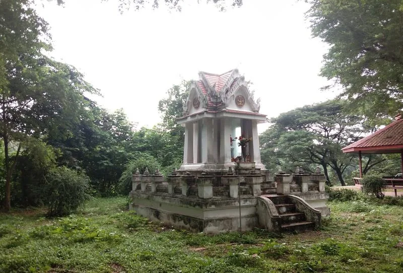
15. Phra Bowon Ratchawang Sitha is located in Song Khon Subdistrict, Kaeng Khoi District. It is an archaeological site associated with the royal history of King Pinklao. Today, visitors can still see plastered brick foundations, elements of the former palace layout, and architectural traces that help reconstruct the character of the royal residence.
Highlights: Palace foundations, plastered brick structures, entrance platforms, history associated with King Pinklao, Bueng Talat Chai, and the historical landscape of Song Khon.
The site is important because it reflects Saraburi’s role as a travel corridor and as a location for royal residences outside Bangkok. The choice of Sitha, close to natural landscapes and transportation routes, demonstrates how geography influenced the placement of royal residences.
Although many buildings no longer survive intact, foundations and structural lines still help visitors understand the original extent of the palace. Exploring such ruins is best done by examining the layout, brick foundations, and surrounding landscape rather than expecting complete standing buildings.
The area connected with Bueng Talat Chai further illustrates the environmental context of the former palace and shows how the residence was integrated with water sources and local geography.
The site is well suited to students, history enthusiasts, and travelers who appreciate archaeological remains rather than fully reconstructed monuments. Visitors should avoid climbing on foundations or moving bricks and other materials.
Phra Bowon Ratchawang Sitha can be combined with Khao Phra Phutthabat Noi and Tham Phra Phothisat Cave for a 1-day route through Song Khon and Thap Kwang focusing on royal history, religion, and limestone landscapes.
Open Days: Daily Opening Hours: 08:30 – 16:30
Getting There: The site is in Song Khon Subdistrict, Kaeng Khoi District. From Mittraphap Road, turn onto local roads in Song Khon and follow signs for the archaeological site.
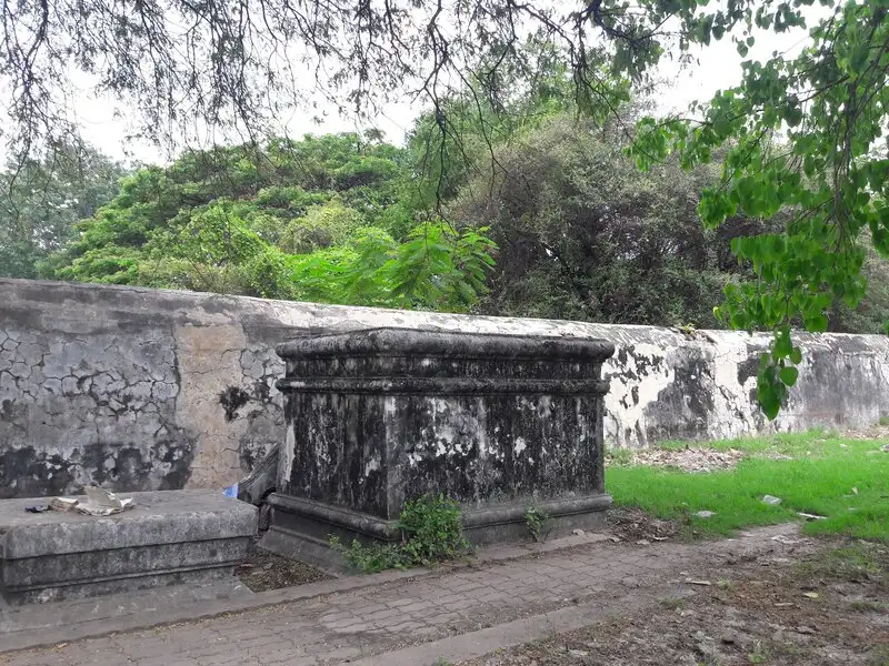
16. Phra Tamnak Thai Phikun (The Old Palace) is located in Khun Khlon Subdistrict, Phra Phutthabat District. The archaeological site is directly connected with royal pilgrimage routes to the Buddha Footprint during the Ayutthaya period. Although the residence itself no longer survives intact, elephant-mounting platforms, wall remains, building foundations, and evidence of an old water-supply system still help illustrate the character of the palace complex.
Highlights: Ancient royal-residence foundations, elephant mounting platform, wall remains, building foundations, water-supply system from Than Thong Daeng, history of royal pilgrimages to Phra Phutthabat, and close proximity to Wat Phra Phutthabat Ratchaworamahawihan.
Phra Tamnak Thai Phikun formed part of the support infrastructure for royal journeys to Phra Phutthabat during a period when travel from Ayutthaya required considerable time. Such royal residences were necessary for accommodation, ceremonial organization, and managing the large entourage accompanying the king.
The surviving remains allow visitors to understand the layout and scale of the former complex. Although no complete palace buildings remain, archaeology enthusiasts can study relationships between foundations, walls, and the surrounding landscape.
The water-supply system from Than Thong Daeng is another important feature because it shows how water resources were managed to support the royal residence and surrounding community. The site was therefore designed in relation to pilgrimage routes, religious monuments, and the natural geography of Phra Phutthabat.
Visitors to Wat Phra Phutthabat Ratchaworamahawihan can add Phra Tamnak Thai Phikun without traveling far. Doing so helps reveal that historic Phra Phutthabat was not just a temple but a larger cultural landscape of royal residences, roads, waterways, and supporting infrastructure.
The site is best suited to history enthusiasts, students, and visitors interested in Ayutthaya archaeology. Avoid climbing walls or foundations and do not move any archaeological materials.
Open Days: Daily Opening Hours: 08:30 – 16:30
Getting There: Phra Tamnak Thai Phikun is in Khun Khlon Subdistrict, Phra Phutthabat District, close to Wat Phra Phutthabat Ratchaworamahawihan. It can be included easily in a wider Phra Phutthabat heritage route.

17. Central Botanical Garden, also known as Phu Khae Botanical Garden, is located in Phu Khae Subdistrict, Chaloem Phra Kiat District. It is an historically important botanical garden in Thailand and contains extensive plant collections. The broad grounds include native trees, medicinal plants, literary plants, streams, and natural areas suitable for families, students, and botany enthusiasts.
Highlights: One of Thailand’s long-established botanical gardens, more than 4,000 rai of grounds, plants from many families, native species, medicinal plants, plants mentioned in Thai literature, streams, and nature-learning areas.
The garden was established in 1941 and has played an important role in collecting, studying, and conserving plants of Central Thailand. Its large area means that visitors can see plants in environments closer to natural ecosystems rather than only in formal garden beds.
Collections include native trees, medicinal plants, and species mentioned in Thai literature. A walk through the garden can therefore connect botany with culture, language, and traditional plant knowledge.
Streams and green spaces make the area suitable for relaxation and learning without strenuous trekking. It is especially appropriate for children and older travelers who want a nature experience without steep mountain or waterfall terrain.
Photographers can focus on plants, flowers, pathways, and broader natural landscapes. Morning is usually the most comfortable time for walking because temperatures are lower and light is softer.
The Central Botanical Garden can be combined with attractions around Phu Khae and Phra Phutthabat and works well on a slower day focused on nature, community food, and culture rather than deep forest travel.
Open Days: Daily Opening Hours: 08:00 – 16:30
Getting There: The garden is in Phu Khae Subdistrict, Chaloem Phra Kiat District. It is easily reached by road from central Saraburi or Phra Phutthabat District.

18. Tham Narai (Khao Wong Cave) is located within Wat Khao Wong in Khao Wong Subdistrict, Phra Phutthabat District. It is an important historical and archaeological site because of an ancient inscription that helps explain the development of language, religion, and culture in Central Thailand before the Sukhothai period. The cave lies beside a rock cliff and retains a calm atmosphere suitable for visitors interested in deeper historical study.
Highlights: Ancient inscription, Mon-Pallava script, natural cave, evidence linked with Dvaravati-period culture, Wat Khao Wong, and a meditation atmosphere inside the cave.
The cave is especially important because its inscription uses an ancient script belonging to a writing tradition widespread in Southeast Asia before the development of modern Thai script. This evidence helps historians and epigraphers understand relationships among early communities, religion, and culture in Central Thailand.
The inscription refers to individuals and activities associated with the celebration of a sacred object enshrined at the site, showing that the cave was more than a natural cavity and functioned as a sacred space important to an earlier community.
The cave has been adapted in places for worship and meditation while retaining much of its natural atmosphere. Visitors experience coolness, silence, and the sense of an ancient place used for religious purposes across multiple periods.
Tham Narai is especially suitable for students, visitors interested in ancient scripts and Dvaravati history, and travelers who enjoy archaeological sites still functioning within an active temple environment. Dress respectfully, maintain quiet, and avoid touching inscriptions or rock surfaces.
The cave can be combined with Wat Phra Phutthabat Ratchaworamahawihan, Phra Tamnak Thai Phikun, and Thep Nimit Than Thong Daeng Cave for a Phra Phutthabat route covering several historical periods from early communities to the Ayutthaya royal era.
Open Days: Daily Opening Hours: 09:00 – 11:00 / 13:00 – 16:00
Getting There: Tham Narai is within Wat Khao Wong, Khao Wong Subdistrict, Phra Phutthabat District. From Phra Phutthabat town, follow local roads to Wat Khao Wong and signs for the cave.
Map (GPS):Open Google Maps – Tham Narai

19. Thep Nimit Than Thong Daeng Cave is located within Wat Phu Kham Banphot in Phu Kham Chan Subdistrict, Phra Phutthabat District. It is a prehistoric archaeological site that offers insight into early human settlement in the upper Central Region. Although archaeological objects are no longer displayed inside the cave, the location remains valuable because of its excavation history and surrounding landscape.
Highlights: Prehistoric archaeological site, natural cave, Late Neolithic artifacts formerly found in the area, cultural connections with ancient communities in Lopburi, and the atmosphere of Wat Phu Kham Banphot.
Archaeological studies found that evidence from the site shared characteristics with material from Lopburi-area sites such as Ban Tha Khae, Ban Di Lang, and Sap Champa. These similarities suggest that ancient communities were not isolated but interacted or shared cultural patterns across the upper Central Region.
Evidence once found here has been associated with the Late Neolithic period, showing that Saraburi’s human history extends far beyond the Ayutthaya and Rattanakosin eras.
The cave and surrounding temple area are quiet and surrounded by limestone hills and rural scenery. Visitors should therefore approach it primarily as a historical learning site rather than expecting a spectacular show cave.
The attraction suits archaeology enthusiasts, students, and visitors interested in prehistoric history who want to see the type of real landscape associated with ancient settlement. Do not remove stones or any materials from the site.
The cave can be combined with Tham Narai, Wat Phra Phutthabat Ratchaworamahawihan, and other archaeological sites in Phra Phutthabat District to compare the area’s development from prehistory into later historical periods.
Open Days: Daily Opening Hours: 08:30 – 16:30
Getting There: The cave is within Wat Phu Kham Banphot, Phu Kham Chan Subdistrict, Phra Phutthabat District. From the district center, follow local roads toward Phu Kham Chan and signs for the temple.

20. Sub Wae Waterfall is located in Sap Sanun Subdistrict, Muak Lek District. It is a relatively secluded waterfall hidden in a forested valley and feels more natural than better-developed waterfall attractions. Water falls from a cliff approximately 30 meters high into a pool below, while visitors reach the site via a walking trail of about 800 meters.
Highlights: Waterfall approximately 30 meters high, earthen cliff, cavity in the cliff face, natural pool, 800-meter walking trail, green forest, and a small cave near the waterfall.
Although the walk is less than 1 kilometer, the route remains fairly natural and can be difficult in places. Suitable footwear is important, especially after rain when the ground may become slippery.
The waterfall is distinguished by its high cliff and a deep cavity in the central section, creating a layered scene of falling water, rock, and valley topography that differs from more typical cascades.
A large natural pool lies below the waterfall. When water conditions are safe, visitors may be able to swim in suitable areas, but changing water levels after rain and deeper sections require caution.
A path beside the waterfall also leads toward a small cave with stalactites and stalagmites, adding geological interest and allowing visitors to experience more than the waterfall alone.
Sub Wae Waterfall is suitable for groups of friends, nature enthusiasts, and visitors seeking a quieter Muak Lek destination. It combines well with Tham Dao Khao Kaeo Cave and Namtok Chet Sao Noi National Park for travelers with a private car and a full day available.
Open Days: Daily Opening Hours: 07:00 – 18:00
Getting There: The waterfall is in Sap Sanun Subdistrict, Muak Lek District. Drive along local roads to the trailhead, then continue on foot for approximately 800 meters. Daylight travel is recommended, and heavy-rain periods should be avoided.
Map (GPS):Open Google Maps – Sub Wae Waterfall

21. Phra Tamnak Sa Yo is located in Khun Khlon Subdistrict, Phra Phutthabat District. It is an archaeological site directly connected with royal pilgrimage routes to the Buddha Footprint during the Ayutthaya period. Its value lies not in surviving palace buildings, because only foundations remain, but in the evidence that historic Phra Phutthabat included royal residences, pilgrimage routes, water sources, and extensive supporting infrastructure.
Highlights: Ayutthaya-period royal-residence foundations, King Prasat Thong, Than Thong Daeng stream, ancient pond, royal pilgrimage route to Phra Phutthabat, and the archaeological landscape of Khun Khlon.
Phra Tamnak Sa Yo was built during the reign of King Prasat Thong for use during royal pilgrimages to the Buddha Footprint. The presence of such residences demonstrates the organized nature of royal pilgrimage, requiring accommodation, transport routes, water supply, and ceremonial areas.
The remaining foundations were built with stone and mortar and still allow archaeology enthusiasts to identify the former building position. Although no tall structures survive, the site is useful for landscape-based interpretation and understanding architecture from its remaining traces.
The residence was positioned in relation to Than Thong Daeng, an important watercourse in the Phra Phutthabat area. Water was essential for choosing the site and supporting large royal entourages, helping explain why many archaeological remains here are distributed close to streams and other water sources.
An old pond northeast of the residence is associated with the name “Sa Yo.” Visiting this site together with Phra Tamnak Thai Phikun and Wat Phra Phutthabat Ratchaworamahawihan provides a more complete understanding of Phra Phutthabat’s historical sacred landscape.
The site is suitable for students, historians, and visitors who enjoy archaeological remains preserved in place. Avoid climbing on foundations or moving stones and materials.
Open Days: Daily Opening Hours: 08:00 – 17:00
Getting There: Phra Tamnak Sa Yo is in Khun Khlon Subdistrict, Phra Phutthabat District, close to the Phra Phutthabat archaeological zone and Wat Phra Phutthabat Ratchaworamahawihan.
Map (GPS):Open Google Maps – Phra Tamnak Sa Yo

22. Tham Sriwilai Cave is located within Wat Tham Sriwilai in Na Phra Lan Subdistrict, Chaloem Phra Kiat District. It combines the natural character of a limestone cave with a Buddhist atmosphere. Inside are stalactites, stalagmites, and an important Buddha image, while the exterior offers broad views of Saraburi’s mountain landscape.
Highlights: Limestone cave, stalactites and stalagmites, Phra Phuttha Nawarat, Chiang Saen-style Buddhist art, mountain-temple atmosphere, and views across Na Phra Lan.
Inside the cave is Phra Phuttha Nawarat, a Buddha image showing characteristics associated with Chiang Saen art. The cave therefore functions not only as a geological attraction but also as a place of worship and Buddhist activity.
Stalactites and stalagmites have formed over long periods of natural geological processes. Different parts of the walls and ceiling display varied shapes and textures that become more visible as light reaches them.
The cave’s cool, quiet interior contrasts strongly with the outside environment and suits travelers seeking a peaceful visit. Walk carefully on damp surfaces and avoid touching cave formations.
Outside the cave, visitors can see the mountain landscape around Na Phra Lan. Morning and late afternoon are especially suitable for photography because the light is softer and temperatures are more comfortable.
Tham Sriwilai can be combined with the Central Botanical Garden, Wat Phra Phutthabat Ratchaworamahawihan, and other attractions around Na Phra Lan and Phu Khae for a trip combining nature, religion, and botany.
Open Days: Daily Opening Hours: 08:00 – 16:30
Getting There: The cave is within Wat Tham Sriwilai, Na Phra Lan Subdistrict, Chaloem Phra Kiat District. From central Saraburi, drive toward Na Phra Lan and follow signs to the temple.
Map (GPS):Open Google Maps – Tham Sriwilai Cave

23. Bo Phrahan Lang Nuea is an important legendary and religious site in Phra Phutthabat District because it is connected with the story of Hunter Bun and the discovery of the sacred Buddha Footprint. The site consists of a natural rock pool and features associated with a local legend that has been passed down for generations.
Highlights: Legend of Hunter Bun, natural rock pool, marks believed to be knee impressions, spear-hole legend, water flowing from the rock, and close connection with the Phra Phutthabat Buddha Footprint.
According to local tradition, Hunter Bun hunted animals and washed meat at this pool before later events led to the discovery of the Buddha Footprint. The site therefore forms part of the larger sacred landscape around Phra Phutthabat rather than standing entirely apart from the temple.
Marks near the pool are locally associated with the hunter’s knees, while nearby holes in rock are linked with stories about planting a spear. Such beliefs show how natural geography has been incorporated into local sacred storytelling.
Another point of interest is water that continuously emerges from the rock and is regarded as auspicious in local belief. Visitors should treat the area respectfully and avoid activities that could damage the pool or rock surface.
Although the site is small, it is valuable for travelers who want to connect the legend of the Buddha Footprint with an actual landscape. Visiting Bo Phrahan Lang Nuea together with Wat Phra Phutthabat provides much stronger historical and cultural context.
The site suits Buddhist travelers, students, and visitors interested in folklore. It can be combined easily with Phra Tamnak Sa Yo, Phra Tamnak Thai Phikun, or Tham Krabok Monastery.
Open Days: Daily
Getting There: Use the same general route as Wat Phra Phutthabat Ratchaworamahawihan. From central Saraburi, take Phahonyothin Road toward Phra Phutthabat District, then continue to the Bo Phrahan Lang Nuea area.
Map (GPS):Open Google Maps – Bo Phrahan Lang Nuea

24. Tham Krabok Monastery is located around the Prong Prap mountain range in Khun Khlon Subdistrict, Phra Phutthabat District. It is known in Thailand and internationally for its role in addiction rehabilitation and recovery, giving it importance not only as a Buddhist religious site but also as a center of social welfare and second chances.
Highlights: History of Mae Chi Mian Panjan, Luang Pho Chamrun Panjan, addiction rehabilitation work, Prong Prap mountain setting, meditation areas, and internationally recognized social work.
The monastery’s origins are connected with Mae Chi Mian Panjan, who founded it in 1957, followed by Luang Pho Chamrun Panjan, who continued its work. Helping people affected by addiction became a defining mission and made Tham Krabok widely known beyond the local community.
Luang Pho Chamrun received international recognition for his work helping people with drug addiction and was awarded the Ramon Magsaysay Award in 1975. This reflects the wider social impact of the monastery’s work.
The monastery lies at the foot of the mountains and includes areas for Buddhist activities, meditation, and rehabilitation. Visitors should understand that it remains a working center rather than a conventional sightseeing attraction.
Visitors should follow the monastery’s rules carefully, avoid disturbing people receiving rehabilitation, and never photograph individuals without permission because some areas involve privacy and treatment.
Tham Krabok can be combined with Wat Phra Phutthabat Ratchaworamahawihan, Bo Phrahan Lang Nuea, and archaeological sites around Khun Khlon, creating a route that shows both the historical and contemporary social roles of Buddhism.
Open Days: Daily Opening Hours: 08:30 – 16:30
Getting There: The monastery is in Khun Khlon Subdistrict, Phra Phutthabat District, near the Phahonyothin Road corridor. It is easily reached by private car.
Map (GPS):Open Google Maps – Tham Krabok Monastery

25. Yana Farm (Rai Yana) is located in Wang Muang Subdistrict, Wang Muang District. It is an agritourism destination with the atmosphere of a working farm and is particularly suitable for families. The site includes animals such as goats, sheep, deer, and ostriches, together with agricultural areas and farm products.
Highlights: Farm animals, goats, sheep, deer, ostriches, farm products, rural Wang Muang scenery, and child-friendly agricultural activities.
The charm of Yana Farm lies in its working agricultural character. Visitors can see animals, farm areas, and agricultural products within the same environment rather than visiting a space created only for photography.
Children can learn about animals and farming through direct experience, making the farm suitable for families seeking light activities without forest hiking or mountain climbing. Adults can also relax in open rural surroundings.
Goat products and other farm produce add another layer of interest by showing the relationship between animal husbandry, production, and products sold to consumers.
Wang Muang District has an agricultural and rural character and is popular for scenic drives in the cool season, particularly when sunflower fields appear in surrounding areas. Including Yana Farm adds farm life and agricultural scenery to the route.
Yana Farm is suitable for a half-day visit and can serve as a stop between Wang Muang and Muak Lek or on routes toward the Pa Sak Jolasid Dam area.
Open Days: Daily Opening Hours: 08:00 – 18:00
Getting There: Yana Farm is in Wang Muang Subdistrict, Wang Muang District. A private vehicle is the most convenient option for continuing to other attractions around Wang Muang and Muak Lek.
Map (GPS):Open Google Maps – Yana Farm

26. Khao Khrok lies within Namtok Sam Lan National Park in Nong Pla Lai Subdistrict, Mueang Saraburi District. The summit rises approximately 329 meters above sea level and offers one of the park’s interesting landscape viewpoints, with broad views over forest, Saraburi city, and surrounding plains.
Highlights: Summit approximately 329 meters above sea level, panoramic viewpoint, Namtok Sam Lan National Park forest, views toward Saraburi city, and route connections with Wat Phra Phutthachai.
Khao Khrok reveals another side of Namtok Sam Lan National Park because many visitors know the park mainly for its waterfalls. The broader landscape also contains ridges, forests, and elevated viewpoints that provide a clearer understanding of the surrounding terrain.
From higher points, visitors can observe relationships among forest, settlements, roads, and agricultural land, giving the viewpoint both scenic and geographical value.
Morning and late afternoon are best for scenery and photography because temperatures are cooler and the light creates more depth across the hills and plains.
Hikers should wear appropriate shoes, carry water, and check trail conditions with park staff. After rain, surfaces may become slippery, and visitors should avoid leaving trails or remaining on high ground close to darkness.
Khao Khrok can be combined with Sam Lan Waterfall, Wat Phra Phutthachai, and the Phra Phutthachai Railway Tunnel for a 1-day route featuring viewpoints, waterfalls, religion, and railway history.
Open Days: Daily Opening Hours: 08:00 – 17:00
Getting There: Khao Khrok is within Namtok Sam Lan National Park in Nong Pla Lai Subdistrict, Mueang Saraburi District. Begin from the national park area and ask staff for the current route before heading to the viewpoint.
Map (GPS):Open Google Maps – Khao Khrok

27. Khit Khin Ancient City (Senarat Nakhon / Prantapa City) is an ancient settlement in Ban Mo District that reveals another layer of Saraburi history before the development of the modern province. Earthen embankments still surround parts of the old city, while a central mound known as “Khok Prasat” remains an important feature for understanding the settlement plan.
Highlights: Ancient city, earthen defensive embankments, Khok Prasat mound, archaeology of the Pa Sak River basin, a Naga-protected Buddha image once discovered nearby, and legends associated with Senarat Nakhon.
Although no major buildings survive intact, the embankments and central mound help visitors visualize the organization of the ancient settlement. The site is therefore best appreciated by studying the landscape and position of the remaining features rather than expecting restored monuments.
A Naga-protected Buddha image was once discovered near the old landing area, providing evidence of religious activity and the historical importance of the community. This gives Khit Khin value both as an archaeological site and as a place for studying relationships between settlement and waterways.
Local traditions also connect Senarat Nakhon with the Ramakien story of Sugriva and Khit Khin. Although these accounts belong to the sphere of legend and literature rather than direct archaeology, they show how local communities have interpreted and given meaning to the ancient city.
The site suits archaeology enthusiasts, history lovers, and travelers interested in ancient urban settlements. Visitors should never dig, search for, or remove objects because even small finds can lose their archaeological meaning when separated from their original context.
Khit Khin adds useful variety to a Saraburi itinerary by showing that the province’s past includes not only temples, waterfalls, and mountains but also ancient urban communities along the Pa Sak basin.
Open Days: Daily Opening Hours: Accessible throughout the day
Getting There: The ancient city lies in Ban Mo District, Saraburi. A private vehicle is the most convenient option for reaching the community and surrounding archaeological landscape.

28. Thai Yuan Cultural Center, also known as the Saraburi Thai Yuan Folk Culture Hall, is an important learning center for Thai Yuan ethnicity and settlement history in Saraburi. Located around Ban Khao Kaeo near the Pa Sak River basin, it uses traditional wooden houses to display objects, tools, and textiles illustrating Thai Yuan life.
Highlights: Thai Yuan culture, traditional wooden houses, historic textiles, muk yok dok weaving, khit patterns, chok textiles, traditional tools, household vessels, and the migration history of Thai Yuan communities into Saraburi.
Thai Yuan communities in Saraburi have cultural roots linked with peoples from Lanna and Yonok regions. Population movements during the early Rattanakosin period brought some Thai Yuan groups into the Pa Sak River basin, where they established communities and preserved many traditions.
The center contains vessels, weapons, agricultural tools, occupational equipment, and everyday household objects. These materials allow visitors to understand culture through real artifacts ranging from farming and domestic life to local craftsmanship.
Textiles are among the most important collections, including muk yok dok, khit-pattern cloth, and chok textiles. Their detailed designs reflect identity, belief, aesthetics, and skills passed from one generation to the next.
The atmosphere of traditional houses and shaded grounds creates a more immersive learning environment than a conventional display gallery. Visitors can see connections among architecture, household objects, and river-basin life within the same setting.
The Thai Yuan Cultural Center is especially suitable for students and visitors interested in ethnicity, textiles, and local history. It combines well with Wat Khao Kaeo Worawihan, Wat Samuha Pradittharam, and Sao Hai communities for a cultural route very different from Saraburi’s natural attractions.
Open Days: Daily Opening Hours: 08:30 – 16:00
Getting There: The center is in the Ban Khao Kaeo area near the Pa Sak River basin. From central Saraburi, drive toward the Dao Rueang–Sao Hai zone.
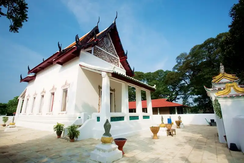
29. Wat Khao Kaeo Worawihan is located in Ton Tan Subdistrict, Sao Hai District. It is a third-class royal monastery of the Worawihan type and an old temple significant for history, art, architecture, and landscape. The temple stands on a small hill near the Pa Sak River, with a distinctive white chedi forming its most recognizable landmark.
Highlights: Royal-monastery status, 34-meter-high twelve-indented-corner chedi, Buddha relics, relics of disciples, naga stairway, ordination hall, and major restoration during the reign of King Rama IV.
The temple’s history extends back to the Ayutthaya period and is traditionally dated to around 1628 during the reign of King Songtham. Major restoration later took place during the reign of King Mongkut, Rama IV, when the temple was elevated to royal-monastery status.
King Mongkut regarded the site as peaceful and suitable for monastic practice and assigned Chao Phraya Nikon Bodin to oversee restoration. Work included improvements to the ordination hall, walls, monks’ quarters, and chedi.
The chedi is the most prominent feature. Its twelve-indented-corner form rises approximately 34 meters and is associated with the enshrinement of Buddha relics and relics of disciples. Numerous decorative elements around the structure make it particularly interesting to visitors studying Thai architecture.
The stairway is decorated with nagas and architectural details reflecting blended Rattanakosin influences. The temple’s slightly elevated setting also provides a more open atmosphere and views over the surrounding community.
Wat Khao Kaeo Worawihan lies close to the Thai Yuan Cultural Center and other Sao Hai attractions, making it well suited to a 1-day route focused on royal monasteries, art, and Pa Sak River community culture.
Open Days: Daily Opening Hours: 08:30 – 16:30
Getting There: The temple is in Ton Tan Subdistrict, Sao Hai District. From central Saraburi, drive toward Sao Hai and follow local signs to Wat Khao Kaeo Worawihan.
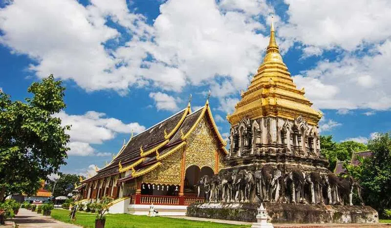
30. Wat Samuha Pradittharam is located in Suan Dokmai Subdistrict, Sao Hai District. It is a third-class royal monastery and is particularly notable for Rama III-period art, administrative history, and education in Saraburi. Its old ordination hall preserves a distinctive blend of traditional Thai craftsmanship and Chinese artistic influence.
Highlights: Rama III-period ordination hall, stucco pediment with state emblems, Chinese decorative motifs, murals, Phra Phuttha Ratcha Kalyanamitra Pradittharam, and the history of Saraburi’s first public primary school.
The temple was established by Chao Phraya Nikon Bodin, also known as To Kalyanamitra, in dedication to his mother before being offered to the king as a royal monastery. This origin links the temple with the Kalyanamitra family and major officials of the Rattanakosin period.
It is believed that the temple may once have been used for the oath-of-allegiance ceremony known as the Drinking of the Water of Allegiance for provincial officials, demonstrating that its role extended beyond religion into administration and state ritual.
In education, the temple once housed Saraburi’s first public primary school, which opened in 1908, and later also supported Buddhist scripture education. It therefore functioned as a long-standing learning center for both monks and local communities.
The ordination hall is the architectural highlight. Its pediment features stucco representing state emblems from the reign of Rama III, decorated with floral and lion motifs, while door frames and guardian figures show Chinese artistic influence typical of the period.
Inside is Phra Phuttha Ratcha Kalyanamitra Pradittharam, a Buddha image in the Subduing Mara posture brought from Sukhothai, together with murals that further increase the artistic value of the interior.
Wat Samuha Pradittharam combines easily with Wat Khao Kaeo Worawihan, the Thai Yuan Cultural Center, and the old Sao Hai community, creating a cultural route that balances Saraburi’s better-known forests and mountains with the history of Pa Sak River communities.
Open Days: Daily Opening Hours: 06:00 – 18:00
Getting There: The temple is in Suan Dokmai Subdistrict, Sao Hai District. From central Saraburi, take the road toward Sao Hai and follow signs to Wat Samuha Pradittharam. It is easy to continue from here to Wat Khao Kaeo Worawihan and Thai Yuan cultural attractions.
| Category | Details |
| Phra Phutthabat Zone | 1. Wat Phra Phutthabat Ratchaworamahawihan 2. Phra Tamnak Thai Phikun 3. Tham Narai (Khao Wong Cave) 4. Thep Nimit Than Thong Daeng Cave 5. Phra Tamnak Sa Yo 6. Bo Phrahan Lang Nuea 7. Tham Krabok Monastery Best for Buddhist pilgrimage, history, archaeology, and understanding the old royal pilgrimage route to the Buddha Footprint in greater depth. |
| Central Saraburi–Phra Phutthachai–Sam Lan Zone | 1. Namtok Sam Lan National Park 2. Wat Phra Phutthachai 3. Phra Phutthachai Railway Tunnel 4. Khao Khrok Ideal for combining easy-access nature, history, religion, viewpoints, and railway scenery in a single day. |
| Kaeng Khoi–Thap Kwang–Cha-om Zone | 1. Tham Phra Phothisat Cave 2. Wat Pa Sawang Bun 3. Chet Khot–Pong Kon Sao Nature Study and Ecotourism Center 4. Pha Sadet 5. Krok E Dok Waterfall 6. Khao Phra Phutthabat Noi 7. Phra Bowon Ratchawang Sitha Best for hiking, photography, railway history, caves, forest monasteries, and limestone landscapes. |
| Muak Lek Zone | 1. Namtok Chet Sao Noi National Park 2. Thai-Danish Dairy Farm 3. Muak Lek Arboretum 4. Tham Dao Khao Kaeo Cave 5. Sub Wae Waterfall Best for families, children, nature lovers, agritourism, waterfalls, caves, and outdoor activities. |
| Wang Muang Zone | 1. Yana Farm Suitable for families, children, and road-trip travelers who want a working-farm atmosphere, animals, and rural Saraburi scenery. |
| Sao Hai–Pa Sak River Zone | 1. Thai Yuan Cultural Center 2. Wat Khao Kaeo Worawihan 3. Wat Samuha Pradittharam Best for Thai Yuan heritage, traditional textiles, Rattanakosin art, royal monasteries, and Pa Sak River community history. |
| Ban Mo Zone | 1. Khit Khin Ancient City Suitable for archaeology enthusiasts interested in ancient settlement plans, earthen city embankments, and early communities in the Pa Sak River basin. |
| Na Phra Lan–Phu Khae Zone | 1. Central Botanical Garden 2. Tham Sriwilai Cave Suitable for families, older visitors, students, and travelers interested in plants, limestone caves, and accessible nature. |
| Best for First-Time Visitors | 1. Wat Phra Phutthabat Ratchaworamahawihan 2. Namtok Chet Sao Noi National Park 3. Wat Phra Phutthachai 4. Thai-Danish Dairy Farm 5. Wat Pa Sawang Bun 6. Namtok Sam Lan National Park 7. Muak Lek Arboretum Together these provide a broad introduction to Saraburi through religion, history, nature, agriculture, and landscape. |
| Best for Families and Children | 1. Thai-Danish Dairy Farm 2. Namtok Chet Sao Noi National Park 3. Muak Lek Arboretum 4. Yana Farm 5. Central Botanical Garden 6. Thai Yuan Cultural Center Suitable for learning about animals, agriculture, nature, plants, and local culture through real environments. |
| Best for History Lovers | 1. Wat Phra Phutthabat Ratchaworamahawihan 2. Phra Tamnak Thai Phikun 3. Phra Tamnak Sa Yo 4. Pha Sadet 5. Phra Bowon Ratchawang Sitha 6. Tham Narai 7. Khit Khin Ancient City 8. Wat Khao Kaeo Worawihan 9. Wat Samuha Pradittharam 10. Wat Phra Phutthachai |
| Best for Buddhist and Spiritual Travel | 1. Wat Phra Phutthabat Ratchaworamahawihan 2. Wat Phra Phutthachai 3. Wat Pa Sawang Bun 4. Tham Krabok Monastery 5. Wat Khao Kaeo Worawihan 6. Wat Samuha Pradittharam 7. Tham Phra Phothisat Cave 8. Tham Sriwilai Cave 9. Tham Narai 10. Bo Phrahan Lang Nuea |
| Best for Nature Lovers | 1. Namtok Chet Sao Noi National Park 2. Namtok Sam Lan National Park 3. Chet Khot–Pong Kon Sao Nature Study and Ecotourism Center 4. Krok E Dok Waterfall 5. Sub Wae Waterfall 6. Muak Lek Arboretum 7. Khao Khrok 8. Khao Phra Phutthabat Noi 9. Tham Dao Khao Kaeo Cave 10. Central Botanical Garden |
| Best for Hiking | 1. Krok E Dok Waterfall 2. Chet Khot–Pong Kon Sao Nature Study and Ecotourism Center 3. Khao Khrok 4. Sub Wae Waterfall 5. Namtok Sam Lan National Park Krok E Dok is the most demanding option, while Sam Lan and Khao Khrok are more suitable for beginners. |
| Best for Cave Exploration | 1. Tham Phra Phothisat Cave 2. Tham Dao Khao Kaeo Cave 3. Tham Narai (Khao Wong Cave) 4. Thep Nimit Than Thong Daeng Cave 5. Tham Sriwilai Cave Each has a different appeal, including cave formations, religion, archaeology, inscriptions, and prehistoric evidence. |
| Best for Art and Architecture | 1. Wat Phra Phutthabat Ratchaworamahawihan 2. Wat Pa Sawang Bun 3. Wat Khao Kaeo Worawihan 4. Wat Samuha Pradittharam 5. Wat Phra Phutthachai 6. Tham Phra Phothisat Cave Suitable for studying stupas, ordination halls, murals, sculpture, and religious art from several periods. |
| Best for Archaeology | 1. Tham Narai 2. Thep Nimit Than Thong Daeng Cave 3. Khit Khin Ancient City 4. Wat Phra Phutthachai 5. Phra Tamnak Thai Phikun 6. Phra Tamnak Sa Yo 7. Phra Bowon Ratchawang Sitha |
| Best for Local Culture | 1. Thai Yuan Cultural Center 2. Wat Samuha Pradittharam 3. Wat Khao Kaeo Worawihan 4. Khit Khin Ancient City 5. Thai-Danish Dairy Farm Together they reveal Thai Yuan culture, Pa Sak River communities, ancient-city history, and the development of modern agriculture in Saraburi. |
| Best for Photography | 1. Wat Pa Sawang Bun 2. Krok E Dok Waterfall 3. Pha Sadet 4. Phra Phutthachai Railway Tunnel 5. Khao Khrok 6. Muak Lek Arboretum 7. Wat Khao Kaeo Worawihan 8. Wat Phra Phutthabat Ratchaworamahawihan 9. Namtok Chet Sao Noi National Park 10. Thai Yuan Cultural Center |
| Best for Farms and Agriculture | 1. Thai-Danish Dairy Farm 2. Yana Farm Suitable for learning about livestock, farm products, and the role of agriculture in Saraburi’s economy and identity. |
| Food and Local Products to Try | 1. Dairy products from Muak Lek 2. Fresh milk and dairy-farm products 3. Goat products from Wang Muang 4. Local food in Sao Hai communities 5. Seasonal agricultural products 6. Thai Yuan and Pa Sak River community products |
| Recommended Souvenirs | 1. Dairy products 2. Farm products 3. Thai Yuan textiles and handicrafts 4. Seasonal agricultural products 5. Herbal and community products 6. Souvenirs from Muak Lek and Sao Hai |
| Distinctive Saraburi Identity | The Buddha Footprint and pilgrimage tradition, Dong Phayayen forests, waterfalls and limestone caves, the Thai-Danish Dairy Farm, historic railway routes, Thai Yuan culture, Pa Sak River communities, and archaeological sites connected with the old Phra Phutthabat pilgrimage route. |
| Recommended Areas to Stay | 1. Muak Lek: Best for Chet Sao Noi, the Thai-Danish Dairy Farm, Muak Lek Arboretum, and Tham Dao Khao Kaeo 2. Kaeng Khoi: Best for Chet Khot–Pong Kon Sao, Krok E Dok, Wat Pa Sawang Bun, Tham Phra Phothisat, and Pha Sadet 3. Mueang Saraburi: Best for Sam Lan, Phra Phutthachai, Khao Khrok, and as a central base for several districts 4. Phra Phutthabat: Best for the Buddha Footprint temple, archaeological sites, caves, and religious attractions For a 2-night trip, consider the first night in Muak Lek or Kaeng Khoi and the second night in central Saraburi or Phra Phutthabat. |
| 1-Day Saraburi Itinerary – Phra Phutthabat and History | Morning: Wat Phra Phutthabat Ratchaworamahawihan Late Morning: Phra Tamnak Thai Phikun – Phra Tamnak Sa Yo Lunch: Phra Phutthabat District Afternoon: Tham Narai – Bo Phrahan Lang Nuea Evening: Tham Krabok Monastery if time permits |
| 1-Day Saraburi Itinerary – Central Saraburi and Sam Lan | Morning: Wat Phra Phutthachai Late Morning: Namtok Sam Lan National Park Lunch: Central Saraburi or near the park Afternoon: Khao Khrok Evening: Phra Phutthachai Railway Tunnel |
| 1-Day Saraburi Itinerary – Family Trip in Muak Lek | Morning: Thai-Danish Dairy Farm Lunch: Muak Lek Afternoon: Muak Lek Arboretum Late Afternoon: Namtok Chet Sao Noi National Park |
| 1-Day Saraburi Itinerary – Kaeng Khoi and Cha-om | Morning: Wat Pa Sawang Bun Late Morning: Chet Khot–Pong Kon Sao Nature Study and Ecotourism Center Lunch: Cha-om–Kaeng Khoi area Afternoon: Tham Phra Phothisat Cave Evening: Pha Sadet |
| 1-Day Saraburi Itinerary – Sao Hai and Thai Yuan Culture | Morning: Thai Yuan Cultural Center Late Morning: Wat Khao Kaeo Worawihan Lunch: Sao Hai District Afternoon: Wat Samuha Pradittharam Evening: Walk around the community and Pa Sak River landscape |
| 1-Day Saraburi Itinerary – Serious Nature Trip | Krok E Dok Waterfall should be treated as the main activity of the day because the hike takes substantial time and access follows official schedules. Begin early and avoid overloading the day with other attractions. Wat Pa Sawang Bun or nearby Chet Khot attractions can be added afterward only if time and physical condition allow. |
| 2 Days 1 Night – Muak Lek and Kaeng Khoi | Day 1: Thai-Danish Dairy Farm – Muak Lek Arboretum – Namtok Chet Sao Noi National Park – stay in Muak Lek Day 2: Wat Pa Sawang Bun – Chet Khot–Pong Kon Sao – Tham Phra Phothisat Cave – Pha Sadet |
| 2 Days 1 Night – History and Culture | Day 1: Wat Phra Phutthabat Ratchaworamahawihan – Phra Tamnak Thai Phikun – Phra Tamnak Sa Yo – Tham Narai – stay in Phra Phutthabat Day 2: Thai Yuan Cultural Center – Wat Khao Kaeo Worawihan – Wat Samuha Pradittharam – Khit Khin Ancient City |
| 3 Days 2 Nights in Saraburi | Day 1: Thai-Danish Dairy Farm – Muak Lek Arboretum – Namtok Chet Sao Noi National Park – stay in Muak Lek Day 2: Wat Pa Sawang Bun – Chet Khot–Pong Kon Sao – Tham Phra Phothisat Cave – Pha Sadet – stay in Kaeng Khoi or central Saraburi Day 3: Wat Phra Phutthabat Ratchaworamahawihan – Phra Tamnak Thai Phikun – Phra Tamnak Sa Yo – Thai Yuan Cultural Center – Wat Khao Kaeo Worawihan |
| 4–5 Days in Saraburi | Day 1: Muak Lek – Thai-Danish Dairy Farm – Muak Lek Arboretum – Chet Sao Noi Day 2: Chet Khot–Pong Kon Sao – Krok E Dok Waterfall or Wat Pa Sawang Bun Day 3: Phra Phutthachai – Sam Lan – Khao Khrok – Phra Phutthachai Railway Tunnel Day 4: Phra Phutthabat – Phra Tamnak Thai Phikun – Phra Tamnak Sa Yo – Tham Narai – Tham Krabok Day 5: Sao Hai – Thai Yuan Cultural Center – Wat Khao Kaeo Worawihan – Wat Samuha Pradittharam – Khit Khin Ancient City or Yana Farm in Wang Muang |
| Best Way to Get Around | A private car is the most convenient option because the 30 attractions are spread across several districts. Phahonyothin Road is useful for central Saraburi, Phra Phutthabat, Sao Hai, and Ban Mo, while Mittraphap Road is best for Muak Lek, Kaeng Khoi, and Thap Kwang. Planning by zone is the best way to reduce backtracking. |
| Best Time to Visit | Saraburi can be visited throughout the year. The rainy season is best for waterfalls and forests when water levels are stronger and vegetation is lush, but hiking safety notices should always be checked. November to February is ideal for outdoor sightseeing, temples, viewpoints, farms, and cultural attractions because temperatures are generally more comfortable. |
Frequently Asked Questions (FAQ)
Q: Where should first-time visitors go in Saraburi?
A: Recommended first stops include Wat Phra Phutthabat Ratchaworamahawihan, Namtok Chet Sao Noi National Park, Wat Phra Phutthachai, the Thai-Danish Dairy Farm, Wat Pa Sawang Bun, and Namtok Sam Lan National Park because together they provide a broad introduction to Saraburi’s religion, history, nature, and agriculture.
Q: Can Saraburi be visited in one day?
A: Yes, but it is best to choose only one zone such as Phra Phutthabat, Muak Lek, Sam Lan–Phra Phutthachai, or Sao Hai instead of spending the day driving back and forth across the province.
Q: Which Saraburi attractions near Bangkok are suitable for families?
A: The Thai-Danish Dairy Farm, Namtok Chet Sao Noi National Park, Muak Lek Arboretum, Central Botanical Garden, and Yana Farm are especially suitable because they are relatively easy to access and offer activities for children.
Q: Which Saraburi waterfall is best for families?
A: Namtok Chet Sao Noi is one of the most suitable major waterfalls for families because its several tiers are relatively easy to access. Swimming should still be limited to areas permitted by officials, and children should be closely supervised around the water.
Q: Is Krok E Dok Waterfall suitable for beginner hikers?
A: It is not recommended for travelers with no hiking experience or physical limitations because the route is long and includes slippery ground, streams, and steep sections. Proper preparation and compliance with the official registration system are essential.
Q: Which historical attractions should I visit in Saraburi?
A: Wat Phra Phutthabat Ratchaworamahawihan, Phra Tamnak Thai Phikun, Phra Tamnak Sa Yo, Pha Sadet, Phra Bowon Ratchawang Sitha, Tham Narai, Khit Khin Ancient City, Wat Khao Kaeo Worawihan, and Wat Samuha Pradittharam are among the strongest choices.
Q: Where should archaeology enthusiasts go in Saraburi?
A: Tham Narai is important for its ancient inscription, Thep Nimit Than Thong Daeng Cave is connected with prehistoric evidence, Khit Khin is an ancient-city site, and Wat Phra Phutthachai preserves prehistoric rock drawings and archaeological evidence from several periods.
Q: Which temple in Saraburi should I prioritize?
A: If choosing only one, Wat Phra Phutthabat Ratchaworamahawihan has the greatest historical and religious significance. Wat Pa Sawang Bun is especially notable for the 500-Spired Chedi, while Wat Khao Kaeo Worawihan is outstanding for its royal-monastery history and architecture.
Q: What is special about Wat Phra Phutthachai?
A: The site combines the sacred Phra Phutthachai image on a rock face, a Buddha Footprint, prehistoric rock drawings, and the natural environment of Khao Pathawi, making it significant for religion, archaeology, and nature at the same time.
Q: What should I visit in Muak Lek in one day?
A: An easy family itinerary begins at the Thai-Danish Dairy Farm in the morning, continues to Muak Lek Arboretum in the afternoon, and finishes at Namtok Chet Sao Noi National Park.
Q: Where should hikers go in Saraburi?
A: Chet Khot–Pong Kon Sao and Krok E Dok Waterfall are the principal choices. Chet Khot has trails of several difficulty levels, while Krok E Dok is better for experienced and physically prepared hikers.
Q: Which caves can I visit in Saraburi?
A: Tham Phra Phothisat, Tham Dao Khao Kaeo, Tham Narai, Thep Nimit Than Thong Daeng Cave, and Tham Sriwilai each offer different combinations of natural formations, religion, inscriptions, and archaeology.
Q: Where can I learn about local culture in Saraburi?
A: The Thai Yuan Cultural Center is the strongest choice for learning about Thai Yuan heritage, textiles, traditional tools, and daily life. It can be combined with Wat Khao Kaeo Worawihan and Wat Samuha Pradittharam in the Sao Hai area.
Q: Which Saraburi attractions are best for photography?
A: Wat Pa Sawang Bun, Pha Sadet, Phra Phutthachai Railway Tunnel, Krok E Dok Waterfall, Khao Khrok, Wat Khao Kaeo Worawihan, and Namtok Chet Sao Noi all offer very different compositions ranging from architecture and railway scenes to waterfalls and mountain landscapes.
Q: What is the best season to visit Saraburi?
A: Saraburi can be visited year-round. The rainy to late-rainy season is best for waterfalls and forests, but weather and safety announcements should be checked. November to February is generally the most comfortable period for temples, farms, outdoor sightseeing, and viewpoints.
Q: How many days are recommended for visiting several Saraburi zones?
A: 3 days and 2 nights is suitable for the main zones of Muak Lek, Kaeng Khoi, central Saraburi, and Phra Phutthabat. Travelers who also want Sao Hai culture, the ancient city, and Wang Muang should allow around 4–5 days.
 Category: ●Travel Articles, Recipes
 Group: ●Travel Review, Food Review
Last Update : 3 WeekAgo
 Last Update : 3 WeekAgo
Recommend

 Art, Culture and Heritage
 Historical Sites and Monuments(2)
 Landmarks and Memorials(2)
 Royal Palace(4)
 Art, Craft Centres, Tradition(4)
 Museums(1)
 Educational Places
 Museum for Study(1)
 Educational Gardens, Farm(2)
 Places of Worship
 Temple(8)
 Other Sacred Sites(6)
 Research and Development
 Royal Project(1)
 Suburban Living
 Village, Community(3)
 Nature and Wildlife
 National Parks and Marine Reserves(3)
 Mountain (Doi)(3)
 Waterfalls(5)
 Caves(6)
 Flower Field(1)
 River, Canal(1)
 Bays and Beaches(1)
 Other natural attractions(2)
 Entertainment and Agricultural
 Zoos and Aquariums(1)
 Animal camps and shows(1)
 Farms, Parks and Ecotourism(8)
 Outdoor and Adventure Activities(1)
Travel Review, Food Review(1)


