
lovethailand home >South Travel Attractions >Pattani Travel Attractions >Ya Ring >Ta Lo Ka Po > Laem Ta Chi (Laem Pho)
TL;DR: Laem Ta Chi (Laem Pho) is located at Laem Pho Subdistrict, Yaring District, Pattani Province, open Daily, hours Open All Day.

Laem Ta Chi (Laem Pho)
Open Days: Daily
Opening Hours: Open All Day
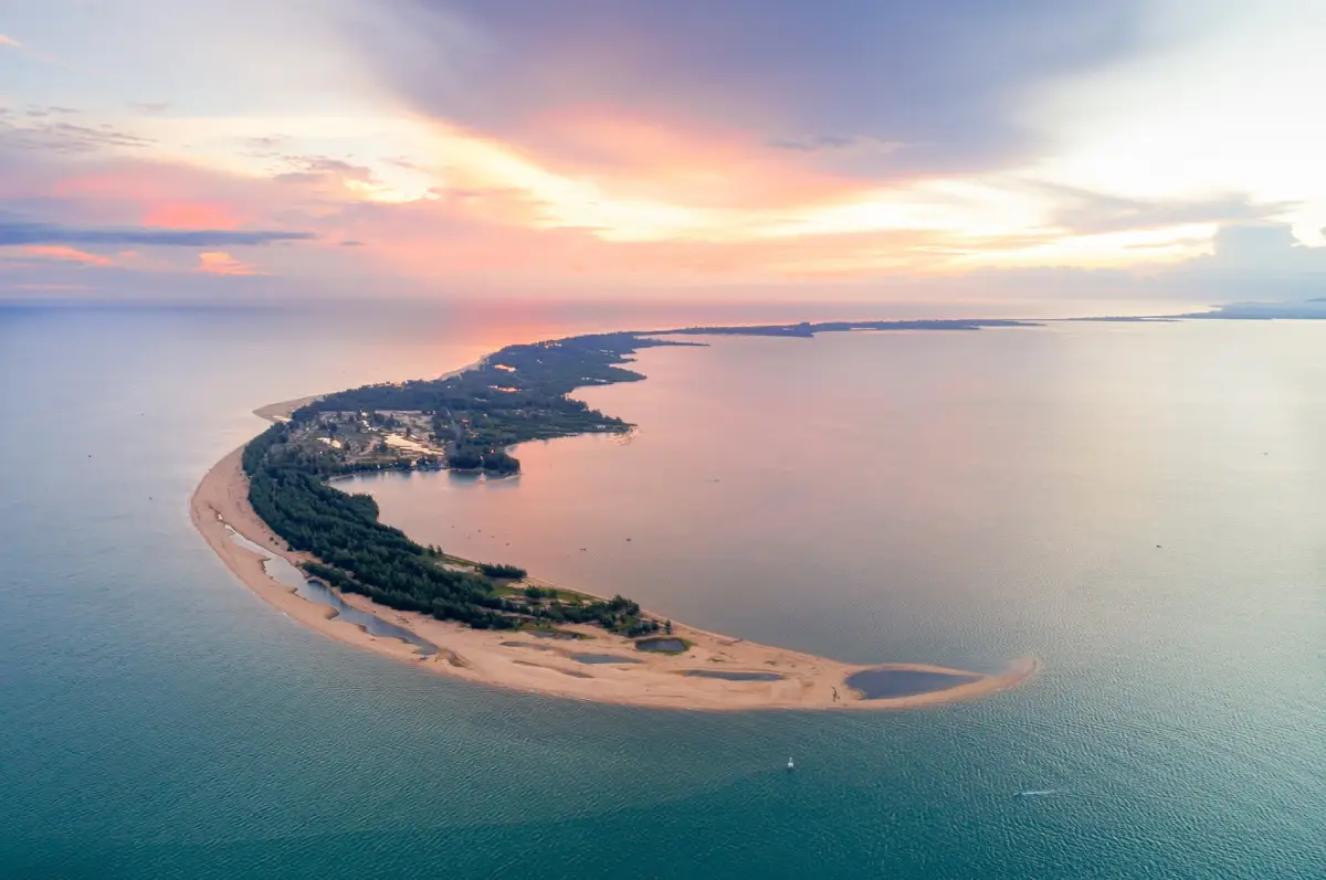
Laem Ta Chi, also known as Laem Pho, is one of the most distinctive coastal landforms in Yaring District, Pattani Province. It is a long white sandy cape extending from the coastal line beyond Hat Talo Kapo into the Gulf of Thailand. The cape was formed as a sand spit, a narrow sand ridge created by waves, currents, and sediment movement along the shoreline. Its long and curved shape separates the outer Gulf of Thailand from the inner Pattani Bay, creating a rare coastal landscape where beach, bay, mangrove, fishing community, and open sea can be experienced in one journey.
The most important feature of Laem Ta Chi is its natural formation. Over time, coastal currents have carried sand and deposited it along the shore, gradually forming a narrow cape that stretches into the sea. The tip of the cape curves like a hook, which is a classic feature of a sand spit. Because it is shaped by waves, wind, tides, and seasonal sediment movement, the coastline may look slightly different at different times of the year. This living coastal process is a key part of the attraction’s identity.
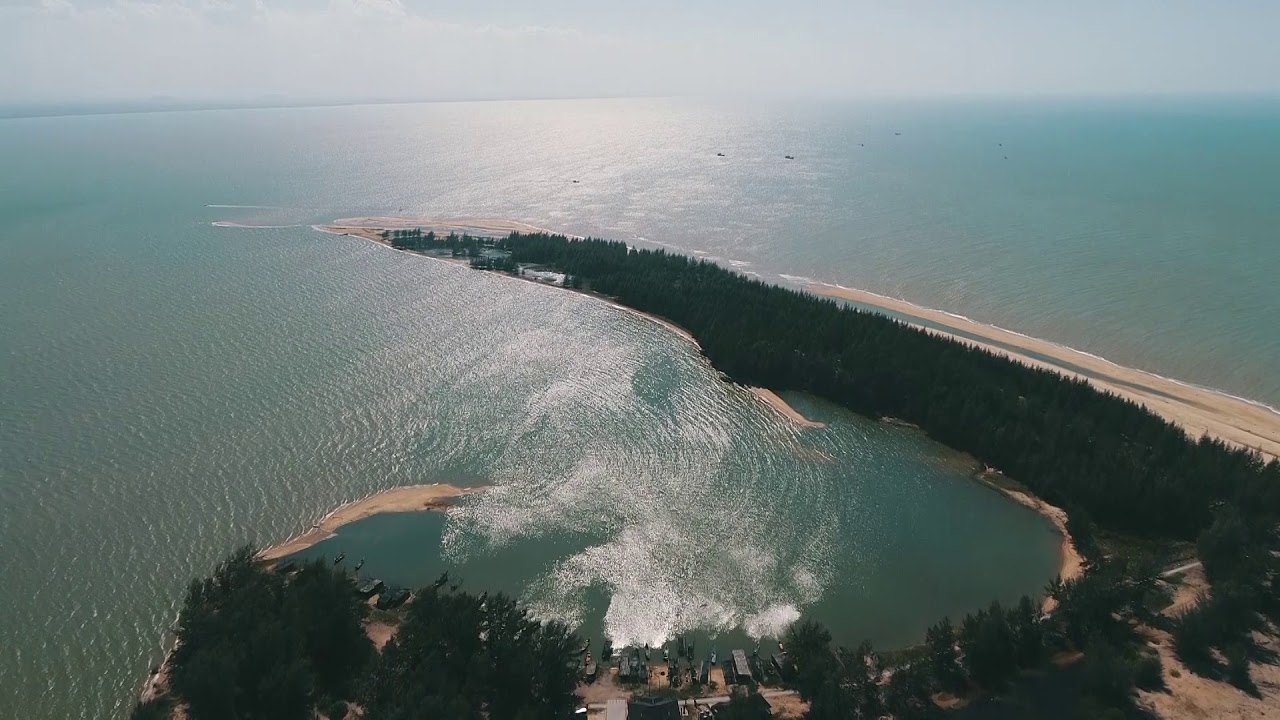
Laem Ta Chi is located in Laem Pho Subdistrict, Yaring District, Pattani Province. The cape connects with coastal communities such as Ban Dato, Ban Talo Samilae, and Ban Budi. The inner side faces Pattani Bay, where visitors can see communities, mangrove areas, and aquaculture zones. The outer side faces the open Gulf of Thailand. This gives the cape two different coastal moods: one calm and bay-facing, and the other open to the sea.
The name Laem Pho is linked with local memory. Older residents explain that the area once had many sacred fig trees, known in Thai as pho trees. Fishermen who came to work in these waters sometimes had to stay in the area when storms or strong waves made it impossible to return home. Temporary shelters were built, more people gradually settled here, and the area later became the present Laem Pho community. This story shows that Laem Ta Chi is not only a natural cape, but also a place shaped by migration, fishing life, and coastal settlement.
The name Laem Ta Chi is used for the new land that emerged from long-term sand accumulation. This sand-built land gradually extended into the sea and became the cape that is now one of Pattani’s most recognizable coastal destinations. Its meaning is therefore both geographical and cultural: it is a natural landform and a community landmark at the same time.
Geographically, Laem Ta Chi plays an important role in the coastal system of Pattani Bay. The sand spit helps reduce the force of monsoon wind and waves entering the bay. It contributes to a sheltered inner coastal environment that supports mangroves, fishing communities, and aquaculture. Standing at the cape gives visitors a clear view of how the outer sea, the inner bay, the sand ridge, and the community landscape are connected.
One of the most memorable things about Laem Ta Chi is that visitors can enjoy both sunrise and sunset from the same general area. Because the cape extends into open water and provides views on both sides, morning and evening light can be experienced in different directions. Sunrise gives the beach a fresh and quiet atmosphere, while sunset creates a softer mood over the bay and shoreline. This makes Laem Ta Chi one of Pattani’s most photogenic coastal viewpoints.
The best way to experience Laem Ta Chi is slowly. Walk along the sand, observe the shape of the cape, listen to the sea, watch the fishing boats, and look across the mangrove side of Pattani Bay. Unlike an ordinary beach with only one shoreline view, Laem Ta Chi combines a sand spit, open sea, inner bay, mangrove ecosystem, and fishing villages. This layered landscape gives the destination more depth than a simple seaside stop.
For photographers, Laem Ta Chi offers many strong visual elements: the long sand ridge, the curved tip of the cape, water on both sides, casuarina trees along parts of the route, fishing boats, mangrove views, sunrise, and sunset. Aerial images show the sand-spit shape most clearly, but even from ground level, visitors can sense the unusual geography through the road, the open water, and the narrowing landform near the tip.
Laem Ta Chi is also closely connected with the fishing communities of Yaring District. Local life here includes fishing, aquaculture, seafood trading, and daily use of the coastal environment. Visitors may see fishing boats, local equipment, seafood-related activities, and village life along the route. These scenes are not staged for tourism; they are part of how the community lives with the sea.
The inner bay side of the cape is associated with Pattani Bay, mangrove areas, and aquaculture such as sea bass, blood cockles, and mussels. This gives the cape ecological and economic importance. Mangroves serve as nursery grounds for aquatic life and help protect the coast, while aquaculture reflects the way local communities use the sheltered bay environment to support livelihoods.
Laem Ta Chi also has historical significance. Pattani’s coastline was part of key wartime events during World War II, and the Laem Ta Chi area is connected with stories of the 8 December 1941 landing and fighting along the coast. Today, most visitors come for nature, photography, and seaside rest, but this historical layer adds deeper meaning to the cape as part of Pattani’s coastal memory.
Suitable activities at Laem Ta Chi include beach walking, sunrise viewing, sunset viewing, photography, observing fishing life, relaxing by the sea, cycling along the coastal route, and taking boat trips through Pattani Bay. A boat trip offers a different view of the cape and makes it easier to understand the sand-spit shape, the mangroves, birdlife, and fishing communities around the bay.
Traveling by water is an interesting option. Boats can travel from the mouth of the Pattani River toward Laem Ta Chi, or from the Yaring pier route along Yamu Canal and into the inner sea before reaching the cape. This route is suitable for travelers who want to see Pattani Bay, mangroves, local boats, and coastal communities from the water. Visitors should arrange local boats in advance and check weather and sea conditions before departure.
Getting There by land from Pattani city is most convenient by private car or rental car. Follow Highway 42 on the Pattani–Narathiwat route, turn toward Yaring District, pass Yamu Canal and coastal communities, then continue along the Laem Pho route until reaching the tip of the cape. The driving distance from Pattani city to the cape is about 43 km. A private vehicle is recommended because visitors can also stop at Hat Talo Kapo, Ban Dato, Hat Talo Samilae, and other viewpoints along the way.
The route from Hat Talo Kapo to the tip of Laem Ta Chi is about 16 km. Along the way, visitors pass coastal communities, local houses, small resorts, tree-lined roads, and sea views in some sections. Driving slowly is recommended because the route passes through community areas shared by residents, motorcycles, visitors, and local business traffic.
The best times to visit are morning and late afternoon. Morning is suitable for sunrise, soft light, and observing the fishing community. Late afternoon is ideal for sunset, sea breeze, and photography. Visitors planning to stay near the cape should bring drinking water, snacks, sun protection, and a bag for taking rubbish back out, as facilities near the tip are limited compared with major tourist beaches.
Visitors should be careful near the sand spit and waterline. Laem Ta Chi is a natural coastal area where tide, waves, wind, and sand conditions change. Avoid walking onto wet or unstable sand when water is rising, avoid strong-current areas, and keep children close near the water. The safest way to enjoy the cape is to walk, observe, take photographs, and respect the natural conditions on the day of travel.
Responsible travel is essential at Laem Ta Chi. The area is a tourist destination, a natural sand-spit system, and a working landscape for local fishing communities. Visitors should not litter, disturb fishing boats or equipment, drive onto fragile sandy areas, or create unnecessary noise. If taking close-up photos of local people or boats, ask for permission first. Respectful behavior helps keep the place welcoming and sustainable.
Laem Ta Chi can be combined with several nearby attractions in Yaring District and Pattani city. A half-day route can start from Pattani city, continue to Hat Talo Kapo, then Laem Ta Chi, and return in the evening. A fuller day can add Laem Pho community tourism, Ban Dato Mosque, Yaring Mangrove Nature Study Center, Yaring Palace, and Krue Se Mosque. This route combines beach, mangrove, local history, architecture, and community life.
Hat Talo Kapo is one of the most suitable places to visit together with Laem Ta Chi because it is the beach line that connects with the cape. It is known for white sand, colorful Kor Lae fishing boats, and a strong fishing-community identity. Laem Pho community tourism adds local food, seafood, and community-based experiences. The Yaring mangrove area adds ecological context and helps visitors understand the inner bay system.
Food options around Laem Pho and Yaring include seafood restaurants, halal food shops, cafes, and local community food stops. The area is strongly associated with fresh seafood from coastal fishing. Travelers should plan meal stops in advance, especially when going to the cape for sunrise or sunset, because some local businesses operate according to community schedules and seasonal demand.
Accommodation around Laem Pho and nearby coastal communities includes homestays, local resorts, and small seaside stays. Staying nearby allows travelers to experience both morning and evening light at the cape. Those who prefer city services, larger hotels, and easier access to restaurants can stay in Pattani city and visit Laem Ta Chi as a day trip.
In summary, Laem Ta Chi or Laem Pho is one of Pattani’s most valuable coastal destinations. Its sand-spit formation, white sand, open sea views, sunrise and sunset viewpoints, fishing-community life, mangrove connection, and historical layers make it much more than a simple beach. For travelers who want to understand Pattani through nature, local communities, and coastal geography, Laem Ta Chi is a destination that deserves time and attention.
| Name | Laem Ta Chi / Laem Pho |
| Location | Laem Pho Subdistrict, Yaring District, Pattani Province |
| Address | Laem Pho Subdistrict, Yaring District, Pattani 94150, Thailand |
| Highlights | A white sandy sand spit extending into the Gulf of Thailand, sunrise and sunset viewpoints, Pattani Bay views, and Laem Pho fishing-community life |
| History / Importance | An important Pattani coastal landform created by sand deposition, separating Pattani Bay from the outer Gulf of Thailand and connected with the settlement history of Laem Pho fishing communities |
| Name Origin | Laem Pho is linked with local stories about many pho trees once found in the area, while Laem Ta Chi refers to newly formed land created by long-term sand accumulation near the cape |
| Distinctive Features | A long narrow sand spit with a curved hook-like tip, water on both sides, open coastal views, and a natural role in sheltering Pattani Bay from waves and monsoon wind |
| Main Areas / Zones | 1. Laem Ta Chi Cape Tip 2. White Sandy Beach And Sand Spit 3. Outer Gulf Of Thailand Side 4. Inner Pattani Bay Side 5. Laem Pho And Ban Dato Community Area 6. Fishing Boat And Aquaculture Area 7. Route Connecting Hat Talo Kapo And Yaring Mangrove Area |
| Travel Information | By land, follow Highway 42 from Pattani city toward Yaring District, pass Yamu Canal and coastal communities, then continue along Laem Pho to the cape tip. The distance is about 43 km from Pattani city. By water, boats can travel from the mouth of the Pattani River or from the Yaring pier route through Yamu Canal and the inner sea toward Laem Ta Chi |
| Current Status | Open as a natural attraction, public beach, and community recreation area in Yaring District |
| Open Days | Daily |
| Opening Hours | Open All Day |
| Facilities | Beach walking area, cape viewpoint, coastal driving route, photography spots, community tourism services, local boats, restaurants, and accommodation in Laem Pho and nearby communities |
| Caretaker | Laem Pho Subdistrict Administrative Organization and local agencies in Yaring District |
| Main Contact Number | 073-330-764 |
| Nearby Tourist Attractions | 1. Laem Pho Community Tourism Area, About 2 km 2. Ban Dato Mosque, About 4 km 3. Hat Talo Samilae, About 7 km 4. Hat Talo Kapo, About 16 km 5. Yaring Mangrove Nature Study Center, About 20 km 6. Yaring Palace, About 22 km 7. Krue Se Mosque, About 24 km |
| Nearby Restaurants | 1. Yasmi Seafood, About 3 km, Tel. 098-012-4091 2. Ban Dato Fish Cracker Group, About 5 km, Tel. 081-766-6167 3. Five Star PTT Talo Kapo, About 15 km, Tel. 081-098-2727 4. Phi Um Crab Fried Rice Yaring Branch, About 22 km, Tel. 081-963-7371 5. Deleaf Corner, About 22 km, Tel. 073-491-057 6. Beach Hut Coffee, About 23 km, Tel. 080-036-2063 |
| Nearby Accommodations | 1. Smilan Homestay, About 2 km, Tel. 098-064-6023 2. Taman Resort, About 4 km, Tel. 088-596-3203 3. Relax De Tuwah Beach Resort, About 18 km, Tel. 084-060-0060 4. Takadum Beach Resort, About 18 km, Tel. 098-707-1223, 093-579-6084 5. Pattanipirom Boutique Hotel, About 37 km, Tel. 081-698-3877 6. The Wood Pattani Hotel, About 39 km, Tel. 091-479-0666 |
Frequently Asked Questions (FAQ)
Q: Where is Laem Ta Chi / Laem Pho located?
A: Laem Ta Chi / Laem Pho is located in Laem Pho Subdistrict, Yaring District, Pattani Province. It is a sandy cape extending into the Gulf of Thailand and separating the inner Pattani Bay from the outer sea.
Q: What makes Laem Ta Chi special?
A: Its main feature is a sand spit formed by long-term sediment deposition. The cape extends into the sea, has water on both sides, and offers both sunrise and sunset views from the same general area.
Q: How can travelers get from Pattani city to Laem Ta Chi?
A: Follow Highway 42 on the Pattani–Narathiwat route toward Yaring District, pass Yamu Canal and coastal communities, then continue along Laem Pho to the cape tip. The distance is about 43 km from Pattani city.
Q: Can travelers reach Laem Ta Chi by boat?
A: Yes. Boats can travel from the mouth of the Pattani River or from the Yaring pier route through Yamu Canal and the inner sea toward Laem Ta Chi. Travelers should arrange local boats and check sea conditions before departure.
Q: What activities are suitable at Laem Ta Chi?
A: Suitable activities include beach walking, sunrise viewing, sunset viewing, photography, observing fishing life, cycling along the coastal route, and taking boat trips through Pattani Bay.
Q: When is the best time to visit Laem Ta Chi?
A: Morning is best for sunrise and soft light, while late afternoon is ideal for sunset, sea breeze, and photography around the cape.
Q: What should visitors be careful about?
A: Visitors should watch tide, waves, wind, and sand conditions, avoid unstable or water-surrounded sand areas, keep children close near the water, and avoid driving onto fragile sandy areas.
Q: Which nearby places can be visited with Laem Ta Chi?
A: Nearby places include Laem Pho community tourism area, Ban Dato Mosque, Hat Talo Samilae, Hat Talo Kapo, Yaring Mangrove Nature Study Center, Yaring Palace, and Krue Se Mosque.
 Category: ●Nature and Wildlife
 Group: ●Bays and Beaches
Last Update : 3 MonthAgo
 Last Update : 3 MonthAgo
 Click to Access the Navigation Map GPS
Laem Ta Chi (Laem Pho) Map

 Art, Culture and Heritage
 Historical Sites and Monuments(3)
 Landmarks and Memorials(7)
 Royal Palace(2)
 Art, Craft Centres, Tradition(7)
 Historic Homes and Cities(1)
 Educational Places
 Museum for Study(1)
 Training Center(1)
 University
 Public university(1)
 Private University(1)
 Places of Worship
 Temple(13)
 Mosque(5)
 Other Sacred Sites(4)
 Research and Development
 Royal Project(2)
 Suburban Living
 Village, Community(5)
 Local Market(2)
 National Parks and Marine Reserves(2)
 Mountain (Doi)(3)
 Waterfalls(3)
 River, Canal(2)
Bays and Beaches(13)
 Islands(2)
 Other natural attractions(1)
 Entertainment and Agricultural
 Farms, Parks and Ecotourism(1)
 Travel Articles, Recipes
 Travel Review, Food Review(1)
 Southern Food Menu, Southern Food Recipes(3)


