
lovethailand home >South Travel Attractions >Pattani Travel Attractions >Khok Pho >Sai Khao > Namtok Sai Khao National Park
TL;DR: Namtok Sai Khao National Park is located at Village No. 5, Sai Khao Subdistrict, Khok Pho District, Pattani Province 94120, open Daily, hours 08.30 – 16.30.

Namtok Sai Khao National Park
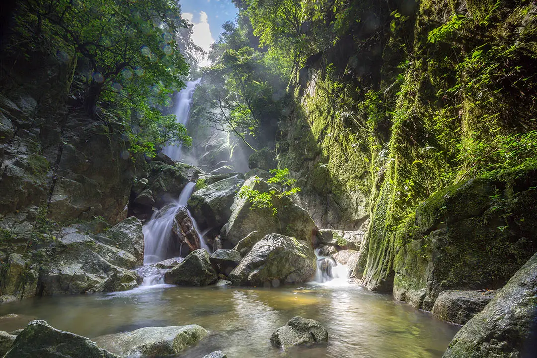
Open Days: Daily
Opening Hours: 08.30 – 16.30
Namtok Sai Khao National Park in Pattani Province is located in Village No. 5, Sai Khao Subdistrict, Khok Pho District. The park protects part of the Sankalakhiri mountain range across the border area of Pattani, Yala, and Songkhla provinces. Covering approximately 43,482 rai, it is a humid tropical forest and an important watershed of the Thepha River system. Key attractions include Sai Khao Waterfall, Phong Phong Waterfall, Aranwarin Waterfall, Phra Mai Phai Waterfall, Kae Dae Waterfall, Pha Phaya Ngu, Khao Rangkiap viewpoint, and Sai Khao community-based tourism.
Namtok Sai Khao National Park is one of Pattani’s most important natural attractions. It is located in Sai Khao Subdistrict, Khok Pho District, within the Sankalakhiri mountain range of Thailand’s lower southern region. The park is best known for Sai Khao Waterfall, where water drops from a cliff around 40 meters high before flowing down a series of forested rock levels into clear pools. The combination of waterfall, rainforest, streams, cliffs, and nearby community culture makes this park more than a simple swimming spot. It is a place for relaxation, nature education, watershed learning, and community-based travel.
The park covers forest areas in Khok Pho District of Pattani Province, Mueang Yala and Yaha districts of Yala Province, and parts of the Sankalakhiri forest in Saba Yoi District of Songkhla Province. Current park-related sources list the area at approximately 68.57 square kilometers, or 43,482 rai. The forest is the source of many streams, including Huai Sai Khao, Huai Phong Phong, Huai Bon, Huai Kae Dae, Huai Lam Yang, Huai Khlong Ruea, Huai Ton Takhian, Huai Lam Khing, and Huai Lam Phraya. These streams eventually join to form the Thepha River, showing the park’s importance as both a tourist destination and a southern watershed.
The landscape is mountainous, humid, and rich in tropical forest. Dense trees, streams, mossy rocks, ferns, and shaded trails create a cool atmosphere around the waterfalls. Visitors entering the waterfall area will notice a clear change from the urban environment of Pattani. The sound of falling water, insects, birds, and flowing streams creates a natural setting suitable for families, students, nature photographers, and travelers seeking a quieter side of Pattani.
Sai Khao Waterfall is the main attraction and the location of the park office area. The waterfall was formerly known locally as Namtok Krathon, and another traditional name associated with it is Namtok Takon. Its history is connected with Phra Khru Sri Rattanakon, also known as Than Si Kaeo, a former abbot of Wat Sai Khao. Around 1932, he encouraged local villagers to improve the area around the waterfall so that it could be accessed and enjoyed more easily. This history gives the waterfall cultural depth because it links natural beauty with local religious life and community effort.
The waterfall falls from a cliff approximately 40 meters high and then descends through a series of rock levels, creating pools and stream sections below. Several areas along the stream have local names, including Wang Sa Hua Nak, Wang Hin Dan, Wang Rom Sai, and Wang Thamnop. Each section has a different atmosphere. Some are suited for resting, some for photography, and some for cautious water play. The waterfall’s beauty comes not only from the main drop but also from the surrounding forest, stone surfaces, roots, ferns, and filtered natural light.
Phong Phong Waterfall is another important attraction in the park. It is located in Pak Lo Subdistrict, Khok Pho District, and is associated with the park protection unit No. 1. The waterfall descends in 7 staircase-like levels. At the lowest level, there is a large pool, and from below visitors can see the water winding down the upper cliff and rocks. The streamside area is covered by diverse vegetation, making the atmosphere shaded, cool, and suitable for quiet rest.
Aranwarin Waterfall is located in Village No. 4, Thung Phla Subdistrict. It is also part of the Sankalakhiri mountain system and consists of 7 levels. The distance between levels is around 300 to 500 meters, and each level has its own character. Some sections have streams flowing across boulders, some have pools, and some are framed by cliffs and dense forest. It is suitable for visitors who enjoy walking through natural waterfall landscapes in stages.
Other waterfalls in the park include Phra Mai Phai Waterfall and Kae Dae Waterfall. Together with Sai Khao, Phong Phong, and Aranwarin waterfalls, they show that this park is not centered on only one waterfall. It protects a wider stream-and-waterfall system created by the same forested mountain range. Visitors can choose which sites to explore depending on time, fitness, weather, and road conditions.
Pha Phaya Ngu is one of the park’s most distinctive natural landmarks. It is located near the route up to Khao Rangkiap viewpoint. The formation is a large rock roughly the height of a 3- to 4-storey building, shaped like the head of a giant serpent emerging from the cliff. Its unusual shape was created by natural geological processes and weathering. Local belief sees the rock as a benevolent serpent spirit that protects villagers and visitors. This makes Pha Phaya Ngu both a geological feature, a photography point, and a place connected with local belief.
Khao Rangkiap viewpoint and the morning mist area add another layer to the park. The area offers mountain scenery and views across the forested border region of Pattani, Yala, and Songkhla. It is also associated with Phra Phuttha Maha Muni Lokkanat and the local shrine of Thuat Rangkiap, both respected by the Sai Khao community. This route is suitable for visitors who want to combine forest scenery, viewpoints, and local spiritual heritage.
Sai Khao community-based tourism is an important part of a complete trip to the national park. Ban Sai Khao is a multicultural community where Thai Buddhist and Thai Muslim residents have lived together for generations. The village lies near the foot of the Sankalakhiri mountains and close to the national park. It received recognition as an outstanding tourism community through the Thailand Tourism Award 2007. Local activities include trekking to the Sankalakhiri mountain area, riding vintage jeeps, visiting seasonal fruit orchards, learning local wisdom, observing Juan Tani textile weaving, and experiencing a simple rural lifestyle.
Community products from Ban Sai Khao include Juan Tani cloth, processed banana strips, dried garcinia, garcinia sweets, garcinia tea, and premium local durian. Visiting the community after the waterfall helps travelers understand the area more completely. The journey can connect watershed forest, waterfall, orchard, craft, local food, and household enterprise in one route. This form of travel supports both conservation and the local economy.
For water activities, Sai Khao Waterfall is the most accessible and popular site. It has a park service area, staff presence, rest areas, and natural pools. Still, waterfall safety is essential. Visitors should avoid entering strong currents, slippery rock areas, or sections not recommended by park staff. After heavy rain, water levels can rise quickly, and travelers should follow all warning signs and staff instructions.
For visitors interested in nature study, the park offers forest trails and tropical rainforest environments. Good footwear, drinking water, and suitable clothing are important. Staying on marked routes protects both visitors and the forest. The park environment is suitable for observing plants, birds, butterflies, small wildlife, mosses, ferns, rock formations, and watershed streams.
The best time to visit depends on weather and water conditions. The rainy and post-rainy periods often bring more water to the falls, but visitors should always check weather conditions and park announcements before traveling. Mornings are generally the best time for photography, walking, and enjoying the cooler atmosphere. Families should allow enough time for resting, changing clothes, and walking carefully in sloped or wet areas.
Visitors should dress for a natural waterfall environment. Non-slip shoes or sandals with straps are recommended. Quick-drying clothes, towels, spare clothes, and waterproof protection for cameras or phones are useful. Families traveling with children or older adults should choose areas near the main service zone and avoid steep routes that exceed their comfort level.
Responsible travel is essential in a national park. Visitors should not litter, remove plants, disturb wildlife, make unnecessary noise, bring pets into forest areas, or start fires outside permitted zones. Namtok Sai Khao National Park is a watershed and a habitat for many living organisms. Keeping the park clean helps preserve its ecological value for future visitors and local communities.
Getting There from Pattani city is straightforward. Take Highway 409, the Pattani – Yala route, for about 28 km to the Na Pradu junction in Khok Pho District. From there, continue along the Na Pradu – Sai Khao road for about 7 km to reach Sai Khao Waterfall and the park office area. To visit Phong Phong Waterfall, use Highway 42 and Highway 409 to Ban Pak Lo, then turn onto a paved road for about 5 km to the waterfall.
A one-day itinerary can begin at Sai Khao Waterfall in the morning, followed by rest, photography, and light water activities. Visitors can then continue to Ban Sai Khao community for local products or community learning. With more time, the route can include Khao Rangkiap viewpoint, Pha Phaya Ngu, Phong Phong Waterfall, or Wat Chang Hai. Travelers who want a deeper experience can stay overnight in park accommodation, a camping area, or Ban Sai Khao homestay.
Namtok Sai Khao National Park is suitable for many types of travelers. Families can relax and play safely in appropriate areas. Students can learn about rainforest ecology and watersheds. Photographers can capture waterfalls, cliffs, greenery, and community life. Cultural travelers can combine the park with Ban Sai Khao, Wat Sai Khao, Wat Chang Hai, Najmuddin Mosque, and nearby multicultural communities.
In summary, Namtok Sai Khao National Park brings together waterfalls, tropical forest, the Sankalakhiri mountains, watershed streams, viewpoints, local legends, and community tourism. Its value is not limited to the 40-meter waterfall or scenic pools. The park represents the relationship between forest, water, geology, community, and local culture. For anyone seeking the natural side of Pattani, this national park should be one of the main places to visit.
| Name | Namtok Sai Khao National Park |
| Location | Village No. 5, Sai Khao Subdistrict, Khok Pho District, Pattani Province 94120 |
| Address | Namtok Sai Khao National Park, Village No. 5, Sai Khao Subdistrict, Khok Pho District, Pattani Province 94120 |
| Coordinates | Latitude 6.6576226, Longitude 101.0943695 |
| Highlights | Sai Khao Waterfall, Phong Phong Waterfall, Aranwarin Waterfall, Phra Mai Phai Waterfall, Kae Dae Waterfall, Pha Phaya Ngu, Khao Rangkiap Viewpoint, tropical forest, and Ban Sai Khao community tourism |
| History / Importance | Sai Khao Waterfall was formerly known as Namtok Krathon and is associated with Phra Khru Sri Rattanakon, or Than Si Kaeo, a former abbot of Wat Sai Khao, who encouraged local residents to improve the waterfall area around 1932. The area later developed into a national park. |
| Area Size | Approximately 68.57 square kilometers, or 43,482 rai |
| Landscape | Humid tropical forest in the Sankalakhiri mountain range and an important watershed feeding streams that join the Thepha River system |
| Travel Information | From Pattani city, take Highway 409 toward Yala for about 28 km to the Na Pradu junction, then continue on the Na Pradu – Sai Khao road for about 7 km to reach Sai Khao Waterfall |
| Current Status | Open as a national park attraction under the Department of National Parks, Wildlife and Plant Conservation |
| Open Days | Daily |
| Opening Hours | 08.30 – 16.30 |
| Fees | Thai Adults 20 Baht, Thai Children 10 Baht / Foreign Adults 100 Baht, Foreign Children 50 Baht / Car 30 Baht Per Vehicle / Motorcycle 20 Baht Per Vehicle |
| Managing Authority | Department Of National Parks, Wildlife And Plant Conservation, through Namtok Sai Khao National Park, Pattani Province |
| Contact Number | 073-420-295 |
| Facilities | Park staff, park accommodation, camping area, parking area, toilets, rest areas, nature trails, and wheelchair service in the main service area |
| Main Areas / Zones | 1. Sai Khao Waterfall And Park Office Area 2. Phong Phong Waterfall And Protection Unit No. 1 3. Aranwarin Waterfall 4. Phra Mai Phai Waterfall 5. Kae Dae Waterfall 6. Pha Phaya Ngu 7. Khao Rangkiap Viewpoint And Morning Mist Area 8. Ban Sai Khao Community Tourism Area |
| Nearby Tourist Attractions | 1. Sai Khao Waterfall Viewpoint, about 0.3 km 2. Ban Sai Khao Community Tourism Area, about 1 km 3. Najmuddin Mosque, or the 300-Year Mosque, about 2 km 4. Wat Sai Khao, about 2 km 5. Wat Rat Burana, or Wat Chang Hai, about 9 km 6. Phong Phong Waterfall, about 15 km 7. Aranwarin Waterfall, about 15 km |
| Nearby Restaurants | 1. Met Thorathat Na Pradu Restaurant, about 8 km, Tel. 080-434-1581 2. Khao Kaeng Pa Dee Khok Sung, about 10 km, Tel. 086-961-1506, 073-415-215 3. Ninu Noodle Halal Khok Pho, about 13 km, Tel. 090-476-6971 4. Krua Nai Ban Khok Pho, about 13 km, Tel. 086-295-4159 5. nikuma cafe’ kokpho, about 14 km, Tel. 062-287-7275 6. OH MY CHA Khok Pho, about 14 km, Tel. 097-496-9464 |
| Nearby Accommodations | 1. Namtok Sai Khao National Park Accommodation And Camping Area, inside the park, Tel. 073-420-295 2. Ban Sai Khao Homestay, about 1 km, Tel. 081-097-7025 3. Ban Sai Khao Community, about 1 km, Tel. 089-737-9553 4. Rungtawan Resort Khok Pho, about 13 km, Tel. 073-330-668 5. Chom Chan Resort, about 14 km, Tel. 086-966-0836, 073-431-849 6. Southern View Hotel Pattani, about 31 km, Tel. 073-450-570 |
Frequently Asked Questions (FAQ)
Q: Where is Namtok Sai Khao National Park located?
A: Namtok Sai Khao National Park is located in Village No. 5, Sai Khao Subdistrict, Khok Pho District, Pattani Province. It protects part of the Sankalakhiri mountain range across Pattani, Yala, and Songkhla.
Q: What time does Namtok Sai Khao National Park open?
A: The park opens daily from 08.30 to 16.30. Morning visits are recommended for walking, photography, and waterfall activities.
Q: What are the entrance fees?
A: Entrance fees are 20 baht for Thai adults, 10 baht for Thai children, 100 baht for foreign adults, and 50 baht for foreign children, with additional vehicle fees under national park regulations.
Q: Is Sai Khao Waterfall suitable for swimming?
A: Sai Khao Waterfall has natural pools and stream areas suitable for relaxing and water play in safe zones. Visitors should follow park staff instructions, especially during or after heavy rain.
Q: What waterfalls are inside the park?
A: The park includes Sai Khao Waterfall, Phong Phong Waterfall, Aranwarin Waterfall, Phra Mai Phai Waterfall, and Kae Dae Waterfall, along with Pha Phaya Ngu and Khao Rangkiap viewpoint.
Q: How do visitors get to Namtok Sai Khao National Park?
A: From Pattani city, take Highway 409 toward Yala for about 28 km to the Na Pradu junction, then continue on the Na Pradu – Sai Khao road for about 7 km to reach the park.
Q: Are there accommodations near the park?
A: Park accommodation, a camping area, Ban Sai Khao homestay, and several accommodations in Khok Pho and Pattani city are available. Travelers should contact the accommodation in advance.
Q: What nearby places can be combined with the park?
A: Nearby places include Ban Sai Khao community tourism area, Najmuddin Mosque, Wat Sai Khao, Wat Chang Hai, Phong Phong Waterfall, and Aranwarin Waterfall.
 Category: ●Nature and Wildlife
 Group: ●National Parks and Marine Reserves
Last Update : 4 WeekAgo
 Last Update : 4 WeekAgo
 Click to Access the Navigation Map GPS
Namtok Sai Khao National Park Map

 Art, Culture and Heritage
 Historical Sites and Monuments(3)
 Landmarks and Memorials(7)
 Royal Palace(2)
 Art, Craft Centres, Tradition(7)
 Historic Homes and Cities(1)
 Educational Places
 Museum for Study(1)
 Training Center(1)
 Places of Worship
 Temple(13)
 Mosque(5)
 Other Sacred Sites(4)
 Research and Development
 Royal Project(2)
 Suburban Living
 Village, Community(5)
 Local Market(2)
National Parks and Marine Reserves(2)
Local Market(2)
National Parks and Marine Reserves(2)
 Mountain (Doi)(3)
 Waterfalls(3)
 River, Canal(2)
 Bays and Beaches(13)
 Islands(2)
 Other natural attractions(1)
 Entertainment and Agricultural
 Farms, Parks and Ecotourism(1)
 Travel Articles, Recipes
 Travel Review, Food Review(1)
 Southern Food Menu, Southern Food Recipes(3)


