
lovethailand home >South Travel Attractions >Chumphon Travel Attractions >Muang Chumphon >Tha Taphao > Mu Ko Chumphon National Park
TL;DR: Mu Ko Chumphon National Park is located at Hat Sai Ri Subdistrict, Mueang Chumphon District, Chumphon Province, with protected coastal and island areas across Pathio, Mueang, open Daily, hours 08.00 - 16.30.
Mu Ko Chumphon National Park
Open Days: Daily
Opening Hours: 08.00 - 16.30
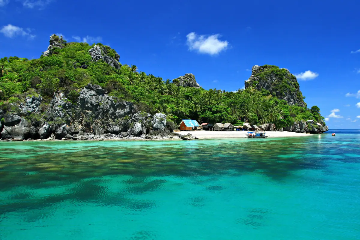
Mu Ko Chumphon National Park is one of the most important marine national parks in Chumphon Province. Covering about 198,125 rai, or 317 square kilometres, it was originally developed from the former Hat Sai Ri National Park concept and was officially declared Mu Ko Chumphon National Park on 24 February 1999. The park stretches across coastal and island areas from Pathio, Mueang Chumphon, Sawi, Thung Tako, and Lang Suan Districts. Its landscapes include mangrove forest, mountains, beaches, sea, coral reefs, and more than 40 islands. Key attractions include the mangrove nature trail at Thung Kha Bay, the visitor centre connected by wooden boardwalks, boat and kayak routes, Ko Ngam Noi, Ko Ngam Yai, Ko Mattra, Ko Langka Chio, Ko Maphrao, Ko Thong Lang, Ko Rang Ka Chio, Thung Makham Bay, Hat Sai Ri, and Khao Chao Mueang Viewpoint. The park is ideal for nature walks, kayaking, birdwatching, mangrove study, snorkeling, scuba diving, island trips, and learning about Chumphon’s marine ecosystem.
Mu Ko Chumphon National Park represents Chumphon’s coastal identity very clearly. The province is often seen as a gateway to southern Thailand, but the park shows that Chumphon is also a major marine-ecology destination with islands, coral reefs, beaches, mangroves, and coastal communities. The park is not only a place for boat trips or snorkeling; it is a large conservation area where sea, forest, beach, island, and reef systems are connected.
The park’s history is important. The area was first associated with Hat Sai Ri National Park before the conservation scope expanded to include a wider network of islands, mangrove forest, and coastal ecosystems. On 24 February 1999, the area was officially declared Mu Ko Chumphon National Park under a royal decree covering Thung Kha Bay mangrove forest, Ao Sawi forest, and many islands along Chumphon’s coast. This declaration gave the area a stronger formal conservation status.
The national park extends along a long section of Chumphon’s coastline. It begins from the northern island area around Ko Chorakhe in Pathio District, continues through important islands in Mueang Chumphon such as Ko Ngam Yai, Ko Ngam Noi, Ko Samet, Ko Maphrao, Ko Mattra, Ko Thong Lang, and Ko Rang Ka Chio, and extends southward to areas in Sawi, Thung Tako, and Lang Suan. This makes the park a coastal and marine network rather than a single attraction.
The park headquarters is located in Hat Sai Ri Subdistrict, Mueang Chumphon District. Its most distinctive feature is its mangrove setting near Thung Kha Bay. The visitor centre and wooden boardwalks allow visitors to explore the mangrove environment without damaging the fragile soil and root systems. Along the trails, visitors can observe mangrove plants, tidal water movement, crabs, fish, birds, and small animals that depend on the mangrove forest for shelter and nursery habitat.
The mangrove forest is one of the most important parts of the park. It acts as a natural buffer between land and sea, reduces coastal erosion, traps sediment, and provides nursery grounds for young marine life. Walking on the boardwalk is therefore more than a scenic activity; it is a chance to see how a coastal ecosystem protects the shoreline and supports marine biodiversity.
The mangrove nature trail is suitable for families, students, nature learners, and visitors who want a gentle experience without going out to sea. Visitors should remain on the designated boardwalk, avoid stepping into the forest floor, avoid disturbing animals, and keep the area clean. The value of this area depends on careful visitor behaviour.
Boat and kayak activities around the mangrove channels provide another view of the ecosystem. From the water, visitors can see how mangrove roots, tidal canals, and Thung Kha Bay connect. When conditions are suitable, this is a good way to learn about tidal rhythms, river-mouth environments, and the role of mangrove forests in local coastal life.
The park also includes several beaches and coastal bays. Important coastal areas include Thung Makham Nai, Thung Makham Nok, Hat Sai Ri, Hat Arunothai, and beaches in Sawi, Thung Tako, and Lang Suan districts. These areas are connected to fishing communities, boat routes, viewpoints, and island trips, making the park more diverse than a snorkeling-only destination.
Hat Sai Ri is especially important because it is linked with the Prince of Chumphon Khet Udomsak Shrine and Khao Chao Mueang Viewpoint. From the viewpoint, visitors can see islands scattered across Chumphon’s sea, giving a clearer understanding of the park’s geography. The islands are not isolated attractions; they form one marine landscape connected with beaches, mangroves, and coral reefs.
The marine area contains more than 40 islands. Well-known islands include Ko Ngam Noi, Ko Ngam Yai, Ko Mattra, Ko Langka Chio, Ko Maphrao, Ko Thong Lang, Ko Rang Ka Chio, and Ko Kula. Each island has a different character. Some are known for coral reefs, some for fine sand, some for historical associations, and some for special conservation or access conditions. Visitors should choose island routes according to season, sea conditions, and park regulations.
Ko Ngam Noi and Ko Ngam Yai are commonly associated with snorkeling and diving routes. Ko Langka Chio is important both naturally and historically. Ko Maphrao is linked with swiftlet-nest concession areas and has specific access conditions. Visitors should not assume that every island can be entered freely. Some areas require permission, a guide, or prior coordination with the park or local authorities.
Snorkeling and scuba diving are among the park’s major attractions. The reefs around the islands support hard coral, soft coral, gorgonians, sea anemones, reef fish, and other marine life. However, coral reefs are fragile. Visitors should not step on coral, touch marine animals, feed fish, collect shells or coral, or leave waste in the sea. Responsible behaviour is essential for keeping the reefs healthy.
The best time for marine travel depends on sea conditions. The park has previously closed marine attractions and islands during rough monsoon periods for safety, then reopened them when conditions improved. Visitors planning boat trips should always check the latest park announcements, especially during the northeast monsoon period around late year, when rough seas can affect travel and safety.
Entrance fees follow the national park fee structure. For Thai visitors, the fee is 40 baht for adults and 20 baht for children. For foreign visitors, the fee is 200 baht for adults and 100 baht for children. Vehicle fees are charged separately according to vehicle type, and boat, snorkeling, diving, and tour-operator costs are separate from park admission.
The park headquarters provides a visitor centre, accommodation, camping areas, and related facilities under the national-park system. Visitors who want to stay overnight should check the official booking system or contact the park directly because capacity is limited and some areas may be affected by weather, maintenance, or conservation measures.
Getting There from Chumphon town is straightforward by private car, rental car, or local transport. Take Highway 4001 from Chumphon town toward Pak Nam, continue on Highway 4119 to the Pak Nam Subdistrict junction, turn right onto Highway 4098 for about 100 metres, then turn right onto Highway 4017 and continue for about 9 km to the park headquarters. The total distance from Chumphon town is about 23 km.
For island trips, visitors should contact the park or use operators that follow safety and park regulations. Boats should have enough life jackets, safety equipment, knowledge of sea conditions, and experience with the island routes. Safety and compliance with park rules are more important than the number of islands included in a tour.
Visitors with only half a day can focus on the park headquarters, mangrove boardwalk, visitor centre, and nearby coastal attractions such as Hat Sai Ri, the Prince of Chumphon Shrine, and Khao Chao Mueang Viewpoint. This route is suitable for families, elderly visitors, and those who prefer not to depend on sea conditions.
Visitors with a full day can add kayaking, boat trips, or snorkeling routes when weather and park conditions allow. With two days and one night, it is possible to divide the trip into a mangrove-and-coast day and an island-and-snorkeling day. This gives a fuller understanding of the park than a rushed day trip.
Visitor responsibility is essential. Do not litter, do not bring unnecessary single-use plastic into the sea, do not touch marine animals, do not step on coral, do not collect shells or natural materials, do not feed fish, and do not enter closed or restricted areas. Marine national parks can remain beautiful only when visitors reduce their impact.
As an educational destination, Mu Ko Chumphon National Park clearly shows the relationship between mangrove forests, islands, beaches, sea, and coral reefs. Mangroves protect the coast and nurture marine life. Islands provide habitats and scenery. Beaches connect communities with the sea. Coral reefs shelter countless organisms. These elements form one linked ecosystem that requires careful protection.
Overall, Mu Ko Chumphon National Park is one of the best places to understand Chumphon beyond its role as a transit province. It combines mangrove forest, beaches, islands, coral reefs, marine biodiversity, coastal culture, and formal conservation management in one large protected area. A good visit should be more than photography or snorkeling; it should be a respectful encounter with one of the Gulf of Thailand’s valuable marine ecosystems.
| Name | Mu Ko Chumphon National Park |
| Location | Hat Sai Ri Subdistrict, Mueang Chumphon District, Chumphon Province, with protected coastal and island areas across Pathio, Mueang Chumphon, Sawi, Thung Tako, and Lang Suan Districts |
| Park Headquarters Address | 1/4 Moo 5, Hat Sai Ri Subdistrict, Mueang Chumphon District, Chumphon 86120, Thailand |
| Park Headquarters Coordinates | 10.3568704, 99.2295399 |
| Contact Number | 077-558-144 |
| Park Chief | Mr. Khemmachat Chuai Mueang |
| Park Area | About 198,125 rai, or 317 square kilometres |
| National Park Declaration | Officially declared Mu Ko Chumphon National Park on 24 February 1999 |
| Highlights | Thung Kha Bay mangrove forest, wooden boardwalks, visitor centre, more than 40 islands, coral reefs, Ko Ngam Noi, Ko Ngam Yai, Ko Mattra, Ko Langka Chio, Ko Maphrao, Ko Thong Lang, Ko Rang Ka Chio, Thung Makham Bay, Hat Sai Ri, and Khao Chao Mueang Viewpoint |
| Main Ecosystems | Mangrove Forest, Mountains, Beaches, Sea, Islands, Coral Reefs, And Marine Wildlife Habitat |
| Open Days | Daily |
| Opening Hours | 08.00 - 16.30 |
| Entrance Fee | Thai Visitors: Adult 40 Baht, Child 20 Baht Foreign Visitors: Adult 200 Baht, Child 100 Baht Vehicle Fees, Boat Fees, And Marine Activity Fees Are Charged Separately Depending On Service Type |
| Travel Information | From Chumphon town, take Highway 4001 toward Pak Nam, continue on Highway 4119 to Pak Nam Subdistrict junction, turn right onto Highway 4098 for about 100 metres, then turn right onto Highway 4017 and continue about 9 km to the park headquarters. The total distance is about 23 km. |
| Current Status | Open for tourism and overnight stay under the latest reopening announcement from 16 December 2025 onward. Marine attractions and islands may still close seasonally, during monsoon conditions, or under conservation measures, so visitors should check park announcements before boat travel. |
| Main Areas / Zones | 1. Park Headquarters And Visitor Centre 2. Thung Kha Bay Mangrove Nature Trail 3. Mangrove Canal And Boat/Kayak Area 4. Beaches And Coastal Bays 5. Islands And Diving Sites 6. Accommodation, Camping, And Overnight Areas 7. Ranger Units On Islands And Coastal Areas |
| Recommended Activities | Mangrove Nature Walks, Boat Trips, Kayaking, Birdwatching, Plant Observation, Photography, Camping, Snorkeling, Scuba Diving, Coral Reef Viewing, And Seasonal Island Trips |
| Visitor Guidelines | Do Not Litter, Do Not Touch Marine Animals, Do Not Step On Coral, Do Not Collect Coral, Shells, Or Natural Materials, Do Not Feed Fish, Wear A Life Jacket On Boats, And Follow Park Officer Instructions Strictly |
| Nearby Tourist Attractions | 1. Hat Sai Ri And Prince Chumphon Shrine, About 6 km 2. Khao Chao Mueang Viewpoint, About 6 km 3. Thung Makham Nai And Thung Makham Nok Bays, About 8 km 4. Paradonpab Beach, About 12 km 5. Lomprayah Pier Chumphon, About 14 km 6. Khao Matsee Viewpoint, About 18 km |
| Nearby Restaurants | 1. The Seaside Tha Ruea, About 0.3 km 2. Nong Mai Sai Ri Beach Resort Restaurant, About 6 km 3. Pad Thai Thad Ban Mor Taew, About 6 km 4. Seafood Restaurants Around Hat Sai Ri, About 6 km 5. Restaurants Around Thung Makham Bay, About 8 km 6. Restaurants Around Pak Nam Chumphon, About 15 km |
| Nearby Accommodations | 1. Mu Ko Chumphon National Park Accommodation, In The Park, Tel. 077-558-144 2. Hat Sai Resort, About 6 km, Tel. 077-558-028 3. Sai Ree Beach Cabana, About 6 km 4. Koidolare Resort Chumphon, About 5 km, Tel. 099-454-5534 5. Moonshine Resort Chumphon, About 3 km 6. M.T. Resort, About 10 km, Tel. 077-558-153 |
Frequently Asked Questions (FAQ)
Q: Where Is Mu Ko Chumphon National Park Located?
A: The park headquarters is at 1/4 Moo 5, Hat Sai Ri Subdistrict, Mueang Chumphon District, Chumphon Province. The protected area covers coastal and island zones across Pathio, Mueang Chumphon, Sawi, Thung Tako, and Lang Suan Districts.
Q: What Are The Opening Days And Hours?
A: The park is open daily from 08.00 to 16.30, but marine attractions and islands may close seasonally or during rough sea conditions. Visitors should check official park announcements before traveling by boat.
Q: How Much Is The Entrance Fee?
A: Thai visitors pay 40 baht for adults and 20 baht for children. Foreign visitors pay 200 baht for adults and 100 baht for children. Vehicle fees, boat fees, and marine activity fees are charged separately.
Q: What Are The Main Highlights Of The Park?
A: The main highlights are the Thung Kha Bay mangrove nature trail, wooden boardwalks, more than 40 islands, coral reefs, snorkeling and diving sites, Hat Sai Ri, Thung Makham Bay, and Khao Chao Mueang Viewpoint.
Q: What Activities Can Visitors Do?
A: Visitors can walk through mangrove forest, take boat trips, paddle kayaks, watch birds, take photos, camp, snorkel, scuba dive, view coral reefs, and visit islands when conditions allow.
Q: How Do Travelers Get There From Chumphon Town?
A: Travel by Highway 4001 toward Pak Nam, continue on Highway 4119, turn onto Highway 4098, then Highway 4017 for about 9 km to the park headquarters. The total distance from Chumphon town is about 23 km.
Q: When Is The Best Time To Visit?
A: The best period for marine activities is when sea conditions are calm. Visitors should be especially careful during late-year monsoon conditions and always check current park announcements before booking boat trips.
Q: What Nearby Places Can Be Combined With A Visit?
A: Nearby places include Hat Sai Ri, the Prince Chumphon Shrine, Khao Chao Mueang Viewpoint, Thung Makham Bay, Paradonpab Beach, Lomprayah Pier Chumphon, and Khao Matsee Viewpoint.
 Category: ●Nature and Wildlife
 Group: ●National Parks and Marine Reserves
Last Update : 1 MonthAgo
 Last Update : 1 MonthAgo
 Click to Access the Navigation Map GPS
Mu Ko Chumphon National Park Map
Gellery
Recommend

 Art, Culture and Heritage
 Historical Sites and Monuments(1)
 Landmarks and Memorials(2)
 Art, Craft Centres, Tradition(3)
 Museums(2)
 Educational Places
 Educational Gardens, Farm(1)
 Places of Worship
 Temple(31)
 Other Sacred Sites(9)
 Research and Development
 Royal Project(1)
 Suburban Living
 Village, Community(5)
 Local Market(1)
National Parks and Marine Reserves(7)
Local Market(1)
National Parks and Marine Reserves(7)
 Mountain (Doi)(5)
 Dam, Reservoir, Lake(1)
 Waterfalls(26)
 Hot Springs(1)
 Caves(21)
 River, Canal(7)
 Bays and Beaches(30)
 Islands(13)
 Other natural attractions(7)
 Entertainment and Agricultural
 Farms, Parks and Ecotourism(3)
 Outdoor and Adventure Activities(4)
 Shopping
 Shopping and Night Market(1)


