
lovethailand home >Eastern Travel Attractions >Chanthaburi Travel Attractions > Map of Eastern Thailand with Province Names
TL;DR: Map of Eastern Thailand with Province Names.

Map of Eastern Thailand with Province Names
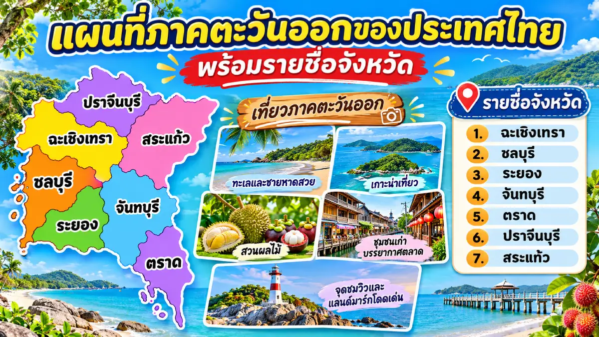
Map of Eastern Thailand with Province Names is a guide to understanding the locations of all seven provinces, their physical landscapes, river systems, coastal areas along the Gulf of Thailand, and major tourist attractions. Under Thailand’s six-region geographical classification, Eastern Thailand comprises Chanthaburi, Chachoengsao, Chon Buri, Trat, Prachin Buri, Rayong, and Sa Kaeo. The region stretches across the transition from the Central Plains to the eastern mountain ranges, the Thai–Cambodian border, and a coastline dotted with numerous islands. Anyone searching for a map of Eastern Thailand can use the provincial list and information on this page to understand how geography shapes travel, whether their interests lie in beaches, historic towns, important temples, forests, mountains, fruit orchards, or local communities.
How Many Provinces Are in Eastern Thailand? Eastern Thailand has seven provinces under the geographical classification of the National Geographical Committee: Chanthaburi (จันทบุรี), Chachoengsao (ฉะเชิงเทรา), Chon Buri (ชลบุรี), Trat (ตราด), Prachin Buri (ปราจีนบุรี), Rayong (ระยอง), and Sa Kaeo (สระแก้ว). This list is appropriate for a seven-province map of Eastern Thailand. However, readers may encounter maps showing eight provinces because classifications used for weather forecasting or economic development may also include Nakhon Nayok. Identifying the regional classification from the outset helps avoid confusion and allows maps produced by different organizations to be compared more accurately.
A map of Eastern Thailand reveals far more than the beaches and holiday islands commonly associated with the region. It also shows the Bang Pakong River floodplain and agricultural communities of Chachoengsao; the plains, mountain ranges, and forests of Prachin Buri and Sa Kaeo; and the mountains and foothill plains of Chanthaburi and Rayong, which are well suited to fruit cultivation. This diversity of landscapes gives each province a different economic and tourism role. Some areas have developed into industrial cities and transportation hubs, while others continue to preserve fishing communities, orchards, and historic settlements whose lives have long been connected with rivers.
How Many Provinces in Eastern Thailand Border the Sea? Five provinces have coastlines along the Gulf of Thailand: Chachoengsao, Chon Buri, Rayong, Chanthaburi, and Trat. Chachoengsao meets the Gulf at the mouth of the Bang Pakong River and has a coastal landscape quite different from a conventional beach resort. Chon Buri, Rayong, Chanthaburi, and Trat have widely known coastal destinations and islands. Prachin Buri and Sa Kaeo have no direct coastline; their tourism strengths instead lie in ancient towns, local culture, mountains, forests, and cross-border trade.
The terrain in the northern and northeastern parts of Eastern Thailand is associated with mountain ranges along the edge of the Khorat Plateau, including forest areas within the Dong Phayayen–Khao Yai forest complex. To the east and southeast lie the Chanthaburi and Banthat mountain ranges and important watershed forests. The distribution of mountains and plains means that some areas are mountain towns, others are fruit-growing areas and agricultural lowlands, and coastal areas include beaches, river mouths, mangrove forests, and fishing communities.
Eastern Thailand’s major rivers include the Bang Pakong River, which flows through Chachoengsao before entering the Gulf of Thailand; the Chanthaburi River, historically associated with the settlement and commerce of the Chanthaboon community; the Prasae River in Rayong; and the Trat River near the eastern coastline. These rivers have supported transportation and settlement for centuries. Many towns still contain old markets, temples, shrines, wooden buildings, and commercial districts that developed along their banks. Looking at waterways together with the regional map therefore helps explain why Eastern Thailand’s major towns occupy their present locations.
Eastern Thailand’s climate is influenced by monsoons and its varied topography. Southern coastal provinces such as Chanthaburi and Trat often receive substantial rainfall during the rainy season, whereas towns and agricultural areas elsewhere may experience different rainfall patterns depending on mountain locations and prevailing winds. Travelers heading to Koh Larn, Koh Samet, Koh Chang, or other islands should always check marine weather forecasts, national park announcements, and boat schedules, especially during heavy rain or monsoon conditions. It should not be assumed that every province in Eastern Thailand has the same suitable season for marine tourism.
Eastern Thailand also has a fascinating historical and cultural heritage. It ranges from ancient settlements and religious monuments associated with Dvaravati and Khmer influences in Prachin Buri and Sa Kaeo, and riverside communities along the Bang Pakong River in Chachoengsao, to Chanthaburi’s historic Thai, Chinese, and Vietnamese settlements and events associated with King Taksin the Great. This diversity is reflected in Buddhist temples, Chinese shrines, churches, historic houses, food, and traditions preserved by communities of different backgrounds.
Economically, Chon Buri, Rayong, and Chachoengsao are core areas of the Eastern Economic Corridor (EEC), linking industry, ports, transportation, and urban development. Chanthaburi and Trat, meanwhile, are known for fruit orchards and nature-based tourism. Prachin Buri combines farming areas, historic towns, and activities related to medicinal herbs and traditional Thai medicine, while Sa Kaeo has an important role in border trade and archaeological heritage. These differences explain why a trip through Eastern Thailand should be planned according to provincial groups and individual interests rather than focusing exclusively on the sea.
Visitors planning a journey from Bangkok can consider the eastern route along Sukhumvit Road, which connects Chon Buri, Rayong, Chanthaburi, and Trat, or take routes into Chachoengsao, Prachin Buri, and Sa Kaeo to explore historic temples, museums, and archaeological monuments. Some destinations can be reached by scheduled buses or trains followed by local transportation, while visits to the islands require boats from the relevant piers. Routes should therefore be planned around the actual locations of individual attractions and realistic journey times, rather than geographical proximity on a map alone.
The following table lists all seven provinces of Eastern Thailand in Thai alphabetical order, together with their English names, geographical characteristics, and leading tourist attractions. It provides an easy way to find and compare provincial information before exploring the history, geography, and travel guidance for each province in greater detail.
| Province | Geography and Major Tourist Attractions | Coastline |
| 1. Chanthaburi (จันทบุรี) | A riverside town with mountains, orchards, and coastline on the Gulf of Thailand. Chanthaboon Riverside Community; Cathedral of the Immaculate Conception; Namtok Phlio; Chao Lao Beach. | Yes |
| 2. Chachoengsao (ฉะเชิงเทรา) | Bang Pakong River Basin, historic communities, and an estuary bordering the Gulf of Thailand. Wat Sothonwararam Worawihan; Ban Mai 100-Year Market; Wat Paknam Jolo. | Yes |
| 3. Chon Buri (ชลบุรี) | Coastal cities and offshore islands; an important tourism and economic center. Koh Larn; Pattaya; Bang Saen Beach; Koh Sichang. | Yes |
| 4. Trat (ตราด) | Far eastern coastline, islands, mangrove forests, and the Cambodian border. Koh Chang; Koh Kood; Koh Mak; Mu Ko Chang National Park. | Yes |
| 5. Prachin Buri (ปราจีนบุรี) | River plains and northern watershed forests, with important ancient settlements. Chao Phraya Abhaibhubejhr Building; ancient Si Mahosot; Thap Lan National Park. | No |
| 6. Rayong (ระยอง) | Coastal plains, orchards, industrial areas, and holiday islands. Koh Samet; Hat Sai Kaew; Laem Mae Phim; Thung Prong Thong. | Yes |
| 7. Sa Kaeo (สระแก้ว) | Thai–Cambodian border province with plains, forests, mountains, and Khmer monuments. Sdok Kok Thom Sanctuary; Rong Kluea Market; Lalu. | No |
Chanthaburi Province is situated in southeastern Thailand, extending from mountainous watersheds to the Chanthaburi River floodplain and the coast of the Gulf of Thailand. Its forested mountains and foothill plains are well suited to fruit growing, particularly durian, mangosteen, rambutan, and other seasonal fruits. Chanthaburi is also a significant gemstone-trading center, an identity closely associated with its orchards and natural attractions. On a map of Eastern Thailand, Chanthaburi lies between Rayong and Trat and is geographically connected to the mountain ranges along the Cambodian border.
Chanthaburi town has a long history of settlement and developed through river-based commerce. The Chanthaburi River was an important route linking inland communities with the estuary and coast, encouraging trading districts and residential neighborhoods inhabited by people of different backgrounds. Thai, Chinese, and Vietnamese communities in particular influenced the town’s food, religious traditions, and architecture. Their cultural diversity can still be seen in old houses, shrines, churches, traditional shops, and historical learning sites throughout the town. Chanthaburi is therefore an excellent destination for those seeking local atmosphere beyond the beaches alone.
A particularly notable cultural attraction is Chanthaboon Riverside Community, a historic neighborhood on the Chanthaburi River. Its buildings and houses reflect a blend of Thai, Chinese, and Western architectural influences. Along Sukhaphiban Road, visitors will find local restaurants, dessert shops, cafés, and old wooden houses, some of which have been adapted to welcome travelers. Exploring the neighborhood at a leisurely pace reveals how historic river commerce continues to influence the town’s way of life. Nearby stands the Cathedral of the Immaculate Conception, an architecturally significant landmark and evidence of Chanthaburi’s longstanding Christian community.
Outside the old town, Chanthaburi has Namtok Phlio National Park, a natural attraction with historical importance and a rich forest ecosystem, as well as Chao Lao Beach and Laem Sing, which add a coastal dimension to the province’s tourism. Visitors interested in local communities can explore fruit orchards in season to learn about cultivation and agricultural products. However, entry charges and the activities offered vary between orchards, so travelers should confirm details with the particular orchard before visiting.
Another compelling aspect of Chanthaburi is its connection with the history of King Taksin the Great, particularly the period in which he gathered forces following the second fall of Ayutthaya. Traces of these events survive in community memory and at important sites around the town. Visitors can therefore organize a historical itinerary alongside a walk through Chanthaboon Riverside Community, before continuing to natural and coastal attractions to appreciate the province from several perspectives.
Getting There: From Bangkok, take Highway 3 (Sukhumvit Road) through Chon Buri and Rayong into Chanthaburi Province. To visit Chanthaboon Riverside Community, head into the town center and explore the historic neighborhood on foot. Namtok Phlio and the beaches require additional travel to their respective locations. Staying in the town center is convenient for historical sites and local cuisine, while coastal accommodation suits visitors who want more time by the sea. The distances between the town and beaches should be considered separately when planning a trip.

Chanthaboon Riverside Community, Chanthaburi Province
Chachoengsao Province, also known as Paet Riu, lies within the Bang Pakong River floodplain and forms an important gateway connecting Bangkok and its metropolitan surroundings with Eastern Thailand. Its landscape is shaped by rivers, canals, and farmland, particularly orchards, rice fields, and communities settled along waterways. Downstream, the Bang Pakong River opens into the Gulf of Thailand, making Chachoengsao one of Eastern Thailand’s five coastal provinces, even though the province is better known for temples and riverside settlements than sandy beaches or islands.
Historically, the Bang Pakong River was a vital transportation route for commerce and settlement. As a result, temples, Chinese shrines, markets, and piers developed close together in riverside communities. Waterborne trade connected Chachoengsao with other settlements in both Central and Eastern Thailand. Although road networks later expanded, numerous reminders of the province’s traditional river life remain. Chachoengsao is therefore a worthwhile destination for understanding the links between urban geography and local culture.
One of its most important religious landmarks is Wat Sothonwararam Worawihan, situated beside the Bang Pakong River in Mueang Chachoengsao District. It enshrines Luang Pho Phuttha Sothon, a revered Buddha image that draws large numbers of worshippers. The grand ordination hall has distinctive architecture and is a major symbol of the province. Visitors can appreciate its religious art and the atmosphere of Buddhist worship while learning how the temple is connected with nearby riverside communities. Modest clothing and compliance with temple guidance are recommended.
Another type of attraction is the historic market community, exemplified by Ban Mai 100-Year Market, which features waterside shops, traditional wooden buildings, and a variety of local foods. Visitors can stroll through the trading area and sample regional dishes in surroundings very different from a modern city center. Some itineraries can also include Wat Paknam Jolo, noted for its striking architecture, or agricultural areas and orchards that reflect the fertility of the Bang Pakong Basin. Trading hours at historic markets can vary by day and season, so visitors should check before traveling.
Chachoengsao’s importance goes beyond cultural tourism. The province is also part of Eastern Thailand’s economic development area, with close connections to manufacturing, logistics, and urban expansion. These changes have occurred alongside the continued existence of farming communities and historic religious sites. Travelers seeking a rounded understanding of Paet Riu should observe both its riverside landscapes and traditional neighborhoods, as well as the roads and newer economic areas that reveal the province’s diversity.
Getting There: From Bangkok, visitors can drive along the main roads connecting Bang Na and Bang Pakong with Chachoengsao town, or take an Eastern Line train to Chachoengsao Railway Station and continue by local transportation to important temples and markets. Wat Sothon and historic markets in the town can be combined into a day trip with suitable timing. Visitors wishing to explore rural areas or the river estuary should plan these separately from central attractions to avoid spending too much of the day on the road.
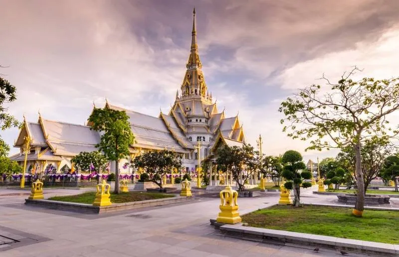
Wat Sothonwararam Worawihan, Chachoengsao Province
Chon Buri Province lies along the eastern coast of the Gulf of Thailand and features coastal plains, hills, and offshore islands. It plays a major role in Thailand’s tourism industry and economy. Pattaya, Bang Saen Beach, and the nearby islands make Chon Buri an accessible destination from Bangkok. At the same time, Si Racha and Laem Chabang are important for port operations and freight transportation. This range of activities means that a single province contains seaside resorts, industrial cities, fishing communities, and local traditions with a long history.
Looking at Chon Buri on a map reveals a coastline broken into bays and peninsulas, creating different kinds of beaches and marine activity areas. Some are busy urban beaches with numerous restaurants, hotels, and seaside activities; others are coastal fishing villages and working harbors. Offshore, Koh Larn near Pattaya and Koh Sichang near Si Racha have different histories and styles of tourism. Choosing where to visit should therefore depend on both the desired atmosphere and the transportation arrangements for each island.
A particularly popular marine attraction is Koh Larn, an island off the coast of Pattaya with several well-known beaches, including Tawaen Beach and Tien Beach. Visitors can relax by the sea, admire the scenery, or enjoy suitable water activities at designated service points. Getting to the island requires a boat from Pattaya. Koh Larn has communities, piers, and beaches on different sides of the island, so it is important to check transportation between the arrival pier and the intended beach, as well as safety arrangements for water activities.
Beyond Koh Larn, Chon Buri includes Pattaya, a major tourist center with abundant accommodation, restaurants, and visitor facilities. Bang Saen Beach near Chon Buri town suits shorter trips, while Koh Sichang offers the atmosphere of an older island community and historical sites associated with the Thai royal court. Cultural travelers can visit traditional markets and temples, whereas nature enthusiasts can explore sections of the coast and selected mangrove areas. The distribution of these attractions makes Chon Buri suitable for both day trips and overnight stays.
Chon Buri’s cultural identity is also reflected in its well-known Buffalo Racing Festival, which is closely connected with the province’s agricultural society. Traditional foods, seafood, and khao lam, or sticky rice cooked in bamboo, are also important local specialties and souvenirs. These traditions show that Chon Buri is not only a modern beach destination but also home to communities that maintain ties to farming and fishing. Responsible travelers should respect community spaces and minimize plastic waste on beaches and islands.
Getting There: From Bangkok, travelers can reach Chon Buri and Pattaya via Sukhumvit Road, the motorway, or other main routes. To visit Koh Larn, travel to a passenger pier in the Pattaya area and take a boat according to the published schedule. Bang Saen and Koh Sichang have different routes and, in the case of Koh Sichang, departure piers from those serving Koh Larn. Check the correct pier and boat schedule directly to avoid arriving at the wrong departure point, and monitor sea conditions during the monsoon season.

Koh Larn, Chon Buri Province
Trat Province is situated on Thailand’s far eastern coast and shares a border with Cambodia. It encompasses coastal plains, river mouths, mangrove forests, mountains, and numerous islands in the Gulf of Thailand. The waters around Trat are important for fishing, marine transportation, and nature-based tourism. The province is especially known for islands with different environments, ranging from larger islands with communities and established tourist roads to smaller, quieter islands popular for snorkeling and nature conservation.
A map of Trat shows that Koh Chang, Koh Kood, and Koh Mak are not all close together; instead, they are distributed across the province’s coastal waters and are reached using different piers and transportation arrangements. Understanding the position of each island before booking accommodation is essential, because transfers between islands may depend on particular boat services and schedules that can change with the weather. Geographically, the coast and its mangroves are also important to marine ecosystems and the livelihoods of fishing communities that have relied on resources from the Gulf of Thailand for generations.
A major attraction is Mu Ko Chang National Park, which encompasses Koh Chang and surrounding islands, with landscapes ranging from mountains, forests, and waterfalls to the sea. Koh Chang is a large island with beaches, communities, and winding mountain roads. Visitors can explore White Sand Beach, Klong Prao Beach, or selected community areas according to road conditions and available services. Snorkeling and boating within the national park must always take account of protected-area regulations and current sea conditions.
Trat is also home to Koh Kood, known for its beaches and natural atmosphere, and Koh Mak, which attracts visitors seeking relaxation and community-oriented tourism. Each island has its own character, so travelers should choose according to their preferred activities and available time. On the mainland, visitors can explore Trat town, its trading areas, and certain mangrove landscapes to understand the connections between land-border commerce and maritime trade, while also enjoying the province’s distinctive seafood and local products.
Trat’s history is also connected with relations between Siam and Western powers during the reign of King Rama V, and with the later naval battle off Koh Chang. Memorial sites and educational attractions help visitors appreciate that this eastern coastal region is more than a holiday destination: it has played historical, political, and international trading roles across several periods. A visit to the islands and Trat town can therefore combine natural scenery with rewarding historical perspectives.
Getting There: Travelers can drive from Bangkok through Chon Buri, Rayong, and Chanthaburi to Trat town, then select the pier serving their intended island. For Koh Chang, check the ferry pier and operating timetable. Koh Kood and Koh Mak use different departure points or boat services. Anyone planning to visit several islands should arrange the sequence around actual boat schedules and allow extra time in case weather forces a service to change or stop temporarily.
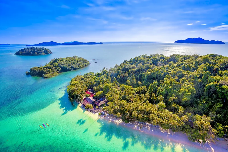
Mu Ko Chang National Park, Trat Province
Prachin Buri Province lies inland in Eastern Thailand. Its geography includes the Prachin Buri River floodplain, agricultural areas, and northern mountain ranges connected with the Dong Phayayen–Khao Yai forests. Although the province has no direct sea coast, it has a significant role in regional river systems, the development of historic settlements, and routes linking the Central Plains with the eastern borderlands. The contrast between plains and forested mountains gives Prachin Buri both traditional riverside urban culture and natural attractions suitable for recreation and ecological learning.
Prachin Buri’s history is closely associated with the ancient town of Si Mahosot, an important settlement during the Dvaravati period. Archaeological remains there reflect the religious and cultural connections of Eastern Thailand in the past. Monuments within the ancient town reveal the development of communities before the emergence of modern urban centers. In subsequent periods, the Prachin Buri River Basin continued to support agriculture and commerce. To understand the province through a map, visitors should therefore consider its ancient sites, present-day town, and more distant upstream forests together.
A particularly interesting architectural and historical landmark is the Chao Phraya Abhaibhubejhr Building, located within Chao Phraya Abhaibhubejhr Hospital in Mueang Prachin Buri District. The historic building has distinctive Western-style architecture and strong associations with the province’s local history. It later came to serve educational purposes related to the history of medicine and Thai medicinal herbs. A visit illustrates the connections between architectural heritage and knowledge of traditional Thai medicine. As building and exhibition areas are subject to visitor regulations established by their managing organization, travelers should check access information beforehand.
Prachin Buri’s leading natural attractions are found around the Dong Phayayen forest ranges, including areas connected with Khao Yai National Park and Thap Lan National Park, which support extensive forests and rich biodiversity. Visitors may choose nature trails, viewpoints, or leisure areas that the responsible agencies have opened to the public. The access routes and regulations of each park should be checked in advance because some locations have seasonal restrictions, visitor controls, or road conditions that differ considerably from those in Prachin Buri town.
Another distinctive feature is the way the province presents its knowledge of medicinal herbs and health-related products through educational sites and community activities. This gives Prachin Buri a tourism identity unlike that of the seaside provinces. Local foods and agricultural produce also reflect the ecology of its river basin. History enthusiasts should allow time for both Si Mahosot and the Chao Phraya Abhaibhubejhr Building, while nature lovers may prefer a separate journey to a national park rather than rushing between distant districts in one day.
Getting There: From Bangkok, travelers can use roads linking Chachoengsao and Prachin Buri or Highway 304, depending on their starting point and destination. Those visiting the Chao Phraya Abhaibhubejhr Building should first head toward central Prachin Buri. The ancient town of Si Mahosot lies in a different area and requires a separately planned route. Visitors traveling to national parks must confirm which entrances are actually open, since these protected areas are extensive and their tourist sites are not necessarily connected by a single road.

Chao Phraya Abhaibhubejhr Building, Prachin Buri Province
Rayong Province lies east of Chon Buri, with a coastline continuing toward Chanthaburi. Its landscape comprises coastal plains, hills, estuaries, and offshore islands. Rayong is known for fruit orchards, industrial activities, seafood, and seaside recreation, giving it a more diverse identity than that of a beach resort alone. On a map of Eastern Thailand, Rayong provides a key link along the route from Chon Buri to Chanthaburi and Trat, while also forming an important part of the eastern seaboard economy.
Rayong’s natural environment is varied, stretching from beaches and islands to fruit orchards and mangrove forests around certain river mouths. Fishing areas and coastal communities reflect longstanding relationships with the Gulf of Thailand, while orchards contribute to the local economy and food culture. Seasonal fruits such as durian, mangosteen, and rambutan are widely enjoyed in Eastern Thailand, but orchard visitors should check harvest periods and individual operators’ arrangements before traveling. Fruit should not be assumed to be available for viewing or picking throughout the year.
One of Rayong’s best-known attractions is Hat Sai Kaew (Koh Samet), on Koh Samet in Phe Subdistrict, Mueang Rayong District. The beach is popular for its sand and seaside leisure activities. Koh Samet is associated with Khao Laem Ya–Mu Ko Samet National Park, so the destination includes tourist facilities alongside rules for protecting natural resources. Visitors should check national park regulations and the guidance of service operators before undertaking activities, especially water sports and journeys to bays far from the island’s principal pier.
Rayong also offers Laem Mae Phim, a coastal area with restaurants and places for visitors to relax, and Thung Prong Thong near the Prasae estuary, where a nature trail introduces mangrove ecosystems and the distinctive landscape of the prong trees. The province also has sites associated with Sunthorn Phu, an important Thai poet, and historic communities with their own seafood traditions. Visitors can therefore combine beaches, islands, natural attractions, and literary history, using Rayong as a base before continuing to Chanthaburi.
In transportation and economic terms, Rayong contains major industrial areas and ports along the eastern seaboard. Large-scale economic development exists alongside agricultural areas and fishing villages in several districts, so the province’s roles in both production and tourism deserve attention. When planning routes, travelers should account for traffic around industrial towns and on access roads to popular beaches, which may become busy on weekends and public holidays.
Getting There: Travelers can use Sukhumvit Road or other main highways connecting Chon Buri with Rayong. To reach Koh Samet, head for the Ban Phe area and choose a pier offering services to the island according to its announced schedule; this should not be confused with the departure piers for Koh Larn in Chon Buri. Laem Mae Phim and the Prasae estuary require continued travel east within Rayong. Visitors with limited time may prefer to focus either on Koh Samet or on mainland coastal attractions, allowing enough time to enjoy each location.

Hat Sai Kaew (Koh Samet), Rayong Province
Sa Kaeo Province lies in eastern Thailand and shares a land border with Cambodia. It is an inland province without a direct sea coast. Its landscape includes plains, farmland, forests, mountain ranges, and border areas important to commerce and transportation. Geographically, Sa Kaeo is a gateway connecting routes from Central and Eastern Thailand with a neighboring country. At the same time, its ancient archaeological heritage and natural attractions make it an interesting choice for visitors wishing to explore Eastern Thailand beyond the beaches.
For centuries, Sa Kaeo has been connected to overland transportation routes between settlements in what is now Thailand and communities on the Cambodian side of the border. Today, Aranyaprathet District is an important economic and border-trading area. Rong Kluea Market is one of its best-known destinations and reflects the importance of cross-border merchandise trading. Visitors should be aware of rules and current conditions in the border area, since access and certain commercial activities may be subject to requirements different from those at ordinary tourist markets.
A particularly notable archaeological monument is Sdok Kok Thom Sanctuary, located in Khok Sung District. This ancient stone sanctuary, associated with Khmer cultural influence, is historically and archaeologically significant. Its layout includes religious structures, pathways, and features related to moats and enclosure walls, reflecting ideas about sacred space in the ancient community. The site is also famous for an inscription that provides important evidence for studying the history of the Khmer Empire. Exploring the sanctuary is especially rewarding for those interested in sandstone architecture and the religious traditions of Southeast Asia.
In addition to Sdok Kok Thom, Sa Kaeo has striking geomorphological attractions such as Lalu, where erosion has created earthen pillars and walls of unusual shapes, as well as forests and natural areas connected with the border mountain ranges. These attractions differ considerably from the stone sanctuary and border market, making Sa Kaeo a destination that can be explored according to particular interests, whether ancient history, geology, community life, or landscape photography.
A provincial map also shows the separation between Sa Kaeo town, Aranyaprathet District, and Khok Sung District, which occupy different parts of the province and should not be treated as a single compact sightseeing area. Visitors hoping to combine stone monuments with the border market may need to travel along secondary roads and allow suitable time for breaks. Road conditions during the rainy season and announcements about access to tourist sites should also be checked with the responsible agencies.
Getting There: From Bangkok, take Highway 33 and suitable connecting highways toward the intended destination in Sa Kaeo. For Rong Kluea Market, continue toward Aranyaprathet District; Sdok Kok Thom Sanctuary lies in Khok Sung District and requires a different route from the border market. Travelers should check actual road distances using a map application before departure. Anyone intending to cross the international border should consult official information on checkpoint procedures and required documents directly.

Sdok Kok Thom Sanctuary, Sa Kaeo Province
Examining all seven provinces on the map reveals that Eastern Thailand includes both coastal provinces and inland provinces with forests, mountains, or borderlands. Chachoengsao stands out for its river basin and religious heritage. Chon Buri and Rayong play major roles in beach tourism, islands, and economic activity. Chanthaburi combines a historic town, fruit orchards, and natural attractions. Trat is distinguished by its many islands and coastal ecosystems, while Prachin Buri and Sa Kaeo are important for archaeological history and inland transportation routes. Grouping the provinces in this way enables more precise travel choices than treating all of Eastern Thailand as a single beach destination.
Travel Routes through Eastern Thailand Based on the Map can be organized in several ways. Visitors with limited time who enjoy temples or historic communities can make Chachoengsao their main destination and add nearby areas if time permits. Those seeking a relaxing coastal holiday can follow the Chon Buri–Rayong route, allowing a separate day for Koh Larn or Koh Samet rather than attempting several boat transfers in one day. Travelers interested in fruit orchards, historic towns, and quieter coastal scenery can plan a multi-day Rayong–Chanthaburi–Trat itinerary. Those drawn to ancient history should consider Prachin Buri–Sa Kaeo, mapping the archaeological sites according to their actual locations.
Eastern Thailand’s traditions and cultural life reflect the diversity of Thai, Chinese, Vietnamese, and other ethnic communities that have settled in the region over many generations. Cultural tourism should therefore respect the context of each community, whether paying respects to Luang Pho Sothon in Chachoengsao, exploring Chanthaboon Riverside Community, studying ancient settlements in Prachin Buri and Sa Kaeo, or learning about fishing-village life along the Gulf of Thailand. Seafood, seasonal fruits, and local products are all part of the region’s distinctive tourism identity and can be appreciated alongside each province’s history.
When to Visit Eastern Thailand depends on the activities planned and current weather conditions. Historic towns and religious landmarks can be explored throughout the year, preferably avoiding the hottest parts of the day. Island trips and marine activities require particular attention to sea forecasts and boat schedules: strong offshore winds can occur even when rainfall on land is not heavy. Orchard visitors should verify harvest seasons with operators directly. Those heading into forests, mountains, and waterfalls should follow protected-area announcements to reduce risks from flash floods or seasonal trail closures.
For responsible travel, avoid leaving litter in the sea or waterways, do not remove coral or wildlife from natural habitats, respect national park and community rules, and dress appropriately when visiting places of worship. Using locally operated services and purchasing suitable local products can also help distribute tourism income within communities. Learning about a destination’s history and geography before visiting makes it easier to appreciate its significance beyond photographing well-known viewpoints.
Summary: The map of Eastern Thailand covers seven provinces: Chanthaburi, Chachoengsao, Chon Buri, Trat, Prachin Buri, Rayong, and Sa Kaeo. Each has distinct geographical, historical, economic, and tourism characteristics. Using a map together with a provincial summary table helps visitors identify locations and plan clear, practical routes. Depending on their interests, travelers can explore beaches, islands, historic temples, riverside communities, mountains, forests, and archaeological monuments, while checking current transportation information and the status of attractions with the relevant authorities before departure.
Frequently Asked Questions (FAQ)
Q: How many provinces are in Eastern Thailand?
A: Under the geographical regional classification, Eastern Thailand has seven provinces: Chanthaburi, Chachoengsao, Chon Buri, Trat, Prachin Buri, Rayong, and Sa Kaeo.
Q: Why do some maps of Eastern Thailand show eight provinces?
A: Different agencies use different regional classifications. For example, the Thai Meteorological Department includes Nakhon Nayok in Eastern Thailand, whereas the geographical classification used in this article counts seven provinces.
Q: Which provinces in Eastern Thailand have coastlines?
A: Five provinces border the Gulf of Thailand: Chachoengsao, Chon Buri, Rayong, Chanthaburi, and Trat. Chachoengsao meets the Gulf at the Bang Pakong estuary, while Prachin Buri and Sa Kaeo have no sea coast.
Q: Which Eastern Thailand provinces are landlocked?
A: Prachin Buri and Sa Kaeo are inland provinces known for river basins, forests, mountains, historical landmarks, and border areas.
Q: What are some popular beach and island destinations in Eastern Thailand?
A: Major destinations include Koh Larn and Bang Saen Beach in Chon Buri, Koh Samet in Rayong, and Koh Chang, Koh Kood, and Koh Mak in Trat.
Q: What historical attractions are worth visiting in Eastern Thailand?
A: Examples include Wat Sothonwararam Worawihan in Chachoengsao, Chanthaboon Riverside Community in Chanthaburi, the Chao Phraya Abhaibhubejhr Building and ancient town of Si Mahosot in Prachin Buri, and Sdok Kok Thom Sanctuary in Sa Kaeo.
Q: How can a map of Eastern Thailand help with travel planning?
A: It shows neighboring provinces, coastlines, islands, and inland areas, helping travelers choose connected routes, minimize backtracking, and distinguish journeys requiring boats from mainland road trips.
Q: Which provinces are good for short trips from Bangkok?
A: Chachoengsao and Chon Buri are popular choices for short trips. Rayong may be better suited to an overnight stay when visiting Koh Samet or several attractions.
Q: Where should I go to explore historic towns and riverside communities?
A: Consider Chanthaboon Riverside Community in Chanthaburi and Ban Mai 100-Year Market in Chachoengsao. The Chao Phraya Abhaibhubejhr Building in Prachin Buri is another interesting choice for historic architecture.
Q: Can I take boats to Koh Larn, Koh Samet, and Koh Chang from the same pier?
A: No. Koh Larn is in Chon Buri, Koh Samet is in Rayong, and Koh Chang is in Trat. Each island has its own departure points and schedules, so travelers should verify the correct pier before leaving.
Q: What is the best time of year to visit Eastern Thailand?
A: Choose according to the intended activities and current weather forecast. Marine trips depend on wind and wave conditions and boat schedules; orchard visits depend on harvest seasons; and national parks and waterfalls may have access restrictions announced by the managing agencies.
Q: Where can I see an important Khmer archaeological site in Eastern Thailand?
A: Sdok Kok Thom Sanctuary in Khok Sung District, Sa Kaeo Province, is an important archaeological site known for its stone architecture and ancient inscriptions.
 Category: ●Travel Articles, Recipes
 Group: ●Travel Review, Food Review
Last Update : 1 DayAgo
 Last Update : 1 DayAgo
Recommend

 Art, Culture and Heritage
 Historical Sites and Monuments(7)
 Landmarks and Memorials(7)
 Royal Palace(1)
 Art, Craft Centres, Tradition(7)
 Museums(2)
 Educational Places
 Educational Gardens, Farm(5)
 University
 Autonomous Universities(1)
 Rajamangala University of Technology(1)
 Rajabhat University(1)
 Places of Worship
 Temple(25)
 Church(1)
 Other Sacred Sites(16)
 Research and Development
 Royal Project(1)
 Suburban Living
 Village, Community(4)
 Local Market(5)
 Nature and Wildlife
 National Parks and Marine Reserves(7)
 Mountain (Doi)(3)
 Dam, Reservoir, Lake(8)
 Waterfalls(21)
 Hot Springs(1)
 Caves(4)
 River, Canal(3)
 Bays and Beaches(9)
 Islands(2)
 Other natural attractions(3)
 Entertainment and Agricultural
 Zoos and Aquariums(3)
 Stadium(1)
 Farms, Parks and Ecotourism(7)
 Outdoor and Adventure Activities(3)
Travel Review, Food Review(4)


