
lovethailand home >Northeastern Travel Attractions >Ubon Ratchathani Travel Attractions >Pho Sai >Song Khon > Kaeng Song Khon (Sam Phan Bok)
TL;DR: Kaeng Song Khon (Sam Phan Bok) is located at Ban Song Khon area, Pho Sai District, Ubon Ratchathani Province, open Daily, hours 00:00 – 23:59.
Kaeng Song Khon (Sam Phan Bok)
Open Days: Daily
Opening Hours: 00:00 – 23:59
Admission Fees: No admission fee
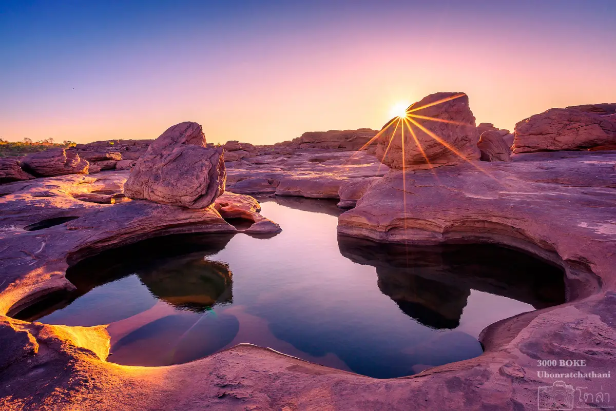
Kaeng Song Khon, also widely known as Sam Phan Bok in Ubon Ratchathani, is one of the most remarkable natural attractions along the Mekong River in Pho Sai District, Ubon Ratchathani Province. Located around Ban Song Khon, this vast sandstone riverbed is famous for thousands of naturally carved rock basins, giving rise to the name “Sam Phan Bok,” or “Three Thousand Rock Basins.” When the Mekong River rises during the rainy season, much of the rock field remains hidden beneath the current. When the water level drops in the dry season, the sandstone formations emerge and reveal an extraordinary landscape of holes, pools, grooves, cliffs, and sculpted rock surfaces. This dramatic seasonal transformation has made Sam Phan Bok known as the “Grand Canyon of the Mekong.”
Sam Phan Bok is not only a scenic viewpoint for photography. It is a place where geology, river ecology, local legend, and community life meet in one landscape. The word “bok” is a Lao and local Mekong term meaning a basin, hollow, or deep water hole in a rock bed. Because the sandstone surface contains more than 3,000 such basins, local people call the area Sam Phan Bok. The name is simple, descriptive, and deeply connected to the language and life of communities along the Mekong River. For visitors, the site offers a rare opportunity to walk on an exposed riverbed and see how water can slowly carve solid stone into graceful natural forms.
The formation of Sam Phan Bok is the result of long-term erosion by the Mekong River. During the high-water season, strong currents flow over the sandstone bed. Sand, gravel, and small stones are carried by the current and trapped in cracks or lower points on the rock surface. As the water swirls repeatedly in the same spots, these materials gradually grind the stone. Over time, small depressions grow wider and deeper. This process creates circular, oval, and irregular basins of many different sizes. Some are small enough to be compared with stone cups, while others are large and deep enough to resemble natural pools. This is why the surface of Sam Phan Bok looks like a vast natural sculpture shaped by water, stone, and time.
The best season to see Sam Phan Bok clearly is from December to May, when the Mekong River level is low and the rock formations are exposed. During this period, visitors can walk across the stone terrace, observe the basins closely, and take photographs of the unusual formations. In the rainy season and during high water, many parts of the rock field are submerged. The destination is therefore strongly seasonal. Travelers who want to see the full landscape of the “Grand Canyon of the Mekong” should plan their trip during the dry season, especially in the morning or late afternoon when the light is soft and the temperature is more comfortable.
The appeal of Sam Phan Bok lies in the variety of shapes created by natural erosion. Some basins look nearly circular, some are oval, some resemble stars, some appear like hearts, and many encourage visitors to use their imagination. One of the best-known features is the dog-head-shaped rock near the entrance. This rock is connected with local legends. One story tells of a powerful ruler who was impressed by the beauty of Sam Phan Bok and sent his officers to explore the area. When treasure was discovered, the ruler ordered a faithful dog to guard the entrance. Driven by greed, the ruler left by another route, and the loyal dog waited until it died and turned into stone. Another version says that a child of the Naga in the Mekong created a new waterway and assigned a dog to guard the entrance until the dog eventually died and became the rock seen today.
These legends give Sam Phan Bok cultural depth beyond its physical beauty. Visitors do not see only unusual rocks; they also encounter local stories about loyalty, greed, treasure, and the Naga, a powerful symbol in Mekong beliefs. The dog-head rock shows how communities interpret natural forms through memory and imagination. As a result, walking through Sam Phan Bok becomes both a visual journey and a cultural reading of the river landscape.
In several areas, the eroded rock field resembles a small canyon landscape. Sandstone has been carved into grooves, channels, low walls, and basin clusters that create a rugged and dramatic scene. This is why villagers and travelers often call the place the Grand Canyon of the Mekong. Although its scale and setting differ from the Grand Canyon in the United States, the feeling of standing on a broad rock field beside a major river, surrounded by sculpted stone surfaces and deep hollows, is powerful and memorable. Sam Phan Bok has its own identity: a Mekong landscape of rock, water, sand, wind, light, and local life.
The Sam Phan Bok area is closely connected with Ban Song Khon and Hat Salueng. Hat Salueng is a long, fine white sand beach along the Mekong River and serves as an important boat departure point for travelers who want to explore Sam Phan Bok and nearby river attractions. A boat trip provides a wider view than walking on the rock field alone. Along the route, travelers can see riverbanks, rock formations, changing currents, local communities, Pak Bong, and Hin Hua Phaniang. This makes it clear that Sam Phan Bok is not an isolated attraction but part of a larger Mekong landscape made up of beaches, rapids, narrow river channels, fishing communities, and seasonal natural formations.
Pak Bong is another important stop near Sam Phan Bok. It is known as one of the narrowest points of the Mekong River in this region, with the river only about 56 meters wide. At this point, the water is compressed through a narrow passage, creating a powerful visual impression. Unlike wider stretches of the Mekong, Pak Bong allows visitors to see the force of the river more clearly. It is also linked with local fishing knowledge, as villagers read the current, seasons, and fish behavior through long experience.
Just north of Pak Bong is Hin Hua Phaniang, a large rock formation that stands across the Mekong and divides the river into 2 streams. In the local language, “song khon” refers to this splitting of the current, which is connected to the name Ban Song Khon. Hin Hua Phaniang shows how the geography of the Mekong has shaped local place names and community identity. A rock in the river is not only a natural obstacle; it can become a fishing marker, a navigation point, a cultural reference, and part of the origin story of a village.
The Ban Song Khon and Pho Sai area also has river-based traditions, especially the local fish-catching competition that takes place around February. This tradition reflects old fishing knowledge along the Mekong. It depends on skill, timing, water level, and knowledge of fish movement rather than modern industrial fishing methods. For local communities, the Mekong is not just a river. It is a source of food, a seasonal calendar, a place of work, and a living cultural space.
Hat Hong is another recommended stop on a Sam Phan Bok route. It was formed by sand and sediment carried and deposited by the Mekong River, creating a broad sandy area that resembles a small desert. Because of this appearance, it is often called a mini Sahara or a mini Mui Ne. The best time to visit Hat Hong is in the late afternoon, when warm sunlight falls across the sand and creates a golden glow. For photographers, Hat Hong makes an excellent sunset location and a beautiful ending to a Mekong river trip.
Hat Hin Si, also known as the colored stone area, adds another layer to the Mekong landscape. It is a wide rock field mixed with patches of sand. Many stones have smooth, polished surfaces and display colors such as yellow, grey, green, purple, orange, and blue, depending on mineral content, surface condition, and water polishing. This area expands the travel experience beyond the basins of Sam Phan Bok and shows that the Mekong has shaped many different types of stone surfaces along the same route.
Lak Sila Lek is a historical marker located before Hat Hong. It was made by the French to indicate Mekong water levels for safer navigation during the period when France controlled Laos. This gives the Sam Phan Bok route a historical dimension. The Mekong River has long been a natural attraction, a transportation route, an economic corridor, and a space connected with regional history. For travelers interested in more than scenery, Lak Sila Lek helps connect the river landscape with the history of river navigation and cross-border relationships in the Mekong basin.
Visitors should prepare properly before walking around Sam Phan Bok. The rock field contains smooth surfaces, rough sections, grooves, water basins, and uneven levels. Good walking shoes are important. During the dry season, the stone can become very hot in the middle of the day, so travelers should bring drinking water, a hat, sunglasses, and comfortable clothing. Those visiting at sunrise or after sunset should carry a flashlight. Wet areas and rock surfaces with algae can be slippery, especially near deep holes, so walking carefully is essential.
The most pleasant times to visit Sam Phan Bok are early morning and late afternoon. Morning light is soft and often gives beautiful reflections in the water-filled basins. Late afternoon light creates depth in the grooves and highlights the texture of the sandstone. Photographers often prefer sunrise or sunset because angled light makes the rock forms more dramatic than harsh midday sun. Travelers who want to take a boat trip should coordinate their timing with local boat services and the river level.
The main zones of Sam Phan Bok include the rock basin field, large basin viewpoints, the dog-head rock, the walking access route, the Hat Salueng boat area, the river route toward Pak Bong, Hin Hua Phaniang, Hat Song Khon, Hat Hong, Hat Hin Si, and Lak Sila Lek. Each zone has its own character. The main rock field is best for walking and close-up photography. Hat Salueng is useful for boat access and beach scenery. Pak Bong shows the narrow power of the Mekong. Hat Hong is best for sunset light. Lak Sila Lek is suitable for travelers interested in historical river navigation.
Getting There from Ubon Ratchathani city is straightforward by private car or rental car. Take Highway 2050 through Trakan Phuet Phon District toward Pho Sai District. The distance from Ubon Ratchathani city is about 120 km. From Pho Sai, continue toward Ban Song Khon and the Sam Phan Bok area for about 3 km. This route is more convenient with private transport because it allows better control of time, especially for sunrise, sunset, and boat trips. Travelers who want an easier trip can stay overnight in Pho Sai, Song Khon, or Khemarat.
Travelers using public transport can reach Pho Sai or nearby areas and then arrange local transport to Ban Song Khon or Hat Salueng. Boat trips to Sam Phan Bok and nearby Mekong attractions commonly start from Hat Salueng. Choosing local operators who understand the water level, channels, and safe landing points is important because the Mekong changes by season. A local boatman or guide helps visitors see more places and travel more safely.
There is no admission fee to visit Sam Phan Bok. However, optional services such as boat rides, local transport, parking, or community guiding services are charged separately depending on the service chosen on site. Some areas can be explored on foot, while boat trips allow travelers to see Pak Bong, Hin Hua Phaniang, Hat Hong, Hat Hin Si, and the wider Mekong landscape from the water. Travelers should choose the experience that fits their schedule, fitness level, and preferred travel style.
Responsible travel is important at Sam Phan Bok. Visitors should not throw rubbish into the rock basins, write or scratch on the rocks, remove stones or natural materials, jump into deep holes, climb risky sections, or go near strong currents without local guidance. The basins and grooves took a long time to form. Keeping them clean and undamaged protects the site for future travelers and for the local community that depends on sustainable tourism.
For families with children, Sam Phan Bok is an excellent outdoor learning site. Children can see real examples of erosion, rock basin formation, changing water levels, and the role of the Mekong River in shaping landforms and community life. Parents can explain how swirling water, sand, and gravel carve stone into hollows. They can also show why the site disappears under water during the rainy season and becomes visible during the dry season. Adults should supervise children closely because the rock field contains deep holes and uneven surfaces.
For in-depth travelers, Sam Phan Bok should be understood as a geological, cultural, and community landscape rather than only a photo spot. The landform was created by the Mekong, one of Southeast Asia’s great rivers. The dog-head rock and Naga stories reflect Mekong beliefs. Local fishing traditions show practical river knowledge. Lak Sila Lek reflects navigation history. Together, these elements make Sam Phan Bok a place of many layers: stone, water, time, people, legends, and memory.
Restaurants near Sam Phan Bok include local riverside restaurants, Thai and Isan food shops, cafés, and resort restaurants in Pho Sai. Travelers can plan meals before or after walking down to the rock field. Mekong fish dishes, local Isan food, and simple à la carte meals are practical choices for families and groups. Accommodation options include small resorts and guesthouses near Pho Sai and Ban Song Khon, as well as hotels and riverside stays in Khemarat for those who want to combine Sam Phan Bok with the old town and Mekong walking routes.
A full-day itinerary can begin with Sam Phan Bok in the morning or late afternoon, followed by Hat Salueng, Pak Bong, Hin Hua Phaniang, Hat Hong, and Hat Hin Si. With more time, travelers can add the 100-year-old rain tree in Pho Sai or continue to Khemarat for walking street culture and riverside atmosphere. This route reveals northern Ubon Ratchathani through nature, river scenery, rock formations, sandbars, communities, food, and local traditions.
In conclusion, Kaeng Song Khon or Sam Phan Bok is one of Ubon Ratchathani’s most valuable natural attractions. Its sandstone riverbed was carved by swirling Mekong currents during the high-water season, creating more than 3,000 basins and unusual rock forms. The dry season from December to May is the best time to see the landscape. Visitors can explore rock basins, local legends, sand beaches, narrow river channels, fishing culture, and nearby Mekong attractions in one journey. Sam Phan Bok is suitable for Thai travelers, foreign visitors, photographers, families, and anyone who wants to understand the Mekong River in a deeper and more memorable way.
| Name | Kaeng Song Khon / Sam Phan Bok |
| Other Names | Kaeng Sam Phan Bok, Grand Canyon of the Mekong |
| Location | Ban Song Khon area, Pho Sai District, Ubon Ratchathani Province |
| Address | Song Khon Subdistrict, Pho Sai District, Ubon Ratchathani 34340, Thailand |
| Highlights | A large sandstone riverbed in the Mekong River with more than 3,000 natural rock basins, clearly visible during the dry season and widely known as the Grand Canyon of the Mekong |
| History / Formation | Formed by long-term erosion from Mekong currents during the high-water season, creating basins, grooves, channels, and unusual sandstone forms |
| Name Origin | The word “bok” means a basin or deep water hollow in a rock bed. Sam Phan Bok refers to the thousands of rock basins found across the sandstone riverbed. |
| Distinctive Features | Round, oval, and naturally shaped rock basins, dog-head rock, deep grooves, broad sandstone terraces, and Mekong River scenery |
| Best Travel Period | December – May, especially early morning and late afternoon for walking, photography, and boat trips |
| Travel Information | From Ubon Ratchathani city, take Highway 2050 through Trakan Phuet Phon District toward Pho Sai District, about 120 km, then continue to Ban Song Khon and the Sam Phan Bok area for about 3 km. |
| Current Status | Open to visitors as a natural Mekong River attraction in Pho Sai District |
| Open Days | Daily |
| Opening Hours | 00:00 – 23:59 |
| Fees | No admission fee. Boat rides, local transfers, parking, or community tour services are charged separately depending on the selected service. |
| Facilities | Parking area, Hat Salueng boat point, local restaurants, viewpoints, photo areas, and seasonal community tour services |
| Main Areas / Zones | Sam Phan Bok rock field, more than 3,000 rock basins, dog-head rock, access route to the rapids, Hat Salueng, Pak Bong, Hin Hua Phaniang, Hat Song Khon, Lak Sila Lek, Hat Hong, and Hat Hin Si |
| Caretaker | Song Khon Subdistrict Administrative Organization, Pho Sai District, Ubon Ratchathani Province, and Ban Song Khon tourism community |
| Main Contact Number | Song Khon Subdistrict Administrative Organization Tel. 045-251-891 / Sam Phan Bok vehicle and boat coordinator Tel. 094-383-8997 |
| Official Website / Official Page | Song Khon Subdistrict Administrative Organization, Pho Sai District, Ubon Ratchathani Province |
| Nearby Tourist Attractions | 1. Hat Hong, about 1 km 2. Hat Salueng Ubon, about 3 km 3. 100-Year-Old Rain Tree, Pho Sai, about 3 km 4. Hat Hin Si, about 5 km 5. Pak Bong, the narrowest Mekong point, about 4 km 6. Hin Hua Phaniang, about 4 km 7. Lak Sila Lek, about 6 km 8. Hat Hae, about 7 km |
| Nearby Restaurants | 1. Khrua Rabiang Khong, about 1 km 2. Khrua Sam Phan Bok, about 4 km, Tel. 085-026-6295, 087-242-3601 3. Khrua Song Khon Resort, about 3 km 4. Jungle Cafe Pho Sai Ubon Ratchathani, about 15 km, Tel. 099-118-2537 5. Phosai Coops and Farm, about 15 km, Tel. 080-929-8788 6. Khrua Chom Dao at Plaifah Resort Ubon, about 9 km, Tel. 085-495-2373 |
| Nearby Accommodations | 1. Baan Suan Natchana, about 4 km 2. Plaifah Resort Ubon, about 9 km, Tel. 085-495-2373 3. Song Khon Resort, about 3 km 4. The Goose Farm Stay, about 17 km 5. The Khong @ Khemarat, about 33 km, Tel. 063-038-9888, 080-010-8999 6. Laekhong River Resort, about 32 km, Tel. 087-111-2836 7. Pha Taem & Kaeng Phisamai Riverside, about 46 km, Tel. 093-321-9889 |
Frequently Asked Questions (FAQ)
Q: Where is Kaeng Song Khon or Sam Phan Bok located?
A: Kaeng Song Khon or Sam Phan Bok is located around Ban Song Khon in Pho Sai District, Ubon Ratchathani Province. It is a natural Mekong River attraction known for its vast sandstone rock field and thousands of basins.
Q: What are the opening days and hours of Sam Phan Bok?
A: Sam Phan Bok is open daily from 00:00 to 23:59. The most suitable visiting times are early morning and late afternoon.
Q: Is there an admission fee for Sam Phan Bok?
A: There is no admission fee. Optional services such as boat rides, local transfers, parking, or community guiding services are charged separately.
Q: What is the best month to visit Sam Phan Bok?
A: December to May is the best period because the Mekong River level drops and the sandstone formations become clearly visible.
Q: What does the word “bok” mean in Sam Phan Bok?
A: “Bok” means a basin or deep water hollow in a rock bed. Sam Phan Bok refers to the thousands of natural basins across the sandstone riverbed.
Q: How was Sam Phan Bok formed?
A: Sam Phan Bok was formed by long-term erosion from Mekong currents. Swirling water, sand, gravel, and small stones gradually carved the sandstone into basins, grooves, and unusual rock shapes.
Q: What nearby places can travelers visit after Sam Phan Bok?
A: Nearby places include Hat Salueng, Pak Bong, Hin Hua Phaniang, Hat Hong, Hat Hin Si, Lak Sila Lek, and the 100-year-old rain tree in Pho Sai.
Q: What should visitors prepare before going to Sam Phan Bok?
A: Visitors should wear shoes with good grip, bring drinking water, a hat, sunglasses, and comfortable clothing because the area is a natural rock field with deep holes, grooves, and uneven surfaces.
 Category: ●Nature and Wildlife
 Group: ●Other natural attractions
Last Update : 2 MonthAgo
 Last Update : 2 MonthAgo
 Click to Access the Navigation Map GPS
Kaeng Song Khon (Sam Phan Bok) Map
Gellery
Recommend

 Art, Culture and Heritage
 Historical Sites and Monuments(5)
 Landmarks and Memorials(2)
 Royal Palace(1)
 Art, Craft Centres, Tradition(7)
 Museums(3)
 Places of Worship
 Temple(37)
 Other Sacred Sites(4)
 Research and Development
 Royal Project(2)
 Suburban Living
 Village, Community(2)
 Local Market(4)
 National Parks and Marine Reserves(5)
 Mountain (Doi)(6)
 Dam, Reservoir, Lake(8)
 Waterfalls(12)
 Hot Springs(1)
 Caves(2)
 River, Canal(11)
 Bays and Beaches(8)
 Islands(2)
Other natural attractions(6)
Islands(2)
Other natural attractions(6)
 Entertainment and Agricultural
 Zoos and Aquariums(1)
 Animal camps and shows(1)
 Farms, Parks and Ecotourism(1)


