
lovethailand home >Northeastern Travel Attractions >Si Sa Ket Travel Attractions >Kan Thora Rak >Sao Thong Chai > Khao Phra Wihan National Park
TL;DR: Khao Phra Wihan National Park, Si Sa Ket attractions : Nature and Wildlife, National Parks and Marine Reserves.
Khao Phra Wihan National Park
Open Days: Temporarily Closed For Tourism Since 29 May 2025 Until Further Notice From Khao Phra Wihan National Park
Regular Opening Hours When Open: 06.00 - 18.00
Khao Phra Wihan National Park, Si Sa Ket, is located in the Khao Phra Wihan National Reserved Forest along the Phanom Dong Rak mountain range on the Thailand-Cambodia border. The park covers Kantharalak District in Si Sa Ket Province and Nam Khun and Nam Yuen districts in Ubon Ratchathani Province. It was declared Thailand’s 83rd national park on 20 March 1998 and covers about 130 square kilometers, or 81,250 rai. The landscape includes sandstone cliffs, rocky plateaus, ridges, dry evergreen forest, mixed deciduous forest, and dry dipterocarp forest. Khao Phra Wihan National Park is one of the most important natural, historical, archaeological, and borderland destinations in Lower Isan.
The latest tourism status of the park is a temporary closure of its main visitor areas, especially Pha Mo I Daeng and other sites close to the border. The closure is a safety measure related to the Thailand-Cambodia border situation. This is not a permanent closure of the national park, but a temporary tourism restriction. The article therefore presents the park as an important Si Sa Ket destination while clearly identifying its current status, so that visitors understand both the value of the place and the travel limitation in effect during the closure period.
The name “Khao Phra Wihan” is directly associated with Preah Vihear Temple, an important ancient Khmer sanctuary located on the high ridge on the Cambodian side. On the Thai side, the most famous visitor area is Pha Mo I Daeng, a cliff viewpoint within Khao Phra Wihan National Park. From this viewpoint, visitors can see the borderland forest and, on clear days, the area of Preah Vihear Temple from a distance. This makes the park a place where nature, ancient history, and regional geography come together in a striking way.
The park’s landscape is shaped by the Phanom Dong Rak mountain range, a natural barrier between the Isan plateau of Thailand and the Cambodian plain. The Thai side slopes down toward Si Sa Ket, while the cliff edge creates dramatic views over the lower land. Sandstone rock surfaces and reddish cliff faces give Pha Mo I Daeng its distinctive appearance. In the morning and late afternoon, light on the sandstone makes the cliff especially vivid. This geological and visual character is one reason the area has become strongly associated with Si Sa Ket tourism.
The park contains several forest types, including dry evergreen forest, mixed deciduous forest, and dry dipterocarp forest. Each forest type supports different plants and wildlife. The forests along the border are home to wild boar, deer, barking deer, rabbits, squirrels, gibbons, civets, and many smaller animals. Since the area is connected with broader borderland forest, wildlife can move through natural habitats across the mountain range. The park is therefore valuable not only for scenery but also for biodiversity and watershed conservation.
The main highlight of the park is Pha Mo I Daeng, a red sandstone cliff viewpoint behind the visitor center. When the park is open, visitors usually come here to watch sunrise, see the sea of mist, and enjoy the wide panorama of the Thailand-Cambodia borderland. During the late rainy season and early cool season, mist often rises over the forest below, creating one of the most memorable views in northeastern Thailand. Pha Mo I Daeng is therefore a symbolic viewpoint of Si Sa Ket and one of the most recognized border viewpoints in Isan.
Pha Mo I Daeng also has historical importance because it allows visitors to understand the position of Preah Vihear Temple in relation to the ridge and the surrounding landscape. Although the temple itself is on the Cambodian side and direct access from Thailand is not normally available, the viewpoint shows how the sanctuary was placed on a high cliff overlooking the plain. This helps visitors understand why the mountain ridge was significant in ancient Khmer sacred geography and why this borderland has such deep historical importance.
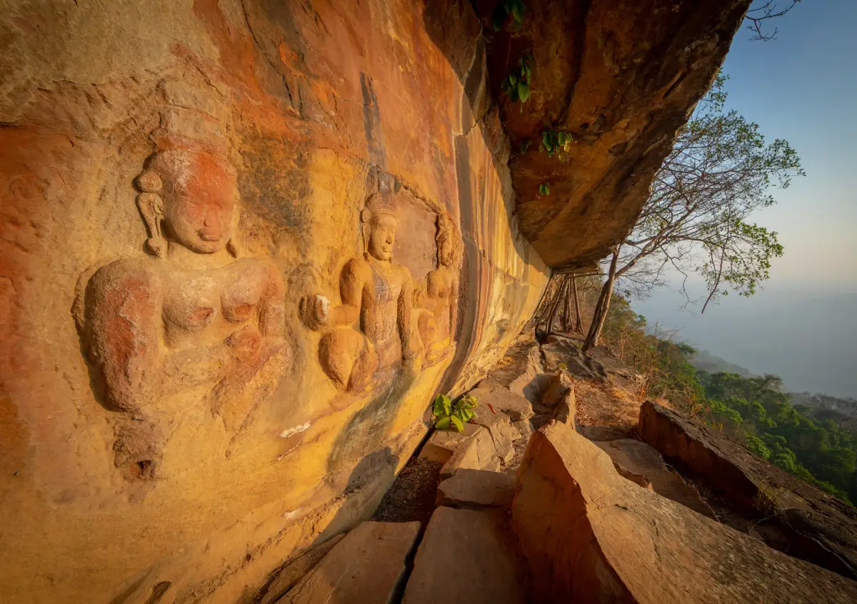
Another important site is the bas-relief carving below Pha Mo I Daeng. When the area is open, visitors can descend by stairs to see the carving on the sandstone cliff face. The relief shows three deity figures and is believed to be more than 1,000 years old. Local interpretation describes it as a practice carving made by Khmer artisans before carving at Preah Vihear Temple. Whether read as practice work or sacred artwork, the relief is clear evidence that the cliff and surrounding rock landscape were connected with Khmer artistic and religious activity.
To the west of Pha Mo I Daeng stands the Twin Stupas, locally called Phra That. These are two sandstone structures with cubic lower forms and rounded upper parts. The interiors are hollow and were used to contain objects. The presence of these twin monuments on the high ridge suggests that the area had symbolic and ritual importance beyond its scenic value. Together with the relief carvings and the view toward Preah Vihear, the Twin Stupas show how the cliff landscape functioned as a sacred cultural space in the past.
Sa Trao, or Huai Trao, is a stream and water area on the stone platform near the base of Khao Phra Wihan. Water flows through a cave-like opening beneath the rock and into a lower area where stone formations guide the flow. Water management was a major part of Khmer sacred architecture and settlement planning, so Sa Trao is often understood in relation to ancient water systems. Today, the area has been restored and cleaned for water retention and park use. It adds an important environmental and archaeological dimension to the park.
Namtok Khun Si and Tham Khun Si are located near the route associated with the old approach toward Preah Vihear. Namtok Khun Si is a three-tier waterfall above Tham Khun Si, while the cave itself is a wide chamber connected with local legend. The story says Khun Si used the cave as a resting place while supervising stone cutting at Sa Trao for the construction of Preah Vihear Temple. This story links natural rock, water, labor, and ancient construction memory into one landscape narrative.
Prasat Don Tuan is another Khmer monument associated with the park’s wider cultural route. It is located near Ban Phumisrol in Bueng Malu Subdistrict, Kantharalak District, and dates to around the 15th-16th Buddhist centuries. The monument is accessible by paved road and has parking facilities when local conditions allow. A local legend tells of Nang Nom Yai, or Neang Dothom, resting at this place while traveling to meet a king. This gives Prasat Don Tuan both archaeological and folkloric value within the Kantharalak borderland.
Huai Khanun Reservoir is an irrigation reservoir and the location of a park protection unit, about 25 kilometers from the park office. The reservoir area offers quiet scenery and is suitable for rest, nature viewing, and camping when the park opens the area for visitor use. It adds a calmer water landscape to a route otherwise known for cliffs, viewpoints, and Khmer ruins. For travelers, it can serve as a softer nature stop within the broader Khao Phra Wihan National Park area.
Chong An Ma is located in Soang Subdistrict, Nam Yuen District, Ubon Ratchathani Province. It is known as a border trade and crossing point between Thailand and Cambodia. Earlier travel information described it as operating on specific market days, but border-crossing status depends on official security and administrative announcements. Since this is a border area, visitors should follow current official instructions and should not assume that access is available at all times.
Khao Phra Wihan National Park has also been registered as a dark-sky conservation area for the period 2025-2027. The park contains open spaces suitable for observing stars, the Milky Way, zodiac constellations, and deep-sky objects during suitable seasons. When the park is open and conditions are safe, this gives the area strong potential for astronomy tourism in addition to sunrise viewing, mist scenery, and historical exploration. The combination of cliff, forest, borderland darkness, and wide sky makes the park special for night-sky observation.
Travel from Bangkok can follow Highway 1 to Saraburi, then Highway 2 toward Nakhon Ratchasima. Before Sikhio, turn onto Highway 24 and pass Chok Chai, Prakhon Chai, Sangkha, and Khukhan. Then connect to Highway 221 toward Kantharalak and continue to Khao Phra Wihan National Park. This is the main route for travelers from the central region and northeastern Thailand who want to reach the Pha Mo I Daeng and Khao Phra Wihan borderland area.
Getting There from Si Sa Ket city is also straightforward by private vehicle. Travel toward Kantharalak District, then continue along Highway 221 to Sao Thong Chai Subdistrict and the national park area. The distance from Si Sa Ket city to the park area is about 90-100 kilometers. From Ubon Ratchathani, travelers can use routes through Warin Chamrap, Samrong, Benchalak, and Kantharalak, or travel toward Nam Yuen depending on the intended park sector. Roads are generally paved, but the final approach is a mountain and border area, so careful driving and compliance with checkpoints are required.
When the park is open, visitors should begin at the visitor center or official park gate to pay entrance fees, receive route information, and check same-day safety conditions. The park is not suitable for wandering outside designated routes because it lies along a sensitive border. Visitors should use only permitted trails, viewpoints, stairs, and visitor areas. Extra care is needed at cliffs, sandstone platforms, stairs to the bas-relief area, and any place marked by park officers as restricted.
The most beautiful time at Pha Mo I Daeng is early morning, before and shortly after sunrise. This is the best time to see mist and soft light over the forested ridge. Late afternoon can also be attractive for warm light on the sandstone cliff. When the park is open, visitors who want to see the sea of mist should arrive early and prepare a windbreaker or warm clothing, because the cliff area is cooler and windier than Kantharalak town.
The normal entrance fee identified for Khao Phra Wihan National Park is 40 baht for Thai adults, 20 baht for Thai children, 400 baht for foreign adults, and 200 baht for foreign children. Other vehicle or service fees follow the regulations of the Department of National Parks, Wildlife and Plant Conservation. During the temporary closure, tickets for the main tourism area are not sold. Visitors should check official park announcements before traveling so they do not reach the gate and find that entry is still restricted.
Visitor etiquette at Khao Phra Wihan National Park must prioritize safety, respect, and conservation. Visitors should wear shoes suitable for rock surfaces, stay away from cliff edges beyond permitted areas, never cross barriers, never scratch or write on rocks, never touch bas-reliefs or ancient objects, never collect plants, never feed wildlife, never litter, and always follow instructions from park officers and security personnel. The park is valuable as nature, cultural heritage, and a sensitive borderland area, so responsible conduct is essential.
For international travelers, Khao Phra Wihan National Park provides a powerful introduction to Lower Isan. It combines Phanom Dong Rak mountain scenery, borderland cliffs, Khmer cultural remains, bas-relief carvings, ancient water systems, and the story of Preah Vihear Temple. The park shows that Si Sa Ket is not only a province of temples and rural communities, but also a province with regional historical significance connected to the Khmer world and the geography of mainland Southeast Asia.
In summary, Khao Phra Wihan National Park is one of the most important natural and cultural areas of Si Sa Ket and Lower Isan. It brings together forest, cliffs, mist, sunrise viewpoints, Khmer art, ancient ruins, water systems, local legend, dark-sky tourism potential, and borderland history. Although the main tourism area is temporarily closed for safety, the park’s value remains clear. When conditions return to normal and the park officially reopens its visitor areas, Khao Phra Wihan National Park will continue to be a key destination for travelers seeking the natural and historical heart of the Phanom Dong Rak mountain range.
| Place Name | Khao Phra Wihan National Park, Si Sa Ket |
| Related Names | Khao Phra Wihan National Park, Pha Mo I Daeng, Khao Phra Wihan, Preah Vihear Temple Viewpoint, Phanom Dong Rak Range |
| Place Type | National Park, Nature Destination, Border Viewpoint, Khmer Archaeological Landscape, Forest Conservation Area, And Dark-Sky Conservation Area |
| Location | Main visitor area around Sao Thong Chai Subdistrict, Kantharalak District, Si Sa Ket Province, with park territory also covering Nam Khun and Nam Yuen districts in Ubon Ratchathani Province |
| Area | About 130 square kilometers, or 81,250 rai |
| National Park Declaration | Declared on 20 March 1998 as Thailand’s 83rd national park |
| Landscape | Phanom Dong Rak mountain range, sandstone cliffs, rocky plateaus, ridges, dry evergreen forest, mixed deciduous forest, and dry dipterocarp forest along the Thailand-Cambodia border |
| Wildlife | Wild boar, deer, barking deer, rabbits, squirrels, gibbons, civets, and smaller forest animals found in the borderland forest ecosystem |
| Caretaker | Khao Phra Wihan National Park under the Department of National Parks, Wildlife and Plant Conservation, together with park officers, protection units, and security agencies in the border area |
| Current Status | The main tourism areas, especially Pha Mo I Daeng and related border viewpoints, have been temporarily closed for tourism since 29 May 2025 until further notice. |
| Open Days | The main tourism areas are not open to visitors during the temporary closure. |
| Regular Opening Hours When Open | 06.00 - 18.00 |
| Regular Admission Fee When Open | Thai Visitors: Adult 40 Baht, Child 20 Baht Foreign Visitors: Adult 400 Baht, Child 200 Baht No tickets are sold for the main tourism areas during the temporary closure. |
| Main Highlights | Pha Mo I Daeng, sunrise view, sea of mist, red sandstone cliff, bas-relief carvings, Twin Stupas, Sa Trao, Namtok Khun Si, Tham Khun Si, Prasat Don Tuan, and distant views toward Preah Vihear Temple |
| Main Areas / Zones | 1. Visitor Center Zone 2. Pha Mo I Daeng Viewpoint Zone 3. Sunrise And Sea Of Mist Viewpoint Zone 4. Three-Deity Bas-Relief Carving Zone 5. Twin Stupas / Phra That Zone 6. Sa Trao / Huai Trao Water System Zone 7. Namtok Khun Si And Tham Khun Si Zone 8. Prasat Don Tuan Zone 9. Huai Khanun Reservoir Zone 10. Khao Phra Wihan Orchid Nature Trail Zone 11. Dark-Sky Observation Zone 12. Border Security Control Zone |
| Facilities When Open | Visitor center, parking area, toilets, welfare shop, community souvenir shop, park accommodation, camping ground, meeting room, and park protection units in selected areas |
| Related Contact | Khao Phra Wihan National Park, Tel. 045-816-000, 045-816-071, 045-818-021, 045-818-035 Dark-Sky / Area Contact, Tel. 045-826-045 Department Of National Parks, Wildlife And Plant Conservation, Tel. 02-562-0760 |
| Travel Information | From Si Sa Ket city, travel toward Kantharalak District, then continue along Highway 221 to Sao Thong Chai Subdistrict and Khao Phra Wihan National Park. The distance is about 90 - 100 km from Si Sa Ket city and about 35 - 40 km from Kantharalak town. |
| Visitor Etiquette When Open | Follow all officer instructions, stay on designated routes, do not approach cliff edges beyond marked areas, do not touch bas-reliefs or ancient objects, do not litter, do not feed wildlife, do not collect plants, and do not enter border control areas without permission. |
| Nearby Tourist Attractions | 1. Pha Mo I Daeng, inside the park, about 0 km 2. Pha Mo I Daeng Bas-Relief Carvings, inside the park, about 0.5 km 3. Twin Stupas / Phra That, inside the park, about 1 km 4. Sa Trao / Huai Trao, inside the park, about 3 km 5. Namtok Khun Si And Tham Khun Si, inside the park, about 4 km 6. Prasat Don Tuan, Ban Phumisrol, about 20 km 7. Huai Khanun Reservoir, about 25 km 8. Wat Phu Sam Sawan, about 35 km 9. Wat Pa Maha Chedi Kaew / Million Bottle Temple, about 55 km, Tel. 084-524-3770 10. Wat Phrai Phatthana / Luang Pu Suang Mondop, about 60 km, Tel. 099-625-3859 |
| Nearby Restaurants | 1. Attalak Coffee Kantharalak, about 35 km, Tel. 094-525-1926 2. PunThai Coffee Kantharalak 1, about 35 km, Tel. 080-046-1469 3. Lotus's Eats Kantharalak, about 35 km, Tel. 095-205-4617 4. Anda Patisserie 5 Kantharalak, about 36 km, Tel. 088-159-6424 5. Cafe Lang Ban Kantharalak, about 36 km, Tel. 098-093-7878 6. Cupper Crown Cafe Kantharalak, about 38 km, Tel. 064-535-6551 7. Nata Café Kantharalak, about 40 km, Tel. 081-073-3885 8. KFC Lotus Kantharalak, about 35 km, Tel. 091-557-8823 |
| Nearby Accommodations | 1. Khao Phra Wihan National Park Accommodation And Camping Ground, inside the park, Tel. 045-816-000, 045-816-071 2. Kantharalak House Resort, about 35 km, Tel. 097-356-7414 3. Sabaijai Resort Kantharalak, about 36 km, Tel. 081-600-3300 4. Phulda Resort Kantharalak, about 36 km, Tel. 087-879-7245, 045-662-951 5. Kantharalak Palace Hotel, about 36 km, Tel. 045-635-157 6. S.B. Hotel Kantharalak, about 36 km, Tel. 045-663-103 7. B2 Sisaket Boutique & Budget Hotel, Mueang Si Sa Ket, about 95 km, Tel. 052-009-161, 088-263-2897 |
Frequently Asked Questions (FAQ)
Q: Is Khao Phra Wihan National Park currently open to visitors?
A: The main tourism areas of Khao Phra Wihan National Park, especially Pha Mo I Daeng and related border viewpoints, have been temporarily closed for tourism since 29 May 2025 until further notice.
Q: What are the regular opening hours when the park is open?
A: The regular opening hours when the park is open are 06.00 - 18.00. During the temporary closure, visitors cannot enter the main tourism areas.
Q: What is the regular admission fee?
A: The regular fee when the park is open is 40 baht for Thai adults, 20 baht for Thai children, 400 baht for foreign adults, and 200 baht for foreign children. During the temporary closure, tickets are not sold for the main tourism areas.
Q: What are the main highlights of Khao Phra Wihan National Park?
A: Main highlights include Pha Mo I Daeng, sunrise viewpoints, sea of mist, red sandstone cliffs, bas-relief carvings, Twin Stupas, Sa Trao, Namtok Khun Si, Tham Khun Si, Prasat Don Tuan, and the Phanom Dong Rak borderland scenery.
Q: Can visitors see Preah Vihear Temple from Pha Mo I Daeng?
A: When the park is open and the weather is clear, Pha Mo I Daeng is a viewpoint from which visitors can see the area of Preah Vihear Temple on the Cambodian side from a distance.
Q: What is the best season to visit when the park reopens?
A: The late rainy season and early cool season are ideal for mist, cool weather, and sunrise views at Pha Mo I Daeng. The dry season is suitable for viewing sandstone cliffs, rocky platforms, and wide mountain scenery.
Q: How can visitors get to Khao Phra Wihan National Park?
A: From Si Sa Ket city, travel toward Kantharalak District and continue on Highway 221 to Sao Thong Chai Subdistrict and the national park area. The distance is about 90 - 100 km from Si Sa Ket city. Private car, van, or hired local transport is convenient.
Q: What safety rules should visitors follow?
A: Visitors should follow officer instructions, stay on designated routes, avoid cliff edges beyond marked areas, avoid touching ancient carvings or objects, avoid feeding wildlife, avoid littering, and never enter restricted border areas without permission.
 Category: ●Nature and Wildlife
 Group: ●National Parks and Marine Reserves
Last Update : 2 MonthAgo
 Last Update : 2 MonthAgo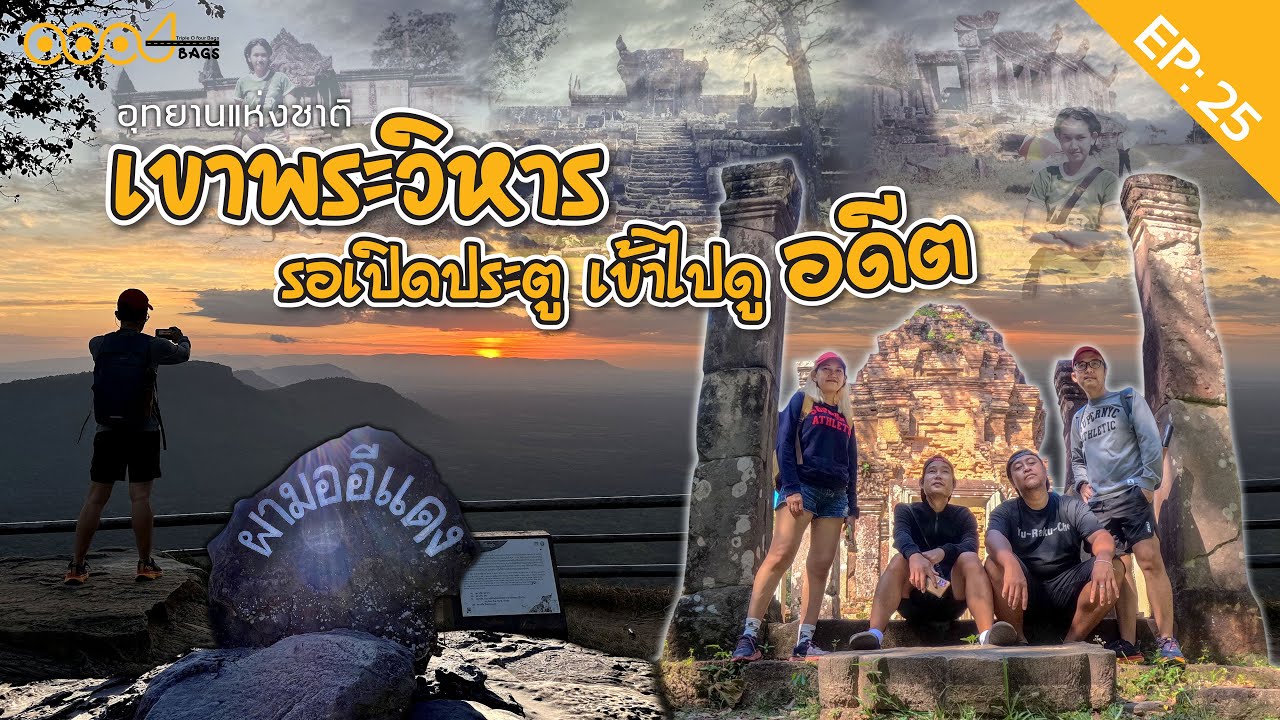
 Click to Access the Navigation Map GPS
Khao Phra Wihan National Park Map

 Art, Culture and Heritage
 Historical Sites and Monuments(12)
 Landmarks and Memorials(1)
 Art, Craft Centres, Tradition(8)
 Places of Worship
 Temple(13)
 Other Sacred Sites(3)
 Suburban Living
 Village, Community(2)
National Parks and Marine Reserves(2)
Village, Community(2)
National Parks and Marine Reserves(2)
 Dam, Reservoir, Lake(7)
 Waterfalls(5)
 River, Canal(5)
 Bays and Beaches(2)
 Entertainment and Agricultural
 Zoos and Aquariums(1)
 Farms, Parks and Ecotourism(3)


