
lovethailand home >South Travel Attractions >Satun Travel Attractions >Muang Satun >Koh Sarai > Tarutao National Park
TL;DR: Tarutao National Park is located at Andaman Sea, Satun Province, with the main visitor access via Pak Bara Pier, Pak Nam Subdistrict, La-ngu District, Satun, open Daily, Subject To The Park’s Annual Seasonal Closure Notices, hours 08.30 – 16.30.

Tarutao National Park
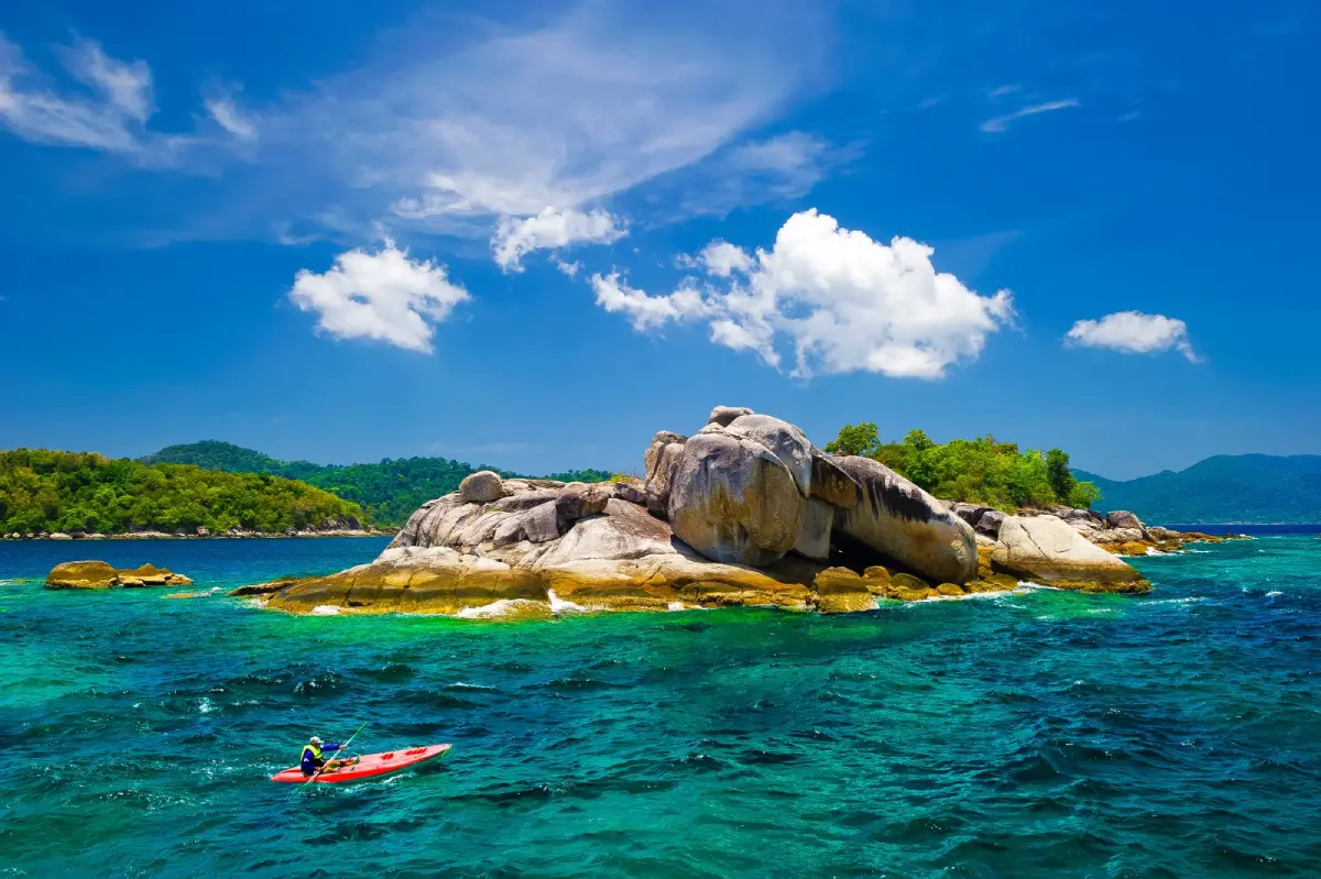
Open Days: Daily, Subject To The Park’s Annual Seasonal Closure Notices
Opening Hours: 08.30 – 16.30
Tarutao National Park in Satun Province is Thailand’s first marine national park and one of the most important protected seascapes on the southern Andaman coast. Located in the Strait of Malacca, the park lies about 40 km from Satun town and about 22 km by sea from Pak Bara Pier. It covers approximately 1,490 square kilometres and includes 51 islands divided into two main island groups: the Tarutao group and the Adang-Rawi group. The park combines islands, beaches, rainforest, mangroves, coral reefs, sea caves, viewpoints, wildlife habitats, and a powerful historical story linked with the former prison settlement on Ko Tarutao.
Tarutao National Park was declared a national park on 19 April 1974 and was later recognized as an ASEAN Heritage Park in 1982. Its value is not limited to scenic beaches. The park protects a large marine and island ecosystem with rainforests, beach forests, mangrove forests, coral communities, seagrass areas, and habitats for rare marine animals such as sea turtles, rays, and many reef species. Visitors come here not only for clear water and white sand, but also for nature conservation, quiet island travel, historical learning, and a slower form of coastal exploration.
The name Tarutao is derived from Malay wording associated with an island of many bays. This meaning fits Ko Tarutao well because the island is lined with several bays, each with its own character. Ao Phante Malacca is the main arrival area and visitor centre. Ao Chak is quiet and close to the main bay. Ao Mo Lae has a calm beach and coconut trees. Ao Son is known for its long curved beach, sea turtle nesting area, camping atmosphere, and trails to small waterfalls. Ao Talo Wao and Ao Talo Udang are deeply linked with the island’s prison history.
Ko Tarutao is the largest island in the park, covering about 152 square kilometres. Most of the island is mountainous and forested, with rainforest, mangrove channels, beaches, streams, and wildlife habitats. Wild boar, mouse deer, hornbills, reptiles, coastal birds, and marine animals are part of the island environment. Unlike heavily developed island destinations, Ko Tarutao remains simple, quiet, and protected under national park rules. It is best suited to travellers who appreciate nature, basic facilities, walking routes, and a sense of remoteness.
The history of Ko Tarutao gives the island a depth that many beach destinations do not have. In 1936, the Thai government looked for a remote location for a vocational settlement and detention site under the Department of Corrections. Ko Tarutao was chosen because it was far from the mainland, surrounded by rough sea, and difficult to escape from. Buildings for officers, prisoner dormitories, workshops, and administrative use were built at Ao Talo Wao and Ao Talo Udang.
In 1938, the first group of 500 prisoners arrived on Tarutao. The number later rose to about 3,000. In 1939, around 70 political prisoners connected with the Boworadet Rebellion and the Non-Commissioned Officers’ Rebellion were detained at Ao Talo Udang. This history makes Tarutao more than a scenic island. It is also a place of political memory, punishment, hardship, survival, and later conservation. Visitors who explore the historical areas can understand how the island once functioned as an isolated prison community before becoming a protected marine national park.
During the Second World War, the prison settlement was severely affected by shortages of food, medicine, and transport. Disease and hardship caused many deaths. Some guards and prisoners later became involved in attacks on passing merchant vessels in the Strait of Malacca, giving rise to the story of the Tarutao pirates. In 1946, British forces from Malaya, with permission from the Thai government, helped suppress the piracy. The correctional settlement was eventually closed, and the island was abandoned for many years before being declared Thailand’s first marine national park in 1974.
Ao Phante Malacca is the main gateway on Ko Tarutao. It is the location of the park office, visitor centre, pier, bungalows, camping ground, restaurant, toilets, and information displays about the island’s nature and history. The beach is long, quiet, and scenic, with clear water and a relaxed atmosphere. Many travellers on the route to Ko Lipe stop here briefly for photos and a short walk, while those staying overnight can use this bay as the base for walking, viewpoint visits, cave trips, and other nature activities.
Behind Ao Phante Malacca is Pha To Bu Viewpoint, a cliff about 60 metres above sea level. The walk takes roughly 20 minutes through dry evergreen forest. From the top, visitors can see Ao Phante Malacca, the surrounding sea, and nearby islands such as Ko Bulon, Ko Klang, Ko Khai, Ko Adang, Ko Rawi, and the Mu Ko Phetra area. Late afternoon is especially rewarding because the viewpoint is one of the best places on Ko Tarutao to watch the sunset.
Ao Chak is a smaller and quieter bay connected with the main visitor area. Ao Mo Lae is about 4 km from the park office and is known for its white sand, coconut trees, and peaceful setting. Ao Son is about 8 km from the park office and has a curved shoreline with both sand and rocks. It is also an important sea turtle nesting area and a base for walking routes to Ludu Waterfall and Lo Po Waterfall. These bays make Ko Tarutao suitable for visitors who want more than a quick photo stop.
Crocodile Cave is one of the island’s most memorable natural sites. The trip begins by long-tail boat or kayak along Khlong Phante Malacca, a mangrove-lined waterway with dense greenery on both sides. The boat ride takes about 20 minutes, followed by a short walk to the cave entrance. Inside the cave are stalactites and stalagmites, with a floating walkway through the darker inner section. Visitors should bring a flashlight and follow park guidance because the cave environment is dark, sensitive, and dependent on safe access conditions.
Ao Talo Wao on the eastern side of Ko Tarutao is one of the island’s key historical areas. It was once the site of the correctional settlement for criminal prisoners and repeat offenders. Historical interpretation in the area includes reconstructed or preserved traces of buildings such as officer residences, prisoner dormitories, workshops, and burial grounds. Ao Talo Udang, on the southern side of the island, is associated with the detention of political prisoners and is marked by a large split rock near the front of the bay. These sites explain why Tarutao is often described as a place where nature and history stand side by side.
The Adang-Rawi group is the other major island cluster within Tarutao National Park. It includes clear water, coral reefs, white beaches, and several well-known snorkelling areas. Ko Adang is the second-largest island in the park and has Laem Son Beach and Pha Chado Viewpoint, which looks toward Ko Lipe. Ko Rawi is quieter, with attractive beaches and a natural atmosphere. Ko Hin Ngam is famous for its smooth black stones, while Jabang Channel is known for colourful soft corals during the suitable season. These areas are among the reasons Tarutao is one of Thailand’s most important marine park destinations.
Ko Lipe is part of the wider Tarutao island landscape and is the best-known destination in the area because of its beaches, clear water, private accommodation, and developed tourist services. However, understanding Tarutao National Park should not be limited to Ko Lipe alone. Ko Tarutao, Ko Adang, Ko Rawi, Ko Khai, Ko Hin Ngam, Jabang Channel, and the historical bays all contribute to the park’s identity as a place of conservation, island ecology, sea travel, and cultural memory.
The main travel season for Tarutao National Park is generally from November to May, with November to April being the most popular period for sea travel. During this season, the sea is usually calmer, boat services are more frequent, and visibility for snorkelling is often better. During the southwest monsoon period, parts of the park close annually for safety and ecological recovery. For the 2026 notice, many sites in the Adang-Rawi group are closed from 1 June to 30 September 2026, with some sites closed until 31 December 2026. Ko Tarutao accommodation and camping areas, Ko Hin Ngam, and Ko Khai remain listed as accessible areas under the notice.
Activities in Tarutao National Park include beach walking, swimming, sunset viewing, hiking to Pha To Bu, visiting Crocodile Cave, walking nature trails, birdwatching, kayaking through mangroves, snorkelling in suitable areas, and joining boat trips around the islands. The trail from Ao Phante Malacca to Ao Talo Wao is about 12 km and passes through dense forest. Another route connects Ao Chak, Ao Mo Lae, and Ao Son over about 8 km. Visitors should choose activities according to weather, sea conditions, seasonal closure notices, and guidance from park staff.
Park accommodation is available in simple bungalows and camping areas at key zones such as Ao Phante Malacca on Ko Tarutao, Ao Mo Lae, and Laem Son on Ko Adang. Facilities are practical rather than luxurious. Travellers should bring essential personal items such as medication, a flashlight, mosquito protection, dry bags, reef-safe sun protection, and clothing suitable for both beach and forest conditions. Advance booking is strongly recommended, and seasonal closure information should be checked before departure.
Food and services on Ko Tarutao are limited compared with commercial island destinations. The Ao Phante Malacca area has a restaurant, toilets, accommodation, and visitor services, but visitors travelling to other bays or staying overnight should plan food, drinking water, and timing carefully. Tarutao is best for travellers who value quiet nature and can accept simpler facilities in exchange for a protected island environment.
Getting There starts at Pak Bara Pier in Pak Nam Subdistrict, La-ngu District, Satun Province. Pak Bara is the main pier and the nearest mainland access point to Ko Tarutao, about 22 km away by sea. During the travel season, private ferry and speedboat operators run services to Ko Tarutao, Ko Khai, Ko Lipe, and other islands. Some boats stop at Ko Tarutao and Ko Khai before continuing to Ko Lipe, while others travel more directly. Boat schedules depend on season, sea conditions, and operator arrangements, so travellers should check departures before arriving at the pier.
From Satun town to Pak Bara Pier by car, take Highway 406 toward Ban Chalung, continue onto Highway 416 toward La-ngu, then take Highway 4052 to Pak Bara Pier. The road distance is about 50 km. From Hat Yai, travellers can use road transport toward Satun and La-ngu before continuing to Pak Bara. From Trang, buses or vans can connect to La-ngu, followed by local transport to the pier. Travellers using public transport should allow extra time so that arrival at Pak Bara matches the boat schedule.
Before travelling, visitors should check the latest park closure notices, boat schedules, accommodation availability, weather, and sea conditions. Cash is useful for entrance fees, boat transfers, meals, and small expenses. Important items include personal documents, medicine, sunscreen, a hat, sunglasses, comfortable walking shoes or sandals, a dry bag, and a personal trash bag. Marine national park travel depends heavily on safety, weather, and conservation rules.
Responsible travel is essential in Tarutao National Park. Visitors should not step on coral, touch marine animals, collect shells or stones, feed fish, remove natural objects, or leave rubbish behind. At Ko Hin Ngam, the black stones are protected natural resources and must remain on the island. A good visit to Tarutao means enjoying the landscape without damaging the ecosystem that makes it valuable.
Tarutao National Park is ideal for travellers who want a deeper island experience than a standard beach holiday. Within one protected area, visitors can find historical prison sites, long beaches, forest trails, mangrove waterways, caves, turtle nesting beaches, coral reefs, viewpoints, and quiet accommodation. A short visit can focus on Ao Phante Malacca and Pha To Bu Viewpoint, while a longer trip can combine Ko Tarutao with Ko Adang, Ko Rawi, Ko Khai, Ko Hin Ngam, and Ko Lipe.
The lasting appeal of Tarutao is the balance between nature, history, and stillness. It is not a luxury resort island and does not offer the full convenience of a commercial beach town. Instead, it offers forested mountains, quiet bays, clear water, basic park accommodation, traces of a former prison settlement, and one of the strongest conservation identities in the Thai Andaman Sea. For travellers who want to understand Satun through both landscape and history, Tarutao National Park is one of the province’s most important destinations.
| Name | Tarutao National Park |
| Location | Andaman Sea, Satun Province, with the main visitor access via Pak Bara Pier, Pak Nam Subdistrict, La-ngu District, Satun |
| Visitor Centre Address | Pak Bara Pier Area, Pak Nam Subdistrict, La-ngu District, Satun 91110, Thailand |
| Ko Tarutao Coordinates | 6.6108, 99.6516 |
| Highlights | Thailand’s first marine national park, covering about 1,490 square kilometres and 51 islands, with rich nature, prison-island history, and ASEAN Heritage Park recognition |
| History | Declared a national park on 19 April 1974. Ko Tarutao was formerly used as a vocational settlement and prison area from the late 1930s through the Second World War period |
| Name Origin | The name Tarutao is derived from Malay wording associated with an island of many bays, matching the island’s geography |
| Distinctive Features | Sea, islands, rainforest, mangroves, beaches, coral reefs, caves, viewpoints, forest trails, and historic prison-related sites in one protected area |
| Travel Information | Travel by boat from Pak Bara Pier. The sea distance from Pak Bara Pier to Ko Tarutao is about 22 km. From Satun town, drive via Highway 406, Highway 416, and Highway 4052 to Pak Bara Pier |
| Current Status | Open according to the park’s official seasonal notices, with some islands and zones closed during the monsoon period for safety and ecological recovery |
| Open Days | Daily, Subject To The Park’s Annual Seasonal Closure Notices |
| Opening Hours | 08.30 – 16.30 |
| Main Travel Season | Around November – May, with November – April being the most popular period for boat travel and sea activities |
| Fees | Thai Visitors: Adult 40 Baht, Child 20 Baht Foreign Visitors: Adult 200 Baht, Child 100 Baht Boat fares, accommodation, and activity costs are not included |
| Facilities | Visitor centre, pier, park bungalows, camping grounds, restaurant, toilets, nature trails, viewpoint, and activity contact through park staff |
| Main Areas / Zones | Tarutao island group, Adang-Rawi island group, Ao Phante Malacca, Ao Chak, Ao Mo Lae, Ao Son, Ao Talo Wao, Ao Talo Udang, Crocodile Cave, Pha To Bu Viewpoint, Ko Khai, Ko Adang, Ko Rawi, Ko Hin Ngam, and Jabang Channel |
| Park Chief | Mr. Surachai Thathes |
| Main Contact Number | Tarutao National Park Visitor Centre Tel. 0-7478-3485 Tarutao National Park Office Tel. 0-7478-3597 |
| Official Website / Official Page | Tarutao National Park, Satun Thailand And Department Of National Parks, Wildlife And Plant Conservation |
| Nearby Tourist Attractions | 1. Ao Phante Malacca, about 0 km 2. Pha To Bu Viewpoint, about 1 km 3. Crocodile Cave, about 2 km 4. Ao Mo Lae, about 4 km 5. Ao Son, about 8 km 6. Pak Bara Pier, about 22 km |
| Nearby Restaurants | 1. Park Restaurant At Ao Phante Malacca, about 0 km 2. Laybara Coffee Pak Bara, about 22 km 3. Chom View Seafood Pak Bara, about 22 km, Tel. 087-418-9881 4. Fasai Seafood Pak Bara, about 22 km 5. Pakarang Seafood Pak Bara, about 23 km 6. Rimlay Seafood Pak Bara, about 22 km, Tel. 083-195-7844, 087-794-0699 |
| Nearby Accommodations | 1. Park Bungalows At Ao Phante Malacca, Ko Tarutao, about 0 km, Tel. 0-7478-3485 2. Park Bungalows At Ao Mo Lae, Ko Tarutao, about 4 km, Tel. 0-7478-3485 3. Ao Son Camping Area, Ko Tarutao, about 8 km, Tel. 0-7478-3485 4. Best House Resort Pakbara, about 22 km 5. Lake Terrace Resort Pak Bara, about 27 km, Tel. 081-132-8178 6. Grand Andaman Resort Pak Bara, about 26 km, Tel. 074-740-269 |
Frequently Asked Questions (FAQ)
Q: Where is Tarutao National Park located?
A: Tarutao National Park is located in the Andaman Sea in Satun Province. The main access point is Pak Bara Pier in La-ngu District, where visitors take a boat to Ko Tarutao.
Q: When is the best time to visit Tarutao National Park?
A: November to April is the best period for sea travel, boat services, snorkelling, and beach activities because the Andaman Sea is generally calmer.
Q: How much is the entrance fee for Tarutao National Park?
A: The entrance fee is 40 baht for Thai adults and 20 baht for Thai children. Foreign visitors pay 200 baht for adults and 100 baht for children. Boat fares, accommodation, and activities are separate.
Q: How do visitors get to Tarutao National Park?
A: Visitors travel to Pak Bara Pier in La-ngu District, Satun, then take a boat to Ko Tarutao. The sea distance from Pak Bara Pier to Ko Tarutao is about 22 km.
Q: Is accommodation available on Ko Tarutao?
A: Yes. Park bungalows and camping areas are available in key zones such as Ao Phante Malacca, Ao Mo Lae, and Ao Son. Advance booking and seasonal notice checks are recommended.
Q: What are the main attractions on Ko Tarutao?
A: Main attractions include Ao Phante Malacca, Pha To Bu Viewpoint, Ao Chak, Ao Mo Lae, Ao Son, Crocodile Cave, Ao Talo Wao, and Ao Talo Udang.
Q: Why is Tarutao historically important?
A: Ko Tarutao was once used as a correctional settlement and prison area in the late 1930s and during the Second World War before it became Thailand’s first marine national park in 1974.
Q: Can visitors travel to Tarutao during the monsoon season?
A: Some parts of the park close during the monsoon season for safety and ecological recovery. Visitors should check official park notices and boat schedules before travelling.
 Category: ●Nature and Wildlife
 Group: ●National Parks and Marine Reserves
Last Update : 2 MonthAgo
 Last Update : 2 MonthAgo
 Click to Access the Navigation Map GPS
Tarutao National Park Map
Recommend

 Art, Culture and Heritage
 Historical Sites and Monuments(1)
 Landmarks and Memorials(1)
 Art, Craft Centres, Tradition(5)
 Museums(3)
 Places of Worship
 Temple(3)
 Mosque(27)
 Other Sacred Sites(1)
 Suburban Living
 Village, Community(1)
 Local Market(2)
National Parks and Marine Reserves(7)
 Mountain (Doi)(1)
 Dam, Reservoir, Lake(2)
 Waterfalls(9)
 Hot Springs(1)
 Caves(9)
 Bays and Beaches(10)
 Islands(16)
 Other natural attractions(5)
 Entertainment and Agricultural
 Zoos and Aquariums(1)
 Farms, Parks and Ecotourism(4)
 Outdoor and Adventure Activities(1)
 Travel Articles, Recipes
 Travel Review, Food Review(1)


