
lovethailand home >South Travel Attractions >Ranong Travel Attractions >Kra Buri >Pak Chan > Chum Saeng Waterfall (Rainbow Waterfall)
TL;DR: Chum Saeng Waterfall (Rainbow Waterfall) is located at Ban Pak Chan, Moo 4, Pak Chan Subdistrict, Kra Buri District, Ranong Province, open Open Daily Depending On Site Conditions And Waterfall Season, hours 08:30 – 16:30.
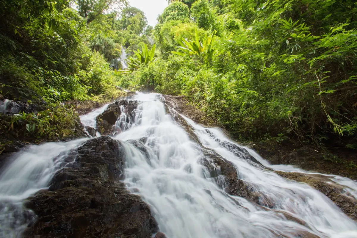
Chum Saeng Waterfall (Rainbow Waterfall)
Open Days: Open Daily Depending On Site Conditions And Waterfall Season
Opening Hours: 08:30 – 16:30
Last Updated: 2 September 2026
Chum Saeng Waterfall, also known as Sai Rung Waterfall, is a seasonal natural waterfall in Ban Pak Chan, Pak Chan Subdistrict, Kra Buri District, Ranong Province. It is located along Highway 4 on the Ranong-Chumphon route, about 80 km from Ranong Municipality and about 16 km from Kra Buri District town. The key access point is around kilometre markers 529 – 530, opposite the entrance to the Ban Pak Chan Self-Help Settlement. From the main highway, a side road leads inward for about 3 km to the waterfall area. The waterfall is especially beautiful in the rainy season, when water drops over rocks, hits the boulders below, and spreads into fine spray that can appear like a rainbow in natural light. This is why local people commonly call it Sai Rung Waterfall, or Rainbow Waterfall.
Chum Saeng Waterfall has a different character from waterfalls that flow strongly throughout the year. Its beauty is closely tied to the rhythm of the rainy season. During the rains, the water volume increases and spreads over the rock face, creating mist, movement, and the rainbow-like effect that gives the waterfall its popular name. During the dry season, water volume becomes much lower, and the visit is more about forest atmosphere, rocks, and the waterfall setting than a full curtain of water. Travelers who want to see the waterfall at its most impressive should plan for the rainy season or a safe period after rainfall.
The waterfall is physically striking for its height and broad rock face. Water descends from a high mountain area across a cliff and boulder field. The waterfall is about 60 m high, and the rock face where water spreads is about 20 m wide. When the seasonal water flow is strong, it creates a wide and textured waterfall scene rather than a single narrow drop. The combination of cliff, rocks, water spray, and light gives the site its distinctive visual identity.
Older tourism references also mention the former name Pak Wip Waterfall. Today, the attraction is better known as Chum Saeng Waterfall and Sai Rung Waterfall. The name Chum Saeng is connected with the Pak Chan area, while the name Sai Rung comes from the rainbow-like mist created when water strikes the rocks. These names make the waterfall memorable and help define it as one of Kra Buri’s seasonal nature attractions.
Pak Chan Subdistrict lies in northern Ranong near the boundary between Ranong and Chumphon. Highway 4, or Phetkasem Road, passes through the area, linking roadside communities, agricultural land, hills, streams, and forested terrain. Chum Saeng Waterfall is not far from this main route, but after turning off the highway and entering the side road, the setting gradually changes from road travel to a more natural waterfall environment. This transition is part of the appeal of visiting the site.
The most practical way to visit is by private car, rental car, or hired vehicle. From Ranong town, drive north on Highway 4 toward Kra Buri and Chumphon. After passing Kra Buri town by about 16 km, watch for the kilometre markers 529 – 530 and the side road opposite the entrance to the Ban Pak Chan Self-Help Settlement. From the highway, continue about 3 km to the waterfall area. Travelers coming from Chumphon should use the same kilometre markers before reaching Kra Buri town. Navigation should be used together with road markers and local directions.
The side road to the waterfall should be driven carefully, especially in the rainy season. Road surfaces may be wet, slippery, or affected by rainfall and local conditions. Daytime travel is recommended because visibility is better and visitors can assess the road and waterfall area more safely. Late-afternoon entry is not ideal, particularly in rain or low visibility, because the waterfall is a natural site rather than a fully serviced town attraction.
At the waterfall area, visitors encounter a shaded natural landscape, flowing water, rocks, and forest atmosphere. The lower pool can be used for resting and water play when conditions are safe, but caution is essential because some sections are several metres deep. Wet rocks, algae, spray, and humidity can also make the area slippery. The site is suitable for slow nature appreciation, photography, and quiet rest rather than careless water activity.
Water play should be limited to clearly safe areas. Visitors should not jump into pools, climb wet rocks, or move close to strong-flowing sections. Children must remain under close adult supervision at all times. Visitors who are not confident swimmers should avoid deep water. Seasonal waterfalls can change quickly after rain, so water level and current should be assessed at the site before entering the water.
The upper viewing area is another interesting part of the waterfall experience because it offers a higher perspective of the waterfall and surrounding terrain. However, visitors should go to upper viewpoints only when the path is safe, dry enough, and visible. Those unfamiliar with the route should not walk alone or leave the usual path. Roots, wet rocks, slopes, and uneven ground are common in waterfall environments.
The surrounding nature includes large trees and humid forest plants. Tourism descriptions mention trees such as takhian and khai khiao, along with lower plants such as ferns and rattans. These plants reflect Ranong’s wet forest environment and help create the shaded atmosphere around the waterfall. The area is suitable for light nature learning because visitors can observe the relationship between forest, water, rocks, and sunlight without needing a long forest trek.
The rainbow-like effect is the feature that separates Chum Saeng Waterfall from many other waterfalls in Kra Buri. When falling water strikes the rocks, spray rises into the air. If sunlight enters at the right angle, the mist can show rainbow-like colours. This depends on water volume, sunlight, timing, and weather, so it is not guaranteed on every visit. That unpredictability is part of the natural character of the place.
For photography, visitors should look for safe positions where the water spray and rock impact area are visible. Soft daylight or a moment when sunlight reaches the mist can produce the best results. Photographers should stand on stable ground and avoid stepping backwards near pool edges or climbing slippery rocks for a better angle. Areas with heavy spray are often wetter and more slippery than they first appear.
Chum Saeng Waterfall is suitable for travelers who enjoy seasonal waterfalls, forest scenery, and quieter nature stops. It can be included in a road trip between Ranong and Chumphon. Travelers coming from Ranong can use it as a northern nature stop, while travelers coming from Chumphon can visit it before continuing to Kra Buri or Ranong town. It is a good option for those driving independently and wanting a natural break from the highway.
Several nearby attractions can be combined with Chum Saeng Waterfall. These include the Chulalongkorn Royal Monogram Inscription site near the Ranong-Chumphon border, Wat Suwan Khiri Pak Chan and Phut Suwan Chedi, Song Phraek Waterfall, Bok Krai Waterfall, Kra Isthmus, Thap Li Market, and Phra Khayang Cave. Together, these places create a route that includes nature, history, geography, local food, and community culture in Kra Buri District.
The Chulalongkorn Royal Monogram Inscription is a historical roadside site on Highway 4 and adds cultural depth to the journey. Kra Isthmus is a major geographic landmark of the Malay Peninsula. Wat Suwan Khiri and Phut Suwan Chedi add a local religious and scenic element in Pak Chan. Combining these sites with Chum Saeng Waterfall gives the Kra Buri route more variety than a waterfall visit alone.
Bok Krai Waterfall is another important waterfall in Kra Buri and is better known for year-round water and a clearer nature route in some sections. Thap Li Market is useful for food stops and local products, especially the well-known Thap Li steamed buns. A route combining Chum Saeng Waterfall and Thap Li Market works well for travelers who want both a seasonal nature stop and a local food experience.
Because Chum Saeng Waterfall is strongest in the rainy season, weather planning is essential. Heavy continuous rain can create slippery roads, stronger water flow, and lower visibility. If rain has just stopped and water volume is high, visitors should enjoy the view from safe areas rather than entering the water. In the dry season, visitors should expect a quieter forest-and-rock experience rather than a full waterfall curtain.
Useful items include footwear with good grip, drinking water, a towel, spare clothes, a waterproof phone pouch, mosquito repellent, and a rubbish bag. Families with children or elderly travelers should check conditions before approaching the waterfall closely. Visitors should not bring excessive belongings into wet areas because natural waterfall terrain can be uneven and slippery.
The waterfall area is under the care of Pak Chan Subdistrict Administrative Organization and the local community. Visitors should follow local rules, avoid littering, avoid damaging streamside plants, avoid writing on rocks, avoid using chemical products in the water, and avoid loud noise. Small community nature attractions depend strongly on responsible visitor behaviour because facilities and staffing may be limited compared with major tourist destinations.
Chum Saeng Waterfall is best visited without rushing. The experience is about water, light, spray, rocks, and forest atmosphere. On the right day, the rainbow-like mist gives the waterfall its signature identity. Even when the rainbow effect is not visible, the shaded forest, boulder setting, and quiet Pak Chan landscape remain worthwhile for travelers who appreciate seasonal nature.
Getting There from Ranong town is straightforward: take Highway 4 north toward Kra Buri and Chumphon for about 80 km. After passing Kra Buri town by about 16 km, watch for kilometre markers 529 – 530, opposite the entrance to the Ban Pak Chan Self-Help Settlement. Turn into the side road and continue about 3 km to the waterfall area. From Chumphon, use Highway 4 south toward Kra Buri and watch for the same kilometre markers. Daytime travel, navigation, road markers, and local directions should be used together for the most accurate access.
In summary, Chum Saeng Waterfall, or Sai Rung Waterfall, is a distinctive seasonal waterfall in Pak Chan Subdistrict, Kra Buri District, Ranong Province. Its beauty comes from rainy-season water flowing over a high rock face, striking boulders, and creating spray that can appear like a rainbow in sunlight. The waterfall is about 60 m high, with a rock face about 20 m wide, and is reached from Highway 4 around kilometre markers 529 – 530 by a side road of about 3 km. It is suitable for travelers who enjoy waterfalls, forest scenery, photography, and road trips between Ranong and Chumphon. Visitors should plan around the rainy season, use caution around deep water and slippery rocks, prepare basic outdoor items, and keep the natural area clean.
| Name | Chum Saeng Waterfall |
| Other Names | Sai Rung Waterfall / Pak Wip Waterfall |
| Location | Ban Pak Chan, Moo 4, Pak Chan Subdistrict, Kra Buri District, Ranong Province |
| Address | Moo 4, Phetkasem Road, Pak Chan Subdistrict, Kra Buri District, Ranong Province 85110 |
| Coordinates | 10.50048, 98.88380 |
| Highlights | Seasonal rainy-season waterfall where water spray can appear like a rainbow when sunlight hits the mist |
| Distinctive Features | About 60 m high, with a rock face about 20 m wide, a lower pool, boulders, and shaded forest surroundings |
| Best Visiting Season | Rainy season or safe post-rain periods, when the waterfall has stronger flow and visible spray |
| Travel Information | Use Highway 4 on the Ranong-Chumphon route. The waterfall is about 80 km from Ranong Municipality and about 16 km from Kra Buri town, around kilometre markers 529 – 530 opposite the entrance to Ban Pak Chan Self-Help Settlement. Continue about 3 km from the side road to the waterfall |
| Current Status | Still listed as a tourism attraction in travel databases and local Ranong tourism documents |
| Open Days | Open daily depending on site conditions and waterfall season |
| Opening Hours | 08:30 – 16:30 |
| Facilities | Access from Phetkasem Road, natural waterfall area, lower pool, and scenic viewing areas. Visitors should bring personal essentials |
| Main Areas / Zones | 1. Side Road From Highway 4 2. Access Road Of About 3 km 3. Shaded Forest Area Before The Waterfall 4. Lower Pool 5. Boulder And Waterfall Cliff Area 6. Rainbow-Like Spray Viewing Area 7. Upper Viewing Route |
| Caretaker | Pak Chan Subdistrict Administrative Organization And Ban Pak Chan Community |
| Main Contact Number | Pak Chan Subdistrict Administrative Organization, Tel. 077-873-502 |
| Nearby Tourist Attractions | 1. Chulalongkorn Royal Monogram Inscription, About 3 km 2. Wat Suwan Khiri Pak Chan / Phut Suwan Chedi, About 7 km 3. Song Phraek Waterfall, About 10 km 4. Bok Krai Waterfall, About 16 km 5. Kra Isthmus, About 19 km 6. Thap Li Market, About 22 km 7. Phra Khayang Cave, About 38 km |
| Nearby Restaurants | 1. Kuai Tiao Du Di Kraduk Kaeo Pak Chan, About 9 km, Tel. 085-478-3373, 085-796-9596 2. Ko Jung PTT Fa Phinyo Kra Buri, About 16 km, Tel. 091-820-7963 3. Rim Khlong Restaurant Kra Buri Ranong, About 19 km, Tel. 086-739-7696 4. Oak Seafood Kra Buri Market, About 19 km, Tel. 088-167-8771 5. Han Yok Yuan Salapao Thap Li, About 22 km, Tel. 077-872-069, 081-891-1900 6. Thap Li Chicken Rice And Steamed Buns, About 22 km, Tel. 086-280-6869 |
| Nearby Accommodations | 1. AM Resort Kra Buri, About 10 km, Tel. 077-880-396 2. Thap Li Resort, About 22 km, Tel. 093-695-9825 3. Junkaew Resort, About 24 km, Tel. 089-292-7454 4. Khung Nam Resort, About 26 km, Tel. 083-692-6938 5. Peace Residence, About 28 km, Tel. 082-977-7163 6. Mulberry Resort, About 35 km, Tel. 088-753-9842 7. Pure House Resort, About 40 km, Tel. 099-053-6965 |
Frequently Asked Questions (FAQ)
Q: Where Is Chum Saeng Waterfall Located?
A: Chum Saeng Waterfall is located in Ban Pak Chan, Moo 4, Pak Chan Subdistrict, Kra Buri District, Ranong Province, along the Highway 4 route between Ranong and Chumphon.
Q: Why Is Chum Saeng Waterfall Also Called Sai Rung Waterfall?
A: During strong seasonal flow, water strikes the rocks and rises as fine spray. When sunlight hits the mist, it can look like a rainbow, which is why the waterfall is called Sai Rung Waterfall.
Q: Does Chum Saeng Waterfall Flow All Year?
A: Chum Saeng Waterfall is most active in the rainy season. During the dry season, water volume becomes much lower, so visitors should plan for the rainy season or safe post-rain periods.
Q: How Do Travelers Get To Chum Saeng Waterfall?
A: Take Highway 4 to kilometre markers 529 – 530, opposite the entrance to Ban Pak Chan Self-Help Settlement, then turn into the side road and continue about 3 km to the waterfall area.
Q: Is Chum Saeng Waterfall Suitable For Swimming?
A: Water play is possible at the lower pool when conditions are safe, but visitors must be careful of deep water, strong currents after rain, and slippery rocks.
Q: What Is The Best Time To Visit Chum Saeng Waterfall?
A: Morning to early afternoon during the rainy season is best, as there is enough daylight and better seasonal water flow for viewing the waterfall and mist.
Q: What Should Visitors Bring To Chum Saeng Waterfall?
A: Bring drinking water, non-slip shoes, a towel, spare clothes, a waterproof phone pouch, mosquito repellent, and a bag for carrying rubbish back out.
Q: What Nearby Places Can Be Combined With Chum Saeng Waterfall?
A: Nearby places include the Chulalongkorn Royal Monogram Inscription site, Wat Suwan Khiri Pak Chan, Bok Krai Waterfall, Kra Isthmus, Thap Li Market, and Phra Khayang Cave.
 Category: ●Nature and Wildlife
 Group: ●Waterfalls
Last Update : 3 MonthAgo
 Last Update : 3 MonthAgo
 Click to Access the Navigation Map GPS
Chum Saeng Waterfall (Rainbow Waterfall) Map
Recommend

 Art, Culture and Heritage
 Historical Sites and Monuments(4)
 Landmarks and Memorials(1)
 Royal Palace(1)
 Art, Craft Centres, Tradition(4)
 Educational Places
 Educational Gardens, Farm(1)
 Places of Worship
 Temple(12)
 Other Sacred Sites(2)
 Suburban Living
 Village, Community(2)
 National Parks and Marine Reserves(6)
 Mountain (Doi)(4)
Waterfalls(15)
 Hot Springs(3)
 Caves(4)
 River, Canal(2)
 Bays and Beaches(10)
 Islands(8)
 Other natural attractions(3)
 Travel Articles, Recipes
 Travel Review, Food Review(1)


