
lovethailand home >South Travel Attractions >Phang Nga Travel Attractions >Muang Phang Nga >Koh Pan Yi > Khao Ma Chu
TL;DR: Khao Ma Chu is located at Within Ao Phang Nga National Park, Phang Nga Province, along the boat route to Ko Panyi, open Daily, hours Ao Phang Nga National Park 08.00 – 16.30; Viewing Khao Ma Chu Depends On Boat.

Khao Ma Chu
Open Days: Daily
Opening Hours: Ao Phang Nga National Park 08.00 – 16.30; Viewing Khao Ma Chu Depends On Boat Schedules And Sea Conditions
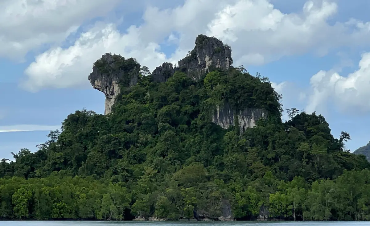
Khao Ma Chu in Phang Nga Province is a small limestone hill within the Ao Phang Nga National Park boat route. It lies along the way to Ko Panyi and is known for its natural silhouette that resembles a poodle, with a head, body, and fluffy tail. The site is viewed mainly from a boat and is usually included in Phang Nga Bay routes together with Ko Panyi, Khao Khian, Khao Phing Kan, Khao Tapu, Tham Lot, and Ko Hong. It is best understood as a scenic limestone landmark within the mangrove and karst landscape of Ao Phang Nga.
Khao Ma Chu in Phang Nga Province is one of the small but memorable limestone landmarks in Ao Phang Nga. It is not as large or globally famous as Khao Tapu or Khao Phing Kan, but it has a distinctive natural form. When viewed from the right boat angle, the hill resembles a poodle, with a head, body, and plume-like tail. This resemblance gives the hill its local identity and makes it a charming visual point on the boat route toward Ko Panyi.
Khao Ma Chu is located within the wider tourism area of Ao Phang Nga National Park, a protected marine and coastal landscape known for mangrove forests, tidal channels, limestone karsts, caves, rock shelters, ancient paintings, fishing villages, and shallow-water ecosystems. The beauty of Ao Phang Nga is different from open-sea island destinations. Its identity comes from limestone towers rising from greenish water and mangrove forests, creating a calm and dramatic landscape at the same time.
The appeal of Khao Ma Chu lies in the way geology and imagination meet. The limestone hills of Phang Nga Bay have been shaped by uplift, weathering, dissolution, wave action, tidal processes, and long-term erosion. These processes create cliffs, notches, hollows, caves, and unusual profiles. Visitors often recognize shapes in these formations, just as Khao Tapu is remembered for its nail-like form and Khao Phing Kan for its leaning rock faces. Khao Ma Chu is one of the easiest natural shapes to explain because many travelers can see the dog-like outline when the boat passes at the correct angle.
Khao Ma Chu should be understood as part of a boat route rather than a standalone destination. It lies along the way to Ko Panyi, and local boat operators or guides often point it out as the boat passes. The best view depends on distance, boat direction, tide, light, and visibility. From the right position, the poodle-like outline becomes clear. From another angle, the hill may simply look like another limestone outcrop. This is part of its charm: Khao Ma Chu rewards observation and imagination.
The surrounding environment is just as important as the rock itself. The hill sits within the mangrove and tidal-channel landscape of Ao Phang Nga. Mangroves serve as nurseries for fish, crabs, shrimp, shellfish, birds, and many small organisms. They also protect shorelines, hold sediment, and reduce wave impact. When a boat travels through the waterways near Khao Ma Chu, visitors see how limestone karsts and mangrove forests form a single ecological landscape. The hill is therefore not only a scenic shape, but also part of a living coastal ecosystem.
Ao Phang Nga National Park was declared a national park on 29 April 1981. It covers about 250,000 rai, or around 400 square kilometers, across Mueang Phang Nga, Takua Thung, and Ko Yao districts. The park contains many limestone islands and coastal formations, some with caves, prehistoric paintings, and internationally known viewpoints. In this context, Khao Ma Chu is a smaller but meaningful detail that encourages travelers to look beyond only the most famous landmarks.
Visitors should not expect to land on Khao Ma Chu. It does not have a tourist pier, walking trail, or viewpoint on the hill itself. The correct way to experience it is by boat. This protects both visitor safety and the limestone environment. Limestone cliffs can be sharp, unstable, and ecologically sensitive, with plants and animals living on ledges and cracks. Viewing the hill from a respectful distance is the best and safest approach.
The boat route that passes Khao Ma Chu usually connects with Ko Panyi, one of Phang Nga’s most famous water-based communities. Ko Panyi is a Muslim fishing village built on stilts over the water, with restaurants, souvenir shops, a mosque, school, and the well-known floating football pitch. Passing Khao Ma Chu before reaching Ko Panyi gives the route a natural transition from mangroves and limestone formations to the cultural landscape of a living community on the bay.
Khao Khian is another important site on the same route. It is a limestone rock shelter with prehistoric paintings, located north of Ko Panyi and visible from the boat. The paintings show that Phang Nga Bay has been connected with human activity for thousands of years. When Khao Ma Chu, Khao Khian, and Ko Panyi are seen together, the route becomes more than a scenic cruise. It becomes a journey through geology, archaeology, and coastal culture.
Khao Phing Kan and Khao Tapu are also often included in the same Phang Nga Bay program. Khao Phing Kan is known for its leaning rock formation, while Khao Tapu is a freestanding limestone stack with a narrow base and broader top. It became internationally famous through cinema and is now one of the most recognized images of Phang Nga. Visiting Khao Ma Chu together with these sites shows how varied limestone forms can be: a dog-like hill, leaning rocks, and a nail-shaped sea stack in one protected bay.
Tham Lot and Ko Hong add another layer to the route. Tham Lot allows small boats to pass through a limestone tunnel in suitable conditions, while Ko Hong has enclosed lagoon-like spaces surrounded by limestone cliffs. Some tours include canoeing or kayaking in these areas. Adding Khao Ma Chu to a route that includes caves and lagoons helps visitors appreciate the full range of karst landforms in Ao Phang Nga.
The best travel period for Khao Ma Chu and Ao Phang Nga is generally from November to April, when rainfall is usually lower and visibility is often better than during the southwest monsoon season. However, Phang Nga Bay is relatively sheltered compared with open-sea areas, so boat travel can be possible in many periods when weather and water conditions are suitable. Boat operators and park staff should always be followed because tides, rain, wind, and visibility affect safety and route choice.
Most visits take place during daytime. Travelers usually depart in the morning or late morning and spend about half a day to a full day depending on the route. For photography, Khao Ma Chu is often more interesting when the light comes from the side rather than directly overhead. A medium or slight telephoto view helps compress the dog-like shape, while a wider view can show the surrounding mangroves and water channels.
Khao Ma Chu is suitable for most travelers because it does not require climbing or walking. The main requirement is taking a boat. Families, children, and older travelers can enjoy the view if the boat is safe, life jackets are available, and the program is not rushed. Visitors prone to motion sickness should prepare in advance, although the bay is often calmer than open-sea island routes.
Choosing the right boat operator matters. The waterways of Ao Phang Nga include tidal channels, mangroves, shallow areas, and multiple sightseeing points. Experienced boat operators know where the best viewing angles are and how to adjust the route according to water and weather. A good guide will point out Khao Ma Chu, Khao Khian, Ko Panyi, Khao Tapu, and other features in a way that makes the route more meaningful.
Responsible travel is important in this area. Visitors should not throw rubbish into the water, feed fish, collect shells, disturb wildlife, ask the boat to get too close to mangrove roots or limestone cliffs, or use drones where they are not permitted. The mangrove roots, mudflats, and karst edges are sensitive habitats. Careless boating, anchoring, or littering can damage the same natural systems that make the bay beautiful.
Khao Ma Chu is valuable because it encourages careful observation. Many visitors focus only on the most famous points in Phang Nga Bay, especially Khao Tapu and Khao Phing Kan. Smaller features like Khao Ma Chu, Khao Khian, and the mangrove channels make the boat journey richer. They show that the bay is not a single attraction but a connected landscape of geology, ecology, culture, and local storytelling.
For travel writing, Khao Ma Chu should be presented as a scenic landmark along the route, not as a separate island attraction with facilities. Visitors do not usually book a boat only for Khao Ma Chu. They see it while traveling through Ao Phang Nga toward Ko Panyi and nearby highlights. This accurate framing helps travelers understand what to expect and prevents misunderstanding about landing, facilities, or activities on the hill itself.
Getting There usually begins at Ao Phang Nga National Park headquarters near Ban Tha Dan Pier in Ko Panyi Subdistrict, Mueang Phang Nga District. From Phang Nga town, travelers can drive to Ban Tha Dan in about 8 to 9 kilometers. Another option is Surakul Pier in Takua Thung District, depending on the tour program and where travelers are staying. Boat programs vary, so travelers should confirm in advance whether the route passes Khao Ma Chu, Ko Panyi, Khao Khian, Khao Phing Kan, Khao Tapu, Tham Lot, or Ko Hong.
By car from Bangkok, take Highway 4 south toward Phang Nga. From Phang Nga town, continue toward the national park and Ban Tha Dan Pier. Travelers flying in usually use Phuket International Airport, then continue by car to Phang Nga. Rail travelers can arrive at Phunphin Station in Surat Thani and continue by road to Phang Nga. Long-distance bus travelers can arrive at Phang Nga Bus Terminal and continue by local transport or hired vehicle to the pier.
After boarding at Ban Tha Dan, the boat route passes mangrove channels and limestone scenery before reaching the inner bay and major points such as Khao Ma Chu, Khao Khian, Ko Panyi, Khao Phing Kan, and Khao Tapu. Some programs may include canoeing at caves or lagoon areas. The right route depends on travel time, tide, operator arrangement, and weather.
A practical half-day trip can include Khao Ma Chu, Khao Khian, Ko Panyi, Khao Phing Kan, and Khao Tapu. A longer program can add Tham Lot, Ko Hong, canoeing, or more time for lunch at Ko Panyi. Visitors who enjoy photography should tell the guide in advance so the boat can slow down at suitable viewpoints when safe.
Useful items include a hat, sunglasses, sun protection, waterproof phone bag, camera, drinking water, motion sickness medicine, and footwear suitable for boat transfer. Travelers should wear a life jacket while on the boat and keep belongings secure because wind and water spray are common during boat movement.
In summary, Khao Ma Chu is a small but distinctive natural landmark in Phang Nga Bay. Its value is not in size or the number of activities, but in its memorable poodle-like limestone shape and its connection with the wider Ao Phang Nga landscape. Seen together with mangroves, Ko Panyi, Khao Khian, Khao Tapu, and Khao Phing Kan, it becomes one of the details that make a Phang Nga Bay boat journey more observant, layered, and meaningful.
| Name | Khao Ma Chu |
| Location | Within Ao Phang Nga National Park, Phang Nga Province, along the boat route to Ko Panyi |
| National Park Contact Address | Ao Phang Nga National Park, 80 Moo 1, Ban Tha Dan Road, Ko Panyi Subdistrict, Mueang Phang Nga District, Phang Nga 82000, Thailand |
| Park Headquarters Coordinates | 8.3065613, 98.4555569 |
| Place Type | Small limestone hill viewed from a boat, known for a natural shape resembling a poodle |
| Highlights | Dog-like limestone silhouette, mangrove scenery, Ko Panyi boat route, Ao Phang Nga karst landscape, and boat-based photography |
| Significance | A small scenic karst landmark that adds local storytelling and observation value to Phang Nga Bay boat trips |
| Related National Park Area | Ao Phang Nga National Park covers about 250,000 rai or about 400 square kilometers across Mueang Phang Nga, Takua Thung, and Ko Yao districts |
| Open Days | Daily |
| Opening Hours | Ao Phang Nga National Park 08.00 – 16.30; viewing Khao Ma Chu depends on boat schedules and sea conditions |
| Fees | Thai adults 60 baht, Thai children 30 baht / foreign adults 300 baht, foreign children 150 baht / car 30 baht / motorcycle 20 baht |
| Current Status | A boat-view limestone landmark on the Ao Phang Nga National Park sightseeing route |
| Caretaker | Department of National Parks, Wildlife and Plant Conservation through Ao Phang Nga National Park |
| Park Contact Numbers | 076-481-188, 076-481-163 |
| Main Route Areas | Khao Ma Chu, Ko Panyi, Khao Khian, Khao Phing Kan, Khao Tapu, Tham Lot, Ko Hong, Ko Phanak, and Ao Phang Nga mangrove areas |
| Travel Information | Travel about 8–9 km from Phang Nga town to Ban Tha Dan Pier, then continue by sightseeing boat in Ao Phang Nga. Surakul Pier in Takua Thung District is another common departure point depending on the tour program. |
| Recommended Activities | Boat sightseeing, photographing Khao Ma Chu from the boat, viewing mangroves, visiting Ko Panyi, seeing Khao Khian paintings, visiting Khao Phing Kan and Khao Tapu, and canoeing where available |
| Nearby Tourist Attractions | 1. Ko Panyi, about 7 km from Ban Tha Dan Pier by boat 2. Khao Khian, about 7 km from the national park pier by boat 3. Khao Phing Kan And Khao Tapu, about 15 km from the park office via Khlong Ko Panyi 4. Tham Lot, about 10 km by boat route 5. Ko Hong, about 12 km by boat route 6. Samet Nangshe Viewpoint, about 22 km by road from Ban Tha Dan Pier |
| Nearby Restaurants | 1. Ao Phang Nga National Park Welfare Restaurant, about 0 km from Ban Tha Dan Pier 2. Newfern Restaurant, Ko Panyi, about 7 km by boat, Tel. 081-677-8985 3. Mee Giew Pae Suan, Kalai, about 14 km, Tel. 064-992-9996 4. J’Nong Local Phang Nga Restaurant, about 18 km, Tel. 095-423-2624, 087-464-0509 5. Ja Charan Restaurant, Mueang Phang Nga, about 10 km 6. Restaurants On Ko Panyi, about 7 km by boat |
| Nearby Accommodations | 1. Ao Phang Nga National Park Accommodation, Ban Tha Dan, Tel. 076-481-188, 076-481-163 2. Bang Nu River Homestay, about 8 km, Tel. 086-947-2456 3. Pakor Boutique Resort, about 12 km, Tel. 093-606-2255 4. Home Phang-Nga Guest House, about 10 km, Tel. 081-958-5538 5. Accommodations In Phang Nga Town, about 8–12 km 6. Accommodations Around Samet Nangshe And Takua Thung, about 20–30 km |
Frequently Asked Questions (FAQ)
Q: Where is Khao Ma Chu located?
A: Khao Ma Chu is located within Ao Phang Nga National Park in Phang Nga Province, along the boat route to Ko Panyi. It is viewed mainly from a boat.
Q: What is special about Khao Ma Chu?
A: Its limestone silhouette resembles a poodle, with a head, body, and fluffy tail, making it a memorable natural landmark on the Phang Nga Bay boat route.
Q: Can visitors land on Khao Ma Chu?
A: No. It is not a landing or walking site. Visitors should view it from the boat because there is no tourist pier or walking trail on the limestone hill.
Q: How much is the national park entrance fee?
A: Thai adults pay 60 baht and Thai children pay 30 baht. Foreign adults pay 300 baht and foreign children pay 150 baht. Vehicle fees are charged separately.
Q: Which pier is best for visiting Khao Ma Chu?
A: Ban Tha Dan Pier near Ao Phang Nga National Park headquarters is a common departure point. Surakul Pier in Takua Thung District is another option depending on the tour program.
Q: What other places can be visited on the same boat route?
A: Common nearby stops include Ko Panyi, Khao Khian, Khao Phing Kan, Khao Tapu, Tham Lot, Ko Hong, and mangrove areas in Ao Phang Nga.
Q: When is the best time to visit Khao Ma Chu?
A: November to April is generally the most suitable period because rain is usually lower and visibility is often better, but travel depends on daily weather and sea conditions.
Q: What should visitors prepare for the boat trip?
A: Bring a hat, sunglasses, sun protection, waterproof bag, camera, drinking water, motion sickness medicine, and wear a life jacket while on the boat.
 Category: ●Nature and Wildlife
 Group: ●Mountain (Doi)
Last Update : 3 MonthAgo
 Last Update : 3 MonthAgo

 Click to Access the Navigation Map GPS
Khao Ma Chu Map
Recommend

 Art, Culture and Heritage
 Historical Sites and Monuments(2)
 Landmarks and Memorials(6)
 Art, Craft Centres, Tradition(3)
 University
 Public university(1)
 Places of Worship
 Temple(18)
 Other Sacred Sites(8)
 Suburban Living
 Village, Community(3)
 National Parks and Marine Reserves(12)
Mountain (Doi)(9)
 Waterfalls(21)
 Hot Springs(2)
 Caves(12)
 River, Canal(4)
 Bays and Beaches(28)
 Islands(13)
 Other natural attractions(7)
 Entertainment and Agricultural
 Animal camps and shows(2)
 Farms, Parks and Ecotourism(2)
 Waterpark(3)
 Outdoor and Adventure Activities(3)
 Travel Articles, Recipes
 Travel Review, Food Review(1)
 Southern Food Menu, Southern Food Recipes(1)


