
lovethailand home >South Travel Attractions >Phang Nga Travel Attractions >Thai Mueang >Thai Mueang > Khao Lampi-Hat Thai Mueang National Park
TL;DR: Khao Lampi-Hat Thai Mueang National Park is located at Thai Mueang District, Phang Nga Province, covering Lam Kaen, Thung Maphrao, Thai Mueang, Bang Thong, and Na Toei subdistricts, open Daily, hours 08.30 – 16.30.

Khao Lampi-Hat Thai Mueang National Park
Open Days: Daily
Opening Hours: 08.30 – 16.30
Khao Lampi-Hat Thai Mueang National Park in Phang Nga Province combines tropical evergreen forest, waterfalls, streams, beach forest, mangroves, Melaleuca woodland, and the long Andaman coastline of Hat Thai Mueang in one protected area. Key highlights include Hat Thai Mueang Beach, Lam Pi Waterfall, Ton Phrai Waterfall, the Melaleuca woodland, Khao Na Yak, and the sea turtle conservation landscape. The park is suitable for nature travelers who want beaches, waterfalls, rainforest, birdwatching, camping, coastal learning, and a deeper understanding of Phang Nga’s Andaman ecosystems.
Khao Lampi-Hat Thai Mueang National Park is one of Phang Nga’s most complete nature destinations because it protects both mountain forest and Andaman coastline within the same national park. The park is located in Thai Mueang District and covers areas of Lam Kaen, Thung Maphrao, Thai Mueang, Bang Thong, and Na Toei subdistricts. Its headquarters is located near Hat Thai Mueang Beach, giving visitors immediate access to a quiet coastal landscape while also keeping the rainforest and waterfall zone within practical driving distance.
The park was declared a national park on 14 April 1986. It covers about 45,000 rai, or roughly 72 square kilometers. The landscape is divided into two main sections: the Khao Lampi mountain range inland and Hat Thai Mueang on the Andaman coast. Highway 4, also known as Phet Kasem Road, effectively separates these two landscape systems. This makes the park unusual and convenient, because visitors can experience rainforest waterfalls, streams, beach forest, mangroves, coastal sand ridges, and sea turtle conservation areas in a single day.
The Khao Lampi mountain section consists of several mountains aligned roughly north to south, including Khao Khanim, Khao Lampi, Khao Ton Yan Sai, and Khao Lam Lang. The highest peak is Khao Khanim at about 622 meters above sea level. This mountain area is an important watershed for many streams, including Khlong Lam Pi, Khlong Khanim, Khlong Lam Lang, Khlong Phlu, Khlong Kham Nueng, Khlong Inthanin, and Khlong Bang Po. These streams support the waterfalls, local water systems, and natural habitats around Thai Mueang.
Geologically, the area is significant because the Khao Lampi range includes granite of Triassic to Cretaceous age, roughly 60 to 140 million years old. These granite formations shape the mountains, streams, and waterfalls of the park. For travelers interested in nature interpretation, the park offers more than scenery; it reveals the relationship between geology, forest, water, and coastal ecosystems.
The mountain section is covered mainly by tropical evergreen forest. Important tree species include yang, lumpho, takhian thong, bunnak, krabak, and other large rainforest trees. Ferns, rattans, bamboo, and moisture-loving plants grow beneath the canopy, especially near streams. This forest atmosphere is cool, shaded, and humid, creating a strong contrast with the beach area only a short drive away.
Wildlife in the rainforest section includes mammals and birds such as barking deer, deer, wild boar, mouse deer, porcupines, leopard cats, civets, monkeys, langurs, gibbons, and many forest birds. The coastal section supports shorebirds, water birds, beach wildlife, and marine life. Hat Thai Mueang is especially important because it has long been associated with sea turtle nesting. Although sea turtle numbers have declined compared with the past, recent monitoring and nesting events show that the beach remains ecologically significant.
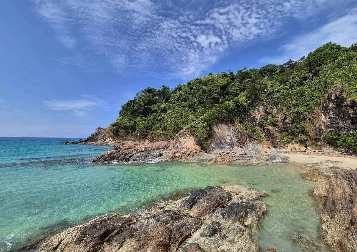
Hat Thai Mueang is the main coastal highlight of the park. It stretches for about 13.6 kilometers along the Andaman Sea. The beach is long, open, and relatively quiet compared with more heavily developed beaches in southern Thailand. During suitable weather and sea conditions, visitors can enjoy beach walks, photography, sea views, and relaxation. The area is not only a recreational beach; it is also a conservation landscape linked with sea turtles, beach forest, coastal sand ridges, and local environmental activities.
One of the beach’s most meaningful identities is its relationship with sea turtles. The November to February period is associated with sea turtle nesting, while the release of young turtles is traditionally connected with activities in March. This local conservation tradition gives Hat Thai Mueang cultural and ecological value. Visitors should understand that the beach is not only for recreation. It is also a sensitive habitat where light, noise, waste, and disturbance can affect rare marine animals.
The Melaleuca woodland, or Thung Samet, is another distinctive landscape in the central area of Hat Thai Mueang. It covers about 1,000 rai and consists mainly of white Melaleuca trees growing on fine white sandy soil. During the rainy season, some areas hold freshwater, giving the site a swamp-like character. The white-trunked trees and quiet forest atmosphere make this area different from a typical beach setting. Visitors should stay on suitable routes and avoid damaging the fragile coastal woodland.
Khao Na Yak, also known as Laem Ao Kham, lies toward the end of the beach and adds another coastal dimension to the park. It is a quieter natural area suitable for coastal scenery, beach walking, and understanding the transition between beach forest, sand, and the open Andaman Sea. This area helps make Hat Thai Mueang more than a simple long beach; it is a continuous coastal landscape with ecological and scenic variety.
Lam Pi Waterfall is one of the park’s best-known inland attractions. It originates from the Khao Lampi range and has four tiers. The lowest level forms a large natural pool where visitors can swim when conditions are safe and permitted by park staff. The surrounding forest is lush and shaded. To reach the second tier, visitors cross a suspension bridge over the stream and continue on a forest path for about 150 meters. The second tier is higher and often stronger than the first. A historic inscription from Field Marshal Plaek Phibunsongkhram’s visit in 1955 can be seen on the waterfall cliff during periods of lower water.
Lam Pi Waterfall is suitable for families because it is relatively easy to access and has visitor facilities such as parking, resting areas, a walking path, and designated safe water areas. Still, visitors should be careful on slippery rocks, avoid climbing the waterfall, and never enter the water during heavy rain or strong current conditions. Waterfalls in tropical forest can change quickly after rainfall, so official guidance must always be followed.
Ton Phrai Waterfall is another major waterfall in the park. It is a large waterfall associated with Khao Ton Yan Sai and is surrounded by dense, shady forest. Ton Phrai feels wilder than Lam Pi because visitors walk through a nature trail before reaching the waterfall. It is well suited to travelers who want a stronger rainforest experience and who are comfortable with a more natural walking route.
The park also includes other points of interest such as the old mining dredge, the giant gear, Khanim Waterfall, and several nature interpretation routes. These places show that Thai Mueang has both natural and historical layers. However, access to some sites may change according to season, water level, ecological recovery, or safety conditions. In 2026, Khanim Waterfall was announced as temporarily closed for ecosystem recovery and visitor safety because of unusually low water levels, while the main areas such as Lam Pi Waterfall, Ton Phrai Waterfall, Hat Thai Mueang, and Khao Na Yak remained available under park conditions.
The best time to visit depends on the activity. For beach travel, the drier period from December to April is generally more suitable. For waterfalls, periods with adequate rainfall make the scenery more impressive, but visitors must pay attention to flash flood risk, slippery surfaces, and temporary closure announcements. Those interested in sea turtle conservation should follow annual announcements related to turtle activities, especially around March.
Activities in the park include nature walks, waterfall visits, plant observation, birdwatching, butterfly watching, wildlife observation, stargazing, cycling, mountain biking, and camping. The headquarters area offers national park accommodation and camping, including bungalow units such as Chik Thale and Son Thale houses. The park does not have regular shops or restaurants inside, so visitors should prepare drinking water, meals, snacks, and essential supplies before entering.
The entrance fee belongs to Group 1 of Thailand’s national park fee structure. Thai adults pay 20 baht and Thai children pay 10 baht. Foreign adults pay 100 baht and foreign children pay 50 baht. Vehicle fees are charged separately, including 30 baht for a four-wheeled car and 20 baht for a motorcycle. Visitors should keep their entrance tickets with them while inside the park for inspection.
Responsible behavior is essential. Visitors should not litter, feed wildlife, collect plants, collect shells, disturb animals, make loud noise, start fires in sensitive areas, or drive onto beach or forest areas where vehicles are not permitted. In sea turtle areas, visitors should avoid lights, noise, and disturbance at night, and should never approach turtle tracks or nesting areas unless guided by authorized staff.
Getting There is straightforward by road. From Bangkok, take Highway 4, Phet Kasem Road, south toward Phang Nga. From Takua Pa, travel toward Thai Mueang for about 66 kilometers. From Phang Nga town, travel to Thai Mueang for about 56 kilometers. At the Thai Mueang market intersection, continue along the coastal road for about 6 kilometers to reach the park headquarters near Hat Thai Mueang. To visit Lam Pi Waterfall, continue from Thai Mueang toward the waterfall entrance for about 9 kilometers, then follow the paved access road for about 2 kilometers.
Travelers from Phuket can cross Sarasin Bridge into Phang Nga, follow Highway 4 through Khok Kloi toward Thai Mueang, and continue to the coastal road. Travelers staying in Khao Lak can drive south toward Lam Kaen and Thai Mueang. A private car or rental car is the most convenient option because the park’s beach and waterfall zones are separated. A good one-day route can begin with Lam Pi Waterfall in the morning, continue to Ton Phrai Waterfall or the Melaleuca woodland, and end with sunset at Hat Thai Mueang.
Khao Lampi-Hat Thai Mueang National Park is valuable because it has not been turned into a heavily commercial tourist zone. It protects rainforest watersheds, year-round waterfalls, a long quiet beach, Melaleuca woodland, mangroves, coastal habitats, and sea turtle conservation areas. Visitors who follow park rules and travel with environmental awareness will find one of Phang Nga’s most complete nature experiences here.
| Name | Khao Lampi-Hat Thai Mueang National Park |
| Location | Thai Mueang District, Phang Nga Province, covering Lam Kaen, Thung Maphrao, Thai Mueang, Bang Thong, and Na Toei subdistricts |
| Headquarters Address | 60/10 Moo 5, Thai Mueang Subdistrict, Thai Mueang District, Phang Nga 82120, Thailand |
| Area | About 45,000 rai, or about 72 square kilometers |
| National Park Declaration | 14 April 1986 |
| Distinctive Features | Two main ecosystems: Khao Lampi rainforest and watershed area, and Hat Thai Mueang coastal zone with beach forest, mangroves, Melaleuca woodland, and sea turtle nesting habitat |
| Highlights | Hat Thai Mueang Beach, Melaleuca woodland, Lam Pi Waterfall, Ton Phrai Waterfall, Khao Na Yak, old mining dredge, giant gear, nature trails, and sea turtle conservation areas |
| Open Days | Daily |
| Opening Hours | 08.30 – 16.30 |
| Fees | Thai adults 20 baht, Thai children 10 baht / foreign adults 100 baht, foreign children 50 baht / car 30 baht / motorcycle 20 baht |
| Current Status | Main visitor areas such as Hat Thai Mueang, Lam Pi Waterfall, Ton Phrai Waterfall, and Khao Na Yak remain available under park conditions; Khanim Waterfall has a temporary closure announcement for ecological recovery and safety |
| Park Chief | Ms. Panatthaphon Ketsakun |
| Caretaker | Department of National Parks, Wildlife and Plant Conservation |
| Contact Numbers | 0-7667-9134 Headquarters / 0-7667-9135 Fee Checkpoint / 0-7667-9136 Visitor Center |
| lampi_np@hotmail.com | |
| Facilities | Visitor center, national park accommodation, camping area, parking, nature trails, designated safe swimming areas, toilets, and main visitor-service zones |
| Important Note | There are no regular shops or restaurants inside the park. Visitors should bring food, drinking water, and essential supplies. |
| Travel Information | Use Highway 4 to Thai Mueang District. From Thai Mueang market intersection, continue along the coastal road for about 6 km to the park headquarters. For Lam Pi Waterfall, continue about 9 km from Thai Mueang to the waterfall entrance and follow the paved road about 2 km. |
| Nearby Tourist Attractions | 1. Hat Thai Mueang Beach, about 0 km 2. Melaleuca Woodland, about 2 km 3. Lam Pi Waterfall, about 11 km 4. Ton Phrai Waterfall, about 18 km 5. Phang Nga Coastal Aquaculture Research And Development Center, about 6 km 6. Thap Lamu Pier, about 20 km |
| Nearby Restaurants | 1. Thai Rang Restaurant, about 10 km, Tel. 083-090-4426 2. Ruekhoodrae, about 12 km, Tel. 096-636-3388 3. Thai Mueang Phuket Local Food Restaurant, about 12 km, Tel. 062-556-9265 4. Mee Suk At Thai Mueang Camping, about 15 km, Tel. 084-060-1818 5. Restaurants In Thai Mueang Town, about 6–12 km |
| Nearby Accommodations | 1. Khao Lampi-Hat Thai Mueang National Park Accommodation, about 0 km, Tel. 07-641-0360 2. Makai NAP, about 6 km, Tel. 084-186-6383 3. Thai Mueang Resort, about 7 km, Tel. 076-571-151 4. Thai Mueang Camping, about 15 km, Tel. 084-060-1818 5. The Hotspring Beach Resort & Spa, about 22 km, Tel. 076-580-000 |
Frequently Asked Questions (FAQ)
Q: Where is Khao Lampi-Hat Thai Mueang National Park located?
A: It is located in Thai Mueang District, Phang Nga Province. The headquarters is at 60/10 Moo 5, Thai Mueang Subdistrict, Thai Mueang District, Phang Nga.
Q: What are the opening hours?
A: The park is open daily from 08.30 to 16.30. Some individual attractions may temporarily close depending on water level, weather, or safety conditions.
Q: How much is the entrance fee?
A: Thai adults pay 20 baht and Thai children pay 10 baht. Foreign adults pay 100 baht and foreign children pay 50 baht. Vehicle fees are charged separately.
Q: What is special about Hat Thai Mueang Beach?
A: Hat Thai Mueang is about 13.6 km long, quiet, natural, and important for sea turtle conservation. It also includes beach forest, Melaleuca woodland, and a scenic Andaman coastline.
Q: Is Lam Pi Waterfall suitable for families?
A: Yes. Lam Pi Waterfall is relatively easy to access and has a large natural pool in the lower area. Visitors should still watch for slippery rocks and follow park safety instructions.
Q: How is Ton Phrai Waterfall different from Lam Pi Waterfall?
A: Ton Phrai Waterfall offers a more forested and nature-trail experience, making it suitable for visitors who want a deeper rainforest atmosphere.
Q: Is accommodation available inside the park?
A: Yes. The park has national park accommodation and camping areas near the headquarters. Advance booking and contact with park staff are recommended.
Q: When is the best time to visit?
A: For the beach, December to April is generally more suitable. For waterfalls, visit when there is enough water but always check weather and safety announcements. Turtle-related activities are commonly associated with March.
 Category: ●Nature and Wildlife
 Group: ●National Parks and Marine Reserves
Last Update : 2 MonthAgo
 Last Update : 2 MonthAgo
 Click to Access the Navigation Map GPS
Khao Lampi-Hat Thai Mueang National Park Map
Recommend

 Art, Culture and Heritage
 Historical Sites and Monuments(2)
 Landmarks and Memorials(6)
 Art, Craft Centres, Tradition(3)
 Places of Worship
 Temple(18)
 Other Sacred Sites(8)
 Suburban Living
 Village, Community(3)
National Parks and Marine Reserves(12)
 Mountain (Doi)(8)
 Waterfalls(21)
 Hot Springs(2)
 Caves(12)
 River, Canal(4)
 Bays and Beaches(28)
 Islands(11)
 Other natural attractions(7)
 Entertainment and Agricultural
 Animal camps and shows(2)
 Farms, Parks and Ecotourism(2)
 Waterpark(3)
 Outdoor and Adventure Activities(3)
 Travel Articles, Recipes
 Travel Review, Food Review(1)
 Southern Food Menu, Southern Food Recipes(1)


