
lovethailand home >South Travel Attractions >Nakhon Si Thammarat Travel Attractions >Na Bon >Na Bon > Khao Men
TL;DR: Khao Men, Nakhon Si Thammarat attractions : Nature and Wildlife, Mountain (Doi).
Khao Men
Open Days: Open according to the national park and trail-management schedule. The Khao Men trekking route should be planned during the official trekking season, while Namtok Yong National Park closes tourism and overnight stays from 1 July – 30 November
Opening Hours: 08.30 – 16.30 for park service contact. Trekking start times must follow park staff or route coordinator instructions
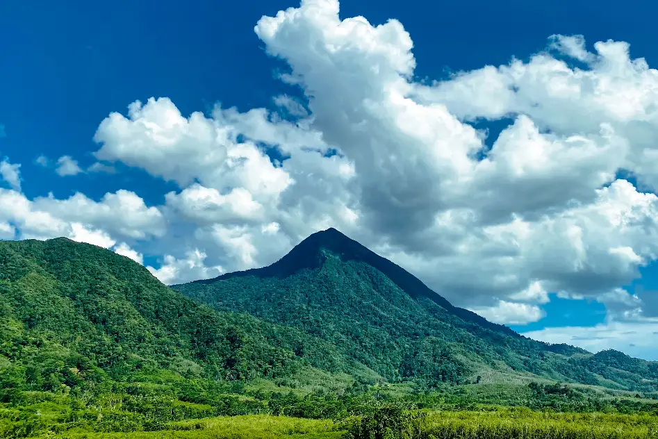
Khao Men, also known in local legend as Khao Phra Sumeru, is one of the most distinctive mountain destinations in Nakhon Si Thammarat Province. Rising to about 1,307 meters above sea level, it is the highest peak in Namtok Yong National Park and a well-known short overnight trekking route in southern Thailand. The mountain has a striking pyramid-like shape and stands prominently above the surrounding communities. Its summit is cool, windy, and often covered with mist or clouds. Khao Men is valued not only for sunrise, sunset, and sea-of-mist views, but also for its role as a watershed forest, wildlife habitat, and conservation landscape shaped by local community awareness.
The mountain is closely connected with communities around the lower slopes in Chang Klang, Na Bon, and Chawang districts. Local conservation efforts grew from the recognition that Khao Men is more than a scenic mountain. It is forest, water source, animal habitat, and community life-support system. People from different occupations joined together to support Khao Men conservation under the principle that “forest is home, stream is life.” The Khao Men Conservation Club of Nakhon Si Thammarat was established with Phraeo Pho Thong as a group leader, and its membership extended across the province. This conservation background is central to understanding Khao Men as a destination.
Khao Men is the highest peak of Namtok Yong National Park. The most commonly described summit route begins around Noen 499 and is about 3.5 kilometers long. Although the distance is not very long, the route climbs steeply and continuously, so it should not be treated as an easy casual walk. Hikers pass through humid southern forest, soil paths, roots, rocks, mossy sections, open viewpoints, and windy summit areas. The route is popular as a 2-day 1-night trek because it allows hikers to watch both sunset and sunrise from the mountain.
The name Khao Phra Sumeru reflects older belief connected with the Hindu-Brahmanical heritage of Nakhon Si Thammarat. In traditional cosmology, Mount Sumeru is associated with sacred geography and divine residence. Over time, local people shortened the name to Khao Meru or Khao Men. This gives the mountain cultural depth beyond its physical landscape. Visitors are not only entering a rainforest summit route but also a mountain surrounded by long-standing local stories and belief.
The forest of Khao Men is a hill evergreen forest with an ancient rainforest atmosphere. In many higher sections, trees are relatively low and the canopy is fairly even, while trunks, branches, rocks, and ground surfaces are covered with moss, ferns, epiphytes, and wild orchids. The forest is rich with small but ecologically important plants such as mosses, begonias, gingers, ferns, and orchids. One of the important species mentioned in travel and nature information is the southern form of the lady’s slipper orchid, which reflects the botanical value of this mountain forest.
At the summit viewpoint, hikers can see a wide landscape when the sky is clear. The view includes areas of Na Bon, Thung Song, Chang Klang, and Lan Saka districts. Sunrise and sunset are the key highlights. In the morning, mist may flow across the valleys below, while evening light can fall across the forested ridges and communities beneath the mountain. These changes in light, wind, cloud, and mist make Khao Men one of Nakhon Si Thammarat’s most memorable trekking viewpoints.
A typical Khao Men trek takes 2 days and 1 night. On the first day, hikers walk up from the lower trail area to the overnight zone near the summit. The walk usually takes several hours depending on fitness, weather, and pack weight. The steepness of the trail requires a steady pace. Near the summit, the camping or resting space is limited, and many hiking groups prefer hammocks with rain flysheets instead of large tents. On the second day, hikers wake before dawn for sunrise, then pack up and descend by the same route.
Khao Men is often described by hikers as a southern forest route with fewer leech problems than many other wet rainforest trails. However, this should not lead to careless preparation. The forest is still humid, and hikers may face insects, mosquitoes, ticks, slippery soil, wet rocks, roots, and strong wind. The descent can be harder on the knees than the climb. Proper trail shoes with deep tread, quick-dry clothing, rain protection, a headlamp, waterproof bags, insect repellent, and rubbish bags are essential.
Water planning is important. Some field reviews mention a natural water source near the summit that can be filtered, but hikers should not depend on it without preparation. Each person should carry enough water for the ascent, and groups planning to use natural water should bring filters or purification methods. Food should be lightweight, high-energy, and easy to pack out. Every piece of waste, including food packaging and tissue, must be brought back down.
Trekking Khao Men requires advance contact with Namtok Yong National Park or local route coordinators. Visitors should not attempt the route independently without permission or coordination. The trail lies in a protected area, has seasonal restrictions, and requires safety checks for weather, trail condition, group size, camping area, and overnight rules. Namtok Yong National Park tourism and overnight stays are closed from 1 July to 30 November, so every trip must begin with confirmation of the current opening schedule.
The best trekking season depends on the park’s official opening period. Local tourism information identifies December to April as the usual trekking period, while park information shows seasonal closure from July to November. Early-year trips are popular because the weather can be cooler and sea-of-mist conditions are often attractive. Even during the preferred season, however, hikers must be ready for strong wind, sudden mist, wet conditions, and fast-changing weather.
The conservation meaning of Khao Men is as important as the trek itself. The mountain forest collects rainfall, stores moisture, and feeds streams that sustain the communities below. When local conservation groups say that forest is home and streams are life, the phrase reflects a real ecological relationship. If the forest is damaged, the water system is affected. If streams decline, both people and wildlife suffer. Visitors should therefore enter the forest with respect, not only with the goal of reaching the summit.
Responsible trekking behavior is essential. Hikers should stay on the route, avoid stepping on fragile moss and ground plants, never collect orchids or wild plants, avoid campfire damage, keep noise low, and bring all rubbish out. The highland forest recovers slowly, and increased visitor numbers can harm soil, vegetation, streams, and wildlife if not managed carefully. Khao Men should be treated as a living watershed forest rather than a simple adventure playground.
Travelers who are not ready for the overnight trek can still experience the Khao Men landscape from nearby areas. Wat Na Khao Men is a good viewpoint and cultural stop where visitors can see the mountain clearly. Namtok Khlong Chang, the Khlong Chang ranger station area, and Namtok Yong National Park also help visitors understand the surrounding forest and watershed landscape. These nearby places make it possible to appreciate Khao Men without climbing to the summit.
Namtok Yong National Park, which manages the Khao Men area, covers several districts including Thung Song, Chang Klang, Lan Saka, Ron Phibun, and Na Bon. Its terrain is complex mountain forest with moist evergreen and hill evergreen vegetation. The park’s important attractions include Yong Waterfall, Plio Waterfall, Khao Men Peak, Ram Rom Peak, and camping or accommodation services in designated areas. This broader national park context shows that Khao Men is part of a larger protected forest system.
Getting There can be planned via several routes. From Nakhon Si Thammarat City, travel toward Thung Song, then continue toward Na Bon or Chang Klang depending on the route coordinator’s meeting point. Tourism information describes the route from Nakhon Si Thammarat toward Thung Song, turning at Khuan Mai Daeng junction toward Na Bon, then using local road NS 2001 for about 11 kilometers to Namtok Khlong Chang. Another common approach is from Thung Song via Highway 41, turning toward Na Bon and Ban Khlong Chang, then continuing to the park ranger unit where hikers coordinate permission for the Khao Men trek.
Hikers should arrive in the area early, preferably half a day or one day before the trek. This allows time to organize gear, confirm route conditions, prepare water and food, coordinate with park staff or local guides, and evaluate weather conditions. Groups should clearly divide personal gear, group equipment, cooking supplies, and waste-carrying responsibilities before entering the trail. First-time hikers should train on shorter routes before attempting Khao Men.
Overall, Khao Men is a destination that combines mountain scenery, southern rainforest, sea of mist, sunrise, sunset, cultural legend, and community conservation. It is suitable for travelers who want a serious but manageable overnight rainforest trek. The best way to experience it is not to treat the mountain as a peak to conquer, but as a living watershed forest. With proper preparation, official coordination, respect for seasonal closure, and low-impact trekking behavior, Khao Men offers one of the most meaningful mountain experiences in Nakhon Si Thammarat.
| Name | Khao Men / Khao Phra Sumeru |
| Location | Namtok Yong National Park, Nakhon Si Thammarat Province, connected with Chang Klang, Na Bon, Chawang, and nearby areas |
| Reference Address | Chang Klang Subdistrict, Chang Klang District, Nakhon Si Thammarat 80250 / trekking coordination area around Namtok Khlong Chang, Na Bon District |
| Reference Coordinates | Wat Na Khao Men 8.30732, 99.63028 |
| Elevation | About 1,307 meters above sea level |
| Highlights | Pyramid-shaped mountain, hill evergreen forest, ancient forest atmosphere, mosses, ferns, wild orchids, lady’s slipper orchid, sea of mist, sunrise viewpoint, and sunset viewpoint |
| History / Importance | Khao Men is an important natural resource area. Its forest is a water source and wildlife habitat. Local conservation efforts are built around the principle “forest is home, stream is life,” and the Khao Men Conservation Club of Nakhon Si Thammarat was established with Phraeo Pho Thong as group leader. |
| Distinctive Features | The highest peak of Namtok Yong National Park, cool and windy summit, frequent cloud cover, and broad views toward Na Bon, Thung Song, Chang Klang, and Lan Saka districts |
| Current Status | No permanent closure found, but trekking is seasonal and requires advance coordination with the national park or route coordinator |
| Open Days | Open according to the park and trail-management schedule. Namtok Yong National Park tourism and overnight stays are closed from 1 July – 30 November. |
| Opening Hours | 08.30 – 16.30 for park service contact. Trekking start times must follow park staff or route coordinator instructions. |
| Fees | Namtok Yong National Park entrance fee: Thai adults 40 THB, Thai children 20 THB / foreign adults 200 THB, foreign children 100 THB. Trekking guide, porter, and route-related fees should be confirmed directly with the park before travel. |
| Facilities | Park contact area, trekking route, limited overnight area near the summit, Namtok Yong National Park visitor services, park accommodation, and tent rental in designated service areas |
| Main Areas / Zones | Noen 499 trailhead, Khao Men trekking route, hill evergreen forest, overnight area, sunrise viewpoint, sunset viewpoint, Khao Men summit, Namtok Khlong Chang, and Namtok Yong National Park area |
| Caretaker | Namtok Yong National Park under the Department of National Parks, Wildlife and Plant Conservation, together with local route coordinators and community conservation networks |
| Main Contact Number | Namtok Yong National Park Tel. 075-809-277 / route coordinator listed by TAT Tel. 081-271-1964 |
| Travel Information | From Nakhon Si Thammarat, travel toward Thung Song, turn at Khuan Mai Daeng toward Na Bon, and follow local road NS 2001 toward Namtok Khlong Chang. From Thung Song, take Highway 41, turn toward Na Bon and Ban Khlong Chang, then continue to the park ranger unit for trekking coordination. |
| Nearby Tourist Attractions | 1. Wat Na Khao Men, about 3 km 2. Namtok Khlong Chang, about 5 km 3. Namtok Yong Ranger Unit TY.1, Khlong Chang, about 5 km 4. Yong Waterfall, about 35 km 5. Plio Waterfall, about 35 km 6. Ram Rom Peak, about 40 km 7. Karom Waterfall, about 45 km |
| Nearby Restaurants | 1. Khao Men Resort, about 4 km 2. Duangjai Na Bon Restaurant, about 12 km, Tel. 064-898-5480 3. Prajam Branch 2 Na Bon, about 12 km, Tel. 090-228-6008 4. Saep Nai Suan @ Chang Klang, about 18 km, Tel. 084-423-3677, 087-885-5927 5. WildlifeCafe Chang Klang, about 22 km, Tel. 097-117-2950 6. Local Restaurants In Thung Song Town, about 35 km |
| Nearby Accommodations | 1. Khao Men Resort, about 4 km 2. ChanYa Forest Chang Klang, about 20 km 3. Metro Hotel & Spa Thung Song, about 35 km, Tel. 075-466-765 4. The Villa Khaopreedee Thungsong, about 35 km, Tel. 075-411-940 5. Le Park Hotel Thung Song, about 36 km, Tel. 075-355-168 6. Grand Southern Hotel Thung Song, about 38 km, Tel. 075-412-101 |
Frequently Asked Questions (FAQ)
Q: Where is Khao Men located?
A: Khao Men is located in the Namtok Yong National Park area of Nakhon Si Thammarat Province, connected with Chang Klang, Na Bon, Chawang, and nearby districts. Trekking is usually coordinated around the Khlong Chang area.
Q: How high is Khao Men?
A: Khao Men is about 1,307 meters above sea level and is the highest peak in Namtok Yong National Park.
Q: Is Khao Men suitable for beginner hikers?
A: It can be suitable for beginners who are physically prepared and properly equipped. The trail is only about 3.5 km, but it is steep and requires real trekking preparation.
Q: How long does the Khao Men trek take?
A: The common itinerary is 2 days and 1 night, with the first day used for hiking to the overnight area and the second day for sunrise viewing and descent.
Q: When is the best season to trek Khao Men?
A: Local tourism information identifies December to April as the usual trekking period. Travelers must check the latest park announcement because Namtok Yong National Park closes tourism and overnight stays from 1 July to 30 November.
Q: Do hikers need to contact park staff before trekking?
A: Yes. Hikers must contact Namtok Yong National Park or the route coordinator before trekking to confirm the trail opening period, weather, group size, camping conditions, and safety requirements.
Q: What are the natural highlights of Khao Men?
A: Highlights include hill evergreen forest, ancient forest atmosphere, mosses, ferns, epiphytes, wild orchids, lady’s slipper orchid, sunrise viewpoint, sunset viewpoint, and sea of mist.
Q: What should hikers prepare for Khao Men?
A: Hikers should prepare trekking shoes with deep tread, quick-dry clothing, rainwear or windproof clothing, a headlamp, waterproof bags, drinking water, high-energy food, insect repellent, rainproof sleeping gear, and rubbish bags.
 Category: ●Nature and Wildlife
 Group: ●Mountain (Doi)
Last Update : 3 MonthAgo
 Last Update : 3 MonthAgo

 Click to Access the Navigation Map GPS

 Art, Culture and Heritage
 Historical Sites and Monuments(9)
 Landmarks and Memorials(9)
 Royal Palace(1)
 Art, Craft Centres, Tradition(12)
 Museums(5)
 Educational Places
 Educational Gardens, Farm(2)
 University
 Public university(1)
 Autonomous Universities(3)
 Rajamangala University of Technology(2)
 Rajabhat University(1)
 Private University(1)
 Places of Worship
 Temple(45)
 Mosque(2)
 Other Sacred Sites(17)
 Research and Development
 Royal Project(2)
 Suburban Living
 Village, Community(8)
 Local Market(1)
 Floating Market(1)
 National Parks and Marine Reserves(6)
Mountain (Doi)(11)
 Dam, Reservoir, Lake(10)
 Waterfalls(43)
 Hot Springs(1)
 Caves(13)
 River, Canal(3)
 Bays and Beaches(29)
 Islands(2)
 Other natural attractions(3)
 Entertainment and Agricultural
 Farms, Parks and Ecotourism(3)
 Outdoor and Adventure Activities(4)
 Shopping
 Department Store(2)
 Travel Articles, Recipes
 Travel Review, Food Review(6)
 Southern Food Menu, Southern Food Recipes(18)


