
lovethailand home >South Travel Attractions >Nakhon Si Thammarat Travel Attractions >Lan Saka >Kam Lon > Khao Luang Peak
TL;DR: Khao Luang Peak is located at Khao Luang National Park, Nakhon Si Thammarat Province, open Open according to the national park’s trekking schedule; overnight trekking and, hours 08.30 – 16.30 for park service areas and visitor contact.
Khao Luang Peak
Open Days: Open according to the national park’s trekking schedule; overnight trekking and park stays are closed from 1 October – 31 December
Opening Hours: 08.30 – 16.30 for park service areas and visitor contact
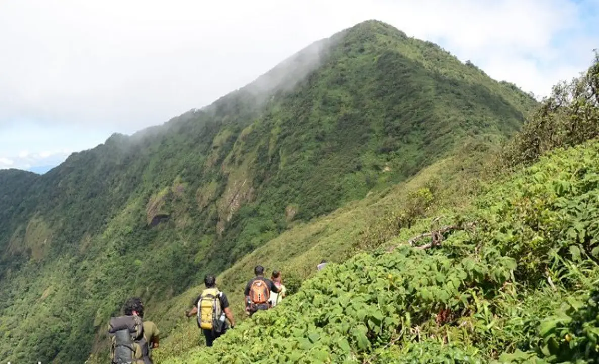
Khao Luang Peak in Nakhon Si Thammarat Province is the highest mountain in southern Thailand, rising to about 1,835 meters above sea level within Khao Luang National Park. For Thai hikers, nature lovers, and adventure travelers, reaching this peak is one of the classic long-distance trekking goals in the South. This is not a casual walking route. The standard trek takes about 3 days and 2 nights through humid evergreen forest, steep slopes, mud, roots, streams, leeches, rain, and fast-changing weather. The reward is standing on the green roof of southern Thailand, surrounded by cloud forest, mountain layers, watershed forest, and sunrise views that feel deeply connected to both wilderness and personal endurance.
Khao Luang Peak is part of Khao Luang National Park, a large protected forest area covering several districts of Nakhon Si Thammarat, including Lan Saka, Mueang Nakhon Si Thammarat, Chawang, Phipun, Phrom Khiri, Chang Klang, and Nopphitam. The park covers the central section of the Nakhon Si Thammarat mountain range, which runs north to south parallel to the eastern coastline. Its landscape is made up of high mountains, deep valleys, streams, waterfalls, cliffs, moist evergreen forest, and hill evergreen forest shaped by sea-driven monsoon rain. This moisture-rich environment gives Khao Luang its reputation as the green roof of the South.
The importance of Khao Luang is not only its elevation. The mountain forest is a major watershed for southern Thailand. Water from the range feeds several rivers and streams, including the Tapi River, Pak Phanang River, Khlong Krung Ching, Khlong Khao Kaeo, Khlong Tha Phae, Khlong Ranae, and Khlong La-ai. These water systems support communities, agriculture, waterfalls, and ecosystems across Nakhon Si Thammarat and nearby areas. Trekking to Khao Luang Peak is therefore also a journey into the heart of a watershed forest that sustains life far beyond the mountain itself.
The forest of Khao Luang is a humid evergreen rainforest that rarely experiences dryness or leaf fall. Monsoon winds from the sea bring moisture and rain throughout much of the year. Along the trekking route, hikers pass through dense green forest filled with large trees, ferns, mosses, epiphytes, wild orchids, and endemic plants. Some sections are thick and enclosed, with steep climbs, root-covered ground, wet soil, and mud. The route requires equipment suitable for a southern Thai rainforest, not the same preparation used for dry-season hiking in other regions.
One of the outstanding features of Khao Luang is its diversity of ferns and orchids. More than 200 fern species have been recorded in the area, including ancient-looking ferns such as Bua Chaek and large tree ferns known locally as Maha Sadam. The forest is also one of the important southern orchid habitats, with many species growing on the trunks and branches of trees in the humid forest. At higher elevations, visitors may encounter plants associated with the unique identity of Khao Luang, including Khao Luang rhododendron. These species make the mountain valuable not only for trekking but also for botany and ecological study.
The most popular approach to Khao Luang Peak begins around Ban Khiri Wong or nearby communities. Hikers must coordinate in advance with the national park, local guides, and porters. A standard itinerary takes 3 days and 2 nights. Participants carry personal gear and share group supplies according to the trip plan. Some parts of the route are steep and physically demanding, while others are muddy and slippery. Leeches are common in humid sections. Essential equipment includes suitable trekking shoes, quick-dry clothing, rain protection, a proper flysheet or rainproof sleeping system, leech socks, waterproof bags, a headlamp, and basic first aid supplies.
A typical Khao Luang trek is divided into 3 days. The first day leads hikers into the rainforest and toward the camp area, allowing the group to adjust to humidity, pack weight, and the rhythm of southern forest trekking. The second day usually focuses on the summit push and the main viewpoint or high area before returning to camp. The third day is the descent back toward the community. Descending can be as challenging as climbing because wet ground, tired legs, mud, and steep slopes increase the risk of slips and falls.
Camping areas on the route are limited and must follow park guidance. Many sites are small shoulder areas or designated forest camps. Hikers should not expand campsites, cut vegetation, light fires outside permitted areas, or leave rubbish behind. A strict low-impact ethic is essential on Khao Luang because high-elevation forest recovers slowly. Increasing visitor numbers can affect soil, ground cover, streams, and wildlife if trekking is not carefully managed.
The suitable trekking season depends on official park announcements. Tourism information identifies January to September as the better general period for long and short nature trails, while many trekkers prefer January to June for the Khao Luang summit route. However, rain can occur at any time in Khao Luang’s rainforest. Every group must check the latest park announcement before departure and accept that trips can be postponed or canceled if weather conditions become unsafe.
The sunrise from Khao Luang Peak is one of the experiences hikers hope for most. On a clear morning, light slowly spreads over the mountain forest, revealing layers of ridges, moving mist, and cloud forest below. It is a powerful reward after long hours of climbing, rain, cold, and fatigue. Still, the mountain never guarantees clear views. Clouds, fog, and rain may cover the summit even during the better season. Travelers should approach Khao Luang with respect for nature rather than only expecting the famous viewpoint photographs.
Ban Khiri Wong is an important base for Khao Luang trekking. The village is well known for its clean air, orchards, streams, local homestays, and strong relationship with the mountain forest. Many trekking groups use Khiri Wong as a preparation point before entering the forest, arranging supplies, guides, porters, and accommodation. Starting from Khiri Wong gives the trip a deeper meaning because it connects the mountain, water, community life, and local conservation practices.
Physical preparation is essential. Khao Luang requires leg strength, endurance, balance, and the ability to walk for long hours in wet forest conditions. Hikers should train with stair climbing, short hikes, light running, and weighted walking for several weeks before the trip. Anyone with a medical condition should assess their readiness honestly and inform the trip leader or park staff in advance. Pushing beyond one’s real condition can create risk not only for the individual but for the whole group.
Gear should focus on rain protection, waterproofing, and weight control. Backpacks should have rain covers or internal waterproof liners. Clothes should dry quickly; jeans and heavy cotton are unsuitable. Hikers should bring more than one pair of socks. Leech socks are highly recommended. A dry sleeping set should be packed separately in a waterproof bag. Sleeping gear must be truly rain-resistant, because night rain on Khao Luang can make an underprepared trip extremely difficult.
Food and water planning must be practical. High-energy, lightweight food is best, such as dry food, trail snacks, nuts, dried fruit, electrolyte drinks, and easy-to-cook meals based on the group plan. Water planning should be discussed with guides, including where natural water sources are available and whether filters or purification tablets are necessary. All food waste and packaging must be carried back down. Nothing should be left in this watershed forest.
The main risks of the route include rain, slippery slopes, flash-water conditions, cold caused by wet clothing, leeches, fatigue, injuries, and getting lost. For this reason, hikers should not attempt the route without park coordination or qualified local guidance. Southern rainforest trails can change after heavy rain, and navigation is not always obvious. Official guidance and local experience reduce risk and keep the trip better organized.
Although the peak is the main goal, Khao Luang National Park also includes many important attractions such as Karom Waterfall, Phrom Lok Waterfall, Ai Khiao Waterfall, Krung Ching Waterfall, and Kaeo Surakan Cave. Karom Waterfall is associated with the park headquarters and has several waterfall levels known locally as nan. Some areas are linked with royal visits by King Rama V and King Rama VI. Kaeo Surakan Cave is a limestone cave located before the park headquarters and contains stalactites and stalagmites. Travelers who are not ready for a long-distance trek can begin with these shorter nature attractions.
Getting There is easiest by private car or rental car. From Nakhon Si Thammarat City, travel toward Lan Saka District and Khao Kaeo Subdistrict for the park area or Ban Khiri Wong for trekking preparation. The road to Khiri Wong is accessible by normal vehicles and has local accommodation, restaurants, shops, and community tourism services. Trekking groups should arrive at least one day before starting the hike in order to check gear, coordinate guides and porters, divide supplies, and rest properly.
For trekking arrangements, older tourism information lists Ban Khiri Wong, Tarzan Adventure Tour, and the Ban Wang Lung Nature and Environment Conservation Club as contact points. Current trekkers should still confirm all details directly with Khao Luang National Park, because booking rules, group size, guide requirements, porter arrangements, fees, and trail opening periods may change according to season and official announcements. Long-distance rainforest trekking should never rely only on old information.
Overall, Khao Luang Peak is much more than the highest mountain in southern Thailand. It is a test of body, mind, and attitude toward nature. The route shows that rainforest is not just a green background but a living system that must be entered with respect. With proper preparation, official coordination, suitable timing, and responsible trekking behavior, Khao Luang offers more than a summit photograph. It teaches hikers about watershed forests, biodiversity, fragile ecosystems, and the personal meaning of moving beyond one’s limits.
| Name | Khao Luang Peak, Khao Luang National Park |
| Location | Khao Luang National Park, Nakhon Si Thammarat Province |
| Address | Khao Kaeo Subdistrict, Lan Saka District, Nakhon Si Thammarat 80230, Thailand |
| Coordinates | 8.504480, 99.735920 |
| Highlights | Highest peak in southern Thailand, about 1,835 meters above sea level, 3-day 2-night rainforest trek, cloud forest, ferns, orchids, Khao Luang rhododendron, and sunrise viewpoint |
| History / Importance | Major watershed forest of southern Thailand, giving rise to rivers and streams such as the Tapi River, Pak Phanang River, Khlong Krung Ching, Khlong Khao Kaeo, Khlong Tha Phae, Khlong Ranae, and Khlong La-ai |
| Distinctive Features | Complex mountain range, rain-rich evergreen forest, endemic plants, more than 200 fern species, southern orchids, and watershed rainforest ecosystem |
| Travel Information | From Nakhon Si Thammarat City, travel toward Lan Saka District and Ban Khiri Wong or the Khao Luang National Park area. Trekking groups should arrive one day in advance to coordinate guides, porters, supplies, and park requirements. |
| Current Status | Open according to the national park’s trekking schedule; no permanent closure found. Long-distance trekking requires advance coordination with park officers. |
| Open Days | Open according to the park schedule; tourism and overnight stays are closed from 1 October – 31 December |
| Opening Hours | 08.30 – 16.30 for visitor service areas and park contact |
| Fees | Thai adults 40 THB, Thai children 20 THB / foreign adults 200 THB, foreign children 100 THB. Trekking, guide, porter, and overnight fees should be confirmed directly with the park before travel. |
| Facilities | Park accommodation, camping areas, visitor service area, coordinated park guides, and Ban Khiri Wong community support for trekking preparation |
| Main Areas / Zones | Khao Luang Peak, long-distance trekking route, Ban Khiri Wong, Karom Waterfall, Phrom Lok Waterfall, Ai Khiao Waterfall, Krung Ching Waterfall, Kaeo Surakan Cave, and Khao Luang rainforest zone |
| Caretaker | Khao Luang National Park under the Department of National Parks, Wildlife and Plant Conservation |
| Main Contact Number | 075-300-494, 075-300-495, 075-300-439 |
| Trekking Contact | Ban Khiri Wong Tel. 075-533-113, 075-533-370 / Tarzan Adventure Tour Tel. 089-909-8533, 081-824-8880 / Ban Wang Lung Nature and Environment Conservation Club Tel. 087-885-9167 |
| Official Website / Official Page | Official Facebook page of Khao Luang National Park |
| Nearby Tourist Attractions | 1. Ban Khiri Wong, about 0 km 2. Nan Hin Tha Ha, Ban Khiri Wong, about 2 km 3. Wang Mai Pak Waterfall, about 3 km 4. Karom Waterfall, about 22 km 5. Phrom Lok Waterfall, about 36 km 6. Wat Phra Mahathat Woramahawihan, about 39 km |
| Nearby Restaurants | 1. Khiri Wong River View, about 1 km, Tel. 075-533-335, 082-222-3971-2 2. Ruean Phak Kut, Lan Saka, about 8 km 3. Krua Nai Nang Restaurant, about 10 km 4. Local Lan Saka Restaurant, about 12 km 5. Local Restaurants in Nakhon Si Thammarat City, about 38 km |
| Nearby Accommodations | 1. Ban Khiri Wong Homestay, about 0 km, Tel. 075-533-113 2. Tha Ha Resort, Ban Khiri Wong, about 2 km, Tel. 075-533-155 3. Khiri Wong River View, about 1 km, Tel. 075-533-335, 082-222-3971-2 4. Khiri Wong Community Accommodation, about 1 km, Tel. 075-533-370 5. Hotels in Nakhon Si Thammarat City, about 38 km |
Frequently Asked Questions (FAQ)
Q: Where is Khao Luang Peak located?
A: Khao Luang Peak is located inside Khao Luang National Park in Nakhon Si Thammarat Province. It is the highest peak in southern Thailand, rising to about 1,835 meters above sea level.
Q: How long does the Khao Luang trek take?
A: The standard trek takes about 3 days and 2 nights, with advance coordination required for park officers, guides, porters, and group arrangements.
Q: When is the best time to trek Khao Luang?
A: January to June is a popular period, while tourism information identifies January to September as suitable for trekking. Travelers must check the latest park announcement before departure.
Q: When is Khao Luang trekking closed?
A: Tourism and overnight stays in the national park are closed from 1 October to 31 December according to tourism information for the park.
Q: Is a guide required for Khao Luang?
A: Yes. Long-distance trekking should be coordinated with park staff or qualified local guides because the route passes through humid rainforest with steep, muddy, slippery, and weather-sensitive sections.
Q: What should hikers prepare for Khao Luang?
A: Hikers should prepare suitable shoes for mud and slippery ground, rainwear, a rainproof sleeping system, leech socks, quick-dry clothing, waterproof bags, a headlamp, personal medicine, high-energy food, and rubbish bags.
Q: Can first-time hikers do Khao Luang?
A: First-time hikers should train seriously and try shorter trails first. Khao Luang is a demanding multi-day rainforest route with humidity, rain, steep climbs, leeches, and accumulated fatigue.
Q: What nearby attractions can visitors combine with Khao Luang?
A: Nearby attractions include Ban Khiri Wong, Nan Hin Tha Ha, Wang Mai Pak Waterfall, Karom Waterfall, Phrom Lok Waterfall, Ai Khiao Waterfall, Krung Ching Waterfall, and Kaeo Surakan Cave.
 Category: ●Nature and Wildlife
 Group: ●Mountain (Doi)
Last Update : 3 MonthAgo
 Last Update : 3 MonthAgo
 Click to Access the Navigation Map GPS
Khao Luang Peak Map
Recommend

 Art, Culture and Heritage
 Historical Sites and Monuments(9)
 Landmarks and Memorials(9)
 Royal Palace(1)
 Art, Craft Centres, Tradition(12)
 Museums(5)
 Educational Places
 Educational Gardens, Farm(2)
 University
 Public university(1)
 Autonomous Universities(3)
 Rajamangala University of Technology(2)
 Rajabhat University(1)
 Private University(1)
 Places of Worship
 Temple(45)
 Mosque(2)
 Other Sacred Sites(17)
 Research and Development
 Royal Project(2)
 Suburban Living
 Village, Community(8)
 Local Market(1)
 Floating Market(1)
 National Parks and Marine Reserves(6)
Mountain (Doi)(11)
 Dam, Reservoir, Lake(10)
 Waterfalls(43)
 Hot Springs(1)
 Caves(13)
 River, Canal(3)
 Bays and Beaches(29)
 Islands(2)
 Other natural attractions(3)
 Entertainment and Agricultural
 Farms, Parks and Ecotourism(3)
 Outdoor and Adventure Activities(4)
 Shopping
 Department Store(1)
 Travel Articles, Recipes
 Travel Review, Food Review(6)
 Southern Food Menu, Southern Food Recipes(18)


