
lovethailand home >Northeastern Travel Attractions >Ubon Ratchathani Travel Attractions >Na Cha Luai >Na Cha Luai > Huai Luang Waterfall
TL;DR: Huai Luang Waterfall is located at Phu Chong Na Yoi National Park, Na Chaluai Subdistrict, Na Chaluai District, Ubon Ratchathani Province, open Daily, hours 08.30 – 16.30.

Huai Luang Waterfall
Open Days: Daily
Opening Hours: 08.30 – 16.30
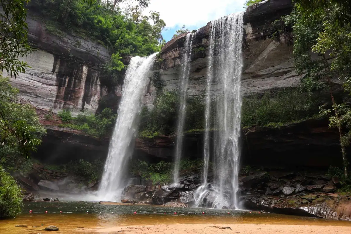
Huai Luang Waterfall, also known locally as Tham Bak Teo Waterfall, is the signature waterfall of Phu Chong Na Yoi National Park in Na Chaluai District, Ubon Ratchathani Province. It is one of the most impressive waterfalls in lower northeastern Thailand, formed by Huai Luang stream plunging from a high sandstone cliff into a large pool below. The waterfall drops about 45 meters, creating a powerful curtain of water, cool mist, an emerald-colored basin, and a distinctive white sandy area at the base. This combination of height, forest, cliff, sand, and water makes Huai Luang Waterfall one of the most memorable natural attractions in Ubon Ratchathani.
The waterfall is located inside Phu Chong Na Yoi National Park, a protected forest area in the Phanom Dong Rak mountain range near the borderlands of Thailand, Laos, and Cambodia. The park covers parts of Buntharik, Na Chaluai, and Nam Yuen districts and is known for its fertile forest, mountain streams, sandstone formations, seasonal flowers, campsites, and several natural attractions. Huai Luang Waterfall is the main highlight of the park because it is accessible by road, visually dramatic, and suitable for both sightseeing and nature-based travel.
The most striking feature of Huai Luang Waterfall is the view of water falling from a tall cliff into the large basin below. From the upper viewpoint, visitors can see the waterfall framed by forest and rock. From the lower pool, the scale becomes much more powerful. Looking up from the base, the cliff feels high and dramatic, and the water appears to fall directly from the forested edge of the mountain into the emerald pool. This lower viewpoint is the best place to understand why the waterfall is considered one of the most beautiful waterfalls in southern Isan.
To reach the base of the waterfall, visitors descend a long staircase of 272 steps from the visitor-service area. This descent is an important part of the experience. As visitors walk down, the sound of the waterfall becomes louder, the air becomes cooler and more humid, and the forest begins to surround the path. The way down is easier than the return climb, so visitors should allow enough time and energy for the walk back up. The staircase makes the waterfall accessible, but it still requires reasonable physical readiness.
At the base, the waterfall opens into a large natural pool with greenish water and a clean white sandy edge. The sandy area is one of the most distinctive features of Huai Luang Waterfall. It gives the place a rare atmosphere: a beach-like setting hidden deep within a forested waterfall basin. The water, sand, rocks, cliff, and forest canopy create a landscape that feels both powerful and peaceful. This is one reason why the waterfall appeals to photographers, families, nature travelers, and international visitors.
The older local name, Tham Bak Teo Waterfall, is connected with local stories about a cave beneath the cliff and a man named Teo who entered the forest in the past to collect wild honey. The name is still widely known among local people and appears together with the official name Huai Luang Waterfall. These two names give the place both natural and cultural meaning. Huai Luang refers to the stream that creates the waterfall, while Tham Bak Teo preserves local memory linked with the cliff, cave, bees, forest use, and village storytelling.
Huai Luang Waterfall is most attractive from the rainy season into the cool season. The best general period is from August to February, with strong water flow often seen from September to November. During the rainy season, the waterfall becomes powerful and fresh, and the surrounding forest is at its greenest. In the cool season, the water remains attractive, the weather is more comfortable, and the park becomes suitable for camping and longer nature trips. In drier periods, the water may decrease, but the cliff, pool, sand, and forest setting remain visually interesting.
Safety is important at a large waterfall like Huai Luang. Visitors should swim only in designated areas and stay within the floating safety boundary set by the park. The pool is large and beautiful, but depth and current can vary by season. Children, elderly visitors, and weaker swimmers need close supervision. Visitors should not approach the strong impact zone directly under the falling water, climb wet rocks, or enter restricted areas. After heavy rain, extra caution is required because water levels can rise quickly.
The waterfall area has useful visitor facilities. There are parking areas, a visitor-service point, toilets, restaurants near the upper access zone, viewpoints, the staircase down to the waterfall, national park accommodation, and camping areas. These facilities make Huai Luang suitable for day trips as well as overnight stays. Visitors who plan to camp or stay in park accommodation should contact the park in advance, especially during holidays or the cool season.
Food services are available near the waterfall access area during visitor periods, and more restaurants can be found in Na Chaluai town. Since the descent and return climb take energy, visitors should drink water before going down and carry essential items carefully. Litter should always be taken back out. The sandy area and pool at the base of the waterfall are fragile and should be kept clean.
For photographers, Huai Luang Waterfall offers several strong compositions. The upper viewpoint captures the full waterfall and forest setting. The lower area gives dramatic views of the cliff, water curtain, emerald pool, white sand, and mist. Morning and early afternoon are usually comfortable for photography. During stronger flow, water spray can reach camera equipment, so waterproof protection and lens cloths are useful.
Geographically, the waterfall is a clear example of a mountain stream changing level across a sandstone cliff. Huai Luang stream flows through the forest before dropping sharply into the basin below. Over time, falling water has helped shape the pool, move sediment, and create the sandy area at the base. The site therefore allows visitors to see how water, rock, gravity, forest, and time work together to create a major natural landmark.
The surrounding national park adds depth to the trip. Kaeng Kalao is a stream-and-rock area on Huai Luang stream, suitable for relaxing and nature observation. Kaeng Sila Thip is known for natural potholes created by water erosion on sandstone. Phlan Kong Kwian offers wide rock plains, natural stone shelters, and seasonal plants. Phu Hin Dang is a more adventurous area with unusual sandstone formations and viewpoints, requiring advance contact with park staff. Visiting these places together with Huai Luang Waterfall gives a broader understanding of Phu Chong Na Yoi National Park.
Another nearby waterfall is Pra-on La-or Waterfall, also known as Chum Chim Waterfall, located along the stream beyond Huai Luang Waterfall. It is smaller but attractive and helps visitors understand the downstream character of Huai Luang stream after the main waterfall. Access should follow safe conditions and park guidance. When combined with the main waterfall, it adds a quieter and more detailed nature experience.
Phu Chong Na Yoi National Park is also a good place for camping and overnight nature travel. The park accommodation and camping area are located around the headquarters zone before the waterfall. Staying overnight allows visitors to explore the waterfall without rushing and to include nearby attractions such as Kaeng Kalao, Kaeng Sila Thip, Phlan Kong Kwian, and other forest routes. The cool season is especially suitable for camping because the weather is more comfortable.
Getting There from Ubon Ratchathani city usually follows the route toward Det Udom, Nam Yuen, and Na Chaluai. From Na Chaluai, continue on Highway 2248 and turn into Rural Road UB 4057 toward Phu Chong Na Yoi National Park. The total distance from Ubon Ratchathani city is about 140 km. After reaching the national park headquarters, drive about 3.4 km farther to the waterfall area. A private car or rental car is the most convenient option.
The road into the national park is generally suitable for ordinary vehicles, but travelers should check fuel, weather, and timing before entering the forest route. Since this is a mountain and border-area national park, daytime travel is recommended. Visitors planning to swim, camp, or photograph the waterfall should arrive early enough to have time for the descent, rest, and return climb.
Travelers without a private vehicle can first travel to Na Chaluai District, then arrange local transport or hire a vehicle to the national park. This requires planning because public transport directly to the waterfall is limited. Hiring local transport is useful for groups that want to visit several attractions inside the park in one day.
A one-day trip from Ubon Ratchathani city is possible but should start early. Huai Luang Waterfall should be the main destination of the day because the distance is significant and the 272-step descent and return climb require time. A practical plan is to leave the city in the morning, reach the park before midday, visit the waterfall in the afternoon, and return before dark.
A two-day trip gives a better experience. On the first day, travelers can enter the park, check in at accommodation or a campsite, and visit Kaeng Kalao, Phlan Kong Kwian, or Kaeng Sila Thip. On the second day, they can spend more time at Huai Luang Waterfall, descend to the lower pool, take photographs, relax, and travel back without rushing. This plan gives a fuller understanding of the park.
Huai Luang Waterfall is suitable for families, but visitors should evaluate the physical ability of everyone in the group before descending to the lower pool. The upper viewpoint can be enjoyed without going all the way down. Families with children should supervise them closely on stairs, near the water, and around wet rocks. The best family experience comes from moving slowly and allowing enough rest time.
For international travelers, Huai Luang Waterfall shows a side of northeastern Thailand that differs from the Mekong River, temples, and city attractions. It reveals the forested mountains of Ubon Ratchathani, the borderland landscape of the Phanom Dong Rak range, and a large waterfall hidden within a protected national park. It is a strong destination for travelers who want to see the natural depth of Isan.
Responsible travel is essential. Visitors should not leave rubbish, use soap or chemicals in the water, write on rocks, disturb plants, feed wildlife, or ignore park instructions. The pool, white sand, forest stream, and cliff environment are all part of a protected ecosystem. Keeping the area clean helps preserve the waterfall for both local communities and future visitors.
Overall, Huai Luang Waterfall is one of the most rewarding natural attractions in Ubon Ratchathani. It offers a dramatic cliff waterfall, an emerald pool, white sand, forest atmosphere, viewpoints, swimming areas, park facilities, camping options, and nearby nature sites in the same protected landscape. With proper timing, good preparation, and respect for park rules, the waterfall provides a powerful and memorable experience in lower northeastern Thailand.
| Name | Huai Luang Waterfall / Tham Bak Teo Waterfall |
| Location | Phu Chong Na Yoi National Park, Na Chaluai Subdistrict, Na Chaluai District, Ubon Ratchathani Province |
| Address | Phu Chong Na Yoi National Park area, Ban Kaeng Rueang, Na Chaluai Subdistrict, Na Chaluai District, Ubon Ratchathani 34280 |
| Coordinates / Navigation Point | Huai Luang Waterfall, Phu Chong Na Yoi National Park, Na Chaluai District, Ubon Ratchathani; access via Highway 2248 and Rural Road UB 4057 toward the national park headquarters and waterfall area |
| Distinctive Features | A large waterfall formed by Huai Luang stream dropping about 45 meters from a cliff into an emerald pool, with a white sandy base, upper viewpoint, and 272-step staircase to the lower basin |
| Name Origin | The name Huai Luang comes from the stream that forms the waterfall. The local name Tham Bak Teo is connected with a cave beneath the cliff and a local story about a man named Teo who entered the forest to collect wild honey. |
| Natural Formation | A mountain-stream waterfall in the Phanom Dong Rak range, with sandstone cliffs, a large plunge pool, white sand, dry evergreen forest, mixed deciduous forest, dry dipterocarp forest, streams, and nearby rock formations |
| Travel Information | From Ubon Ratchathani city, travel toward Det Udom, Nam Yuen, and Na Chaluai, then continue on Highway 2248 and Rural Road UB 4057 to Phu Chong Na Yoi National Park. The total distance is about 140 km. From the park headquarters, the waterfall is about 3.4 km away. |
| Current Status | Open as the main waterfall attraction of Phu Chong Na Yoi National Park. The 2026 annual closure list does not include Huai Luang Waterfall. |
| Open Days | Daily |
| Opening Hours | 08.30 – 16.30 |
| Fees | Thai visitors: Adult 40 Baht, Child 20 Baht Foreign visitors: Adult 200 Baht, Child 100 Baht Car: 30 Baht per vehicle Motorcycle: 20 Baht per vehicle Camping area fee: 30 Baht per person per night |
| Facilities | Parking area, visitor-service center, viewpoint, 272-step staircase, toilets, restaurants near the waterfall access area, national park accommodation, camping area, and basic park services |
| Main Areas / Zones | Parking And Restaurant Zone Visitor-Service Zone Upper Waterfall Viewpoint Zone 272-Step Staircase Zone Emerald Pool Zone White Sand Base Zone Stream And Pra-on La-or Waterfall Zone National Park Accommodation And Camping Zone |
| Caretaker | Phu Chong Na Yoi National Park, Department of National Parks, Wildlife and Plant Conservation |
| Main Contact Number | Phu Chong Na Yoi National Park, Tel. 0 4521 0706, 064-232-5741 |
| Best Time To Visit | August to February for general waterfall travel; September to November for strong water flow; the cool season for camping and nearby nature routes |
| Safety Notes | The 272-step staircase requires physical effort. Be careful of slippery surfaces after rain, swim only within the floating boundary, avoid the strong waterfall impact zone, and follow national park staff instructions. |
| Nearby Tourist Attractions | 1. Pra-on La-or Waterfall / Chum Chim Waterfall, 1 km, Tel. 0 4521 0706, 064-232-5741 2. Kaeng Kalao, 3 km, Tel. 0 4521 0706, 064-232-5741 3. Kaeng Sila Thip, 4 km, Tel. 0 4521 0706, 064-232-5741 4. Phlan Kong Kwian, 5 km, Tel. 0 4521 0706, 064-232-5741 5. Phu Chong Na Yoi National Park Headquarters And Camping Area, 3 km, Tel. 0 4521 0706, 064-232-5741 6. Phlan Yao Stone Garden, 25 km, Tel. 0 4521 0706, 064-232-5741 7. Pha Phueng Viewpoint, 26 km, Tel. 0 4521 0706, 064-232-5741 8. Phu Hin Dang, 40 km, Tel. 0 4521 0706, 064-232-5741 |
| Nearby Restaurants | 1. Chok Amnuai Restaurant, Na Chaluai, 20 km, Tel. 045-379128 2. Sai Ngam Restaurant, Na Chaluai, 20 km, Tel. 045-379029 3. Mon Chu Rot Restaurant, Na Chaluai, 20 km, Tel. 045-379134 4. Mae Ke Restaurant, Na Chaluai, 21 km, Tel. 045-379038 5. Huai Lok Restaurant, Na Chaluai, 21 km, Tel. 081-2661450 6. Thong Phun Barbecue, Na Chaluai, 20 km, Tel. 087-450-5729, 089-578-6924 7. Yufa Café Na Chaluai, 20 km, Tel. 099-391-6035 |
| Nearby Accommodations | 1. Phu Chong Na Yoi National Park Accommodation And Camping Area, 3 km, Tel. 0 4521 0706, 064-232-5741 2. Huai Luang Country Resort, Ban Kaeng Rueang, 5 km, Tel. 085-302-9342, 089-936-9272 3. Boontharika Hotel, Na Chaluai, 20 km, Tel. 085-413-1417 4. Aronnarin Resort, Na Chaluai, 20 km, Tel. 045-409-074, 084-355-3370 5. Huai Lok Riverside Resort, Na Chaluai, 23 km, Tel. 087-993-1859 6. Ing Fah Huan Resort, Na Chaluai, 24 km, Tel. 045-841-618 |
Frequently Asked Questions (FAQ)
Q: Where is Huai Luang Waterfall located?
A: Huai Luang Waterfall is located inside Phu Chong Na Yoi National Park in Na Chaluai District, Ubon Ratchathani Province, about 3.4 km from the national park headquarters.
Q: What are the opening days and hours?
A: Huai Luang Waterfall is open daily from 08.30 to 16.30.
Q: Is there an entrance fee?
A: Yes. The national park entrance fee is 40 Baht for Thai adults, 20 Baht for Thai children, 200 Baht for foreign adults, and 100 Baht for foreign children. Vehicle fees also apply by vehicle type.
Q: What are the main highlights of Huai Luang Waterfall?
A: The highlights are the 45-meter cliff waterfall, emerald pool, white sandy base, upper viewpoint, forest atmosphere, and 272-step staircase leading to the lower basin.
Q: How many steps lead down to the lower pool?
A: There are 272 steps from the upper visitor area down to the lower pool and sandy area. Shoes with good grip are recommended.
Q: When is the best time to visit Huai Luang Waterfall?
A: August to February is the best general period. September to November is good for strong waterfall flow, while the cool season is suitable for camping and nearby nature routes.
Q: Can visitors swim at Huai Luang Waterfall?
A: Visitors can swim only in the designated area and must stay within the floating boundary. Children and weak swimmers should be supervised closely.
Q: What attractions can be visited together with Huai Luang Waterfall?
A: Nearby attractions include Pra-on La-or Waterfall, Kaeng Kalao, Kaeng Sila Thip, Phlan Kong Kwian, Phlan Yao Stone Garden, Pha Phueng Viewpoint, and Phu Hin Dang.
 Category: ●Nature and Wildlife
 Group: ●Waterfalls
Last Update : 3 MonthAgo
 Last Update : 3 MonthAgo
 Click to Access the Navigation Map GPS
Huai Luang Waterfall Map
Recommend

 Art, Culture and Heritage
 Historical Sites and Monuments(5)
 Landmarks and Memorials(2)
 Royal Palace(1)
 Art, Craft Centres, Tradition(7)
 Museums(3)
 Places of Worship
 Temple(37)
 Other Sacred Sites(4)
 Research and Development
 Royal Project(2)
 Suburban Living
 Village, Community(2)
 Local Market(4)
 National Parks and Marine Reserves(5)
 Mountain (Doi)(6)
 Dam, Reservoir, Lake(8)
Waterfalls(12)
Dam, Reservoir, Lake(8)
Waterfalls(12)
 Hot Springs(1)
 Caves(2)
 River, Canal(11)
 Bays and Beaches(8)
 Islands(2)
 Other natural attractions(6)
 Entertainment and Agricultural
 Zoos and Aquariums(2)
 Animal camps and shows(1)
 Farms, Parks and Ecotourism(1)
 Waterpark(1)
 Travel Articles, Recipes
 Travel Review, Food Review(1)


