
lovethailand home >Northeastern Travel Attractions >Si Sa Ket Travel Attractions >Kan Thora Rak >Bueng Ma Lu > Prasat Don Tuan
TL;DR: Prasat Don Tuan is located at Ban Phumisrol, Bueng Malu Subdistrict, Kantharalak District, Si Sa Ket Province, open Daily When There Is No Government Closure Notice For The Border Area, hours 08.30 – 16.30.
Prasat Don Tuan
Open Days: Daily When There Is No Government Closure Notice For The Border Area
Opening Hours: 08.30 – 16.30
Prasat Don Tuan in Si Sa Ket is a small ancient Khmer sanctuary located at Ban Phumisrol, Bueng Malu Subdistrict, Kantharalak District, Si Sa Ket Province, close to the Thai–Cambodian border on the Dangrek Mountains. The temple lies along the same general route that connects Kantharalak with Pha Mo E Daeng, one of the best-known cliff viewpoints in Khao Phra Wihan National Park. Although Prasat Don Tuan is much smaller than the famous cliff-top temples of the region, it is a valuable cultural site because it combines Khmer architecture, local legend, border geography, forest atmosphere, and the quiet character of a lesser-known historical ruin.
The temple is set about 8 kilometers from Ban Phumisrol village and approximately 38 kilometers from Kantharalak town. A paved road leads toward the site, and parking is available near the ruin when the area is open to visitors. The approach already gives travelers a sense of the landscape that shaped this ancient monument: the road moves toward the Dangrek range, where forested ridges, sandstone formations, and border terrain define the character of southern Isan. For foreign travelers, this location is important because it shows that Khmer cultural heritage in Thailand is not limited to large monuments; smaller sanctuaries such as Prasat Don Tuan also help explain the historical network of temples around the Thai-Cambodian frontier.
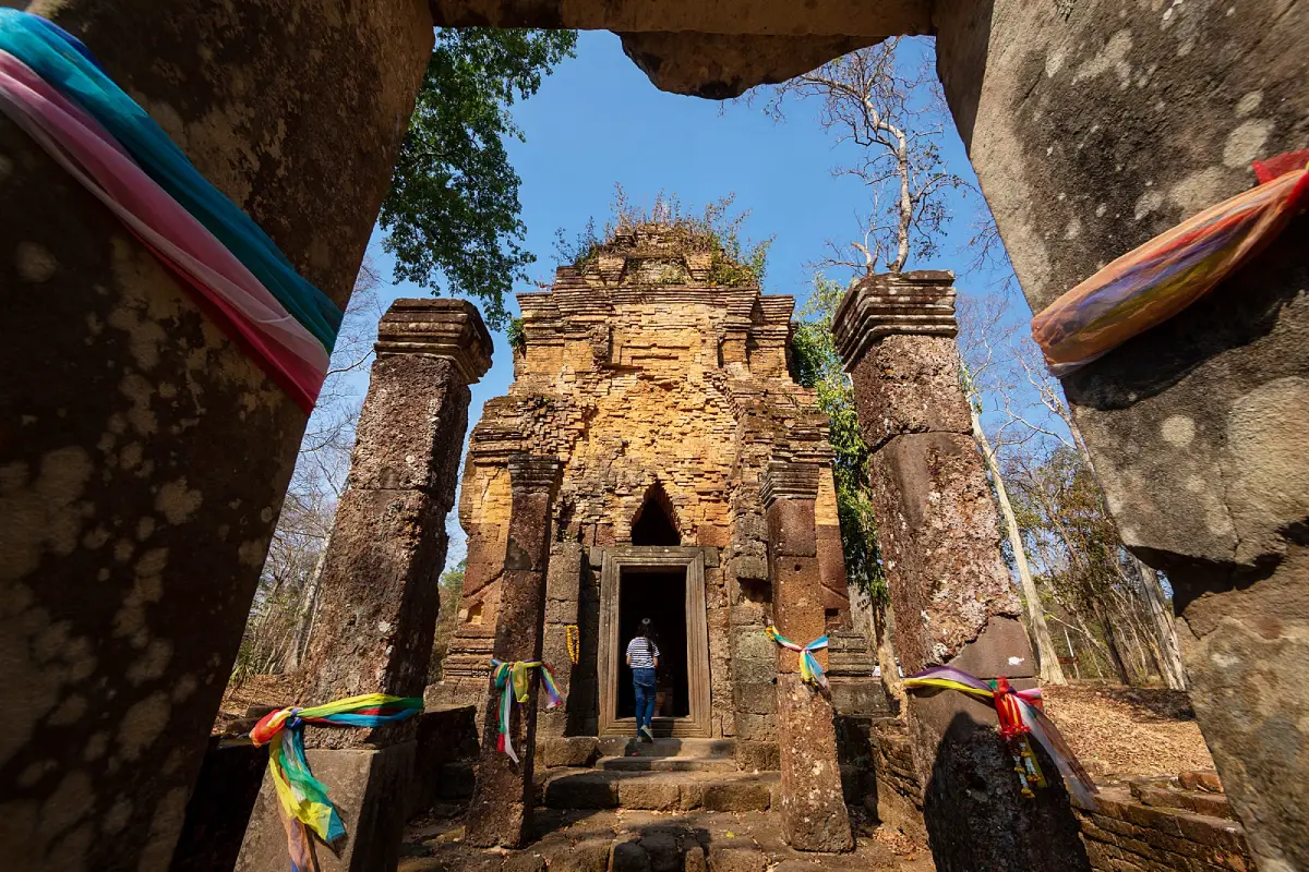
Prasat Don Tuan stands in a peaceful wooded area near a high cliff. Its atmosphere is very different from crowded heritage parks. The site feels quiet, shaded, and intimate, allowing visitors to observe the structure at close range. The most recognizable view is the brick sanctuary tower framed by sandstone pillars at the front. A carved lion figure is also associated with the front area of the temple, adding to the sense that this was once a carefully arranged sacred space rather than a simple isolated ruin. The setting makes the temple especially appealing to travelers interested in archaeology, cultural landscapes, and off-the-main-route historical places.
The main sanctuary is a single prang with a square plan measuring roughly 7 meters on each side. It has indented corners on all four sides and faces east, a common orientation in Khmer religious architecture. The eastern orientation is significant because it aligns the entrance with sunrise, beginnings, and ritual meaning. The lower section of the sanctuary is built with laterite, while the upper section is built with smooth brick. Sandstone appears in the doorway and pillars, showing how different materials were used for different architectural functions. Laterite provides strength at the base, brick forms the tower mass, and sandstone is used where stronger framed elements and carved details were needed.
The doorway is built with stone, giving the front of the sanctuary a strong architectural focus. In front of the sanctuary door are four sandstone pillars that formed part of the entrance area, while another group of sandstone pillars farther outward marks the broader gateway zone. These elements indicate that the temple originally had more than just a tower; it had an organized approach and ceremonial threshold. To the southeast of the sanctuary, sandstone blocks laid out in a rectangular pattern form the area of a library or associated structure. These components allow visitors to understand the temple as a small but complete sacred complex.
An ancient pond lies about 400 meters from the temple. Water features are important in Khmer sacred landscapes because water relates to ritual purity, symbolic order, and the organization of temple grounds. At Prasat Don Tuan, the pond confirms that the sanctuary was part of a larger religious setting. The main tower, entrance pillars, gateway zone, library area, pond, and cliff-side environment should be read together. This combined reading gives the site more depth than its small size first suggests.
Prasat Don Tuan dates to around the 10th–11th centuries CE, corresponding to approximately the 15th–16th Buddhist centuries in Thai historical dating. Local sources also connect the inscription on the doorframe with the year 1545 BE, placing the monument within the broader Khmer cultural period of the Dangrek Mountains. This was the same wider region in which major sanctuaries such as Preah Vihear were developed. Prasat Don Tuan therefore helps reveal the network of smaller religious sites that surrounded the great monuments and supported the cultural landscape of the border highlands.
Architecturally, the temple is an excellent example of a small single-tower Khmer sanctuary. It preserves the essential components needed to understand the structure: the main prang, the eastern entrance, the stone doorway, the front pillars, the gateway area, the associated library zone, and the pond. Unlike large temple complexes that overwhelm visitors with scale, Prasat Don Tuan invites careful observation of details. Travelers can clearly see where laterite ends and brick begins, how sandstone frames the entrance, and how the approach leads the eye toward the sanctuary chamber.
The local legend of Prasat Don Tuan gives the ruin another layer of meaning. According to the story, a noblewoman of great beauty had unusually large breasts and had to support them with a golden chain. When a Khmer king heard of her reputation, he ordered officials to bring her to court. During the journey, the group rested at the stone ground of Don Tuan. A man named Ta Leng, who came from the same village, followed her and tried to take her back. A fight broke out, and Ta Leng was killed. His body was left in the forest around the place where the temple now stands. This legend continues to connect the ruin with local memory and oral tradition.
The story should be understood as part of local cultural heritage rather than as a formal historical record. It helps explain how the community gives meaning to the place. The name Don Tuan is therefore more than a map label; it carries a remembered landscape, a local tale, and a relationship between the ruin and Ban Phumisrol. For travelers, listening to the legend enriches the visit because the temple becomes not only a Khmer architectural site but also a living cultural place within the local imagination.
Inside the sanctuary, a Buddha image is present for worship. This shows how an ancient Khmer sacred structure continues to function as a place of reverence in the present. Such continuity is common in Thailand, where old Hindu or Khmer sites may later receive Buddhist devotional use. Visitors should dress respectfully, keep their voices low, avoid climbing on the ancient structure, and never move stones or touch fragile surfaces unnecessarily. The brick, laterite, and sandstone have survived for centuries, and responsible behavior is essential to keeping the monument intact.
The atmosphere of Prasat Don Tuan is one of its strongest qualities. The ruin is surrounded by trees, and the cliff-side highland location gives the site a feeling of isolation and age. This is not a place designed for fast sightseeing. It is better experienced slowly, with attention to materials, layout, and setting. Travelers should notice the square plan of the tower, the indented corners, the eastern doorway, the stone pillars, the carved lion, the remains of the library area, and the way the forest frames the entire ruin.
The Dangrek Mountains form the natural backbone of this landscape. For centuries, the mountain range shaped movement, settlement, religious geography, and border identity between the Khorat Plateau and the plains to the south. The location of Prasat Don Tuan near this mountain edge is therefore meaningful. Many Khmer sanctuaries in southern Isan were built near natural routes, water sources, and elevated terrain. Even though Prasat Don Tuan is small, it helps complete the larger picture of Khmer cultural presence along the Thai-Cambodian border.
Because of its proximity to Pha Mo E Daeng, Prasat Don Tuan can be part of a historical and nature-based route in Kantharalak when official access conditions allow. A typical plan begins in Kantharalak town, continues toward Ban Phumisrol, stops at Prasat Don Tuan, and then connects with nearby border viewpoints and national park attractions when those areas are open. Travelers should allow enough time for mountain roads, local stops, and unhurried observation of the ruin. This is especially important for visitors interested in photography, archaeology, or cultural interpretation.
From Si Sa Ket city, travelers can drive toward Kantharalak District and continue along the Kantharalak–Pha Mo E Daeng route. Near kilometer 98 on Highway 2243, a side road leads approximately 4 kilometers toward Prasat Don Tuan. From Bangkok, the usual driving route passes through Saraburi, Nakhon Ratchasima, Highway 24, and the southern Isan corridor before reaching Kantharalak. From Ubon Ratchathani, travelers can also reach Kantharalak by road, making the site possible to include in a Si Sa Ket–Ubon Ratchathani itinerary.
Getting There is most convenient by private car or rental car. Public transport requires connections within Kantharalak and is less practical for travelers who want to visit multiple border-area attractions on the same day. Before traveling, check the current access status of the border road and nearby Pha Mo E Daeng area. Although no permanent closure notice for Prasat Don Tuan has been found, the nearby border zone can be affected by official restrictions. Visitors should follow announcements from Khao Phra Wihan National Park, Si Sa Ket authorities, and security agencies.
Prasat Don Tuan does not normally charge an admission fee. The visit usually takes about 30–60 minutes, depending on how closely travelers want to examine the remains. Morning and late afternoon are the best times for photography because the light is softer and brings out the color of the brick, laterite, and sandstone. After rain, the surrounding greenery can make the ruin especially photogenic, but visitors should walk carefully because natural surfaces around old ruins may become slippery.
The educational value of Prasat Don Tuan is strong. Students, families, and cultural travelers can use the site to understand ancient building materials, Khmer temple orientation, single-tower sanctuary planning, the role of water in sacred space, and the relationship between architecture and landscape. Seeing the site in person makes these ideas easier to understand than reading about them abstractly. The temple shows how even a small structure can express religious order, craftsmanship, and historical connection.
For photographers, the best views include the front perspective through the sandstone pillars, the diagonal view showing the indented tower corners, the close-up contrast between laterite and brick, and wider views that include the trees around the ruin. Visitors should never climb onto the structure for photographs. The best images come from respecting the monument and using natural angles from the ground. A quiet, careful approach also preserves the mood of the place for other visitors.
The site is also connected with local ritual life. Ceremonial offerings and community events have been organized at Prasat Don Tuan to honor local sacred beliefs, preserve cultural traditions, and promote awareness of the heritage site. This shows that the ruin is not only an archaeological object. It remains part of community identity. For foreign travelers, this is an important point: old monuments in Thailand often continue to carry living meaning for local people, even when their original religious context has changed.
Compared with Preah Vihear, which is famous internationally and carries complex border history, Prasat Don Tuan is smaller, quieter, and more local. Its strength lies in accessibility of detail. Visitors can stand close enough to observe the materials, doorway, pillars, and tower form without being overwhelmed by scale. This makes the site a valuable stop for anyone who wants to understand the broader Khmer heritage of southern Isan beyond only the most famous monuments.
Prasat Don Tuan also helps tell the story of Si Sa Ket as a province rich in Khmer heritage. Si Sa Ket is not only a destination for temples, waterfalls, and local food; it also contains archaeological sites that reveal the layered history of the region. Ban Phumisrol, Kantharalak, the Dangrek Mountains, Pha Mo E Daeng, and the wider Khao Phra Wihan landscape all form a cultural corridor where history, geography, and local identity meet. Including Prasat Don Tuan in a travel plan gives visitors a deeper view of this part of Thailand.
Preparation for a visit should include drinking water, comfortable shoes, sun protection, and rain protection during the rainy season. The site is small but located in a natural highland setting, so visitors should keep the area clean, avoid loud behavior, and protect the ancient masonry. No stones, bricks, or objects should be removed from the site. A respectful visit means allowing the ruin to remain as it is while taking time to understand its architecture and cultural context.
In summary, Prasat Don Tuan is a small Khmer ruin with significance greater than its physical size. It preserves a single sanctuary tower, a stone doorway, front pillars, a gateway zone, a library area, an ancient pond, a carved lion, and a local legend linked to Ban Phumisrol. Its location on the Dangrek Mountains near the Thai-Cambodian border gives it a distinctive atmosphere. For travelers seeking a quieter and more detailed cultural experience in Si Sa Ket, Prasat Don Tuan is an important heritage stop when border-area access is officially open.
| Name | Prasat Don Tuan |
| Location | Ban Phumisrol, Bueng Malu Subdistrict, Kantharalak District, Si Sa Ket Province |
| Address | Ban Phumisrol, Bueng Malu Subdistrict, Kantharalak District, Si Sa Ket 33110, near the Kantharalak–Pha Mo E Daeng route |
| Highlights | A small ancient Khmer sanctuary on a high cliff of the Dangrek Mountains, featuring a brick and laterite prang, stone doorway, sandstone pillars, and a carved lion figure in front of the temple |
| History | Built around the 15th–16th Buddhist centuries, with inscription evidence on the doorway and historical links to Khmer cultural heritage along the Dangrek Mountains |
| Name Origin | The name Don Tuan is linked to a local legend about a noblewoman, Ta Leng, and events remembered around the stone ground and forest near the temple |
| Distinctive Features | A single square-plan sanctuary about 7 meters on each side, with indented corners on all four sides, facing east. The lower half is built with laterite, the upper half with brick, and the doorway is built with stone |
| Travel Information | From Kantharalak, follow the Kantharalak–Pha Mo E Daeng route and turn off Highway 2243 near kilometer 98 for about 4 km. The temple is about 8 km from Ban Phumisrol and about 38 km from Kantharalak town |
| Current Status | No permanent closure notice has been found for Prasat Don Tuan. Travel on the nearby border route must follow official opening and closure announcements before departure |
| Open Days | Daily when there is no government closure notice for the border area |
| Opening Hours | 08.30 – 16.30 |
| Fees | No admission fee |
| Facilities | Paved access road, parking area near the temple, and walking space around the ruin |
| Main Areas / Zones | Main sanctuary, stone doorway, front sandstone pillars, gateway zone, southeastern library area, carved lion figure, ancient pond about 400 meters from the temple, stone ground, and cliff-side forest area |
| Caretaker | The area is associated with Khao Phra Wihan National Park and local authorities around Ban Phumisrol. The Don Tuan ritual ceremony has been organized by Sao Thong Chai Subdistrict Administrative Organization |
| Main Contact Number | Sao Thong Chai Subdistrict Administrative Organization, Tel. 045-924829 / TAT Surin Office, Tel. 044-514447 |
| Official Website / Official Page | https://kantharalak.go.th/ and https://calendar.m-culture.go.th/ |
| Nearby Tourist Attractions | 1. Pha Mo E Daeng, about 10 km 2. Pha Mo E Daeng Low-Relief Carvings, about 10 km 3. Khao Phra Wihan National Park, about 10 km 4. Sra Traw, about 12 km 5. Huai Khanun Reservoir, about 25 km 6. Wat Pa Maha Chedi Kaew, about 75 km |
| Nearby Restaurants | 1. Attalak Coffee, Kantharalak, about 34 km, Tel. 094-525-1926 2. Krua Fa Lang Fon – 24 Coffee, Kantharalak, about 35 km, Tel. 087-245-5116 3. Wasabi Kantharalak, about 36 km, Tel. 062-874-9224 4. Cafe Lang Ban Kantharalak, about 36 km, Tel. 098-093-7878 5. Lotus's Eats Kantharalak, about 36 km, Tel. 095-205-4617 |
| Nearby Accommodations | 1. Phulda Resort, about 35 km, Tel. 045-662951 2. Sabaijai Resort Kantharalak, about 37 km, Tel. 081-600-3300 3. Prasopsuk Ville Hotel / Kantharalak Palace, about 36 km, Tel. 045-635-157 4. S.B. Hotel Kantharalak, about 38 km, Tel. 045-663-103 5. RC Resort, about 37 km, Tel. 090-823-6899 |
Frequently Asked Questions (FAQ)
Q: Where is Prasat Don Tuan located?
A: Prasat Don Tuan is located at Ban Phumisrol, Bueng Malu Subdistrict, Kantharalak District, Si Sa Ket Province, near the Kantharalak–Pha Mo E Daeng route on the Dangrek Mountains close to the Thai-Cambodian border.
Q: Is Prasat Don Tuan open to visitors?
A: No permanent closure notice has been found for Prasat Don Tuan. The site can be visited when there is no government closure notice for the nearby border area, with the main visiting time from 08.30 to 16.30.
Q: Is there an entrance fee?
A: No. Prasat Don Tuan does not charge an admission fee.
Q: Why is Prasat Don Tuan important?
A: It is a small Khmer sanctuary dating to around the 15th–16th Buddhist centuries, with a brick and laterite prang, stone doorway, sandstone pillars, a library area, an ancient pond, and a local legend connected with Ban Phumisrol.
Q: How far is Prasat Don Tuan from Pha Mo E Daeng?
A: Prasat Don Tuan is about 10 km from Pha Mo E Daeng. Both sites are linked by the border-area travel route, but travelers must check official access announcements before visiting.
Q: How do travelers get there from Kantharalak?
A: Follow the Kantharalak–Pha Mo E Daeng route and turn off Highway 2243 near kilometer 98 for about 4 km. The temple is approximately 38 km from Kantharalak town.
Q: Who should visit Prasat Don Tuan?
A: The site is suitable for travelers interested in Khmer architecture, southern Isan history, border landscapes, archaeology, photography, and quiet cultural attractions in Si Sa Ket.
Q: What should visitors be careful about?
A: Check official border-area access before traveling, dress respectfully, do not climb on the ruin, do not touch or move ancient stones, keep the area clean, and follow instructions from local officials.
 Category: ●Art, Culture and Heritage
 Group: ●Historical Sites and Monuments
Last Update : 2 MonthAgo
 Last Update : 2 MonthAgo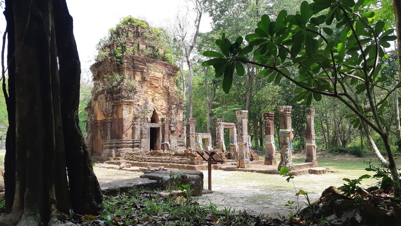
 Click to Access the Navigation Map GPS
 Historical Sites and Monuments(12)
 Landmarks and Memorials(1)
 Art, Craft Centres, Tradition(8)
 Places of Worship
 Temple(13)
 Other Sacred Sites(3)
 Suburban Living
 Village, Community(2)
 Nature and Wildlife
 National Parks and Marine Reserves(2)
 Dam, Reservoir, Lake(7)
 Waterfalls(5)
 River, Canal(5)
 Bays and Beaches(2)
 Entertainment and Agricultural
 Zoos and Aquariums(1)
 Farms, Parks and Ecotourism(3)


