
lovethailand home >Northeastern Travel Attractions >Si Sa Ket Travel Attractions >Khun Han >Bak Dong > Samrong Kiat Waterfall
TL;DR: Samrong Kiat Waterfall is located at Ban Samrong Kiat, Bak Dong Subdistrict, Khun Han District, Si Sa Ket Province, open Daily, hours 08.30 – 16.30.
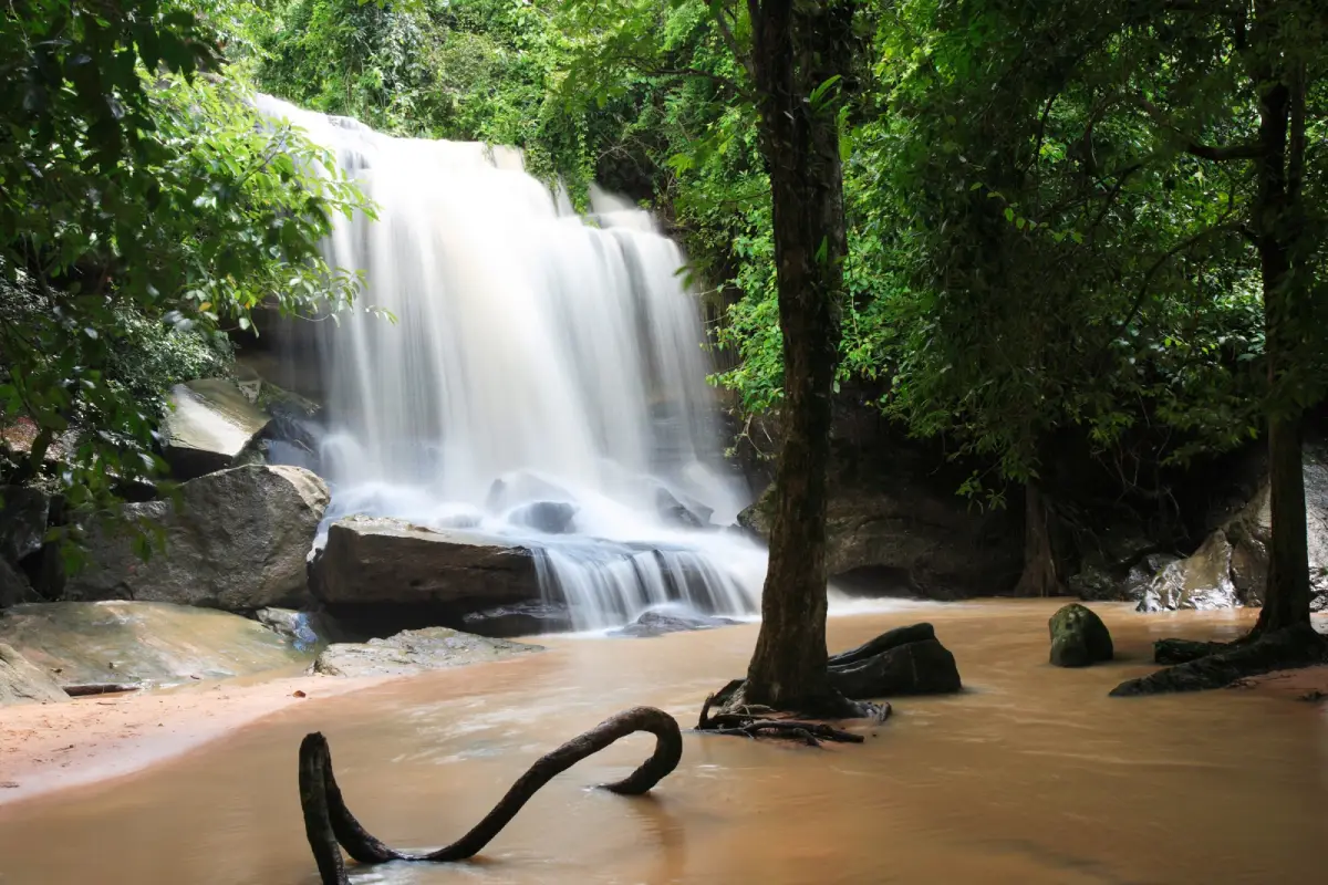
Samrong Kiat Waterfall
Open Days: Daily
Opening Hours: 08.30 – 16.30
Samrong Kiat Waterfall, also known as Devil Waterfall, is one of the best-known natural attractions in Khun Han District, Si Sa Ket Province. Located in the Ban Samrong Kiat area of Bak Dong Subdistrict, within the natural landscape of Phanom Dong Rak Wildlife Sanctuary and Samrong Kiat Waterfall Arboretum, this medium-sized waterfall is fed by streams from Mount Kanthung in the Phanom Dong Rak mountain range. Its main cascade drops from a sandstone cliff about 8 meters high, while the upper section features a stream flowing across a broad rock platform before falling into the lower pool. From September to February, when the water level is at its best, the waterfall becomes especially attractive, with white water spreading over the rock face and green forest surrounding the entire area.
Samrong Kiat Waterfall is not only a scenic waterfall but also a place with local history. Its former name, “Devil Waterfall”, came from the nickname of a paramilitary ranger unit that once used this area as an operational base. Later, when the site was improved and developed as a community-based natural attraction, it was renamed Samrong Kiat Waterfall after the nearby village. Many Thai travelers still recognize both names, so the place is often referred to as Samrong Kiat Waterfall or Devil Waterfall. For foreign visitors, this dual name gives the waterfall an added layer of local identity, connecting natural scenery with borderland history.
The landscape around Samrong Kiat Waterfall reflects the character of southern Si Sa Ket, where the province rises toward the Phanom Dong Rak range near the Thai-Cambodian border. Instead of flat agricultural land, the area features forest, hills, rocky ground, streams, sandstone layers, and natural watercourses shaped by seasonal rainfall. Above the main fall, water flows over a wide rock terrace before dropping from the cliff. This creates several viewing points: the upper rock platform, the flowing stream, the cliff edge, and the lower cascade. The result is a waterfall experience that feels broader and more layered than a single vertical drop.
The waterfall’s water source comes from Mount Kanthung in the Phanom Dong Rak range. Like many waterfalls in northeastern Thailand, its beauty changes with the season. The best period to visit is from around September to February, when rainfall and upstream flow give the waterfall more volume. During this period, the surrounding forest is greener, the air feels fresher, and the stream across the rock platform becomes more photogenic. Travelers who want to see the waterfall in its most attractive condition should plan their visit during the late rainy season or cool season.
The main drop is about 8 meters high. Although it is not a very tall waterfall, the wide rock surface and shaded forest setting give the place strong visual appeal. When water pours over the cliff, it spreads into a white curtain and splashes onto the rocks below, creating a lively but not overwhelming sound. The lower area is used for relaxing, photography, and water recreation. Visitors should choose safe spots for entering the water and avoid fast-flowing water, slippery rocks, and unclear pools, especially during rainy weather or after heavy rain.
Samrong Kiat Waterfall is suitable for families, groups of friends, nature travelers, and visitors looking for a relaxing day outdoors. It is easier to access than many remote forest waterfalls, making it popular among residents of Si Sa Ket and nearby provinces. Travelers can drive close to the waterfall area, then spend time around the stream, rock terrace, and waterfall. During weekends, public holidays, and the hot season, local visitors often come here to rest, play in the water, enjoy simple outdoor meals, and cool down in the shaded forest environment.
The atmosphere around the waterfall is calm and green. Trees provide shade, while the surrounding forest helps preserve moisture and coolness. Sitting near the waterfall gives visitors a sense of rest that is very different from urban sightseeing. The sound of water, insects, birds, and leaves creates a natural rhythm. For photographers, the site offers many useful angles: the cascade from the front, the stream flowing over the upper rock platform, water moving over smaller rocks, and forest scenery around the waterfall. In soft morning or afternoon light, the water and trees appear especially vivid.
Samrong Kiat Waterfall is also a good place to understand the importance of watershed forest. The waterfall exists because the mountain, forest, rock surface, and stream system remain connected. When forest cover is healthy, water can continue to flow through the landscape. When forest is damaged, streams and waterfalls are affected. A visit here is therefore not only about whether the waterfall looks beautiful on a particular day. It is also an opportunity to see how forest conservation supports water, tourism, and local community life.
As a natural attraction, Samrong Kiat Waterfall should be visited responsibly. Travelers should take their trash back out, use resting areas properly, avoid loud noise, and keep fragile items away from the stream. Climbing on wet rocks is dangerous, especially during the rainy season. Water recreation should be limited to safe areas, and visitors should never underestimate the current. Even when the water surface looks calm, the depth and flow can change quickly after rain.
The waterfall is managed within a conservation context. It is associated with Samrong Kiat Waterfall Arboretum and the Phanom Dong Rak Wildlife Sanctuary landscape under natural resource and environmental authorities. This means tourism is connected to forest protection, wildlife habitat, and ecosystem care. Visitors should follow local rules, avoid walking outside designated areas, and use the site in a way that does not disturb the natural setting.
One of the most distinctive aspects of Samrong Kiat Waterfall is the combination of natural beauty and local historical memory. The former name “Devil Waterfall” reflects the area’s past connection with border security and paramilitary operations, while the current name links the place to Ban Samrong Kiat community. Together, these names make the waterfall more meaningful than an ordinary scenic stop. Travelers interested in local identity will find that this destination carries both environmental and historical layers.
For a relaxed visit, travelers should allow at least 1–2 hours at the waterfall. This gives enough time to walk around the safe viewing areas, photograph the rock terrace, listen to the water, and rest in the shaded surroundings. During the high-water season, visitors may want to stay longer because the waterfall is more impressive and photography opportunities are better. Families and groups should try to arrive in the morning or early afternoon to avoid spending time in a forested area close to dusk.
Samrong Kiat Waterfall can be combined with several other attractions in Khun Han District and nearby areas. Wat Pa Maha Chedi Kaew, widely known as the Million Bottle Temple, is one of the most famous cultural sites in Si Sa Ket. Other natural attractions include Huai Wang Yai Waterfall and Phu La Or Waterfall, while Pha Mo I Daeng in Kantharalak District can be included in a longer borderland route. Travelers with one full day can combine waterfall scenery with a temple visit. Those with 2 days can stay overnight in Khun Han or nearby districts and continue toward the Phanom Dong Rak border route and volcanic-soil fruit-growing areas.
During holidays and long weekends, the waterfall becomes especially popular with local visitors. Its accessibility, shade, and water recreation make it a convenient place for a nature break. When the site is busy, responsible behavior becomes more important. Visitors should keep the area clean, avoid leaving food waste and plastic, and respect other travelers using the same natural space.
The rainy season brings the most beautiful water flow, but it also requires the most caution. Rock surfaces can become slippery, water may run stronger, and some areas can change condition quickly. Travelers should check weather conditions before departure, wear suitable footwear, and avoid standing near edges or strong currents. Photography should be done from stable ground, not from dangerous rock surfaces.
The cool season is also a good time to visit. The waterfall usually still has water, the temperature is more comfortable, and the forest remains pleasant for resting. This period is suitable for families, older visitors who can walk comfortably, and travelers who prefer to avoid heavy rain. In the hot season, the water level may be lower, but the area can still serve as a shaded natural retreat.
Travelers who want good photographs should visit in the morning or late afternoon when the light is softer. Harsh midday light can make the water appear too bright, while softer light gives better detail in the forest and rocks. Camera and phone protection is useful because the area can be humid, and spray from the waterfall may reach nearby rocks. A waterproof pouch is helpful, especially in the rainy season.
Preparation should focus on comfort and safety. Good footwear, quick-drying clothes, a towel, drinking water, mosquito repellent, a trash bag, and waterproof storage for valuables are useful items. Visitors who plan to play in the water should bring extra clothes. Soap and shampoo should never be used in the stream because chemicals harm the natural water system.
Samrong Kiat Waterfall helps travelers see another side of Si Sa Ket Province. The province is often known for Khmer ruins, temples, and volcanic-soil fruit orchards, but its southern districts also contain forests, waterfalls, border mountains, and conservation areas. Visiting this waterfall adds a natural dimension to a Si Sa Ket itinerary and helps travelers understand the province beyond its cultural landmarks.
The upper stream is one of the key features to observe. Before the water drops from the cliff, it moves across a broad stone platform. This area shows the journey of the water before it becomes a waterfall. Visitors should view it only from safe points and avoid walking on slippery rock near flowing water. From above, the waterfall feels like a living system rather than a single viewpoint: water, stone, and forest all work together.
The lower viewing area is where most visitors take photos and rest. From this angle, the 8-meter drop, rock formations, and surrounding trees create a balanced natural scene. During periods of strong flow, the waterfall appears fuller and more powerful, making it an especially good place for photography. The sound of water falling onto the rocks adds to the sense of freshness and movement.
For travel planning, Samrong Kiat Waterfall works well as a trip from Si Sa Ket city or Khun Han town. From Si Sa Ket city, the distance is about 81 km, so travelers should allow enough travel time. From Khun Han, the route is shorter and easier to combine with nearby attractions such as Wat Pa Maha Chedi Kaew and local places around Bak Dong Subdistrict. A private car or rental vehicle is the most practical option.
Getting There is most convenient by private car. From Si Sa Ket city, travel toward Khun Han District using Highway 2111. Once in Khun Han District, continue onto Highway 2127, the Khun Han–Samrong Kiat route, for about 20 km. The waterfall is located slightly uphill to the south beyond Ban Samrong Kiat. The total distance from Si Sa Ket city is about 81 km. Travelers using public transport should first reach Khun Han, then arrange local transport or a chartered vehicle to the waterfall area, as regular transport to natural attractions is limited.
Samrong Kiat Waterfall is one of the most rewarding natural stops in Si Sa Ket for travelers who want forest scenery, flowing water, local history, and a less urban travel experience. Its beauty is not limited to the main cascade. It includes the upper rock platform, shaded trees, the sound of water, its former identity as Devil Waterfall, and its role as a community recreation area. When visited with care and respect, the waterfall remains a valuable and memorable destination in southern Si Sa Ket.
| Name | Samrong Kiat Waterfall, also known as Devil Waterfall |
| Location | Ban Samrong Kiat, Bak Dong Subdistrict, Khun Han District, Si Sa Ket Province |
| Address | Samrong Kiat Waterfall Arboretum, Ban Samrong Kiat Tai, Bak Dong Subdistrict, Khun Han District, Si Sa Ket 33150, Thailand |
| Highlights | A medium-sized waterfall in the Phanom Dong Rak forest landscape, dropping from an 8-meter sandstone cliff with an upper stream flowing across a wide rock platform. |
| History | Formerly called Devil Waterfall after the nickname of a paramilitary ranger unit that once used the area as an operational base. In 2006, after the area was improved as a tourist attraction, it was renamed Samrong Kiat Waterfall after the local village. |
| Name Origin | The former name, Devil Waterfall, came from the nickname of the ranger unit. The current name comes from Ban Samrong Kiat, the village in the area. |
| Distinctive Features | Fed by streams from Mount Kanthung in the Phanom Dong Rak range. The waterfall is most beautiful from September to February, when the water flow is stronger and the surrounding forest is green. |
| Travel Information | From Si Sa Ket city, travel to Khun Han District via Highway 2111. In Khun Han, continue onto Highway 2127, the Khun Han–Samrong Kiat route, for about 20 km. The waterfall is slightly uphill to the south beyond Ban Samrong Kiat, about 81 km from Si Sa Ket city. |
| Current Status | Open as a natural tourist attraction in Khun Han District, Si Sa Ket Province. |
| Open Days | Daily |
| Opening Hours | 08.30 – 16.30 |
| Facilities | Resting areas, water recreation areas, natural viewpoints, toilets, and camping area. |
| Main Areas / Zones | Entrance And Parking Area Streamside Resting Area Upper Rock Platform Main 8-Meter Waterfall Cliff Lower Pool And Water Recreation Area Camping Area Forest And Arboretum Zone |
| Caretaker | Samrong Kiat Waterfall Arboretum / Phanom Dong Rak Wildlife Sanctuary, under natural resource and environmental authorities. |
| Main Contact Number | 0-4451-4447 063-565-9399 |
| Official Website / Official Page | Bak Dong Subdistrict Administrative Organization / Si Sa Ket Provincial Office of Natural Resources and Environment / Samrong Kiat Waterfall Arboretum Official Page |
| Nearby Tourist Attractions | 1. Prasat Tamnak Sai, about 5 km 2. Wat Samrong Kiat, about 6 km 3. Wat Pa Maha Chedi Kaew, also known as the Million Bottle Temple, about 22 km 4. Huai Wang Yai Waterfall, about 24 km 5. Phu La Or Waterfall, about 38 km 6. Pha Mo I Daeng, about 65 km |
| Nearby Restaurants | 1. Kan-Aeng Coffee & Tea, about 18 km, Tel. 093-412-3723 2. Indy Coffee Bar & Restaurant, about 21 km, Tel. 099-069-5889 3. Khun Han Breakfast, about 22 km, Tel. 095-605-7004 4. MOMOCHA Taiwan Bubble Tea Khun Han, about 22 km, Tel. 064-959-0476, 062-441-9235 5. Pongsin Resort And Restaurant, about 30 km 6. Krau Peace Pool At Peace Pool Resort, about 23 km, Tel. 087-508-3617 |
| Nearby Accommodations | 1. Peace Pool Resort, about 23 km, Tel. 087-508-3617 2. Kradung Nga Boutique Inn, about 24 km, Tel. 045-962-607 3. Pongsin Resort And Restaurant, about 30 km 4. Rerawadi Hotel And Spa, about 24 km 5. Kradung Nga Boutique Inn, about 24 km, Tel. 081-321-4163 6. Rerawadi Resort, about 24 km |
Frequently Asked Questions (FAQ)
Q: Where is Samrong Kiat Waterfall located?
A: Samrong Kiat Waterfall is located at Ban Samrong Kiat, Bak Dong Subdistrict, Khun Han District, Si Sa Ket Province, within the natural area of Samrong Kiat Waterfall Arboretum and the Phanom Dong Rak Wildlife Sanctuary landscape.
Q: What days and hours is Samrong Kiat Waterfall open?
A: It is open daily from 08.30 to 16.30.
Q: When is the best time to visit Samrong Kiat Waterfall?
A: The best time to visit is from September to February, when the waterfall has more water, the forest is greener, and the stream above the cliff flows beautifully across the rock platform.
Q: Why is Samrong Kiat Waterfall also called Devil Waterfall?
A: The former name, Devil Waterfall, came from the nickname of a paramilitary ranger unit that once used this area as an operational base. The waterfall was later renamed Samrong Kiat Waterfall after the local village.
Q: What are the main highlights of Samrong Kiat Waterfall?
A: The main highlights are the 8-meter waterfall cliff, the stream flowing across the upper rock platform, shaded forest, natural water recreation areas, photography spots, and the peaceful atmosphere of the Phanom Dong Rak forest landscape.
Q: How do travelers get to Samrong Kiat Waterfall?
A: From Si Sa Ket city, travel to Khun Han District via Highway 2111, then continue along Highway 2127 on the Khun Han–Samrong Kiat route for about 20 km. The waterfall is slightly uphill to the south beyond Ban Samrong Kiat.
Q: Is Samrong Kiat Waterfall suitable for families?
A: Yes. It is suitable for families who want to relax, play in the water, and enjoy nature. Children should be supervised at all times, especially around slippery rocks, rock platforms, and strong-flowing water.
Q: What nearby attractions can be visited with Samrong Kiat Waterfall?
A: Nearby attractions include Prasat Tamnak Sai, Wat Samrong Kiat, Wat Pa Maha Chedi Kaew or the Million Bottle Temple, Huai Wang Yai Waterfall, Phu La Or Waterfall, and Pha Mo I Daeng.
 Category: ●Nature and Wildlife
 Group: ●Waterfalls
Last Update : 2 MonthAgo
 Last Update : 2 MonthAgo
 Click to Access the Navigation Map GPS
Samrong Kiat Waterfall Map

 Art, Culture and Heritage
 Historical Sites and Monuments(12)
 Landmarks and Memorials(1)
 Art, Craft Centres, Tradition(8)
 Places of Worship
 Temple(13)
 Other Sacred Sites(3)
 Suburban Living
 Village, Community(2)
 National Parks and Marine Reserves(2)
 Dam, Reservoir, Lake(7)
Waterfalls(5)
Dam, Reservoir, Lake(7)
Waterfalls(5)
 River, Canal(5)
 Bays and Beaches(2)
 Entertainment and Agricultural
 Zoos and Aquariums(1)
 Farms, Parks and Ecotourism(3)


