
lovethailand home >Northeastern Travel Attractions >Nakhon Ratchasima Travel Attractions >Pak Thong Chai >Sakae Rat > Prasat Bueng Kham (Ku Kasem)
TL;DR: Prasat Bueng Kham (Ku Kasem), Nakhon Ratchasima attractions : Art, Culture and Heritage, Historical Sites and Monuments.
Prasat Bueng Kham (Ku Kasem)
Open Days: Daily, as this is an open-air archaeological site
Opening Hours: 08:00 – 17:00 is the recommended visiting period. Travelers should confirm local access conditions with the Sakae Rat Subdistrict Administrative Organization before departure.
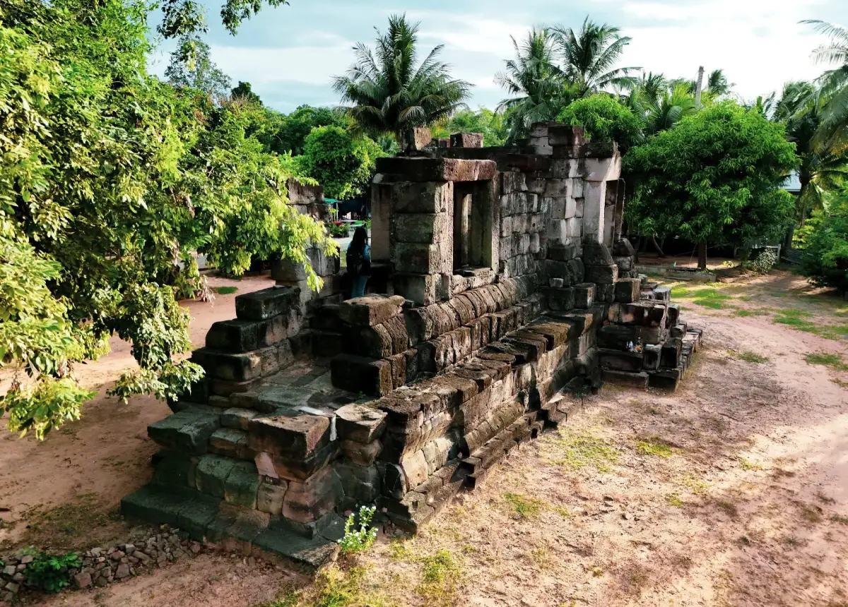
Prasat Bueng Kham, also known as Ku Kasem or Prang Ku Kasem, is an ancient Khmer sanctuary in Ban Khlong Toei, Moo 5, Sakae Rat Subdistrict, Pak Thong Chai District, Nakhon Ratchasima Province. The monument consists of a single sanctuary tower constructed almost entirely from sandstone. It has a square plan with multiple recessed corners, an elongated eastern porch, one functional doorway, 3 false doors, and stone-baluster window openings along the side walls of the porch. The upper roof and tower have largely collapsed, and very little carved decoration survives. Archaeological evidence, particularly a pedestal designed to support a Shiva linga, identifies the monument as a Shaivite Hindu sanctuary. It was probably built around the middle of the 16th Buddhist century, corresponding approximately to the early 11th century CE, and is therefore close to 1,000 years old. The archaeological area has no formal ticket office and no published admission charge. It is suitable for travelers interested in Khmer architecture, archaeology, religious history, and quiet cultural destinations away from major tourist routes.
The same monument appears in local records under several names, including Prasat Bueng Kham, Ku Kasem, and Prang Ku Kasem. The word ku is commonly used in northeastern Thailand for an ancient sanctuary, small religious tower, funerary structure, or sacred ruin. In the context of ancient Khmer culture, prasat does not mean a residential castle in the European sense. It describes a sacred tower representing the dwelling place of a deity. The central building was consequently designed for worship and ritual rather than human residence.
Ku Kasem stands within the rural landscape of Ban Khlong Toei, surrounded by agricultural land and a living local community. Its quiet setting allows visitors to examine the surviving sandstone construction without the congestion often found at major historical parks. Although the tower is relatively small and incomplete, it confirms that the Sakae Rat and Pak Thong Chai area was connected to wider networks of Khmer religion, political influence, craftsmanship, and regional travel across the Khorat Plateau approximately 1,000 years ago.
The establishment of a Hindu sanctuary in this location demonstrates that ancient settlements were not confined to major urban centers such as Phimai. Smaller communities were distributed near water sources, productive agricultural land, natural corridors, and routes linking the Khorat Plateau with areas farther south and east. Ku Kasem probably served as a religious center for a local settlement or an elite group with access to labor and stone-building technology. A Shiva linga enshrined inside the tower would have been the focus of offerings and rituals performed by the surrounding community.
The monument is generally dated to around the middle of the 16th Buddhist century and is associated with the early period of King Suryavarman I, approximately the early 11th century CE. Some references provide a broader date spanning the 16th to 17th Buddhist centuries because most carved architectural elements have disappeared and no dated inscription has been discovered at the site. Nevertheless, its overall design indicates that the sanctuary is around 900–1,000 years old. It predates the numerous Jayavarman VII-period hospital chapels constructed in the 18th Buddhist century.
This period witnessed the continued expansion of Khmer cultural and political influence across the Khorat Plateau. Settlements and sanctuaries were linked through movement, exchange, religious institutions, and access to natural resources. Architectural ideas developed in major centers were adapted to local materials, craftsmen, available labor, and the requirements of individual communities. The region therefore contains both large multi-building temple complexes and compact single-tower sanctuaries. Ku Kasem belongs to the latter category: a small but formally planned sacred building with a clearly defined ritual axis.
The tower was constructed almost entirely from sandstone. This distinguishes it from many monuments in Nakhon Ratchasima that used brick or laterite for major structural masses and reserved sandstone for doorframes, lintels, columns, and sculpture. Building an entire tower from sandstone required access to a suitable quarry, trained stoneworkers, transportation, and a coordinated labor force. Each block had to be extracted, shaped, transported to Ban Khlong Toei, and placed in a carefully controlled arrangement capable of supporting the immense weight of the upper structure.
The main plan is square and measures approximately 12 by 12 m, including the principal structural area. Its exterior incorporates repeated recessed offsets, a form described in Thai architectural terminology as yo mum mai yi sip, or a plan with 20 recessed corners. These offsets create alternating projections and shadows instead of a single flat wall. They also make the tower appear more vertical and visually complex. Although the roof has collapsed, the remaining wall alignments allow visitors to recognize the rhythm of the original design.
The sanctuary faces east, an orientation frequently used in ancient Khmer religious architecture. The east was associated with sunrise, illumination, renewal, and the ceremonial approach to the sacred interior. Only the eastern doorway was functional. The northern, southern, and western sides were formed as false doors that resembled entrances but did not open into the chamber. False doors maintained the architectural balance of the tower and symbolically extended the divine presence toward all directions while controlling physical access through a single ceremonial entrance.
A long projecting porch or antechamber extends approximately 5.80 m from the eastern doorway. This space created a transition between the external world and the inner sanctuary. Worshippers may have paused there to prepare offerings, light lamps, or arrange themselves before approaching the linga. The porch also established a strong visual and processional axis. Visitors were directed through the eastern opening toward the most sacred point at the center of the tower.
The side walls of the porch contain window openings fitted with stone balusters. Older tourism descriptions sometimes summarize the design as 2 principal window openings on each side, while detailed architectural inventories record a longer sequence of baluster openings and additional openings beside the eastern entrance. The difference reflects the way individual wall sections were recorded and the changing condition of the ruin. All descriptions agree that stone-baluster windows were a prominent feature of the entrance porch.
The balusters were turned stone elements arranged vertically within the window frames. They admitted limited light and ventilation while maintaining a clear boundary around the sacred interior. Sunlight passing between the balusters would have created changing patterns of light and shadow within the porch. Many balusters are now missing or displaced, but the surviving openings remain essential evidence for reconstructing the original architectural appearance.
The inner chamber, or garbhagriha, was the most sacred area of the sanctuary. A Shiva linga once stood upon a specially formed pedestal inside or immediately associated with this chamber. The discovery of the pedestal is the clearest evidence that Ku Kasem functioned as a Shaivite temple. During worship, water, milk, or other ritual liquids could be poured over the linga. The liquid flowed through the pedestal’s drainage channel and emerged as a consecrated substance that devotees could receive or use for blessing.
Shiva is one of the principal deities of Hindu tradition and is associated with creation, transformation, destruction, ascetic power, and the renewal of cosmic order. Worship through the linga was widespread throughout the ancient Khmer world and could also express political authority, fertility, territorial protection, and the sacred legitimacy of local rulers. The presence of a Shaivite sanctuary at Ban Khlong Toei shows that the community participated in religious traditions linked to the broader Khmer cultural sphere.
No clearly preserved decorative carving can now be identified on the lintels, pediments, wall surfaces, or other architectural components. This plain appearance has generated 2 interpretations. Some earlier local accounts proposed that carving was never completed before construction ceased. Other conservation records suggest that the essential architecture was completed for its intended use and that limited decoration may have been deliberate, unfinished only in part, or subsequently lost.
The absence of carving alone does not prove that the temple was abandoned before completion. The monument contained all major elements required for ritual use: an inner chamber, a functional eastern doorway, false doors, an entrance porch, baluster windows, and a linga pedestal. These features indicate that religious ceremonies could take place within the building. Its decorative program may simply have been less elaborate than that of a major royal temple, or carved components may have been removed, broken, or weathered beyond recognition.
The roof and upper tower have collapsed almost completely. The original superstructure probably rose in diminishing tiers above the main chamber and ended in a crowning element typical of Khmer sanctuary towers. Collapse may have resulted from the immense weight of the sandstone, differential foundation movement, rainwater penetration, thermal expansion, vegetation, and centuries of human disturbance. Once part of the structural system shifted, stones in the upper courses gradually lost support and fell.
Archaeological research into the foundations of Ku Kasem has increased the importance of the site beyond its visible walls. Foundation studies reveal how ancient builders prepared the ground, selected materials, distributed structural loads, and attempted to control settlement. Evidence indicates that materials with suitable physical properties were deliberately incorporated into the foundation rather than using random soil and rubble. Such preparation reflects engineering knowledge acquired through experience and transmitted between groups of builders.
Constructing a sandstone sanctuary began with orientation, surveying, and careful leveling. The eastern doorway had to align precisely with the center of the inner chamber. The foundation then had to carry the weight of thousands of stone blocks without uneven settlement. Each course of masonry required control of wall lines, corners, and vertical alignment. A small error at the lowest level would have become increasingly serious as construction rose. The monument therefore represents not only religious belief but also organized technical knowledge and project management.
The sandstone had to be obtained from a source with suitable grain, strength, and workable bedding. Quarry workers separated blocks from the natural rock, while masons shaped them according to their intended positions in the wall, doorway, baluster windows, or upper structure. Moving the blocks to Ban Khlong Toei required human labor, draft animals, prepared ground routes, or seasonal waterways. The process indicates a considerable ability to mobilize labor and resources.
No surviving inscription identifies the original name of the sanctuary, its founder, or the exact year of construction. Nevertheless, the scale of the project indicates support from an individual or group with sufficient authority to obtain stone, craftsmen, transport, and labor. The patron may have been a local elite, an official connected to a larger political center, or a community seeking to establish a permanent place of worship. Installing a Shiva linga also linked religious practice with authority and social legitimacy.
When Ku Kasem is considered alongside Phimai, Phanom Wan, Prasat Mueang Khaek, Prasat Non Ku, and other monuments in Nakhon Ratchasima, the Khorat Plateau appears as a landscape containing a dense hierarchy of religious sites. Major complexes served cities and regional centers, while small single-tower sanctuaries supported more localized communities. Studying both levels is essential for understanding the organization of settlement and society. Ku Kasem provides information that cannot be obtained from monumental royal temples alone.
The location near the modern Highway 304 corridor also emphasizes the long-term importance of regional geography. Ancient routes did not follow every section of the present highway, but communities repeatedly developed in areas with access to water, farmland, passes, and practical connections between the plateau and regions farther south. The presence of a sanctuary at Ban Khlong Toei suggests that the locality supported a permanent community or a significant stopping point within an older network of movement.
Ku Kasem has been registered as a national ancient monument, and a protected archaeological boundary covers approximately 1 rai, 2 ngan, and 60 square wah. Legal protection applies not only to the standing walls but also to underground deposits, displaced stone blocks, artifacts, and surrounding archaeological evidence. Visitors must not move stones, collect pottery fragments, dig, carve names into surfaces, light fires beside the structure, or remove any material from the site. Even a very small object may provide information about chronology and past activity.
The monument is currently in a partially collapsed condition, particularly at the roof and upper wall levels. Conservation authorities have installed structural bracing along the southern side to control movement and reduce the risk of further collapse. The bracing is not part of the ancient architecture. It is an engineering measure supporting the unstable structure while its condition is monitored and conservation options are assessed. Visitors must not touch, climb, or enter any area associated with the supports.
Conservation does not mean rebuilding every missing part to create a new-looking temple. Professional work begins with recording stone positions, measuring wall movement, documenting cracks, studying foundations, and identifying the original relationship between components. Stones can be returned to their former position only when evidence is sufficient. Where the original arrangement cannot be demonstrated, stabilization and documentation are more appropriate than reconstruction based on imagination.
The Fine Arts Department, through the 10th Regional Office of Fine Arts in Nakhon Ratchasima, is responsible for archaeological and structural conservation. The Sakae Rat Subdistrict Administrative Organization supports environmental maintenance, community education, local access, and tourism development. Effective management therefore depends on cooperation among professional conservators, local government, village leaders, and the residents of Ban Khlong Toei.
Community learning activities held at Prang Ku Kasem allow children and young residents to understand the heritage of their own area. Studying the real monument makes subjects such as Hindu religion, stone construction, orientation, structural deterioration, and conservation easier to understand than textbook descriptions alone. When the community recognizes the value of the sanctuary, residents are better prepared to prevent encroachment, report damage, and pass local knowledge to future generations.
A visit should begin on the eastern side, the original front of the temple. From a moderate distance, travelers can see the entrance porch, the real doorway, and the inner chamber aligned along the same axis. Observing the entire form before approaching individual stones makes the structure easier to understand. Visitors can then move closer to examine the doorway frames, window openings, masonry joints, and recessed wall plan.
The first major area is the projecting porch with its stone-baluster window openings. Beyond it stands the eastern doorway leading toward the former position of the Shiva linga. Visitors can then walk around the northern, western, and southern sides to compare the false doors and the repeated wall offsets. A safe distance must be maintained from the conservation bracing on the southern side and from any barrier installed by the authorities.
For interpretation, the archaeological area can be divided into the eastern approach and porch, the inner sanctuary, the 3 false doors, the recessed wall and foundation zones, the area associated with the linga pedestal, the southern conservation-bracing zone, and the landscaped learning area surrounding the tower. These are not necessarily separated by modern gates, but the sequence helps visitors examine the monument systematically.
The joints between sandstone blocks deserve close attention. The stones were cut to meet without modern brick mortar, relying on weight, close fitting, and carefully planned courses. Some blocks retain shoulders, grooves, or finished surfaces designed to receive adjoining elements. Moving a single stone can therefore affect the stability of several surrounding blocks. This interdependence explains why visitors must not rearrange fallen pieces even when they appear loose or unimportant.
The eastern doorway provides a view toward the sacred chamber, but travelers should not cross a barrier or enter an unstable section. Stones above doorframes are particularly sensitive because the structural load has shifted after the loss of the upper tower. The false doors are safer points from which to study symmetry and design. Comparing them with the eastern doorway reveals how the builders created a balanced exterior while reserving physical access for only one direction.
Morning is the best period for viewing the eastern façade because sunlight brings out the texture of the sandstone and illuminates the entrance axis. Late afternoon is more suitable for examining the western side and avoiding the strongest heat. The site is open and offers limited shade, so visitors should carry drinking water, a hat or umbrella, and footwear appropriate for uneven ground.
November to February generally provides the most comfortable conditions for outdoor exploration. March to May can be extremely hot, making visits before 10:00 or after 15:00 preferable. The rainy season creates greener surroundings, but grass and soil may become slippery. Travelers should check weather conditions and avoid standing close to unstable masonry during heavy rain or strong wind.
The eastern angle is the most useful position for photographing the porch, doorway, and main tower together. Oblique views reveal the recessed corners and depth of the entrance structure, while side views show the baluster openings and false doors. A longer lens or a change of position should be used instead of climbing the foundation. Including farmland, trees, or the village landscape in photographs helps communicate that the temple remains part of a living cultural environment.
Visitors should not lean against walls, place belongings on stones, or enter the braced section. Sandstone appears solid but its surface can gradually flake through weathering, repeated contact, and moisture. Climbing also introduces vibration and localized pressure into an already unstable structure. Maintaining a respectful distance is one of the most direct ways travelers can contribute to conservation.
Incense, candles, oil, and food offerings should not be placed against the ancient walls. Heat, smoke, wax, and oil produce stains and accelerate surface deterioration. When the community has provided a designated worship point, visitors should use that area. Respect for local belief can be combined with responsible conservation without touching or modifying original architectural components.
Adults visiting with children should explain that an archaeological monument is not a climbing area. Stone blocks lying on the ground may be essential architectural evidence and must not be moved. Children can instead be encouraged to identify the real doorway, locate the 3 false doors, observe the baluster shapes, and compare the changing shadows on the recessed walls.
Approximately 45–90 minutes is sufficient for a meaningful visit. A traveler stopping only for photographs may spend around 30 minutes, but those interested in architecture should walk around the tower, read available information, and study the foundation, materials, and layout. Because the archaeological area is compact, it can easily be combined with other attractions in a half-day or full-day itinerary.
Facilities are basic. Parking is available close to the area, and the monument stands within an open outdoor space, but there is no large visitor center, internal transport service, or extensive group of shops. Travelers should obtain water and use restrooms at service stations, shops, or community facilities before arriving. Older visitors can view the monument from the surrounding ground, although some surfaces are uneven. Wheelchair users should travel with assistance and assess access conditions before approaching the tower.
Getting There from Nakhon Ratchasima city requires following Highway 304 toward Pak Thong Chai. Continue through Pak Thong Chai District for approximately 11 km until reaching the area around kilometer marker 92. Turn left onto a local road and travel approximately 2 km to Ban Khlong Toei. Turn left again and continue for another 1 km to Prasat Bueng Kham. The final approach passes through rural roads and the village. Navigation can be set to approximately 14.598003, 102.016878.
A private car or rental vehicle is the most convenient option because no scheduled public transport travels directly to the monument. Travelers using public transport can reach Pak Thong Chai and arrange a local hired vehicle to Ban Khlong Toei. The fare, return time, and meeting point should be agreed upon in advance because no regular taxi service waits at the archaeological site.
Road conditions should be confirmed with the Sakae Rat Subdistrict Administrative Organization, particularly during the rainy season or periods of local road maintenance. The turning point into Ban Khlong Toei can be easy to miss, so offline navigation and careful attention to local signs are useful. Fuel should be purchased along Highway 304 or in Pak Thong Chai before entering the smaller community roads.
Nearby places that can be combined with Ku Kasem include Sakaerat Environmental Research Station, an important center for dry-evergreen forest research and biosphere conservation; Wat Na Phra That or Wat Takhu, known for its old ordination hall and traditional water library; the Pak Thong Chai silk community; Jim Thompson Farm when public activities are officially scheduled; and Lam Phra Phloeng Dam, a reservoir landscape suitable for sightseeing and relaxation.
Travelers interested in both archaeology and nature can visit Ku Kasem early in the morning and continue to Sakaerat Environmental Research Station. Forest activities and accommodation at the station should be reserved in advance because some programs require staff supervision. Another option is to continue toward central Pak Thong Chai for lunch, visit the silk community, and explore Wat Na Phra That within the same day.
Jim Thompson Farm is a famous nearby attraction, but it does not operate as an everyday year-round tourist site. Public programs and opening periods depend on official announcements. Travelers must check the farm’s current website or social-media channels before including it in an itinerary and should not rely on schedules published for previous years.
Lam Phra Phloeng Dam is suitable as a late-afternoon destination. Its mountain and reservoir scenery provides a clear contrast with the archaeological landscape of Ku Kasem. A route combining the ancient sanctuary, Pak Thong Chai community culture, and the reservoir allows visitors to experience history, local craftsmanship, and the natural environment within a single district.
Most nearby food options are small local restaurants and cafés around Ban Khlong Toei, Sakae Rat, and Highway 304. Convenient choices include Je Wai Boat Noodles Khlong Toei, Ung Ing Crepe, Pang Cheese Sakae Rat, Roseyacaffe, and Sigma Cup @NaStay. Groups should call before arrival to confirm opening hours, available seating, and meal service because small local businesses may change their schedules according to staffing and ingredient availability.
Accommodation ranges from nature-study lodging and wellness retreats to small hotels and golf resorts. Sakaerat Environmental Research Station accepts advance accommodation bookings for approved programs and visitors. iRETREAT Pak Thong Chai provides a quiet retreat environment, while Mulberry House Korat and Bosswin Home Resort are closer to the main services of Pak Thong Chai. Korat Country Club Golf & Resort is a more distant option for travelers seeking broader resort facilities.
Distances in the summary table are approximate driving distances from Ku Kasem and may vary with the selected route, starting point, or road conditions. Telephone numbers are included only where publicly listed. Travelers should call to confirm opening status, restaurant hours, room availability, activity schedules, and reservation requirements, especially for small businesses and accommodation operating by advance booking.
Ku Kasem is particularly rewarding for travelers seeking history beyond Thailand’s most famous archaeological parks. Visitors will not find a fully reconstructed tower or a large tourist complex. Instead, they encounter the authentic remains of a 1,000-year-old sandstone sanctuary within its local community setting. The damaged condition of the structure also provides a direct lesson in weathering, foundation movement, structural conservation, and the limits of archaeological reconstruction.
The uncarved surfaces are themselves an important feature. They contrast with the common image of Khmer temples covered in elaborate reliefs and encourage attention to proportion, wall offsets, light, openings, and construction technique. Architecture derives meaning not only from decoration but also from the organization of space, control of movement, orientation, and the gradual transition from the external landscape to the sacred chamber.
The linga pedestal restores a human and ritual dimension to the ruined building. Approximately 1,000 years ago, worshippers approached through the eastern porch carrying offerings and entered a chamber illuminated only by limited natural light. Ritual liquid was poured over the Shiva linga and flowed through the pedestal. Imagining the sound of prayer, the glow of lamps, the scent of offerings, and the movement of the community transforms the ruin into a place that once played an active role in everyday religious life.
Responsible travel includes avoiding damage, removing all rubbish, respecting nearby residents, and supporting local services. Purchasing food, booking accommodation, or hiring transport within the area helps distribute tourism income to the community. Visitors can also assist conservation by respecting barriers and reporting vandalism, encroachment, or unusual movement of stones to the local authority or Fine Arts Department.
Prasat Bueng Kham or Ku Kasem is therefore far more than a small ruin beside a village. It preserves evidence of Shaivite belief, sandstone engineering, regional settlement, and ancient Khmer cultural connections during the early 11th century CE. Its recessed square plan, eastern entrance, 3 false doors, projecting porch, baluster windows, linga pedestal, and carefully prepared foundations express the knowledge and religious priorities of its builders. Although the roof and decorative program have largely disappeared, the monument retains substantial historical value and deserves careful protection for future generations.
| Name | Prasat Bueng Kham, Ku Kasem, or Prang Ku Kasem |
| Location | Ban Khlong Toei, Moo 5, Sakae Rat Subdistrict, Pak Thong Chai District, Nakhon Ratchasima Province |
| Address | Moo 5, Ban Khlong Toei, Sakae Rat Subdistrict, Pak Thong Chai District, Nakhon Ratchasima 30150, Thailand |
| Coordinates | 14.598003, 102.016878 |
| Site Type | Ancient Khmer Shaivite Hindu sanctuary and protected archaeological monument |
| Period And Age | Approximately the middle of the 16th Buddhist century or early 11th century CE, around 900–1,000 years old |
| Highlights | A single sandstone tower with a recessed square plan, eastern porch, one real entrance, 3 false doors, and stone-baluster window openings |
| Approximate Dimensions | The principal plan measures approximately 12 by 12 m, with the eastern porch extending approximately 5.80 m |
| Important Evidence | A Shiva-linga pedestal confirming Shaivite use, together with the foundation, sandstone doorframes, false doors, and baluster-window remains |
| Decoration | No prominent carving survives on the lintels, pediments, or walls; most upper and decorative components have been lost |
| National Protection | Registered as a national ancient monument with a protected archaeological area of approximately 1 rai, 2 ngan, and 60 square wah |
| Main Areas And Zones | 1. Eastern approach and projecting porch 2. Stone-baluster window openings 3. Inner sanctuary and former linga location 4. Northern, southern, and western false doors 5. Recessed walls and foundation zone 6. Southern structural-bracing conservation zone 7. Landscaped learning area surrounding the monument |
| Current Status | Open to visitors; the tower is partially collapsed and has structural bracing on the southern side. Visitors must respect all barriers. |
| Open Days | Daily, as this is an open-air archaeological site |
| Opening Hours | 08:00 – 17:00 is the recommended visiting period; confirm local access conditions before travel |
| Admission Fee | Free admission; there is no ticket office |
| Recommended Visit Duration | Approximately 45–90 minutes |
| Facilities | Nearby parking and an open outdoor viewing area; no large visitor center. Carry water, sun protection, and suitable footwear. |
| Caretaker | Fine Arts Department through the 10th Regional Office of Fine Arts, Nakhon Ratchasima, in cooperation with the Sakae Rat Subdistrict Administrative Organization and Ban Khlong Toei community |
| Main Contact Numbers | Sakae Rat Subdistrict Administrative Organization: +66 44 442 490 10th Regional Office of Fine Arts, Nakhon Ratchasima: +66 44 471 518 |
| Travel Information | From Nakhon Ratchasima, follow Highway 304 through Pak Thong Chai, continue approximately 11 km to kilometer marker 92, turn left for 2 km to Ban Khlong Toei, then turn left and continue another 1 km |
| Nearby Tourist Attractions | 1. Sakaerat Environmental Research Station, approximately 12 km, Tel. +66 98 219 5570, +66 61 102 1707 2. Pak Thong Chai Silk Community And Town Area, approximately 18 km 3. Wat Na Phra That, also known as Wat Takhu, approximately 19 km 4. Jim Thompson Farm, approximately 20 km, Tel. +66 81 928 5442; public access depends on the official annual program 5. Lam Phra Phloeng Dam, approximately 24 km, Tel. +66 44 373 184 |
| Nearby Restaurants | 1. Je Wai Boat Noodles Khlong Toei, approximately 2 km, Tel. +66 93 560 3794, +66 97 831 5580 2. Ung Ing Crepe, approximately 3 km, Tel. +66 93 719 4605 3. Pang Cheese Sakae Rat, approximately 4 km, Tel. +66 98 208 5543 4. Roseyacaffe, approximately 7 km, Tel. +66 93 130 1437 5. Sigma Cup @NaStay, approximately 8 km, Tel. +66 91 455 4649, +66 63 209 8189 |
| Nearby Accommodations | 1. iRETREAT Pak Thong Chai, approximately 10 km, Tel. +66 89 899 5347 2. Sakaerat Environmental Research Station Accommodation, approximately 12 km, Tel. +66 98 219 5570, +66 61 102 1707; advance booking required 3. Mulberry House Korat, approximately 18 km, Tel. +66 81 890 2494, +66 87 958 4689 4. Bosswin Home Resort, approximately 22 km, Tel. +66 44 441 348, +66 81 923 9884 5. Korat Country Club Golf & Resort, approximately 30 km, Tel. +66 44 300 890 |
Frequently Asked Questions (FAQ)
Q: Where is Prasat Bueng Kham or Ku Kasem located?
A: It is located in Ban Khlong Toei, Moo 5, Sakae Rat Subdistrict, Pak Thong Chai District, Nakhon Ratchasima Province, at approximately 14.598003, 102.016878.
Q: When was Ku Kasem built and how old is it?
A: It was probably constructed around the middle of the 16th Buddhist century or early 11th century CE and is approximately 900–1,000 years old.
Q: Which religion was practiced at Ku Kasem?
A: Ku Kasem was a Shaivite Hindu sanctuary. The most important evidence is a pedestal made to support a Shiva linga.
Q: What are the opening hours of Prasat Bueng Kham?
A: The open-air archaeological area can be visited daily. The recommended visiting period is 08:00–17:00, and travelers should confirm current access conditions with the local administrative organization.
Q: Is there an admission fee for Ku Kasem?
A: Admission is free, and there is no ticket office. Visitors should keep the area clean and follow all conservation barriers.
Q: What are the main architectural features of Ku Kasem?
A: It is a single sandstone tower with a recessed square plan, an eastern entrance, 3 false doors, a projecting porch, and stone-baluster window openings.
Q: Can visitors enter or climb the ancient structure?
A: Visitors must not enter restricted or braced areas and must never climb the walls, foundation, or displaced stones because the monument is partially collapsed.
Q: Which attractions can be combined with Ku Kasem in a 1-day trip?
A: Suitable options include Sakaerat Environmental Research Station, the Pak Thong Chai silk community, Wat Na Phra That, Jim Thompson Farm when officially open, and Lam Phra Phloeng Dam.
 Category: ●Art, Culture and Heritage
 Group: ●Historical Sites and Monuments
Last Update : 3 MonthAgo
 Last Update : 3 MonthAgo
 Click to Access the Navigation Map GPS
Prasat Bueng Kham (Ku Kasem) Map
Recommend
 Historical Sites and Monuments(20)
 Landmarks and Memorials(5)
 Art, Craft Centres, Tradition(7)
 Museums(6)
 Art Gallery(1)
 Educational Places
 Educational Gardens, Farm(4)
 Places of Worship
 Temple(29)
 Mosque(1)
 Other Sacred Sites(6)
 Research and Development
 Royal Project(3)
 Suburban Living
 Village, Community(6)
 Local Market(4)
 Floating Market(1)
 Nature and Wildlife
 National Parks and Marine Reserves(3)
 Mountain (Doi)(5)
 Dam, Reservoir, Lake(8)
 Waterfalls(9)
 Hot Springs(1)
 Caves(2)
 Flower Field(1)
 River, Canal(8)
 Bays and Beaches(2)
 Other natural attractions(3)
 Entertainment and Agricultural
 Zoos and Aquariums(1)
 Animal camps and shows(1)
 Farms, Parks and Ecotourism(21)
 Waterpark(2)
 Outdoor and Adventure Activities(6)
 Shopping
 Shopping and Night Market(2)
 Travel Articles, Recipes
 Travel Review, Food Review(6)


