
lovethailand home >Northeastern Travel Attractions >Nakhon Ratchasima Travel Attractions >Muang Nakhon Ratchasima >Ban Pho > Prasat Phanom Wan
TL;DR: Prasat Phanom Wan is located at Ban Makha, Ban Pho Subdistrict, Mueang Nakhon Ratchasima District, Nakhon Ratchasima Province, open Daily, hours 07:30–17:30.
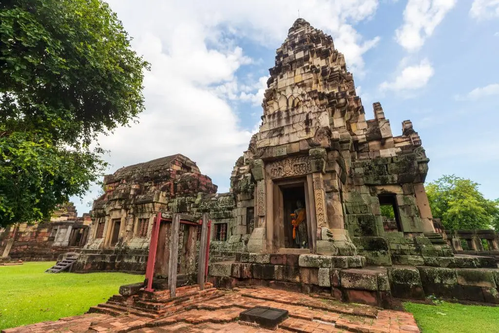
Prasat Phanom Wan
Open Days: Daily
Opening Hours: 07:30–17:30
Prasat Phanom Wan is an ancient Khmer cultural sanctuary at Ban Makha, Ban Pho Subdistrict, Mueang Nakhon Ratchasima District, approximately 15 km from central Nakhon Ratchasima. The archaeological complex developed through several periods. Brick sanctuaries were established around the 15th Buddhist century, major sandstone buildings were constructed during the 16th–17th Buddhist centuries, and the site continued to be modified and used during the 18th–19th Buddhist centuries. Inscriptions identify the sanctuary as “Devasrama,” indicating its original role as a Hindu religious institution before it was adapted for Buddhist worship. Important structures include a cruciform central sanctuary, a mandapa, a connecting passage, a surrounding gallery, four gopuras, Prang Noi, Noen Oraphim, moats, and ancient building foundations. The monument is open daily from 07:30 to 17:30. Admission is 10 baht for Thai citizens and 80 baht for foreign visitors. It is managed by the 10th Regional Office of Fine Arts, Nakhon Ratchasima.
Prasat Phanom Wan is one of the most significant archaeological monuments in Nakhon Ratchasima Province for understanding the relationship between communities on the Khorat Plateau and ancient Khmer culture. Although it is less widely known than Phimai or Phanom Rung, the site is exceptionally valuable for the study of religion, architecture, construction technology, settlement history, and cultural continuity. The complex was not created in a single building campaign. It was built, altered, restored, reused, and reinterpreted over several centuries, leaving visible layers of history throughout the monument.
The sanctuary stands at Ban Makha in Ban Pho Subdistrict, Mueang Nakhon Ratchasima District. It lies within a rural community a relatively short distance from the provincial capital. From central Nakhon Ratchasima, travelers follow Highway 2, or Mittraphap Road, north toward Khon Kaen for approximately 15 km before turning onto a local road leading toward Wat Nong Chok and Ban Makha. The final approach is approximately 5–8 km, depending on the selected junction. Navigation applications may use either “Prasat Phanom Wan” or “Phanom Wan Ancient Monument.” Adding Ban Makha and Ban Pho to the destination helps prevent confusion with similarly named places.
The landscape surrounding the monument differs from that of an archaeological site in a dense urban district or major tourism complex. Prasat Phanom Wan is surrounded by village communities, agricultural land, temples, and local roads. Its atmosphere is generally calm, allowing visitors to observe the gray sandstone, red sandstone, brick, and laterite used in different buildings. Open lawns around the ruins provide clear views of the central tower, galleries, gateways, and outer archaeological features without heavy visual obstruction from modern construction.
The importance of the location began before the Khmer sanctuary was established. Archaeological investigations have uncovered evidence of activity dating to the prehistoric Iron Age, including settlement and burial remains. These discoveries demonstrate that the area formed part of an inhabited landscape before monumental religious architecture appeared. The decision to construct a sanctuary at an already significant location may have been connected to water resources, travel routes, community memory, or an inherited sacred character. Prasat Phanom Wan must therefore be understood as a layered archaeological landscape rather than a single isolated building.
The earliest Khmer cultural religious phase dates to approximately the 15th Buddhist century. Brick buildings were constructed across the area later enclosed by the surrounding gallery. Archaeologists have identified several brick foundations and architectural fragments that belong to this early period. The original group may have differed considerably from the sandstone monument visible today, but it confirms that the location had already become an important ritual center before the major rebuilding campaign.
During the 16th to early 17th Buddhist centuries, the sanctuary underwent a major transformation. The central tower and associated structures were constructed in sandstone over earlier buildings. This phase displays advanced knowledge of stone cutting, doorway construction, foundation planning, and Khmer architectural design. Several areas appear to have remained unfinished. Some stone blocks were never fully polished, while decorative surfaces were prepared but not completely carved. These unfinished details provide unusual evidence of the sequence through which ancient builders shaped, placed, finished, and decorated architectural stone.
Earlier tourism descriptions sometimes date the sandstone rebuilding to the 18th–19th Buddhist centuries, while archaeological and stylistic studies by the Fine Arts Department assign the principal sandstone phase to the 16th–17th Buddhist centuries. The difference reflects the monument’s multiple stages. Brick shrines were created during the 15th Buddhist century, major sandstone architecture developed in the 16th–17th centuries, and modifications, religious adaptation, and continued use occurred during the 18th–19th centuries.
Inscriptions identify the ancient sanctuary as “Devasrama.” The term relates to a sacred residence or institution of the gods and is consistent with the site’s original Hindu function. Some inscriptions refer to the protection of the Devasrama and record offerings, personnel, property, and responsibilities assigned to the sanctuary. This evidence shows that the monument was not an isolated shrine. It formed part of an organized religious institution supported by administrators, workers, resources, land, and political authority.
Several inscriptions have been found at Prasat Phanom Wan. Their texts mention rulers, officials, religious personnel, offerings, and regulations concerning sanctuary property. They confirm that the complex participated in the wider political and religious network of the ancient Khmer world. Personal names, official titles, and ritual terminology also allow researchers to investigate language, social organization, administration, and cultural connections on the Khorat Plateau approximately one thousand years ago.
The original sanctuary was associated with Hinduism. Ancient Khmer temple architecture expressed a cosmological model influenced by Indian religious concepts. The central tower represented a sacred cosmic mountain and the residence of a deity, while walls, galleries, gateways, and surrounding spaces created a progression from the ordinary world into a restricted sacred center. Passing through the gopura and approaching the principal sanctuary therefore carried ritual meaning beyond its practical function as a route through the architecture.
From approximately the 18th Buddhist century onward, evidence indicates that the complex was adapted for Buddhist worship. Buddha images, a sandstone Buddha footprint, and later sacred installations were introduced into earlier buildings. The change did not require complete abandonment of the Hindu sanctuary. Instead, later communities preserved the sacred location while transforming its religious meaning. Comparable processes occurred at many Khmer monuments in Thailand, demonstrating how later populations maintained older sacred landscapes within changing traditions.
Continued use is particularly visible in Buddhist objects dating from the Ayutthaya and Rattanakosin periods and in the community’s respect for the monument as a living sacred place. The sanctuary did not become an entirely meaningless ruin after the decline of its original institution. It remained associated with merit-making, Buddhist devotion, sacred images, and community guardianship, alongside conservation by government authorities.
The central sanctuary occupies the heart of the complex and faces east. Eastward orientation is associated with sunrise, light, renewal, and sacred power in many religious architectural traditions. Worshippers originally approached from the eastern side, passed through the gateways and front buildings, and entered the most sacred chamber at the center. Following this eastern axis remains the most effective way for modern visitors to understand the intended architectural sequence.
The principal sanctuary has a cruciform plan, with projecting sections extending in four directions. When viewed from above, the structure resembles a cross. Its central chamber was the most sacred space, while the projecting arms increased access and gave the building a complex profile. The design required precise engineering because the weight of the tower and walls had to be transferred through several sides of the foundation. The survival of major structural sections demonstrates the skill of the ancient builders despite centuries of deterioration, collapse, and repair.
The upper tower rises in receding tiers, although considerable portions have been lost or reconstructed from original stones recovered during excavation. Some surfaces were prepared for carving but never completed. Visitors can therefore compare fully worked stones with blocks that retain preliminary tool marks. This unfinished state is one of the monument’s most educational characteristics because it reveals the process through which stone was quarried, shaped, positioned, polished, and finally decorated.
To the east of the central tower stands the mandapa, a front hall associated with ritual preparation and access to the sacred chamber. Its architectural form differs from the tower but follows the same central axis. Looking westward from the entrance through the mandapa toward the tower reveals how the builders gradually increased height, enclosure, and religious emphasis from the external precinct to the sanctuary’s center.
A connecting passage known as an antarala links the mandapa to the principal sanctuary. It physically joins the two buildings while marking a transitional ritual space. Differences in floor level, doorframes, wall alignment, and architectural treatment show that each section had a distinct purpose. The passage was not simply an accidental corridor but an intentional element within the ceremonial route.
A surrounding gallery, built from sandstone and laterite, encloses the sacred inner precinct. It functioned as a boundary, passage, and architectural screen separating the central sanctuary from the outer area. Some sections preserve walls and doorways, while others survive only as foundations or lines of stone. Walking around the gallery allows visitors to observe the combined use of construction materials and to view the principal tower from several angles.
The gallery incorporates four monumental gateways, or gopuras, positioned to the east, west, north, and south. A gopura is an architectural gateway rather than a simple opening in a wall. The eastern gateway formed the main ceremonial entrance, while the other gates connected the sacred enclosure with the surrounding landscape. Their four-directional arrangement also reflected the ordered religious universe expressed through Khmer temple planning.
The complex was constructed from brick, gray sandstone, red sandstone, and laterite. Different phases employed different materials according to available resources, technology, and architectural purpose. Brick dominated the earliest sanctuary buildings. Sandstone was selected for the principal tower, large doorframes, carved elements, and structural sections requiring precise shaping. Laterite, which is durable and widely available in the region, was used for foundations, walls, and components that did not require fine decorative carving.
Ancient masons shaped stone blocks before transporting and placing them in the monument. Stability depended on weight, close-fitting joints, and carefully prepared surfaces. Doorframes and pilasters required especially large and accurately cut blocks. Corbelled construction was used to close roofs and tower sections by extending successive stone courses inward. Surviving marks show stages of cutting, dressing, fitting, and unfinished decorative preparation.
Red sandstone creates a clear visual contrast with the gray stone of the main sanctuary, particularly at the building known as Prang Noi, southwest of the central tower. The color is a natural property of the stone rather than a later painted finish. In soft morning or afternoon light, the red surfaces reveal construction courses, weathering, and joints particularly well, allowing visitors to compare different materials within the same archaeological complex.
Prang Noi is a single square building measuring approximately 9 × 9 meters. It was constructed from sandstone and brick on a laterite base and has an entrance facing east. Stylistic analysis dates it to the 16th–17th Buddhist centuries. A sandstone replica of the Buddha’s footprint, created during the Ayutthaya to Rattanakosin periods around the 23rd–24th Buddhist centuries, is currently enshrined inside. The object clearly demonstrates the later Buddhist use of an earlier Khmer cultural building.
Some older descriptions refer to a large stone Buddha image within the Prang Noi area, whereas the present Fine Arts Department description identifies the sandstone Buddha footprint as the principal object inside the building. The variation may reflect the movement of sacred objects, changing displays, or documentation produced at different times. What remains clear is that Prang Noi played an important role in the Buddhist continuation of the sacred landscape.
Approximately 300 meters east of the principal complex is an area known as Noen Oraphim. Archaeologists discovered a rectangular laterite building foundation, together with traces of a moat and earthwork. The Fine Arts Department dates the foundation to approximately the middle of the 15th through the middle of the 16th Buddhist centuries. Its position along the eastern ceremonial axis supports the interpretation that it may have been a pavilion where a ruler or important participant prepared before entering the Devasrama.
The name Noen Oraphim also connects the archaeological landscape to local narratives and regional folklore. Archaeological interpretation must be based primarily on foundations, materials, stratigraphy, and location, but community names preserve cultural memory that may otherwise disappear. Noen Oraphim is therefore significant both as an ancient architectural feature and as a bridge between scientific investigation and local storytelling.
Moats and earthworks beyond the gallery indicate that the sacred complex extended beyond the visible central buildings. Water systems may have served practical, boundary-forming, and symbolic functions. Water supported communities and ceremonies while also separating ordinary land from the sacred precinct. Exploring the outer landscape is therefore as important as examining the principal tower because it reveals the former scale and organization of the religious institution.
Excavations recovered sculptural and architectural fragments, including lintels, pediment elements, kala faces, deity figures, female sacred figures, and Buddhist images. Important objects have been transferred to secure storage or exhibition at Phimai National Museum to protect them from weathering and theft. Travelers interested in studying the original artifacts in greater detail can combine Prasat Phanom Wan with Phimai Historical Park and Phimai National Museum.
Lintels and pediments are important for dating because floral patterns, kala imagery, deities, human figures, and decorative arrangements changed through time. Carved imagery communicated religious narratives, identified the status of buildings, and marked doors as transitions between spaces. Although many carvings at Phanom Wan are damaged or unfinished, the surviving fragments remain valuable for understanding artistic development and relationships with other monuments in the region.
The Fine Arts Department undertook systematic excavation and restoration, particularly between 1989 and 1999. The work employed anastylosis, a method in which fallen original architectural components are returned to positions supported by reliable evidence. Specialists surveyed the site, measured stones, assigned identification numbers, created photographic records, tested arrangements, reinforced unstable foundations, and carefully reassembled the structure. The project required many years because thousands of stones were displaced and the complex contained several historical phases.
Archaeological restoration does not attempt to make an ancient building appear newly completed. Its purpose is to retain original material, verified form, and evidence of change. Sections lacking sufficient evidence are not rebuilt through imagination. Visitors therefore see standing architecture, reassembled original stones, damaged areas, and foundations left incomplete. This approach protects the monument’s academic reliability and allows future generations to examine authentic evidence.
Today, the monument contains both relatively well-preserved structures and sections surviving only at foundation level. The central tower dominates the view, while the gallery and gopuras define the sacred enclosure. Maintained lawns make circulation easier and provide a strong visual contrast with the ancient stone. Visitors should walk around the complete building rather than viewing only the east façade because material, construction, damage, and restoration details differ on every side.
A clear visitor route begins at the entrance, ticket point, and interpretation panels. Reading the plan before entering helps locate the central tower, mandapa, Prang Noi, gallery, gopuras, and Noen Oraphim. This preparation is useful because several buildings survive only as low foundations and their original functions are not immediately recognizable without a plan.
Visitors should enter along the eastern ceremonial axis. Standing in line with the gateway reveals the architectural sequence of gopura, gallery, mandapa, connecting passage, and central tower. Pausing at different distances demonstrates how repeated doorframes direct the eye toward the sacred center. The alignment is also one of the best positions for symmetrical architectural photography.
Inside the enclosure, examine the mandapa and passage before approaching the central tower. Notice the foundations, floor levels, doorframes, pilasters, and joints between stone blocks. Do not climb areas without designated steps or cross barriers. Repeated pressure and abrasion from visitors can accelerate the deterioration of ancient stone, while the approved route provides sufficient access to the most important details.
After viewing the central tower, follow the gallery around its northern, western, and southern sides. Side views reveal the cruciform profile, the connection of individual buildings, and differences between original and reassembled masonry. The route passes the gopuras on each side, which vary in preservation and scale. Walking around the complex demonstrates that the monument was designed to be experienced from several directions, not only from the principal eastern approach.
Continue to Prang Noi in the southwest corner. Observe its red sandstone, laterite base, square plan, and sandstone Buddha footprint. Visitors should remove hats when appropriate, behave respectfully, and avoid touching the sacred object. Although Prang Noi forms part of an archaeological monument, it remains connected to local Buddhist devotion, making religious etiquette as important as physical conservation.
Travelers with sufficient time should ask the site staff about the route to Noen Oraphim. It lies almost 300 meters from the main group and its remains are less visually prominent than the tower. Visiting the mound reveals that the eastern ritual axis extended far beyond the gopura and clarifies the relationship between ceremonial preparation, water systems, earthworks, and the central sanctuary.
The most comfortable visiting periods are approximately 07:30–10:00 and 15:00–17:00. Morning light enters from the east and is useful for viewing the principal façade and aligned gateways. Afternoon light illuminates western surfaces and the red sandstone of Prang Noi. Midday can be very hot, especially from March to May, because much of the archaeological area is open. Visitors should carry water, a hat, an umbrella, and sun protection.
The cool season from approximately November to February is ideal for walking. Mornings are comfortable and skies are often clear. During the rainy season, the grass becomes richly green and the stone colors appear stronger, although paths may be slippery and temporarily waterlogged. Shoes with reliable grip are recommended. In the hot season, avoid the period from midday to early afternoon, when exposed stone and open ground retain considerable heat.
Photographers can use a wide-angle lens to capture the central tower with the surrounding gallery and a medium focal length for doorframes, masonry joints, textures, and remaining decoration. Shooting through several aligned gopuras emphasizes the eastern axis. Sandstone and laterite become darker after rain, but wet surfaces require additional caution. Tripods should not obstruct visitor routes or be pressed against ancient walls.
Respectful clothing is appropriate because Buddhist sacred objects remain within the site. Visitors must not climb, sit, or stand on ancient foundations; scratch or carve stone; move architectural fragments; or remove bricks and stones from the area. Even an undecorated fragment may carry archaeological information through its original position. Food waste and litter can attract animals and increase moisture around ancient materials.
Children should remain under adult supervision because of uneven ground, stone blocks, narrow access points, and steps. Older visitors should use the level routes and rest when necessary. Wheelchair users can view much of the exterior from lawns and open paths, but entry to some buildings involves high steps and narrow doorways. Companions should inspect the route and request guidance from site staff.
Facilities include a ticket point, parking area, interpretation signs, walking routes, lawns, rest areas, and toilets near the visitor-service section. Carrying drinking water is advisable because commercial services are limited compared with major tourism complexes. A general visit requires approximately one to two hours. Those reading all interpretation, examining every side, and walking to Noen Oraphim should reserve close to two hours.
Getting There from Nakhon Ratchasima involves following Highway 2, or Mittraphap Road, north toward Khon Kaen for approximately 15 km. Turn onto the local road indicated by signs for Prasat Phanom Wan and continue through the Wat Nong Chok and Ban Makha area for approximately 5–8 km, depending on the junction. A private car, rental car, taxi, or chartered vehicle is the most convenient option and allows easy continuation to nearby attractions.
Travelers from Bangkok can follow Highway 1 and Highway 2 to Nakhon Ratchasima before continuing north toward Khon Kaen. Those arriving by train or interprovincial bus should stop in central Nakhon Ratchasima and arrange a rental car, taxi, or chartered vehicle. Bangkok is approximately 260 km from the city. An early departure allows enough time for the sanctuary and central Nakhon Ratchasima attractions within the same day.
Older guidebooks mentioned a Korat–Long Tong songthaew from Bus Terminal 1 followed by a motorcycle taxi from the junction. The historical schedules and fares should not be used for present travel planning. Visitors without a vehicle should ask their hotel or a local transport provider to arrange a return journey and confirm the collection time. Sharing a chartered vehicle among several travelers can reduce costs and avoids being left without transport in the late afternoon.
A half-day itinerary can begin at Prasat Phanom Wan in the morning, allowing one to two hours at the monument, followed by Wat Saman Mit or Wat Nong Chok before returning through Ban Ko to central Nakhon Ratchasima. Afternoon options include Wat Sala Loi, the Thao Suranari Monument, and Chumphon Gate. Visitors with a strong archaeological interest can continue to Phimai Historical Park and Phimai National Museum as a full-day journey.
Nearby sites reflect the diversity of Nakhon Ratchasima. Wat Nong Chok and Wat Saman Mit serve surrounding Buddhist communities. Ban Ko Night Market provides evening food and local commerce. Wat Sala Loi has distinctive modern architecture and is connected to the memory of Thao Suranari, while the Thao Suranari Monument stands at the historic center of the city. Combining these places presents the region from ancient Khmer culture through community Buddhism to contemporary urban life.
Restaurants closest to the monument are mainly local and medium-sized businesses in Ban Pho and along the route toward the city. Lung Daeng So Chaeng is among the nearest options for Thai meals. Jaopang Pizza and Tree-D House Food & Drink provide more contemporary menus. NATALERT Cafe’ Korat is useful for drinks and a café break, while Khrua Saendee Khru Kaek serves a range of Thai dishes. Groups should call to check seating and service times.
Most convenient accommodation is found around Ban Ko, Nakhon Ratchasima Rajabhat University, and the central city. U-Sabai Park Hotel is practical for travelers with private vehicles. Korapura Resort and The Imperial Hotel provide convenient access to urban attractions. Centara Korat suits visitors seeking the services of a large hotel near a shopping center, while Fortune Hotel Korat is positioned along an accessible route into the city center.
Compared with Phimai, Prasat Phanom Wan is smaller and less complete, but it is particularly valuable for displaying unfinished construction, earlier brick buildings, mixed materials, and the transition from Hindu to Buddhist use. Scholars have used certain architectural characteristics of Phanom Wan to investigate developments that preceded large-scale construction at Phimai. Visiting both monuments provides a clearer understanding of chronology and the movement of architectural knowledge than visiting either site alone.
Prasat Phanom Wan is important to Nakhon Ratchasima because it confirms that the area surrounding the modern city contained complex communities and ritual centers long before the contemporary urban settlement. The Khorat Plateau was not an isolated frontier. It participated in regional networks of travel, political authority, religion, and cultural exchange. The sanctuary helps connect prehistoric archaeological sites, ancient Phimai, and later communities into a continuous regional history.
For students and history enthusiasts, the monument functions as an outdoor classroom. A prang is the central sanctuary tower; a mandapa is the front ceremonial hall; an antarala is the connecting passage; a gallery encloses the sacred precinct; a gopura is a monumental gateway; laterite is an iron-rich material that hardens when exposed; and anastylosis is the evidence-based reassembly of original architectural components.
Field observation also demonstrates that archaeological dating is not based solely on stories or a single inscription. Researchers compare soil layers, building plans, materials, construction methods, artistic styles, inscriptions, and excavated objects. Different publications may assign different dates because they refer to separate buildings or separate phases within the same complex rather than because one description is necessarily incorrect.
The surrounding community is essential to conservation because residents observe the monument and landscape in daily life. Avoiding encroachment, maintaining cleanliness, reporting damage, and sharing local history strengthen the work of the Fine Arts Department. Responsible travelers should drive slowly through villages, avoid blocking homes or agricultural access, and support local restaurants and services respectfully.
Useful items include drinking water, comfortable walking shoes, a hat, an umbrella, sun protection, a small amount of cash for admission, and an offline map. Visitors planning to walk to Noen Oraphim should allow additional time and ask staff for the recommended route. Areas marked with barriers or closure signs must not be entered, as they may be undergoing inspection or structural stabilization.
Prasat Phanom Wan rewards visitors who study the monument rather than stopping only for photographs. Following the sequence from the eastern gateway to the mandapa, passage, central tower, gallery, Prang Noi, and Noen Oraphim reveals ancient cosmology, construction technology, Khmer political connections, Hindu–Buddhist transformation, and modern conservation within one landscape.
Although many parts have collapsed, the essential plan remains clear. The east-facing cruciform tower, mandapa, connecting passage, surrounding gallery, four gopuras, Prang Noi, moat, and Noen Oraphim together demonstrate the former complexity of the Devasrama. The ruined condition does not reduce its value. Instead, it exposes every historical layer, from unfinished carving and Buddhist adaptation to the stones reassembled by modern conservators.
A visit to Prasat Phanom Wan is therefore an opportunity to understand the history of Nakhon Ratchasima through an authentic archaeological landscape. Khorat offers more than the Thao Suranari Monument, Khao Yai, and Phimai. Close to the city is a sanctuary that has recorded regional change for more than a thousand years. Walking slowly, reading the interpretation, observing materials, respecting sacred objects, and avoiding damage are the best ways to appreciate the monument and help preserve it for future generations.
| Name | Prasat Phanom Wan Ancient Monument |
| Location | Ban Makha, Ban Pho Subdistrict, Mueang Nakhon Ratchasima District, Nakhon Ratchasima Province |
| Address | Ban Makha, Ban Pho Subdistrict, Mueang Nakhon Ratchasima District, Nakhon Ratchasima 30310, Thailand |
| Coordinates | 15.020000, 102.200000 |
| Highlights | A multi-period Khmer cultural sanctuary featuring a cruciform central tower, mandapa, connecting passage, gallery, four gopuras, Prang Noi, and Noen Oraphim |
| History and Construction Periods | Brick sanctuaries began around the 15th Buddhist century, major sandstone buildings developed during the 16th–17th centuries, and modification and religious use continued during the 18th–19th centuries. |
| Inscribed Name | Devasrama |
| Original Religion | Hinduism, followed by adaptation and continued use as a Buddhist sacred place |
| Distinctive Features | Multiple construction phases using brick, gray sandstone, red sandstone, and laterite, with visible unfinished carving and construction surfaces |
| Central Sanctuary | An east-facing cruciform tower connected to a front mandapa by an antarala passage |
| Prang Noi | A square building measuring approximately 9 × 9 m, built from sandstone and brick on a laterite base, with an east entrance and a sandstone Buddha footprint inside |
| Noen Oraphim | A laterite building foundation nearly 300 m east of the sanctuary, interpreted as a pavilion or ceremonial preparation area |
| Restoration | Systematically excavated and restored by the Fine Arts Department using anastylosis, particularly between 1989 and 1999 |
| Main Areas / Zones | 1. Visitor Service and Interpretation Area 2. Eastern Gopura and Ceremonial Axis 3. Mandapa, Antarala, and Central Sanctuary 4. Gallery and Four Gopuras 5. Prang Noi and Sandstone Buddha Footprint 6. Noen Oraphim, Moat, and Outer Foundations 7. Lawns and Rest Areas |
| Recommended Duration | Approximately 1–2 hours |
| Best Visiting Times | 07:30–10:00 or 15:00–17:00 |
| Open Days | Daily |
| Opening Hours | 07:30–17:30 |
| Admission Fees | Thai citizens: 10 baht; foreign visitors: 80 baht |
| Facilities | Ticket point, parking, interpretation signs, walking paths, lawns, rest areas, and toilets near the visitor-service area |
| Travel Information | Follow Highway 2 north from central Nakhon Ratchasima for approximately 15 km, then take the local road signposted for Prasat Phanom Wan through the Wat Nong Chok and Ban Makha area for another 5–8 km. |
| Current Status | Open to visitors and protected as an ancient monument under the Fine Arts Department |
| Caretaker | 10th Regional Office of Fine Arts, Nakhon Ratchasima, Fine Arts Department, Ministry of Culture |
| Main Contact Numbers | 044-471-518 and 044-481-024 |
| Nearby Tourist Attractions | 1. Wat Nong Chok, 1 km 2. Wat Saman Mit, 3.5 km 3. Ban Ko Night Market, 8.3 km 4. Wat Sala Loi, 9.6 km 5. Thao Suranari Monument, 14 km |
| Nearby Restaurants | 1. Lung Daeng So Chaeng, 1 km, Tel. 081-718-5924 2. Jaopang Pizza, 1.9 km, Tel. 061-163-5755 3. Tree-D House Food & Drink, 1.9 km, Tel. 081-760-4804 4. NATALERT Cafe’ Korat, 2.9 km, Tel. 080-369-9222, 082-808-0343, 081-600-1919 5. Khrua Saendee Khru Kaek, 4.7 km, Tel. 087-461-7152 |
| Nearby Accommodations | 1. U-Sabai Park Hotel & Resort, 6 km, Tel. 044-956-162 to 163, 083-189-7533 2. Korapura Resort, 8.8 km, Tel. 044-243-798 3. Centara Korat, 9 km, Tel. 044-251-234 4. The Imperial Hotel and Convention Centre Korat, 10 km, Tel. 044-256-629 5. Fortune Hotel Korat, 13 km, Tel. 044-079-900 |
Frequently Asked Questions (FAQ)
Q: Where is Prasat Phanom Wan located?
A: It is located at Ban Makha in Ban Pho Subdistrict, Mueang Nakhon Ratchasima District, approximately 15 km from central Nakhon Ratchasima.
Q: What are the opening hours of Prasat Phanom Wan?
A: The monument is open daily from 07:30 to 17:30. Morning and late afternoon offer the most comfortable conditions.
Q: How much is the admission fee?
A: Admission is 10 baht for Thai citizens and 80 baht for foreign visitors.
Q: When was Prasat Phanom Wan built?
A: The complex developed through several periods. Brick buildings began around the 15th Buddhist century, major sandstone architecture was constructed during the 16th–17th centuries, and modification and religious use continued through the 18th–19th centuries.
Q: What does the name Devasrama mean at Prasat Phanom Wan?
A: Devasrama is the ancient name recorded in inscriptions and refers to the sanctuary’s original identity as a sacred Hindu religious institution.
Q: What are the principal structures inside the complex?
A: Important features include the cruciform central tower, mandapa, connecting passage, surrounding gallery, four gopuras, Prang Noi, the sandstone Buddha footprint, Noen Oraphim, the moat, and outer building foundations.
Q: How long should visitors spend at the monument?
A: Allow approximately one to two hours. Visitors planning to read the interpretation, examine every side, and walk to Noen Oraphim should reserve close to two hours.
Q: How can travelers visit without a private car?
A: A taxi, chartered vehicle, or rental car from central Nakhon Ratchasima is the most practical option. Arrange the return pickup time in advance because local public transport to the monument is limited.
 Category: ●Art, Culture and Heritage
 Group: ●Historical Sites and Monuments
Last Update : 2 MonthAgo
 Last Update : 2 MonthAgo
 Click to Access the Navigation Map GPS
Prasat Phanom Wan Map
Recommend
 Historical Sites and Monuments(20)
 Landmarks and Memorials(5)
 Art, Craft Centres, Tradition(7)
 Museums(6)
 Art Gallery(1)
 Educational Places
 Educational Gardens, Farm(4)
 Places of Worship
 Temple(29)
 Mosque(1)
 Other Sacred Sites(6)
 Research and Development
 Royal Project(3)
 Suburban Living
 Village, Community(6)
 Local Market(4)
 Floating Market(1)
 Nature and Wildlife
 National Parks and Marine Reserves(3)
 Mountain (Doi)(5)
 Dam, Reservoir, Lake(8)
 Waterfalls(9)
 Hot Springs(1)
 Caves(2)
 Flower Field(1)
 River, Canal(8)
 Bays and Beaches(2)
 Other natural attractions(3)
 Entertainment and Agricultural
 Zoos and Aquariums(1)
 Animal camps and shows(1)
 Farms, Parks and Ecotourism(21)
 Waterpark(2)
 Outdoor and Adventure Activities(6)
 Shopping
 Shopping and Night Market(2)
 Travel Articles, Recipes
 Travel Review, Food Review(5)


