lovethailand home >Northeastern Travel Attractions >Mukdahan Travel Attractions >Dong Luang >Kok Tum > Kaeng Pho Waterfall
TL;DR: Kaeng Pho Waterfall is located at Moo 8, Ban Na Hin Kong, Kok Tum Subdistrict, Dong Luang District, Mukdahan Province, open Daily, hours 08.00 – 16.00.
Kaeng Pho Waterfall

Open Days: Daily
Opening Hours: 08.00 – 16.00
Kaeng Pho Waterfall, Mukdahan: A Forest Waterfall and Nature Trail in Phu Pha Yon National Park Kaeng Pho Waterfall is located in Moo 8, Ban Na Hin Kong, Kok Tum Subdistrict, Dong Luang District, Mukdahan Province. It lies within Phu Pha Yon National Park and is approximately 14 metres wide and 10 metres high. Water spreads across a broad sandstone ledge before descending into rocky rapids and natural pools surrounded by healthy dry dipterocarp and mixed deciduous forest along the Nam Phung watershed. The site has an approximately 2,000-metre nature trail and a designated camping area. Visitors should contact the national park before travelling, particularly during the rainy season or when planning an overnight stay, because heavy rain and flash floods can lead to immediate safety restrictions.
Kaeng Pho Waterfall is a secluded natural attraction hidden in the Phu Phan mountain landscape on the Kok Tum side of Dong Luang District. Although its official address is in Mukdahan Province, the surrounding forest forms part of the wider Phu Phan ecosystem and Phu Pha Yon National Park, which extends across several northeastern provinces. Its considerable distance from large towns has helped preserve a quiet environment where the sound of flowing water, wind moving through the canopy, insects, and forest birds remains more prominent than traffic or commercial activity.
The waterfall stands near Ban Na Hin Kong in Moo 8, Kok Tum Subdistrict, Dong Luang District, Mukdahan 49140. The road journey from Dong Luang District Office is approximately 88 kilometres, depending on the route used through the mountain and village areas. From the Phu Pha Yon National Park headquarters, the route follows Prem Phatthana Road, turns near Ban San Wae, and continues through Ban Na Hin Kong for approximately 32 kilometres. The different distance figures refer to different starting points rather than separate waterfalls.
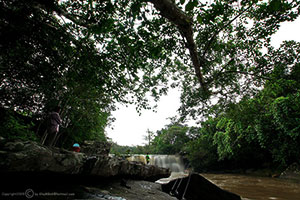
The main cascade is approximately 14 metres wide and 10 metres high. Instead of dropping as a narrow vertical column from a very high cliff, the water spreads over a broad rock shelf and descends across a wide section of sandstone. During periods of abundant water, a white curtain covers much of the ledge. When the flow is lower, visitors can see the rock layers, channels, joints, and uneven surfaces that control the direction of the water.
Below the main drop, the stream continues through rocky rapids and natural pools formed by long-term erosion. Some surfaces appear flat and accessible, while other areas contain deep cracks, hidden holes, sharp changes in level, and underwater cavities. Visitors should never jump from the ledges, enter prohibited pools, or attempt to cross a strong current. Water that appears shallow from above may conceal slippery stone, submerged gaps, or circulating currents.
Kaeng Pho is commonly described as a waterfall with water throughout the year, although the volume and strength vary significantly with the season, rainfall in the upper watershed, and weather conditions on the day of the visit. The rainy season produces the broadest and strongest cascade and the greenest forest. It is also the period of greatest flash-flood risk. Late rainy season and early cool season often provide a useful balance of attractive water levels, greener vegetation, and safer trail conditions.
The watercourse is connected to the Nam Phung watershed, an important drainage system in the Phu Phan landscape. The forest receives rainfall, slows surface runoff, stores moisture in soil and vegetation, and releases water into streams. Forest condition therefore directly affects the volume, clarity, and seasonal stability of the water. When an upper watershed is damaged, rainwater reaches streams more quickly, carries more sediment, erodes the soil, and increases the possibility of sudden flooding.
The exposed rock belongs to the Khorat Group and is associated with brown sandstone of the Sao Khua Formation. Layers with different levels of hardness have been eroded over a long period. More resistant sandstone remains as the waterfall ledge, while weaker sections have been worn down to form the drop, channels, rapids, and pools. This geological process continues gradually, meaning the detailed shape of the waterfall is always changing through natural weathering and erosion.
The rocks may appear brown, dark red, grey, or almost black according to mineral composition, moisture, and biological growth. After rain, the colours become deeper and more reflective. Thin algae and organic films can also make the surfaces extremely slippery. Secure shoes with good grip are essential, and visitors should avoid sloping ledges and exposed edges even when searching for a better photograph.
The surrounding dry dipterocarp forest is adapted to a pronounced dry season and relatively low water-retention soils. Many trees have thick bark, durable wood, and deciduous leaves. During the dry months, the landscape becomes open and golden brown, revealing more of the sandstone terrain. When the rains return, new leaves develop quickly, seasonal plants emerge from the forest floor, and the entire area turns green within a relatively short period.
Mixed deciduous forest occurs alongside the dry dipterocarp sections, particularly in areas with deeper soil and greater moisture. This forest has a more varied canopy, with deciduous trees, shrubs, vines, and lower vegetation growing together. Conditions near the stream are more humid than those on exposed ridges. The contrast along the trail shows how altitude, slope, soil, rock, and water availability influence vegetation communities.
The forest provides habitat for birds, insects, butterflies, reptiles, amphibians, and small mammals. Travelers are more likely to hear wildlife moving or calling than to see it clearly. Walking quietly, avoiding loud music, and remaining on the trail improves the possibility of observing natural behaviour while reducing disturbance to feeding, nesting, and breeding activity.
The Kaeng Pho nature trail is approximately 2,000 metres long and introduces visitors to the forest, stream, rock formations, and terrain around the waterfall. Walking time depends on trail conditions, moisture, physical fitness, and the number of stops made for observation or photography. A continuous walk may take approximately one to two hours, while families, school groups, photographers, and older travelers should allow additional time.
Although a two-kilometre trail may not sound demanding, it is different from walking on a paved road. Natural conditions can include wet soil, loose stones, exposed roots, leaf litter, slopes, and small stream crossings. Closed shoes or hiking footwear are more suitable than sandals. Visitors should carry drinking water, personal medication, rain protection, and a bag for taking all waste out of the forest.
The opening section generally connects the parking or ranger area with the forest. Traffic and village sounds gradually disappear as the route enters deeper shade and the sounds of insects and flowing water become stronger. Travelers should follow official signs, trail markings, and ranger instructions. Leaving the route or creating shortcuts damages ground vegetation, exposes soil, and encourages further erosion.
The main waterfall zone is the principal viewpoint. From a secure position, visitors can see the broad ledge, descending water, and pool in a single composition. When the flow is strong, the noise can dominate the area and spray may reach the surrounding rocks. Visitors should stand only on stable ground, avoid overcrowding the edge, and keep the walking route clear for other people.
The downstream rapid zone consists of rock shelves and channels extending from the principal cascade. It is an excellent place to observe how running water follows fractures and differences in rock resistance. It is also one of the most slippery and uneven parts of the site. Access should be limited to areas opened by the rangers. Ropes, barriers, warning signs, or temporary closures must never be crossed.
The forest and nature-study zone should be approached as a living classroom rather than a route to complete as quickly as possible. Visitors can observe bark, leaf shapes, seeds, fungi, animal traces, and changes in the soil. Flowers, stones, seeds, insects, and other natural objects should remain where they are. Even material that appears common may play an important role in forest regeneration and nutrient cycling.
A designated recreation and camping zone is available near the waterfall. The presence of an open natural area does not allow visitors to pitch tents wherever they choose. Overnight guests must register, pay the applicable camping or service charges, and follow regulations concerning noise, cooking, lighting, waste, and access times.
Anyone planning to stay overnight should contact Phu Pha Yon National Park before departure to confirm that the campground is open, check weather conditions, and learn whether any safety restrictions apply. Rangers may suspend camping during severe rain, flooding, storms, fire danger, or maintenance. Advance confirmation prevents travelers from arriving with equipment only to find that overnight use has been temporarily restricted.
Camping equipment should be suitable for forest humidity and changing weather. A tent should have a waterproof groundsheet and rain fly, while pegs should be appropriate for the surface. Each person should carry a torch and spare batteries. Nights in the mountain area can become cooler than the lowland towns, even outside the main cool season, so a light blanket and long-sleeved clothing are useful.
Cooking is permitted only in the zone and manner specified by the park. A controlled portable stove is safer than an open fire. Campfires must not be built on the forest floor, and visitors must not cut fresh branches or collect dry wood. Dry dipterocarp forest is vulnerable to fire during the dry season, and apparently extinguished embers can reignite when exposed to wind.
Food should remain in sealed containers, and no scraps should be left beside tents. Wildlife must never be fed. Food odours attract insects, rodents, and other animals, while feeding changes natural behaviour and encourages wildlife to approach people. This creates problems for both animals and campers.
Facilities at the waterfall are basic and reflect its remote natural setting. Travelers should obtain drinking water, meals, medicine, fuel, and personal supplies before entering the forest. Shops, restaurants, mobile signals, and emergency purchases may not be available at all times. Preparing in advance reduces repeated journeys and unnecessary packaging waste.
The most attractive period for abundant water and green forest generally extends from July to November. Months with frequent rain produce a wider cascade, but travelers must check park announcements immediately before visiting. Late rainy season and early cool season often provide strong water flow, improving trail conditions, and more comfortable temperatures for hiking and camping.
During the rainy season, safety decisions must consider weather in the upper watershed rather than only the sky directly above the waterfall. Flash floods can result from intense rain falling several kilometres upstream. Warning signs include rapidly darkening water, a sudden rise in level, branches and debris moving downstream, an unusual increase in noise, or an instruction from a ranger to evacuate. Visitors must move to higher ground immediately.
The cool season, generally from November to February, is suitable for camping and forest walking. Mornings and nights can be cool, the sky is often clearer, and the trail is usually less waterlogged than during the peak rains. The waterfall gradually becomes smaller as the dry season progresses, but the rock formations, forest structure, and peaceful environment remain rewarding.
During the hot and late dry season, the dry dipterocarp forest changes colour and sheds leaves. Areas that were shaded during the rains may become exposed to direct sunlight. Visitors should begin early, carry more drinking water, and avoid any activity that could produce sparks. Lower water levels can be valuable for travelers interested in geology because the sandstone layers and erosional channels become more visible.
The most practical time to begin a visit is between 08.00 and 10.00. Temperatures are lower and sufficient daylight remains for the nature trail. Travelers arriving later in the afternoon should calculate the remaining time carefully. A long walk should not begin close to the 16.00 closing time, because light fades earlier beneath the forest canopy and roots, holes, and wet rocks become harder to see.
Activities include waterfall viewing, nature walking, photography, bird observation, picnicking in permitted areas, and registered camping. Swimming is allowed only in a zone and under conditions approved by the rangers on that day. Visitors should ask whether the current is safe, whether a flotation device is required, and whether any pools have been closed. Old photographs or reviews do not confirm present conditions.
Photography requires particular care. Spray can wet lenses and phones, while slippery stone can cause equipment to fall. A wrist strap, neck strap, and waterproof bag are useful. Tripods should be placed only on stable ground. Photographers must never step backward without checking the surface or enter a current to obtain a lower angle.
Morning light is generally soft and brings out the green colour of the forest. After rain, wet stone appears darker and more saturated, although it also becomes more dangerous. Slow-shutter photography can create a smooth appearance in the water, but the camera should be operated from a secure viewpoint rather than from the middle of the stream.
Families with children should begin with the main viewing area near the parking zone. Children must remain within reach of an adult whenever they are close to water and should not run on rock shelves. Whether a child should attempt the entire two-kilometre trail depends on age, fitness, heat, and trail conditions. Turning back when a child becomes tired is safer than forcing the group to complete the route.
Older travelers and people with knee or mobility difficulties should ask the rangers about trail conditions before starting. Roots, wet rock, slopes, and uneven ground may occur. The waterfall does not provide complete wheelchair access throughout the natural area. A less demanding visit can focus on the main cascade and recreation area without completing the entire trail.
Solo travelers should inform a ranger or trusted person of their intended route and expected return time. They should not enter unmarked forest or separate from the official trail. Offline maps, the park telephone number, a whistle, torch, and power bank provide useful backup where mobile reception is weak.
Everything carried into the forest should be carried out again. Food waste, tissues, plastic bottles, cans, batteries, and packaging must not be burned or buried. Wildlife can uncover buried rubbish, and chemicals can contaminate the soil and stream. Reusable food containers and water bottles substantially reduce waste.
Bathing, washing hair, or cleaning dishes with soap directly in the stream is inappropriate. Even products marketed as biodegradable can affect aquatic organisms. Water and washing facilities should be used according to park regulations, and wastewater must be managed away from the natural stream.
Ban Na Hin Kong and other communities in Kok Tum Subdistrict form an important part of the route. Travelers pass homes and agricultural land before reaching the forest. Vehicles should slow down, avoid unnecessary horn use, and never block houses or farm access. Buying drinking water, food, or local products from community businesses helps distribute tourism income.
Visitors should respect privacy and local life. Close photographs of residents and homes require permission, while agricultural and private land should not be entered. Courteous tourism encourages local communities to support conservation and welcome responsible travelers.
Getting There from Dong Luang District Office generally involves Highway 2287 toward Kok Tum Subdistrict and Ban Na Hin Kong. The road distance is approximately 88 kilometres according to the route used. Navigation should be combined with local signs and current information from the park. Fuel, water, and essential supplies should be obtained before leaving the main district area.
From Phu Pha Yon National Park headquarters, follow Prem Phatthana Road and turn near Ban San Wae before continuing through Ban Na Hin Kong. The route is approximately 32 kilometres. Travelers staying near the park headquarters or visiting Huai Huat Reservoir can use this approach. Road conditions in the final section should be confirmed with the rangers, especially after sustained rain.
A private or rented vehicle is the most practical form of transport. Tyres, brakes, fuel, and the spare wheel should be checked before departure. A vehicle with greater ground clearance may be more convenient during wet conditions, but it must never be driven through moving water or beyond a ranger closure.
Public transport to the waterfall is limited, and no regular bus delivers passengers directly to the site. Travelers arriving by intercity bus should arrange a hired vehicle from Dong Luang or another nearby town and agree on the return time in advance. There may be no vehicle available to call from the waterfall.
An offline map, coordinates 16.7563, 104.2473, and the park contact numbers should be stored before departure. Mobile reception can disappear in valleys and behind ridges. Online navigation should not be the only guide; travelers should follow official signs and avoid minor unmarked tracks.
A practical day trip begins early enough to reach the waterfall near opening time. After registering, visitors can view the main cascade and walk the nature trail in the morning, eat a prepared lunch in a permitted zone, and leave before late afternoon. This avoids driving on unfamiliar mountain roads after dark.
An overnight itinerary requires advance registration. Arriving before midday allows sufficient daylight for checking the campground and pitching the tent. Visitors can explore the waterfall and part of the trail in the afternoon, return to camp within the park schedule, and continue to Huai Huat Reservoir or another national park attraction the following morning.
Nearby places that can be combined with Kaeng Pho include Wat Pa Phu Mai Hao, Huai Huat Reservoir, Kham Nam Sang Waterfall, Pha Phueng Waterfall, and the Phraya Tao Ngoi monument. These attractions lie in different sections of the mountain region, and travel time can be considerable. A schedule should allow for road conditions, park closing times, and unhurried walking.
Huai Huat Reservoir lies near the Phu Pha Yon National Park headquarters and provides a more open landscape than the narrow forest stream at Kaeng Pho. Visitors staying near the headquarters can explore the reservoir and its nature route before driving to the waterfall along Prem Phatthana Road.
Kham Nam Sang Waterfall is another important cascade within the national park and requires a forest walk from the headquarters area. Pha Phueng Waterfall is more seasonal and combines forest and sandstone-cliff scenery. Rangers should be asked about current water and trail conditions before adding either location to an itinerary.
The Phraya Tao Ngoi monument in Tao Ngoi District, Sakon Nakhon, is a cultural and faith-based attraction that can be included in a wider Phu Pha Yon route. Tao Ngoi also has a greater concentration of cafés, restaurants, and accommodation than the immediate waterfall area, making it a practical place for meals, supplies, or an overnight stay.
Kaeng Pho functions as an outdoor classroom demonstrating the relationship between forest, water, and rock. The forest receives rainfall, streams collect water from higher ground, and sandstone controls the form of the cascade and rapids. Protecting an upper watershed therefore preserves not only trees but also water resources, biodiversity, geological features, and the safety of downstream communities.
For schools and youth groups, the two-kilometre trail can support lessons in forest ecology, plant adaptation, the water cycle, rock weathering, erosion, and waste management. Group visits should be coordinated in advance, with sufficient supervisors and minimal noise. Education should not leave damaged vegetation, rubbish, or disturbed wildlife behind.
Phu Pha Yon National Park, under Thailand’s Department of National Parks, Wildlife and Plant Conservation, is the principal caretaker. Rangers monitor visitor safety, trails, camping, forest fire risk, and weather. They may close a route or suspend access during heavy rain, flooding, fire danger, maintenance, or another unsafe condition. Instructions issued on the day of travel take priority over normal opening information.
Admission to Phu Pha Yon National Park is 20 baht for a Thai adult and 10 baht for a Thai child. The foreign visitor rate is 100 baht for an adult and 50 baht for a child. Children under three, monks, religious personnel, eligible Thai senior citizens, and people with disabilities are exempt according to park regulations. Camping space, tent hire, and other services are charged separately.
Kaeng Pho is currently included among the national park attractions operating under normal visiting arrangements. Nevertheless, rangers may prohibit swimming, close the trail, suspend camping, or stop all entry immediately when water changes colour, rainfall becomes severe, or flash-flood risk increases. Travelers should telephone the park before departure and check current announcements again on the morning of the visit.
The attraction of Kaeng Pho extends beyond its measurements of 14 metres wide and 10 metres high. The complete experience includes driving through rural communities, entering dry dipterocarp and mixed deciduous forest, following the Nam Phung watershed, walking the nature trail, and observing how water has shaped sandstone over time. Travelers who prepare carefully, respect ranger instructions, and leave no trace can experience a quiet and ecologically important side of Mukdahan that differs greatly from the province’s urban and Mekong River attractions.
| Name | Kaeng Pho Waterfall |
| Thai Name | น้ำตกแก่งโพธิ์ |
| Location | Moo 8, Ban Na Hin Kong, Kok Tum Subdistrict, Dong Luang District, Mukdahan Province |
| Address | Ban Na Hin Kong, Moo 8, Kok Tum, Dong Luang, Mukdahan 49140, Thailand |
| Coordinates | 16.7563, 104.2473 |
| Protected Area | Phu Pha Yon National Park |
| Caretaker | Phu Pha Yon National Park, Department of National Parks, Wildlife and Plant Conservation |
| Waterfall Dimensions | Approximately 14 metres wide and 10 metres high |
| Waterfall Character | A broad cascade spreading over a sandstone ledge into rocky rapids and natural pools |
| Watershed | Nam Phung watershed and tributary streams of the Phu Phan forest |
| Geology | Brown sandstone of the Sao Khua Formation in the Khorat Group, eroded into a ledge, channels, rapids, and pools |
| Forest Types | Dry dipterocarp and mixed deciduous forest along the Nam Phung watercourse |
| Nature Trail | Approximately 2,000 metres; allow about 1–2 hours depending on trail conditions and fitness |
| Main Areas And Zones | 1. Registration and parking area 2. Main waterfall viewpoint 3. Downstream rapids and pool zone 4. 2,000-metre nature trail 5. Recreation and picnic area 6. Designated camping zone |
| Activities | Nature viewing, hiking, photography, bird observation, forest and geology study, picnicking, and registered camping |
| Open Days | Daily |
| Opening Hours | 08.00 – 16.00 |
| Admission Fees | Thai visitors: Adult 20 baht, Child 10 baht Foreign visitors: Adult 100 baht, Child 50 baht Exemptions apply to children under three, monks, eligible Thai senior citizens, and people with disabilities under park regulations. |
| Camping | Camping is available in the designated area. Registration and advance confirmation with the national park are required. |
| Facilities | Parking, ranger presence, natural walking route, recreation area, and camping zone. Facilities are basic, so visitors should bring sufficient food, water, and personal supplies. |
| Best Visiting Period | July–November for stronger water and green forest; November–February for cooler hiking and camping conditions |
| Safety | Flash floods, slippery sandstone, underwater gaps, and circulating currents are possible. Do not jump from rocks, cross barriers, or enter water without ranger approval. |
| From Dong Luang | Follow Highway 2287 toward Kok Tum and Ban Na Hin Kong; approximately 88 km depending on the route. |
| From The National Park Headquarters | Follow Prem Phatthana Road, turn near Ban San Wae, and continue through Ban Na Hin Kong for approximately 32 km. |
| Current Status | Open under normal national park visiting arrangements. Rangers may temporarily prohibit swimming, close trails, suspend camping, or stop entry during heavy rain or unsafe conditions. |
| Main Contact Numbers | Phu Pha Yon National Park: +66 42 707 214 and +66 83 835 9096 |
| Official Page | https://www.facebook.com/61550861694407/ |
| Nearby Tourist Attractions | 1. Wat Pa Phu Mai Hao, approximately 9 km 2. Huai Huat Reservoir and Phu Pha Yon National Park Headquarters, approximately 32 km, Tel. +66 83 835 9096 3. Kham Nam Sang Waterfall, approximately 34 km, Tel. +66 83 835 9096 4. Pha Phueng Waterfall, approximately 35 km, Tel. +66 83 835 9096 5. Phraya Tao Ngoi Monument, Tao Ngoi District, approximately 40 km |
| Nearby Restaurants | 1. Jib Kɑfæ Cafe, Tao Ngoi, approximately 38 km, Tel. +66 93 696 2922 2. Metta Cafe, Tao Ngoi, approximately 40 km, Tel. +66 95 663 5655 3. Café Amazon, Khao Wong Branch, approximately 45 km, Tel. +66 95 629 5740 4. Tiń Cafe Mukdahan, Dong Luang route, approximately 70 km 5. Jungle Cafe, Dong Luang Branch, approximately 88 km, Tel. +66 92 990 6995 |
| Nearby Accommodations | 1. Kaeng Pho Waterfall Campground, 0 km, Tel. +66 83 835 9096 2. Phu Pha Yon National Park Accommodation And Campground, approximately 32 km, Tel. +66 42 707 214, +66 83 835 9096 3. Goodville Resort Tao Ngoi, approximately 38 km, Tel. +66 92 462 2263, +66 88 334 4600 4. Tao Ngoi Resort, approximately 40 km, Tel. +66 86 631 9289 5. Good View Tao Ngoi, approximately 41 km, Tel. +66 83 326 1847 |
Frequently Asked Questions (FAQ)
Q: Where is Kaeng Pho Waterfall located?
A: It is located in Moo 8, Ban Na Hin Kong, Kok Tum Subdistrict, Dong Luang District, Mukdahan Province, within Phu Pha Yon National Park.
Q: What are the opening hours?
A: The waterfall is normally open daily from 08.00 to 16.00. Rangers may temporarily close the site during heavy rain, flash-flood risk, or another unsafe condition.
Q: How much is the admission fee?
A: The Phu Pha Yon National Park fee is 20 baht for a Thai adult and 10 baht for a Thai child. The foreign rate is 100 baht for an adult and 50 baht for a child.
Q: Does Kaeng Pho Waterfall have water throughout the year?
A: Water can flow throughout the year, but the volume changes with rainfall and season. The broadest flow is usually seen during the rainy season.
Q: Can visitors swim at Kaeng Pho Waterfall?
A: Swimming is permitted only in areas and under conditions approved by the rangers. Jumping from rocks, crossing barriers, and entering strong or discoloured water are prohibited.
Q: How long is the nature trail?
A: The nature trail is approximately 2,000 metres long and generally requires about one to two hours, depending on trail conditions and fitness.
Q: Is camping available?
A: Yes. A designated camping area is available, but visitors must register and confirm that the campground is open before travelling.
Q: What is the best season to visit?
A: July to November is suitable for stronger water flow and green forest. November to February offers cooler conditions for hiking and camping.
Category: ●Nature and Wildlife
Group: ●Waterfalls
Last Update : 2 MonthAgo