
lovethailand home >Northeastern Travel Attractions >Mukdahan Travel Attractions >Muang Mukdahan >Kham Pa Lai > Pratu Cave
TL;DR: Pratu Cave, Mukdahan attractions : Nature and Wildlife, Caves.

Pratu Cave
Open Days: Daily with advance coordination through Ban Na Kham Noi community
Opening Hours: There are no formally regulated opening hours. Visitors should enter between 06.00 and 17.00 and leave before darkness
Current Status: A small community-managed natural attraction. Travelers should contact Kham Pa Lai Subdistrict Municipality or local community leaders before visiting
Tham Pratu Cave, also known as Pha Tham Pratu, is situated on the ridge of Phu Hang near Ban Na Kham Noi in Kham Pa Lai Subdistrict, Mueang Mukdahan District. Its principal features are an extremely narrow cave entrance, an estimated depth of 30 metres, a steep cliff viewpoint overlooking the Phu Phan Range and a community forest containing mixed deciduous and dry dipterocarp vegetation. The cave formerly supported several bat species, but ordinary visitors should not crawl inside because the passage is confined and lacks standard safety infrastructure. The recommended experience is a guided daytime visit concentrating on the viewpoint, forest ecology and local community landscape.
Tham Pratu Cave is a small natural attraction on the ridge of Phu Hang near Ban Na Kham Noi, Kham Pa Lai Subdistrict, Mueang Mukdahan District, Mukdahan Province. It is not a large show cave with spacious chambers, installed lighting or constructed visitor paths. Its significance comes from a combination of natural and community features: a confined rock cavity, a dramatic viewpoint, community forest, historical bat habitat and the relationship between local residents and the resources of Phu Hang. It is most appropriate for travelers interested in quiet landscapes, community-based nature tourism and careful outdoor exploration.
The cave lies in the elevated terrain of Phu Hang. Its entrance is so narrow that a person cannot walk upright into the interior. Earlier explorers reportedly had to crawl through the opening, and the passage extends for approximately 30 metres. This physical form distinguishes Tham Pratu from developed caves equipped with stairs, handrails, lighting and resident staff. It remains a natural confined space, and entry requires knowledge of the site, suitable equipment and an experienced local guide. A depth of only 30 metres should never be interpreted as meaning that the cave is easy or safe for an unprepared visitor.
The Thai name “Tham Pratu” means “Door Cave” and reflects the small opening resembling a narrow doorway into the rock. From outside, the opening may appear large enough to enter, but the ceiling and internal passage remain low. Moving through such a confined space makes turning around and assisting another person difficult. Panic, injury, equipment failure or a displaced stone could complicate an exit. Ordinary travelers should therefore view the entrance from a safe external position and should never enter without local authorization and expert supervision.
The cave was historically known as a habitat for several species of bats. These animals used its darkness and relative isolation as a daytime roost before leaving to feed during the evening and night. Local residents formerly collected accumulated bat guano for use as fertilizer in vegetable gardens and agricultural land. This history demonstrates a practical relationship between the cave ecosystem and the community. Contemporary use, however, should prioritize the protection of bats and the cave environment rather than repeated extraction of natural material.
Bats contribute to the ecology of Phu Hang in several ways. Some species help control nocturnal insects, while others may contribute to seed dispersal or pollination. Keeping the cave undisturbed therefore supports both the forest and nearby agricultural landscapes. Visitors must not shout, direct powerful lights continuously into roosting areas or use repeated flash photography. Disturbance can force bats to fly unnecessarily, consume energy or abandon an established roost.
No bat or other wild animal should be touched. An animal found on the cave floor or appearing motionless should not be handled by an untrained visitor. Touching wildlife can injure both the person and the animal. Travelers should record the location from a safe distance and notify community leaders or the local authority. Food and water must not be placed inside the cave, and an injured animal should not be removed without qualified assistance.
Accumulated bat guano was once valued as a natural fertilizer, but visitors must not walk through, dig or collect material from the cave floor. Disturbing dry deposits can release dust inside a confined area and permanently alter the cave surface. No soil, guano, rock or biological material should leave the cave without formal authorization for an approved study. Responsible tourism requires the site to remain unchanged.
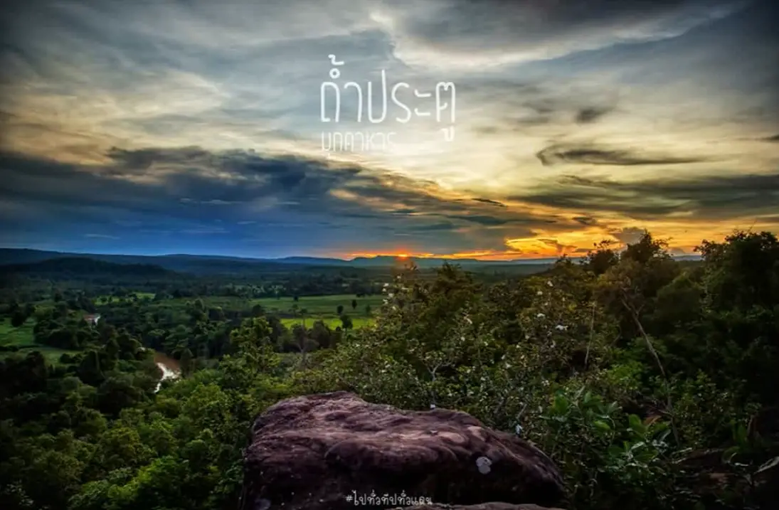
The viewpoint is as important as the cave itself. A steep cliff on the Phu Hang ridge overlooks the Phu Phan Range and the rural landscape below. On a clear day, visitors can see Ban Sam Kha, Ban Kaeng and parts of Kham Pa Lai Subdistrict. Forest, farmland, villages and distant ridges combine to create a broad view representing the countryside of northern Mukdahan.
Early morning is generally the most rewarding period for the viewpoint. Temperatures are lower, sunlight is softer and mist may remain over lower ground during certain seasons. Side lighting defines the ridges and terrain more clearly than harsh midday light. Anyone planning to arrive before sunrise must arrange a local guide because junctions, uneven ground and the cliff edge are difficult to see in darkness.
The period from approximately 08.00 to 10.30 is suitable for forest observation and photography. There is sufficient light to identify the route, while temperatures are normally manageable. Afternoon light provides a different perspective across the landscape, but visitors must reserve enough time to return before darkness. Waiting for sunset without a knowledgeable guide or a confirmed return plan is unsafe.
The cliff viewpoint does not have the standard protective railings found at a fully developed tourist attraction. Visitors must remain well back from the edge, avoid projecting rocks and never walk backward while taking photographs. A wide-angle lens can capture the landscape without requiring the photographer to approach the drop. Risky posing is dangerous and also encourages unsafe imitation by other visitors.
Wind on the ridge can be considerably stronger than in the village below, particularly before storms and during the cool season. Hats, umbrellas, tripods and light equipment can destabilize a person near the cliff. All belongings should be secured, umbrellas should remain closed near exposed areas and bags must not be placed on sloping surfaces. When wind makes standing difficult, visitors should move inland toward level ground and trees.
Parts of the Phu Hang ridge are relatively level and densely vegetated. The forest includes mixed deciduous and dry dipterocarp communities whose appearance changes with soil, moisture and season. Mixed deciduous forest contains several tree species growing together, while dry dipterocarp forest is associated with drier, shallower ground. Many trees lose their leaves during the dry season and produce new foliage after the rains begin.
Ban Na Kham Noi Community Forest joined Thailand’s community forest program in 2000. It covers approximately 475 rai and 2 ngan within the Dong Mu National Reserved Forest. This status demonstrates the community’s long-term role in forest-fire surveillance, watershed protection, management of local resource use and the transfer of ecological knowledge. A journey to Tham Pratu should therefore follow community-forest principles and respect locally established rules.
Dry dipterocarp forest can appear open during the dry season, but it is not empty land available for unrestricted walking. Seedlings, grasses, fungi, insects and small organisms occupy the forest floor. Leaving the route damages plants and accelerates erosion, particularly on slopes. When many visitors follow an informal shortcut, the resulting line can become a drainage channel during rain and continue eroding the soil.
The rainy season transforms Phu Hang into a green and humid landscape. Trees develop new leaves, fungi emerge and views from the cliff become intensely green. At the same time, soil and stone become slippery, water may cross the access route and storm clouds can surround the ridge rapidly. Travel should be postponed during thunderstorms or prolonged heavy rainfall.
Lightning is a major danger on a ridge and exposed cliff. Dark clouds, thunder or a sudden change in wind require an immediate retreat from exposed ground. Visitors must not shelter beneath an isolated tall tree or raise metal equipment. They should not wait for rain to begin before returning. Weather forecasts are useful, but conditions visible on the mountain must always guide the final decision.
The cool season from approximately November to February is normally the best period for walking and sightseeing. Temperatures are lower and paths are usually drier than during the rains. Mist and cool air may occur in the morning, so a light layer is useful. Dry weather does not eliminate the need for drinking water, as walking uphill still causes dehydration.
March to May is hot and dry. Dry dipterocarp trees lose leaves, direct sunlight reaches the ground and forest-fire risk increases. Smoking, candles, incense and cooking fires are inappropriate anywhere on Phu Hang. Glass containers and objects capable of producing sparks must not be left behind. When the community or municipality closes the forest for fire prevention, the closure must be obeyed.
Birds, squirrels, reptiles, insects and other small forest animals may be encountered around Phu Hang. Sightings depend on season, time and visitor noise. Early morning normally provides more opportunities to hear birds than busy periods. Birdwatchers should use binoculars, maintain distance and avoid prolonged playback of recorded calls.
Wildlife must not be fed, and food waste must not remain on the ridge. Human food can be unsuitable for animals and may teach them to approach people. Once natural caution is lost, wildlife becomes more vulnerable to vehicles, dogs and conflict. Removing leftovers is therefore an act of wildlife protection as well as basic cleanliness.
A small monastic retreat or forest meditation area is located behind Phu Hang. It is a place of religious practice rather than a recreational facility. Visitors should dress respectfully, speak quietly, avoid music and request permission before photographing monks or residential areas. Religious activity must be given priority, and people should not enter private monastic zones.
The presence of a monastic retreat reflects the value of the mountain as a place of silence and contemplation. Forest and elevation reduce disturbance from the settlement below. Travelers can support this atmosphere by walking quietly, removing rubbish, respecting private spaces and requesting permission before using water, toilets or other facilities associated with the retreat.
The site can be understood as several functional areas: Ban Na Kham Noi community and the coordination point, the designated parking area, the Phu Hang access route, the monastic retreat, the ridge and nature path, the cliff viewpoint and the cave entrance. Boundaries are not marked with complete fences or signs. Visitors should therefore follow a local guide rather than choosing a route from footprints alone.
Ban Na Kham Noi is the appropriate starting point. Visitors should report to community leaders or a coordinator to confirm road conditions, weather, parking and restrictions. The village is a living community with homes, a school, agricultural land and daily traffic. Vehicles must not obstruct homes, farm access or emergency routes.
Parking is available only in areas identified by the community or close to the approved mountain route. Vehicles can travel relatively close to the viewpoint, but not every vehicle can reach the same position throughout the year. The final road changes with rainfall, erosion and maintenance. Low-clearance cars should obtain advice before traveling, while motorcycles require caution on loose gravel and steep sections.
Some sections toward the ridge may be drivable, while others require walking. Drivers must travel slowly, yield to community vehicles and remain on the established road. Driving onto vegetation to avoid a rut or create a new parking position damages the forest edge. When wet ground is soft, postponing the trip is preferable to becoming stuck and creating deeper erosion during recovery.
Walking on the ridge requires secure footwear with reliable tread. Smooth sandals are unsuitable for rock, roots and gravel. Long trousers help protect against branches and insects. Each traveler should carry drinking water, regular medication, a small first-aid kit and a flashlight. A flashlight remains useful even when the group plans to leave early because thick cloud or an emergency can delay the return.
The viewpoint has limited safe space. Large groups should not gather close to the cliff, and tents should never be placed in exposed wind or across a route. When the community offers organized camping, participants must use designated areas and comply with rules concerning fire, waste, water and quiet hours. Old photographs or social posts do not authorize independent camping.
Access to the cave entrance must be controlled, particularly for children, older travelers and anyone unfamiliar with confined environments. The narrow opening can produce anxiety or panic. A distressed person may move in the wrong direction or obstruct the only exit. There is no installed lighting, handrail or standardized emergency route. Viewing the entrance from outside remains the safest option.
The cave must never be entered during or immediately after heavy rain. Water can pass through cracks and lower points even though the entrance is on a ridge. Moisture makes rock slippery and can soften soil or move loose material. Conditions inside cannot be judged visually by an untrained visitor without appropriate equipment.
Authorized cave exploration requires a helmet, primary and backup lights, protective clothing, gloves and secure footwear. A person must remain outside, and a firm return time must be established. No one should enter alone or send a large group into a narrow passage. Ordinary tourism should focus on the outside environment; internal exploration belongs only to approved activities under experienced supervision.
Photography at the entrance should avoid continuous flash and intense lighting directed into the cave. Cameras should have straps, and photographers should not stand on unstable rocks. Rock, branches and guano must not be moved to improve a composition. A responsible photograph records the site without changing it.
Drone use requires consideration of aviation law, community privacy, the meditation area and wildlife. Flights should not take place near the cave, above monks or directly over visitors. Noise may disturb bats and birds. Commercial photography and filming require advance permission from the community and relevant authorities.
Families with children should concentrate on safe viewpoints and forest learning rather than cave entry. Children must remain within immediate reach and must never run near the cliff. Before ascending, adults should explain that no one may separate from the group, throw stones, handle animals or leave rubbish.
Older visitors may be able to travel by vehicle close to the viewpoint when the road is suitable. Uneven ground, slippery stone and the absence of handrails still require caution. A level point well back from the cliff may be more appropriate than walking to the cave. A walking stick, folding chair, water, medication and a supportive companion are useful.
People uncomfortable with heights can view the Phu Phan landscape from an inland position with trees and level ground. Approaching the cliff edge is unnecessary. Anyone with a fear of confined spaces or a history of panic should not test the cave entrance, even with companions, because movement in a narrow passage can trigger severe distress and complicate assistance.
Solo travel is inappropriate because the site has no continuously staffed visitor center. Visitors should arrive as a group, share the itinerary with another person and use a community guide. Phones should be fully charged and supported by a power bank, although signal coverage can vary behind the ridge and inside rock cavities.
Recommended supplies include drinking water, snacks, a hat, sunscreen, insect repellent, a rain layer, suitable shoes, basic first aid and a rubbish bag. Glass, alcohol, fire-making equipment and loudspeakers should remain outside the site. Belongings should be secured in a closed backpack so that both hands remain available for balance.
Visitors must carry sufficient drinking water from the village because no shop or reliable water station operates on the ridge. Water from a natural pool should not be consumed directly. Food should be simple and low-waste. Every piece of packaging and every leftover must leave with the group.
Fruit peel, seeds and organic food must not be discarded in the forest. Introduced plant material may spread outside its original area, and food smells attract wildlife to tourist sites. Tissues and cigarette ends must also be removed. Hiding rubbish beneath a rock is not responsible disposal.
Writing, carving and painting on the cave entrance, cliff, trees or rocks are prohibited. Small marks remain for years and encourage further damage. Visitors should not build stone piles, tie ribbons to trees or leave route markers. A local guide or recorded coordinates should be used instead of foreign material.
Plants, fungi, flowers, seeds, insect nests, stones and guano must not be collected unless part of an authorized study. Repeated removal by visitors depletes natural resources. Even fallen branches and decaying logs provide habitat and return nutrients to the forest floor.
Smoke, fire or a burning smell requires an immediate departure and a report to the community or municipality. Visitors should not approach a forest fire for photography or attempt to control a large fire. Wind can change fire direction rapidly on the ridge, while smoke can hide paths and impair breathing.
If someone slips, becomes dizzy or suffers an injury, the group should stop and secure the area before contacting the guide. A person with a suspected head, neck or bone injury should not be moved unless remaining in place creates immediate danger. Recording the location, route condition and number of injured people will assist an emergency response.
Getting There from Mukdahan city, follow Highway 212 north on the Mukdahan–That Phanom route for approximately 25 kilometres. At Kham Pa Lai Subdistrict, turn left onto the road connecting Kham Pa Lai with Kan Lueang Dong in Dong Luang District. Continue approximately 6 kilometres into Ban Na Kham Noi and coordinate with the community before proceeding toward Phu Hang and Tham Pratu.
The route from Mukdahan city to Kham Pa Lai follows a paved national highway and is straightforward by car or motorcycle. After turning into Ban Na Kham Noi, the road becomes a community route shared by residents, farm vehicles, motorcycles, children and domestic animals. Drivers must reduce speed and should not continue at highway speed inside the village.
Ban Na Kham Noi is Moo 6 of Kham Pa Lai Subdistrict and lies approximately 30 kilometres from central Mueang Mukdahan. Because villages with the same name exist elsewhere in Thailand, navigation should include the subdistrict and province. An offline map and the telephone number of Kham Pa Lai Subdistrict Municipality should be saved before departure.
A private car offers the greatest flexibility because it can reach the village and approach the mountain route. Fuel, tires, brakes and the spare tire should be checked. During the rainy season, ask about the final road because low-clearance cars may have difficulty with ruts or standing water. A recommendation to park below should always be followed.
Motorcycles can be used by experienced riders. Helmets and closed footwear are essential, and luggage should remain light. Riding uphill during rain or after dark is not recommended because headlights provide limited visibility around bends and uneven surfaces. Traveling with another vehicle provides assistance if a mechanical problem occurs.
Public transport users can take a vehicle operating on the Mukdahan–That Phanom route and disembark near Kham Pa Lai. A local transfer must then be arranged to Ban Na Kham Noi and Phu Hang. The fare, waiting period and return pickup point should be agreed in advance because no scheduled service travels directly to Tham Pratu.
A half-day itinerary should leave Mukdahan city in the morning, reach Ban Na Kham Noi, meet a local guide and spend approximately 2–3 hours exploring the forest, viewpoint and external cave area. Lunch can follow in Kham Pa Lai or Wan Yai. This schedule allows sufficient time without remaining on the mountain near darkness.
A full-day journey can continue to Mano Phirom Beach, the Shrine of Our Lady of the Martyrs of Thailand at Song Khon or Kaeng Kabao. These Mekong River destinations contrast with the forested ridge and allow one day to include mountain ecology, community heritage, religious history and riverside scenery.
Travelers interested in local culture can learn about naturally dyed handwoven cotton associated with Ban Na Kham Noi. Advance coordination is required to determine whether a community group or demonstration is available. Visitors should not enter a producer’s home without an appointment. Direct purchases support local income and help preserve traditional skills.
Restaurants are not located on the ridge. They are distributed around Ban Sam Kha, Kham Pa Lai and Wan Yai. Travelers should eat or purchase essential items before ascending and should call in advance, particularly on weekdays. A small family business may close or change its hours according to supplies and household commitments.
The closest accommodation is distributed across Kham Pa Lai, Wan Yai and Mukdahan city. Staying around Kham Pa Lai or Wan Yai reduces the travel time required for an early visit. Mukdahan city provides a wider range of hotels, restaurants and services but requires an earlier departure. Reservations and telephone numbers should be confirmed before the journey.
Tham Pratu does not have a standard admission booth. Visitors should coordinate through the community. Guide, vehicle-transfer, food, camping or other community-service charges must be discussed directly before an activity begins. Fair payment supports trail maintenance, cleanliness and community forest conservation.
Facilities are limited. There is no major visitor center, installed cave lighting, commercial shop or rescue unit permanently stationed at the entrance. Access to toilets or water associated with the village or monastic retreat must be requested. Travelers should arrive self-sufficient and should not expect to purchase supplies on the ridge.
The site is suitable for travelers who understand community-based nature tourism and are willing to follow local rules. It is not suitable for untrained visitors attempting to crawl through the cave, groups expecting complete tourist facilities or events involving loud entertainment. Its genuine value lies in the landscape, cave ecology, bats, dry dipterocarp and mixed deciduous forest and community stewardship.
Quiet behavior and complete waste removal help bats and wildlife continue using Phu Hang. Following the path, reducing plastic and hiring a community guide reduce tourism impacts. Before leaving, visitors should inspect resting and parking areas and remove every trace of the visit.
Tham Pratu should not be treated merely as a challenge to crawl through a narrow opening or pose beside a cliff. It is a connected natural and cultural landscape containing a cave, forest, bats, historical use of guano, a monastic retreat and Ban Na Kham Noi community. A knowledgeable and cautious visit will help preserve Phu Hang as a viewpoint and outdoor classroom for Kham Pa Lai.
| Name | Tham Pratu Cave and Pha Tham Pratu Viewpoint |
| Thai Name | ถ้ำประตู / ผาถ้ำประตู ภูฮัง |
| Location | Phu Hang near Ban Na Kham Noi, Moo 6, Kham Pa Lai Subdistrict, Mueang Mukdahan District, Mukdahan Province, Thailand |
| Site Type | A small natural cave on a forested ridge with a narrow entrance and a steep cliff viewpoint |
| Cave Depth | Approximately 30 metres. The entrance is too confined for upright walking and requires crawling; entry is unsuitable without authorization and specialized supervision |
| Highlights | Narrow cave entrance, historical bat habitat and views of the Phu Phan Range, Ban Sam Kha, Ban Kaeng and the Kham Pa Lai landscape |
| Historical Community Use | Local residents formerly collected bat guano for use as fertilizer in vegetable gardens and agricultural land |
| Forest Environment | Mixed deciduous and dry dipterocarp forest in Ban Na Kham Noi Community Forest |
| Community Forest Area | Approximately 475 rai and 2 ngan; participating in the community forest program since 2000 within Dong Mu National Reserved Forest |
| Caretaker / Local Coordinator | Ban Na Kham Noi community and Kham Pa Lai Subdistrict Municipality |
| Main Contact Number | Kham Pa Lai Subdistrict Municipality: +66 42 643 058 |
| Monastic Retreat | A small monastic or meditation area lies behind Phu Hang. Visitors must remain quiet and avoid residential sections without permission |
| Open Days | Daily with advance community coordination and suitable weather conditions |
| Opening Hours | No officially regulated hours; recommended visiting time is 06.00 – 17.00, with departure before darkness |
| Fees | No standard ticket booth. Guide, transport, food, camping and community-activity charges should be confirmed in advance |
| Activities | Landscape viewing, photography, forest study, birdwatching, learning about cave and bat ecology and responsible community visits |
| Main Areas / Zones | 1. Ban Na Kham Noi community and coordination point 2. Community-designated parking area 3. Phu Hang access route 4. Monastic and meditation area 5. Ridge and nature route 6. Cliff viewpoint 7. Restricted cave-entrance area |
| Facilities | Community-designated parking and guide services by advance arrangement. No cave lighting, major visitor center, shop or permanent rescue unit at the entrance |
| Travel Information | Follow Highway 212 north from Mukdahan city toward That Phanom for approximately 25 km. Turn left at Kham Pa Lai and continue approximately 6 km to Ban Na Kham Noi before coordinating the final approach |
| Recommended Transport | Private car or motorcycle. Confirm the condition of the Phu Hang access road with the community during the rainy season |
| Safety | The cave is confined, the cliff is steep and unguarded, rocks may be slippery, ridge winds can be strong and dry-season fire risk is significant. Do not enter the cave or approach the cliff without local supervision |
| Nearby Tourist Attractions | 1. Ban Na Kham Noi Community Forest, approximately 2 km 2. Mano Phirom Beach, Wan Yai District, approximately 25 km 3. Shrine of Our Lady of the Martyrs of Thailand at Song Khon, approximately 28 km 4. Kaeng Kabao, Wan Yai District, approximately 32 km 5. Wat Phra That Phanom Woramahawihan, Nakhon Phanom Province, approximately 40 km 6. Ho Kaeo Mukdahan, approximately 42 km |
| Nearby Restaurants | 1. Champion World Moo Kratha, Kham Pa Lai Branch at Ban Sam Kha, approximately 13 km, Tel. +66 91 061 2960 2. 62 Garden Cafe, Wan Yai District, approximately 25 km, Tel. +66 42 620 718 3. Ben Ben Coffee, Wan Yai District, approximately 27 km, Tel. +66 88 357 2123, +66 95 659 9076 4. Khrour Wan Yai Cafe, approximately 28 km, Tel. +66 94 291 5979, +66 93 514 9569, +66 95 415 7822 5. Krua Mae Dara Pla Nam Khong, approximately 29 km, Tel. +66 91 704 7176 |
| Nearby Accommodations | 1. Suanpalm Healthy Resort, Kham Pa Lai, approximately 14 km, Tel. +66 84 321 8844 2. Baankiengsawan, Wan Yai District, approximately 27 km, Tel. +66 88 855 5464 3. Submukda Resort, Wan Yai District, approximately 29 km, Tel. +66 91 345 1819 4. Mukda Sawan Resort, approximately 36 km, Tel. +66 42 694 209, +66 89 861 4244 5. Bangrak Resort Mukdahan, approximately 38 km, Tel. +66 42 040 151 |
Frequently Asked Questions (FAQ)
Q: Where is Tham Pratu Cave located?
A: It is situated on Phu Hang near Ban Na Kham Noi, Moo 6, Kham Pa Lai Subdistrict, Mueang Mukdahan District. From Mukdahan city, follow Highway 212 toward That Phanom and turn into Ban Na Kham Noi.
Q: Is Tham Pratu open every day?
A: It is a community-based attraction without a formal entrance gate or regulated schedule. Travelers must coordinate through Ban Na Kham Noi community or Kham Pa Lai Subdistrict Municipality and visit only during daylight.
Q: Can ordinary visitors crawl inside the cave?
A: The entrance is extremely narrow, and the interior has no lighting, emergency route or standard safety system. Ordinary visitors should not enter. Exploration requires authorization and experienced local supervision.
Q: How deep is Tham Pratu Cave?
A: Local information describes the cave as approximately 30 metres deep. The confined entrance and crawling passage make entry more difficult than the distance suggests.
Q: What can visitors see from the viewpoint?
A: On a clear day, the cliff viewpoint overlooks the Phu Phan Range, Ban Sam Kha, Ban Kaeng, agricultural land and the wider Kham Pa Lai countryside.
Q: When is the best time to visit?
A: November to February normally provides the most comfortable walking and viewing conditions. Avoid heavy rain, thunderstorms, strong winds and any period when the community closes the forest for fire prevention.
Q: Is there an admission fee?
A: There is no standard ticket booth. Guide, local transport, food or community camping charges must be discussed and confirmed before the visit.
Q: Who should travelers contact for current access information?
A: Contact Kham Pa Lai Subdistrict Municipality at +66 42 643 058 to request local information and coordination with Ban Na Kham Noi community.
 Category: ●Nature and Wildlife
 Group: ●Caves
Last Update : 1 MonthAgo
 Last Update : 1 MonthAgo
 Click to Access the Navigation Map GPS
Pratu Cave Map
Recommend

 Art, Culture and Heritage
 Historical Sites and Monuments(2)
 Landmarks and Memorials(3)
 Art, Craft Centres, Tradition(2)
 Museums(1)
 Places of Worship
 Temple(17)
 Other Sacred Sites(3)
 Suburban Living
 Village, Community(4)
 Local Market(2)
 National Parks and Marine Reserves(4)
 Mountain (Doi)(5)
 Dam, Reservoir, Lake(3)
 Waterfalls(5)
Caves(2)
Waterfalls(5)
Caves(2)
 River, Canal(2)
 Bays and Beaches(1)
 Other natural attractions(1)
 Entertainment and Agricultural
 Farms, Parks and Ecotourism(1)


