
lovethailand home >Northeastern Travel Attractions >Mukdahan Travel Attractions >Dong Luang >Kok Tum > Huai Bang Sai
TL;DR: Huai Bang Sai, open Public riverside areas and community viewpoints can generally be accessed every, hours The watercourse has no entrance gate or official operating schedule. Visiting.

Huai Bang Sai
Open Days: Public riverside areas and community viewpoints can generally be accessed every day. Tha Kaeng Duea at Ban Phon Hai operates as a seasonal recreation area, depending on the water level, weather and announcements issued by Nong Khaen Subdistrict Municipality
Opening Hours: The watercourse has no entrance gate or official operating schedule. Visiting between 06.00 and 18.00 is recommended. Do not enter the water when it is high, discolored or fast flowing, or when a local warning is in force
Latest Status: Huai Bang Sai is a public natural watercourse passing through numerous communities. Recreational and swimming activities must be confirmed with the relevant municipality or community because access conditions change according to rainfall and water levels
Huai Bang Sai is one of Mukdahan Province’s important natural waterways. Originating in the Phu Phan mountain landscape, it flows through communities in Dong Luang and Mueang Mukdahan districts, including Nong Khaen, Ban Kan Lueang Dong, Ban Phon Hai, Ban Bang Sai Phatthana and Kham Pa Lai, before continuing through the lower basin and connecting with the Mekong River. The waterway supports scenery, forest ecology, agriculture, community fisheries, local culture and water management. This article uses Tha Kaeng Duea at Ban Phon Hai as the reference visitor point. It is a seasonal community recreation area, but swimming must be avoided during the rainy season or whenever the current becomes strong.
Huai Bang Sai Stream in Mukdahan Province is a major natural watercourse that has long influenced the province’s landscape, settlements and water resources. It passes through several districts, subdistricts and villages, particularly communities around Nong Khaen, Ban Kan Lueang Dong, Ban Phon Hai, Ban Bang Sai Phatthana and Kham Pa Lai. Because of its length and the number of communities along its route, Huai Bang Sai is not a single attraction with one entrance. It is a connected landscape containing headwater forests, reservoirs, agricultural areas, seasonal rapids, community bridges, riverbanks and a water-regulation structure near the lower basin before the stream reaches the Mekong.
Although the Thai word “huai” is commonly translated as a small stream, Huai Bang Sai is substantially larger and more important than a minor drainage channel. Irrigation documents describe the watercourse as approximately 90 kilometres long. Its section through Bang Sai Yai Subdistrict alone extends for around 24 kilometres and reaches an average width of approximately 80 metres in some areas. Its physical character changes continuously: narrow channels and reservoirs dominate the headwaters, forest and farmland surround the middle reaches, and the lower section becomes broader as it approaches the Mekong system.
The headwaters lie in the Phu Phan mountain area around Kok Tum Subdistrict and the uplands of Dong Luang District. Forested slopes receive rainfall before releasing it into smaller channels that gradually combine to form Huai Bang Sai. Tree cover slows surface runoff, reduces soil erosion, filters sediment and retains moisture. These natural processes allow water to reach lower communities for a longer period than it would if the headwater forest were extensively cleared.
The upper basin also contains the Upper Huai Bang Sai Basin Development Project under a royal initiative. It was created to address water shortages affecting residents of Kok Tum and neighboring areas. A group of reservoirs and water-management facilities stores rainy-season water for domestic use, farming, fisheries and environmental rehabilitation. Decisions made in the upper basin therefore influence the volume and seasonal balance of Huai Bang Sai farther downstream.
After leaving the headwaters, the stream crosses the varied landscape of Dong Luang District, including foothills, dry dipterocarp woodland, mixed deciduous forest, rice fields, rubber plantations, cassava fields, sugarcane and other agricultural land. This diversity gives each section a different appearance. Some reaches are shaded by trees, while others open onto broad fields. Shallow seasonal rapids and exposed banks appear where the water level falls, creating potential recreation areas when conditions are safe.
Nong Khaen Subdistrict is an important section of the watercourse. Huai Bang Sai passes through or near Ban Kan Lueang Dong, Ban Nong Khaen, Ban Phon Hai and Ban Bang Sai Phatthana. It functions as scenery, agricultural water, ecological habitat and a community recreation resource. Residents understand that its level changes significantly with the seasons and use local experience to plan farming, fishing and safe movement during periods of intense rain.
Ban Phon Hai, Moo 3, Nong Khaen Subdistrict, has a particularly close relationship with Huai Bang Sai. The community also manages forest and water resources associated with Huai Khaen and Huai Rai Reservoir. Local resource management therefore connects people, forest and water rather than treating them as separate subjects. Huai Bang Sai supports farming and fishing and forms part of the community’s settlement history and shared memory.
Part of the Ban Phon Hai population has Tai So, or Kaso, cultural roots, one of Mukdahan’s important ethnic communities. Local life is closely associated with forest, water, agriculture and seasonal customs. A visit to the Ban Phon Hai section of Huai Bang Sai can therefore provide an understanding of community adaptation, forest stewardship and careful use of natural water, rather than simply a view of the stream.
Tha Kaeng Duea is a riverside area at Ban Phon Hai that has received increasing attention during the hot season. Nong Khaen Subdistrict Municipality and the community have promoted it as a seasonal local recreation point. When the water becomes lower and slower, shallow rapids and accessible banks may appear, allowing visitors to sit, eat and enjoy the natural setting. Tha Kaeng Duea is not an engineered water park, however, and its water level cannot be controlled for tourism throughout the year.
This article uses Tha Kaeng Duea as the reference point for the distances shown in the summary table. It has clearer visitor information and community coordination than many other sections of Huai Bang Sai. All distances are approximate driving distances and may change according to the selected road, the precise starting point and seasonal road conditions.
During the hot season, generally from March to early May, the level in some sections declines and the current becomes slower than in the rainy months. Rapids, sandbars and riverside ground become more visible. The community may provide seating, temporary food services or small recreational facilities. This is normally the period with the greatest tourism potential, but visitors must still check before traveling because water levels vary from year to year and community services may not operate every day.
The rainy season, from approximately May to October, can produce rapid increases in the level and speed of Huai Bang Sai. Heavy rain in the Phu Phan headwaters enters numerous tributary channels and eventually reaches the main stream. Water can rise at Ban Phon Hai or Kan Lueang Dong even when no rain is falling locally. During this period, viewing should take place from high ground, an authorized bridge or another community-designated point, and swimming must be avoided when the current is strong.
Warning signs include a sudden increase in the sound of the water, discoloration, branches and debris moving downstream, continuous rising and water entering low banks. Anyone observing these signs must leave the stream immediately. Do not stop to retrieve nonessential belongings or photograph a flood. Vehicles should be moved from low ground, and no driver should attempt to cross a flooded road or bridge.
The cool season, from approximately November to February, offers comfortable weather for scenic drives and photography. Water levels gradually decline after the rains, although flow continues in many reaches, particularly where reservoirs and upper channels support the system. Light mist may form above farmland and the stream in the morning, creating good conditions for birdwatching and observing community life.
Many sections of Huai Bang Sai retain water throughout the year, but depth and current vary substantially. The rainy-season stream is high and fast, while the dry season exposes rapids, sand and land used for seasonal cultivation. Year-round water does not mean that every section is suitable for swimming or direct consumption. The stream passes through communities and agricultural land, and water quality changes with rainfall, sediment and human activity.
Untreated stream water should never be consumed, even when it appears clear. Microorganisms, fine sediment and other contamination may be invisible. Visitors should bring safe drinking and cooking water. Soap, shampoo, detergent and other cleaning products must not be used in the stream because they affect fish, aquatic organisms and downstream community water quality.
Riverside vegetation is essential to the health of the watercourse. Trees, shrubs, grasses and root systems stabilize the bank, filter sediment and reduce erosion. Overhanging vegetation shades the water and moderates its temperature, while roots and fallen wood provide shelter for fish, frogs, aquatic insects and smaller organisms. Clearing a bank or driving onto soft ground can therefore cause damage beyond the immediately visible area.
Sections passing through forest are generally cooler and more humid than open agricultural reaches. Leaves entering the water provide food for small organisms, which in turn support fish and other animals. This relationship makes the stream an ecological corridor connecting the Phu Phan headwaters with the lower basin. It should not be understood merely as a channel for carrying rainwater.
Fish and aquatic animals have supported community food systems and small-scale income for generations. Traditional fishing is particularly important when fish move between the Mekong, the lower basin and tributaries. Fishing must follow the law and local rules. Electricity, explosives, poison and destructive equipment must never be used because they kill juvenile fish, damage breeding habitat and endanger everyone using the water.
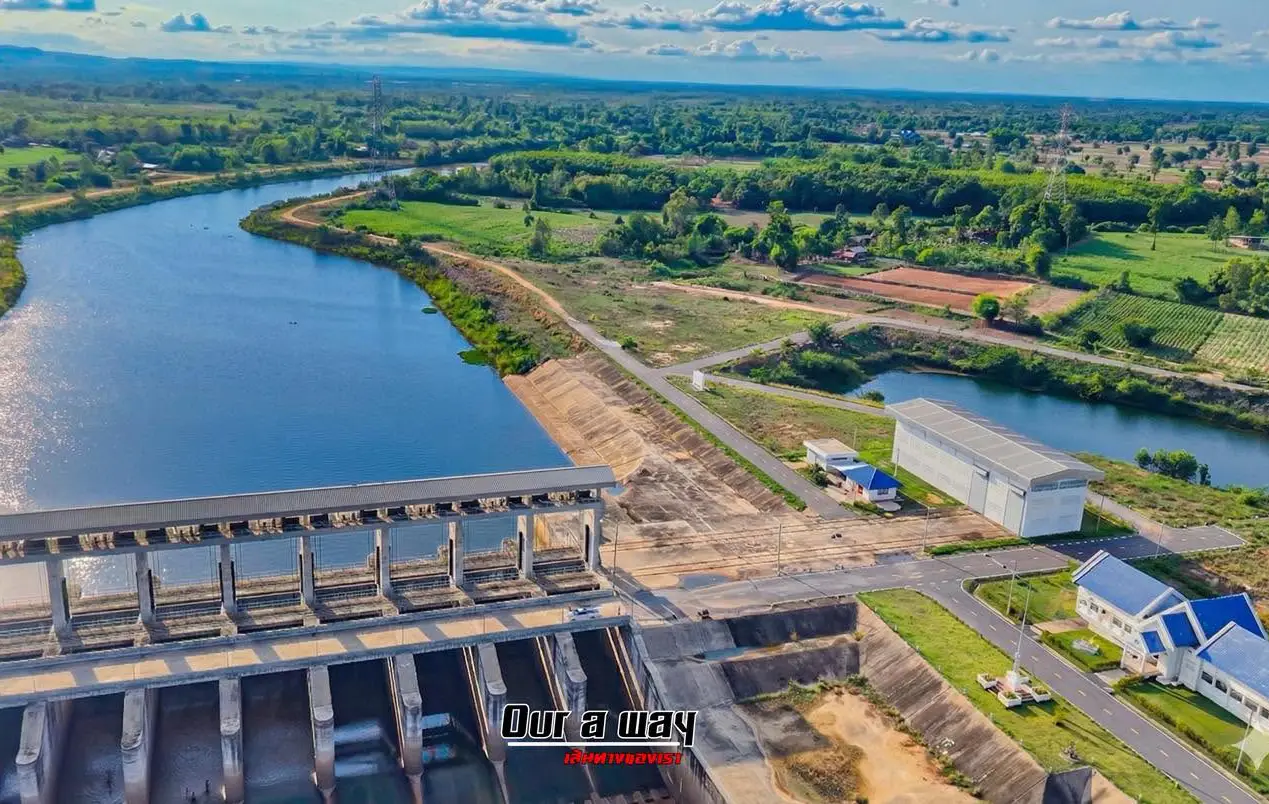
The lower section contains the Huai Bang Sai Watergate at Ban Don Muai in Bang Sai Noi Subdistrict. The structure, which has a storage capacity of approximately 2.87 million cubic metres, is managed by the Mukdahan Irrigation Project. It helps control water before Huai Bang Sai reaches the Mekong, supporting agriculture, retaining water and responding to changes in the Mekong’s level.
Watergate operation affects both the local level and aquatic movement. During heavy rain or changing river conditions, irrigation officers may adjust the gates as part of the water-management plan. Visitors must remain away from gates, discharge channels and rapidly accelerating water. Climbing barriers, walking on restricted structures and jumping into the water from irrigation infrastructure are extremely dangerous.
Huai Bang Sai is also important to riverside farming in Bang Sai Yai. When the level falls, some land close to the channel is used for seasonal crops. Moisture and deposited sediment can support cultivation, but activity must not obstruct the main flow. Low fields can flood quickly after heavy upstream rain, requiring residents to monitor forecasts and water levels carefully.
The agricultural landscape is part of the visitor experience, but it must be observed respectfully. Rice fields, plantations and livestock areas are workplaces and private property. Visitors should request permission before entering, photographing workers at close range or approaching crops. Vehicles must not block field access, and no produce may be collected without the owner’s consent.
The watercourse can be understood through several landscape and use zones. The first is the Phu Phan headwater and upper-basin development area around Kok Tum. The second is Ban Phon Hai and Tha Kaeng Duea in Nong Khaen. The third is the Ban Kan Lueang Dong agricultural corridor. The fourth is the Kham Pa Lai community section. The final zones include Bang Sai Yai, Bang Sai Noi, the watergate and the connection with the Mekong River.
These zones describe geography and use; they are not official tourism districts. Each section has different ownership, management and rules. Public roads and bridges may be used for viewing without obstructing traffic, while farms, community forests, landing places and irrigation structures may require permission from landowners, local authorities or the responsible agency.
No single organization manages the entire stream. Nong Khaen Subdistrict Municipality coordinates public areas and community activities around Ban Phon Hai and Kan Lueang Dong. Kham Pa Lai Subdistrict Municipality manages local roads, bridges and public areas in its jurisdiction. Bang Sai Yai Municipality performs similar functions in the lower basin, while the Mukdahan Irrigation Project manages irrigation structures and the watergate. Effective conservation therefore depends on cooperation between agencies, municipalities and residents.
Tha Kaeng Duea demonstrates how a community can use a natural resource for small-scale recreation without constructing a major tourism complex. When water conditions are suitable, local food, seating and related services can generate income. Proper management must include waste control, parking, sanitation, visitor capacity and water safety. Without these measures, short-term economic activity could damage the bank and water quality.
Before visiting Tha Kaeng Duea, travelers should contact Nong Khaen Subdistrict Municipality or a Ban Phon Hai coordinator. Confirm whether the area is operating, whether the water level is suitable, whether food and seating services are available, and what vehicle can use the final road. A promotional photograph from a previous hot season does not confirm that the area is open on the intended date, particularly during the middle of the rainy season.
Suitable activities include landscape viewing, photography, resting in an authorized area, learning about community life, birdwatching and studying riverside plants and water management. Photographers can document seasonal contrasts: high rainy-season water, exposed dry-season rapids, green rice fields and the agricultural landscape following harvest.
Swimming is appropriate only on a day when the community has opened a defined area, the water is shallow and slow, and supervision is available. Do not enter simply because other people are present. Children must wear properly fitted life jackets and remain within immediate adult reach. Jumping from bridges, rocks or structures is prohibited because depth and submerged hazards can change continuously.
Alcohol should not be consumed before or during water activities. It reduces balance, judgment and emergency response. Eating areas should remain separate from the water, and glass containers must not be taken onto the bank. Broken glass can remain hidden in sand or move downstream, creating a long-term hazard.
Inflatable rings, small rafts and similar equipment should be used only with local permission and within a designated area. Wind and current can move them downstream rapidly. Ropes must not be stretched across the stream or tied to riverside trees because they may obstruct local boats and fishing equipment or injure someone carried downstream.
Canoeing or using a small boat requires more than a visual assessment. The route, depth, current, submerged wood, nets, weirs and other obstacles must be checked with the community. Every occupant must wear a life jacket, a phone should be secured in a waterproof bag, and people on land must know the launch and landing points.
Birdwatching is best during the early morning or late afternoon. Vegetation and farmland beside the water attract several bird groups. Observers should use binoculars, avoid nests and limit recorded bird calls. Particular care is required on banks after rain because apparently solid overhanging soil may have been undercut and can collapse under a person’s weight.
Photography positions must not block bridges, roads or agricultural entrances. Tripods should stand on firm ground well away from the bank edge. Drone operation must comply with aviation rules, community privacy and local permission. Flying at low altitude over houses, swimmers or livestock is inappropriate, while commercial filming requires advance authorization.
Families should choose level, supervised areas away from the main current. Children must not run on wet ground, climb bridge railings or walk down the bank alone. Adults should explain that stones must not be thrown toward swimmers, wildlife should not be handled and every child must leave the water immediately when a warning is issued.
Older travelers can view the scenery from community roads, bridges and accessible rest areas, but should avoid mud, steep banks and sections without handrails. A folding chair, drinking water, a hat and regular medication are useful. Morning and late afternoon are preferable during hot weather, as some riverside areas have limited shade.
Solo travelers should share their destination and return time, avoid swimming in isolated sections and never follow the bank into an area hidden from the road. Mobile reception may be available in villages but less consistent near hills and remote farmland. Traveling with a local person reduces the risk of entering private land or misjudging water conditions.
Recommended equipment includes drinking water, snacks, sun protection, insect repellent, secure footwear, spare clothing, a waterproof phone bag, basic first aid and a rubbish bag. Water activities require a life jacket appropriate to the wearer’s weight. Small inflatable toys are not substitutes for certified safety equipment.
Food should be carried in reusable or easily removable containers. Foam and unnecessary single-use plastic should be avoided. Every item must leave with the visitor, including fruit peel, tissues and cigarette ends. Plastic discarded at Ban Phon Hai can travel downstream toward the watergate and eventually enter the Mekong.
Rubbish must not be burned and fires must not be made without authorization. Dry-season grass and leaf litter can ignite easily, while digging fire pits during the rainy season damages a soft bank. When cooking is permitted, only the designated area should be used. Charcoal, oil and food residue must never enter the water.
Quiet behavior shows respect for communities along the stream. Huai Bang Sai passes close to homes, schools, temples and workplaces. Loudspeakers should not disturb residents, and evening activities must end before darkness. Tourism that generates income while reducing local quality of life cannot remain sustainable.
There is no standard admission fee because Huai Bang Sai is a natural public watercourse. Seasonal recreation points may charge for seating, rafts, food, parking or community services. Prices should be confirmed before use, and fair payment supports cleaning, traffic management and local livelihoods.
Facilities vary substantially. Tha Kaeng Duea may have food, seating and parking during the operating season, while bridges and other viewpoints may have no toilets, shops or resident staff. Travelers should use facilities, buy supplies and refuel in the community before entering a remote section.
Getting There to Tha Kaeng Duea from Mukdahan city generally involves following Highway 212 north, turning at Kham Pa Lai onto the local Kham Pa Lai–Kan Lueang Dong road, and continuing through Nong Khaen Subdistrict to Ban Phon Hai. Navigation should be combined with community signs, and Nong Khaen Subdistrict Municipality should be contacted for the current final approach.
A private car or motorcycle is the most convenient option. The community roads are shared with motorcycles, tractors, agricultural trucks, children and domestic animals. Drivers must reduce speed inside villages. During the rainy season, bridge approaches and roads beside the stream should be checked for erosion, subsidence and flooding.
Vehicles must not be left on bridges, curves, narrow roads or agricultural access points. Even a brief photography stop can obstruct residents and emergency vehicles. Use designated parking, lock the vehicle and remove valuables. A car parked close to the water should be moved immediately when heavy rain begins.
Public transport travelers can use services operating on the Mukdahan–That Phanom or Dong Luang corridors and arrange a local transfer to Ban Phon Hai. The fare, waiting period and return pickup must be agreed in advance because no scheduled vehicle travels directly to Tha Kaeng Duea, particularly when seasonal services are closed.
A half-day itinerary can leave Mukdahan city in the morning, visit Ban Phon Hai Community Forest or Wat Phu Tham Phra and then continue to Tha Kaeng Duea when it is operating. Two or three hours can be spent in the area before lunch in central Dong Luang. Swimming should be removed from the plan immediately when weather or water conditions are unsuitable.
A full-day itinerary may combine Tha Kaeng Duea with Huai Rai Reservoir, Wat Pho Si Kaeo and the natural viewpoint known as Pha I Koeng or Phu Kai Khia. These places present community forest, water management, agriculture and religious heritage. Each destination must be checked separately because some natural areas can close during heavy rain or the forest-fire season.
Travelers interested in the complete watershed can study it in several stages, beginning with the Kok Tum headwaters and upper-basin reservoirs, continuing through Dong Luang, Nong Khaen, Kan Lueang Dong and Kham Pa Lai, and ending at Bang Sai Yai, Bang Sai Noi, the watergate and the Mekong. The route requires more than one day. Driving directly along the bank is inappropriate because roads are discontinuous and much of the land is private.
Most convenient restaurants are located in central Dong Luang and communities beside the main roads. Options include coffee, made-to-order dishes, som tam and northeastern Thai food. Vendors at Tha Kaeng Duea operate seasonally and according to visitor demand. Meals and supplies should be obtained before entering the area rather than assuming that food will be available.
The closest accommodation is generally located around Dong Luang. Mukdahan city provides a wider selection of hotels and services but requires additional travel to Ban Phon Hai. Travelers should telephone the property to confirm availability, location and reception time because small local accommodation may not operate a complete online reservation system.
Using local restaurants, guides and agricultural products allows tourism revenue to remain in the community. Businesses should in turn reduce foam and plastic, provide adequate waste collection and avoid placing structures in the natural drainage path. Economic use must remain compatible with the continued health of the stream.
Waste management is essential to the future of every recreation point. Bottles, bags, straws and food packaging can enter the current easily. Rubbish discarded at Ban Phon Hai may travel through downstream communities and reach the Mekong. Visitors should remove everything they bring, while operators must inspect the site and arrange regular waste collection.
Restaurant and toilet wastewater must not be discharged directly into the stream. Fat, food residue and detergents reduce water quality and affect aquatic life. Seasonal service areas require washing and wastewater facilities away from the bank. Tourism development without sanitation would destroy the resource that attracts visitors.
Bank erosion is another concern. Clearing vegetation for seating, parking close to the water and creating uncontrolled ramps weaken the soil. Rain then carries sediment into the stream and causes collapse. Communities can reduce damage by using existing stable areas, limiting vehicles and retaining natural vegetation.
Changing climate patterns make rainfall less predictable. A long dry period may be followed by intense rain over a short time. Tourism and water management must therefore use current forecasts and upstream rainfall information rather than relying only on the traditional seasonal calendar. Canceling an activity because water is unsafe is a necessary safety decision.
Huai Bang Sai is also valuable for schools, universities and youth groups. Suitable subjects include the water cycle, land use, headwater forest, water quality, riverside plants, community fisheries and multi-agency management. Sampling and research require permission, and animals or plants must not be removed without a legitimate study plan.
Interviews with community elders can preserve knowledge about historic water levels, fish migration, drought, floods and traditional use. Researchers and visitors must request permission before recording or publishing. Community knowledge should not be commercialized without proper credit and benefit to the people who provided it.
Foreign visitors should understand that Huai Bang Sai is not a single tourism site but a living watershed and cultural landscape. Scenic driving must respect privacy, and riverside activity must not obstruct farming or fishing. Recreation must adapt to nature rather than attempting to make the stream function as a permanently controlled commercial water park.
Before leaving, check all belongings and remove every piece of rubbish. Fish, plants, rocks and other resources must not be taken without permission. Collecting safely accessible litter left by others is helpful, but no one should enter a strong current or approach an operating watergate to retrieve waste.
Huai Bang Sai is therefore much more than a stream passing through Nong Khaen, Kan Lueang Dong and Kham Pa Lai. It connects the Phu Phan headwaters, reservoirs, ethnic communities, agriculture, fisheries, Tha Kaeng Duea, irrigation structures and the Mekong. Visitors who understand these connections will appreciate the landscape and riverside life more deeply than those arriving only to swim or take photographs.
The most responsible journey begins by checking local information, visiting during daylight, using only community-designated areas and changing plans whenever water or weather becomes unsafe. Continued cooperation in protecting water quality, riverside vegetation and community rules will allow Huai Bang Sai to remain an important water resource, outdoor classroom and attractive natural landscape of Mukdahan Province.
| Name | Huai Bang Sai Stream, Mukdahan |
| Thai Name | ลำห้วยบางทราย จังหวัดมุกดาหาร |
| Site Type | A major natural watercourse, headwater system, agricultural resource, community fishery and seasonal recreation landscape |
| Areas Along The Watercourse | The Phu Phan headwaters and Kok Tum Subdistrict, followed by Nong Khaen, Ban Kan Lueang Dong, Ban Phon Hai, Ban Bang Sai Phatthana, Kham Pa Lai, Bang Sai Yai and Bang Sai Noi before connecting with the Mekong River |
| Length | Irrigation documents describe the watercourse as approximately 90 kilometres long |
| Visitor Reference Point | Tha Kaeng Duea, Huai Bang Sai, Ban Phon Hai, Moo 3, Nong Khaen Subdistrict, Dong Luang District, Mukdahan Province |
| Highlights | Phu Phan headwaters, seasonal rapids, agricultural and fishing life, Tai So community heritage at Ban Phon Hai and the lower-basin water-management system before the Mekong |
| Caretakers | Public areas are jointly managed by the communities and municipalities in each jurisdiction, including Nong Khaen, Kham Pa Lai and Bang Sai Yai subdistrict municipalities. Irrigation structures and the watergate are managed by the Mukdahan Irrigation Project |
| Main Contact Numbers | Nong Khaen Subdistrict Municipality: +66 42 644 069 Ban Phon Hai Community Coordinator: +66 93 507 5759 Kham Pa Lai Subdistrict Municipality: +66 42 643 058 Bang Sai Yai Subdistrict Municipality: +66 42 674 283 Mukdahan Irrigation Project: +66 42 611 569 |
| Landscape And Use Zones | 1. Phu Phan headwaters and Upper Huai Bang Sai Basin Development Project around Kok Tum 2. Tha Kaeng Duea and Ban Phon Hai community area 3. Ban Kan Lueang Dong and the central agricultural corridor 4. Kham Pa Lai community section 5. Bang Sai Yai and Bang Sai Noi agricultural floodplain 6. Huai Bang Sai Watergate and the connection with the Mekong River |
| Activities | Scenic viewing, photography, community learning, birdwatching and study of headwater forest, irrigation, farming and traditional fisheries. Swimming is permitted only in a locally approved area when conditions are safe |
| Open Days | Public areas are generally accessible every day. Tha Kaeng Duea and community services operate seasonally according to water levels and announcements from Nong Khaen Subdistrict Municipality |
| Opening Hours | No official gate hours; recommended visiting time is 06.00–18.00, with departure before darkness |
| Fees | No standard admission fee. Seasonal service charges may apply to seating, rafts, food, parking or other community facilities |
| Facilities | Tha Kaeng Duea may provide seasonal food, seating and parking. Facilities are limited elsewhere, and travelers should carry drinking water, sun protection, rubbish bags and personal safety equipment |
| Best Visiting Period | The cool season is suitable for scenic travel. Tha Kaeng Duea may operate during the hot season when the water is lower. Avoid water activities during the rainy season |
| Travel Information | From Mukdahan city, follow Highway 212 north, turn onto the Kham Pa Lai–Kan Lueang Dong local road and continue through Nong Khaen Subdistrict to Ban Phon Hai. Confirm the final route with Nong Khaen Subdistrict Municipality |
| Recommended Transport | Private car or motorcycle. Check bridge approaches, riverside roads and the final route to Tha Kaeng Duea during the rainy season |
| Safety | Be alert for flash floods, strong currents, collapsing banks and slippery surfaces. Do not jump from bridges or irrigation structures, and never enter discolored or debris-filled water. Children require life jackets |
| Nearby Tourist Attractions | Approximate road distances from Tha Kaeng Duea, Ban Phon Hai 1. Ban Phon Hai Community Forest, approximately 2 km 2. Wat Phu Tham Phra, Ban Phon Hai, approximately 5 km 3. Huai Rai Reservoir, approximately 9 km 4. Wat Pho Si Kaeo, Ban Kan Lueang Dong, approximately 12 km 5. Pha I Koeng or Phu Kai Khia, approximately 24 km |
| Nearby Restaurants | Approximate road distances from Tha Kaeng Duea, Ban Phon Hai 1. Chompoonick Garden, Dong Luang, approximately 18 km, Tel. +66 82 518 3318 2. Som Tam Pa Sadet, Dong Luang, approximately 19 km, Tel. +66 82 920 4629 3. Dong Luang Fresh Coffee, approximately 19 km, Tel. +66 81 592 3610 4. Café Amazon, PTT Dong Luang, approximately 20 km, Tel. +66 96 635 8510 5. Kafae Phloeng, Dong Luang, approximately 20 km, Tel. +66 82 002 7363 |
| Nearby Accommodations | Approximate road distances from Tha Kaeng Duea, Ban Phon Hai 1. Ban Phak Kanok-on, Dong Luang, approximately 17 km, Tel. +66 87 257 6088 2. Super Tree Hotel Dong Luang, approximately 18 km, Tel. +66 64 471 4956, +66 89 445 2642 3. HOP INN Mukdahan, approximately 52 km, Tel. +66 92 258 7318 4. Riverfront Hotel Mukdahan, approximately 54 km, Tel. +66 42 612 948, +66 42 612 949, +66 81 703 1705 5. Hotel de Ladda Mukdahan, approximately 54 km, Tel. +66 42 611 499, +66 42 611 497 |
Frequently Asked Questions (FAQ)
Q: Where is Huai Bang Sai located?
A: Huai Bang Sai is a major watercourse in Mukdahan Province. It originates in the Phu Phan uplands of Dong Luang District and passes Nong Khaen, Ban Kan Lueang Dong, Ban Phon Hai, Ban Bang Sai Phatthana, Kham Pa Lai and lower-basin communities before connecting with the Mekong River.
Q: Which location is most suitable for a visitor wishing to see Huai Bang Sai?
A: Tha Kaeng Duea at Ban Phon Hai, Moo 3, Nong Khaen Subdistrict, is the clearest seasonal community recreation point. Contact Nong Khaen Subdistrict Municipality before traveling.
Q: Is swimming available at Tha Kaeng Duea throughout the year?
A: No. Swimming depends on water level, weather and community operation. It must be avoided during the rainy season and whenever the water is discolored, rising or moving rapidly.
Q: Is there an admission fee?
A: There is no standard admission fee because Huai Bang Sai is a natural watercourse. Seasonal charges may apply to seating, rafts, food, parking or other community services.
Q: When is the best time to visit?
A: November to February is suitable for scenery and community travel. Tha Kaeng Duea may operate in the hot season when the level becomes lower and the community confirms that conditions are safe.
Q: Can children enter the water?
A: Children may enter only a locally approved shallow area under immediate adult supervision and while wearing properly fitted life jackets. They must not enter during strong flow, rising water or an absence of supervision.
Q: Who manages Huai Bang Sai?
A: Each section is coordinated by the relevant municipality and community, including Nong Khaen, Kham Pa Lai and Bang Sai Yai. Irrigation structures and the watergate are managed by the Mukdahan Irrigation Project.
Q: Who should travelers contact before visiting Tha Kaeng Duea?
A: Contact Nong Khaen Subdistrict Municipality at +66 42 644 069 or the Ban Phon Hai community coordinator at +66 93 507 5759 to confirm water conditions, access and available services.
 Category: ●Nature and Wildlife
 Group: ●River, Canal
Last Update : 3 MonthAgo
 Last Update : 3 MonthAgo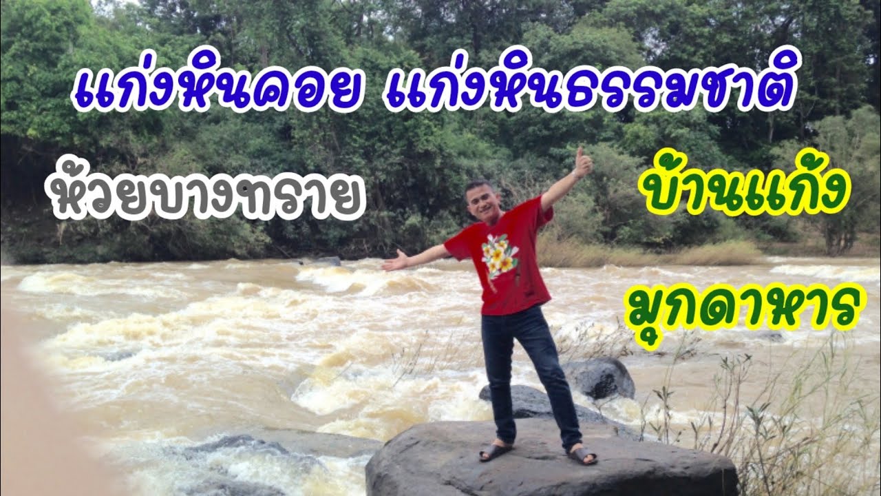
 Click to Access the Navigation Map GPS
Huai Bang Sai Map
Recommend

 Art, Culture and Heritage
 Historical Sites and Monuments(2)
 Landmarks and Memorials(3)
 Art, Craft Centres, Tradition(2)
 Museums(1)
 Places of Worship
 Temple(17)
 Other Sacred Sites(3)
 Suburban Living
 Village, Community(4)
 Local Market(2)
 National Parks and Marine Reserves(4)
 Mountain (Doi)(5)
 Dam, Reservoir, Lake(3)
 Waterfalls(5)
 Caves(2)
River, Canal(2)
Caves(2)
River, Canal(2)
 Bays and Beaches(1)
 Other natural attractions(1)
 Entertainment and Agricultural
 Farms, Parks and Ecotourism(1)
 Travel Articles, Recipes
 Travel Review, Food Review(1)


