
lovethailand home >Northeastern Travel Attractions >Mukdahan Travel Attractions >Wan Yai >Pong Kham > Kaeng Kabao
TL;DR: Kaeng Kabao is located at Ban Na Kae Noi, Pong Kham Subdistrict, Wan Yai District, Mukdahan Province, Thailand, open Daily, hours Open throughout the day; visiting between 06.00 and 18.00 is recommended.

Kaeng Kabao
Open Days: Daily
Opening Hours: Open throughout the day; visiting between 06.00 and 18.00 is recommended
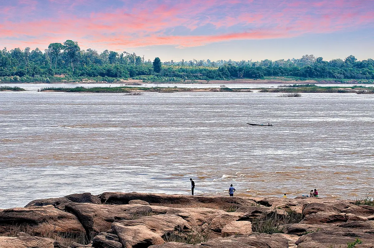
Kaeng Kabao in Mukdahan Province is a distinctive Mekong River attraction known for its long formation of natural rapids, rock outcrops, broad stone terraces, and seasonal sandbanks. The riverside has been developed into a public park with walking areas, viewpoints, cultural plazas, restaurants, and spaces where families can relax. Kaeng Kabao is at its most visually dramatic during the dry season, when the falling river level exposes broad rock surfaces, small islands, channels, and sandy areas that remain hidden during the months of high water.
The destination also contains several modern cultural landmarks. The most prominent is Phaya Si Phuchong Mukda Nakarat, an enormous white Naga sculpture facing the Mekong River. Nearby are a plaza representing the 12 animals of the Thai zodiac, a cultural area associated with Mukdahan’s eight ethnic communities, a landscaped riverside promenade, and a cluster of restaurants famous for Kaeng Kabao-style roasted suckling pig. These elements allow visitors to combine nature, local food, cultural interpretation, spiritual belief, and cross-border scenery in a single visit.
Kaeng Kabao is located at Ban Na Kae Noi, Moo 10, Pong Kham Subdistrict, Wan Yai District, Mukdahan Province. It lies approximately 35 kilometers north of Mukdahan city and within convenient driving distance of That Phanom District in Nakhon Phanom Province. On the opposite bank of the Mekong is Xayburi in the Lao People’s Democratic Republic. The river therefore appears not only as a natural feature but also as an international boundary and a cultural corridor connecting communities with closely related traditions.
The original identity of Kaeng Kabao comes from the rock formation extending along the river. Water moving through the area over a long period has eroded the stone into varied shapes. Some sections have become flat terraces, while others contain holes, channels, depressions, narrow cuts, and cavities beneath the surface. When the river falls, these formations create a striking natural landscape that visitors can examine from the shore and from safe sections of the exposed rock.
The rapids do not look the same throughout the year. The Mekong changes according to rainfall, upstream flow, seasonal conditions, and the amount of water moving through the river system. During the high-water season, many rocks are submerged and the river appears broad and powerful. During the dry months, the water gradually retreats, revealing stone surfaces and sandbanks within a relatively short period.
January to May is generally the most suitable period for travelers who specifically wish to see the exposed rapids, river islands, and natural sand. Lower water allows more of the geological detail to be observed. Visitors can walk across designated safe areas, rest on the riverbank, photograph the rock patterns, and watch water moving through the remaining channels. However, a low river does not mean that every section is safe. Deep holes and powerful currents can remain between the rocks.
The rainy season presents a different version of Kaeng Kabao. The Mekong becomes wider, darker, and more forceful, while most of the exposed terraces and sandbanks disappear beneath the water. Visits during this period should focus on the public park, the promenade, the Naga plaza, and established viewpoints. Travelers should observe local warnings and avoid approaching flooded rocks or entering the river when currents are strong.
Kaeng Kabao is therefore attractive in more than one season. The dry months reveal the structure of the rapids, while the rainy months demonstrate the scale and energy of the Mekong. The period following the rains offers greener surroundings, and the cool season provides comfortable conditions for walking and outdoor meals. Travelers should select their dates according to whether they prefer exposed rocks, mild weather, or the appearance of a full river.
The area is not only a tourist viewpoint. It is connected to the fishing life of riverside communities. Rock channels, pools, and variations in current provide habitats for aquatic species. Local fishers use detailed knowledge of seasonal water levels and river behavior when working in the area. Visitors should therefore understand that the landscape is also a source of food, employment, and community identity.
Fishing equipment must not be moved, handled, or obstructed. Food waste and plastic should never be thrown into the river because debris can become trapped in rock channels or enter aquatic habitats. Responsible behavior protects both the appearance of the attraction and the natural resources on which local residents depend.
The riverbank has been landscaped as a public park containing paved areas, greenery, resting spaces, viewpoints, and photography locations. The park allows elderly visitors, families with small children, and travelers who do not wish to walk over natural rocks to enjoy the Mekong safely from established areas. It also functions as an everyday recreation space for residents of Wan Yai District rather than serving tourists alone.
The most recognizable landmark is Phaya Si Phuchong Mukda Nakarat, a large white Naga sculpture oriented toward the Mekong. The Mukdahan Provincial Office of Public Works and Town and Country Planning developed the landmark as part of the riverside landscape in 2017. The marble-decorated sculpture is approximately 11.11 meters high and 51.4 meters long, making it a dominant feature of the park.
The name of the Naga is associated with auspiciousness, prosperity, and Mukdahan Province. Naga beliefs are deeply connected to communities along the Mekong, where the serpent is regarded as a guardian of water, sacred places, and human communities. Many visitors come to pray and pass beneath the body of the sculpture in accordance with beliefs concerning happiness, health, stability, wealth, and success.
Visitors should approach the Naga with respect. Climbing on the sculpture, placing personal objects on its body, or obstructing people who are praying is inappropriate. When a ceremony is taking place, photography should not interfere with the order of the event. Respectful conduct preserves the spiritual meaning of the landmark and prevents it from becoming merely a decorative background.
The Naga plaza has been designed in visual relationship with the Mekong. Its white surface contrasts strongly with the river, sky, and surrounding vegetation. Morning light from the Lao side reveals details of the scales and head, while afternoon light produces a different appearance across the long body. Both wide-angle photographs and close studies of the ornamentation can be made from the established paths.
The 12-Zodiac Plaza uses the animals of the traditional zodiac as decorative and educational features. Families often look for the animal corresponding to their birth year and take photographs beside it. The plaza introduces children to the order and names of the zodiac while connecting a traditional belief system with a contemporary public space.
The Eight Ethnic Communities Cultural Plaza represents another important aspect of Mukdahan. The province is home to communities with varied languages, dress, food, customs, music, and religious traditions. Presenting this cultural diversity at Kaeng Kabao helps visitors understand that the province’s identity extends beyond its natural river scenery.
Travelers interested in local culture can use the plaza as an introduction before visiting communities, museums, temples, and churches elsewhere in Wan Yai District. Observing the symbols and cultural references in the park provides useful context for a longer journey. This approach turns the visit into more than a brief stop for photographs.
The riverside promenade is suitable for slow walking and quiet observation. Visitors can see the width of the Mekong, small fishing boats, vegetation on the opposite bank, and communities in Laos. On clear days, the Lao shoreline is easily visible. Wind moving across the river makes mornings and late afternoons comfortable, although open sections of the park can become hot around midday.
Early morning is an excellent time for travelers seeking a peaceful atmosphere. The sun rises from the direction of Laos, creating reflections on the river and adding definition to exposed rocks during the dry season. Visitors may also observe fishermen beginning their work. Arriving before 08.00 makes parking and movement around the park easier on weekends and public holidays.
Late afternoon and early evening are suitable for walking, photography, and dining. Although the sun sets behind the Thai side rather than directly across the river, the evening sky and reflected light create softer colors over the water. After dark, visitors should remain in illuminated areas and should not descend to natural rock platforms near the river.
Kaeng Kabao is well suited to family travel because the park combines viewpoints, religious landmarks, cultural spaces, restaurants, and open walking areas. Adults must supervise children continuously near steps, railings, exposed rock, and water. A section that looks shallow can contain a deep depression or a narrow current beneath the surface.
Elderly travelers can comfortably visit the public park, Naga plaza, and principal promenade. Shoes with good grip are recommended, and regular rests should be taken in hot weather. Wheelchair users may require assistance on sloping surfaces or uneven transitions. The natural rock terraces are not suitable for wheelchairs or people with limited balance.
The riverside park can be used for picnics and shared meals, but food should be consumed at suitable resting points without blocking paths. All waste must be removed after use. Lightweight plastic can easily be blown into the Mekong, while discarded food attracts animals and creates unpleasant conditions for later visitors.
Swimming or entering the water requires careful judgment. A section that appears calm may contain underwater channels, rock holes, sudden changes in depth, or a current moving below the visible surface. Wet stone can become extremely slippery, particularly where the water is slow enough for algae to grow. Weak swimmers should remain out of the river, and children should use appropriate flotation equipment under constant adult supervision.
Visitors must not enter the water during high-flow conditions. The Mekong can move powerfully through channels concealed beneath the surface. Decisions should be based on actual river conditions, warning signs, weather, and local advice rather than on the behavior of other visitors. Safety is more important than obtaining a photograph or participating in a recreational activity.
Anyone walking over exposed rock should watch every step. Pools may be deeper than they appear, and gaps can cause ankle injuries. Photographers should never walk backward without checking the ground. Climbing steep or unstable formations for a better camera angle should be avoided. Closed shoes with effective grip are safer than sandals.
Midday heat can be intense because some sections of the riverbank and rock terrace have limited shade. Stone surfaces absorb and reflect heat. Hats, umbrellas, sunscreen, and drinking water are essential, particularly for children and elderly travelers. Morning visits or arrival after approximately 15.30 provide more comfortable conditions.
During thunderstorms, visitors should leave exposed plazas and the river edge. Standing beneath an isolated tree or beside metal railings is unsafe. Rain makes rock surfaces, stairs, and paved walkways slippery. A sustained storm is a reason to change the itinerary and visit an indoor attraction instead.
The ecology of the rapids is more fragile than it may appear. Small plants growing in cracks must survive alternating floods, drought, and extreme heat. Leaving established paths can crush this vegetation. Rearranging stones for photographs can disturb small aquatic or terrestrial organisms. The area should be left in its natural condition.
Writing names, painting, or carving on rocks and public structures is prohibited and causes damage that is difficult to repair. Stones, sand, plants, and aquatic animals must not be taken as souvenirs. Appropriate souvenirs should be purchased from local shops or community producers, allowing tourism income to support residents without damaging the natural environment.
One of the most popular parts of a Kaeng Kabao visit is eating Kaeng Kabao roasted suckling pig. Several restaurants operate close to the public park and the Mekong, allowing visitors to dine with a river view. Roasted pig has become the signature food of the destination and attracts families and groups who travel specifically to share a meal.
The local style is valued for thin, crisp skin and tender meat with the aroma of charcoal roasting. Each restaurant prepares its own dipping sauce, producing different combinations of sweet, salty, sour, and spicy flavors. A whole pig is often roasted to order, so advance reservation is recommended on weekends, holidays, and festival periods.
A whole roasted pig is designed for a group. Solo travelers and couples should ask whether smaller portions or alternative dishes are available. Most restaurants also serve northeastern Thai food, som tam, larb, soups, grilled dishes, Mekong fish, and standard Thai meals. Planning the number of diners reduces food waste and helps the restaurant prepare an appropriate size.
Mekong fish dishes connect local dining with the river environment. Availability varies according to season and the catch. Travelers should ask about the species, price, and cooking method before ordering. Soups, grilled fish, fried dishes, and minced fish salads express the culinary identity of riverside communities.
Using local restaurants, cafés, accommodation, and shops distributes tourism income within Pong Kham Subdistrict. Many businesses depend on dry-season tourism, weekends, and public holidays. Calling in advance, stating the size of the group, and paying fair prices help local businesses manage ingredients and maintain service quality.
A half-day morning itinerary can begin between 07.00 and 08.00. Walk through the riverside park, observe the Mekong, and explore safe sections of the exposed rock during low water. Return to the park to pay respect at the Naga, visit the zodiac and cultural plazas, and finish with roasted pig or another local lunch.
An afternoon visit can begin after 15.00 to avoid the strongest heat. Start at the Naga plaza and promenade, then view the rapids from accessible areas before dinner beside the Mekong. This program suits families who do not wish to spend a complete day. Restaurant closing times should be confirmed because several establishments finish service relatively early.
A full-day route can combine Kaeng Kabao with the Shrine of Our Lady of the Martyrs of Thailand at Song Khon, Wat Phra Si Maha Pho, Wat Mano Phirom, Mano Phirom Beach, the Nouhak Phoumsavanh Museum, or Wat Phra That Phanom. Such an itinerary includes Mekong nature, Catholic heritage, Buddhist art, local history, cross-border culture, and regional food.
The Shrine of Our Lady of the Martyrs of Thailand at Song Khon is approximately 3 kilometers from Kaeng Kabao. This important Catholic sanctuary stands near the Mekong and is associated with the Martyrs of Thailand. Visitors should dress modestly, remain quiet, and check service times before entering the principal building.
Wat Phra Si Maha Pho is approximately 8 kilometers away. It is an old temple of Wan Yai District containing an Isan ordination hall and art reflecting Thai, Lao-Isan, Vietnamese, and Western influences. Visiting the temple and Kaeng Kabao on the same day reveals the cultural diversity of Mekong communities.
Wat Mano Phirom and Mano Phirom Beach lie farther south along the riverside route. The temple is important to the local Buddhist community, while the seasonal beach appears when water conditions allow. These sites can be used as a stop before continuing toward Mukdahan city.
Wat Phra That Phanom in Nakhon Phanom Province is approximately 24 kilometers from Kaeng Kabao. Travelers staying in That Phanom can easily visit both destinations. Beginning with the temple in the morning and eating lunch at Kaeng Kabao creates a comfortable itinerary for a wide range of ages.
Getting There from Mukdahan city requires following Highway 212 on the Mukdahan–That Phanom route for approximately 20 kilometers. Turn toward Wan Yai District and continue for about 9 kilometers. From the district area, follow signs north for approximately 8 kilometers to Kaeng Kabao.
The total distance from Mukdahan city is approximately 35 kilometers, and driving generally takes 40–50 minutes depending on traffic. Most of the route is paved and suitable for ordinary cars. Navigation systems can search for “Kaeng Kabao” or use the coordinates 16.8020162, 104.733163. Restaurants, signs, and the large white Naga provide clear landmarks near arrival.
Travelers coming from That Phanom can drive south along the Mekong route for approximately 24 kilometers, normally requiring 30–40 minutes. This direction is convenient for visitors staying in Nakhon Phanom Province or continuing toward Wan Yai and Mukdahan.
Public transportation does not regularly reach the riverside park. Travelers without a private vehicle should first reach Mukdahan city, Wan Yai, or That Phanom and arrange a hired car with a clearly agreed return time. Renting a car or traveling with a group also makes nearby attractions easier to reach.
Parking is available near the park and restaurants. Weekends and festivals can be busy. Vehicles should be left only in designated areas without blocking businesses, community access, or emergency routes. Drivers should move slowly because pedestrians, children, and elderly visitors frequently cross between the park and restaurants.
Kaeng Kabao is a public attraction open every day without an admission fee. The outdoor area is accessible throughout the day, but 06.00–18.00 is the most practical and safest period for sightseeing. Restaurants, cafés, and individual services maintain separate business hours. Groups planning to eat roasted pig should reserve in advance.
Facilities include the landscaped park, promenade, resting areas, photography points, parking, restaurants, cafés, and community shops. Seasonal services such as flotation-ring rental or water recreation depend on river level, safety conditions, and the individual operator. Travelers should not assume that water activities are available throughout the year.
The destination can be understood as six principal visitor areas: the natural rapids and seasonal sandbank area, the riverside park and promenade, the Naga plaza, the 12-Zodiac Plaza, the Eight Ethnic Communities Cultural Plaza, and the restaurant and community shop zone. Following these areas in sequence allows an efficient visit without repeatedly crossing the same route.
Travelers with limited time should prioritize the river and rapids viewpoint, the Naga landmark, and local food. Those with more time can explore the cultural plazas and continue to Song Khon or Wat Phra Si Maha Pho. A slower visit provides a better understanding of the river and community than a short photography stop.
Photographers may use a wide-angle lens to include the Naga and Mekong in one frame, while a medium lens is useful for rock details and fishing boats. Tripods should not obstruct walkways. Camera equipment should not be taken onto wet rock, and bags should remain closed against spray, sand, and dust.
Drone use requires careful examination of aviation law, border-area restrictions, and local requirements. Kaeng Kabao stands on an international river boundary. Operating an unmanned aircraft without understanding the restrictions can create legal and security concerns. Ground-level viewpoints should be used when formal permission has not been obtained.
Seeing Laos across the Mekong is part of the attraction, but visitors cannot cross the river freely or use an unauthorized boat route. International travel must pass through an approved immigration checkpoint. Boats and riverside routes not designated for tourism should be avoided.
Pong Kham Dong Mu Subdistrict Administrative Organization manages and promotes Kaeng Kabao in cooperation with Wan Yai District, Mukdahan Province, local businesses, and residents. Its responsibilities relate to landscape maintenance, cleanliness, tourism activities, and local coordination. The organization can be contacted at 042-699-236.
Kaeng Kabao remains an important attraction of Wan Yai District and continues to be included in local tourism development activities. Its future depends not only on constructed landmarks but also on the conservation of the natural rapids, river cleanliness, food quality, visitor safety, and meaningful community participation.
Visitors can contribute by keeping noise at a reasonable level, avoiding alcohol consumption in hazardous river areas, carrying out waste, respecting religious activity, and leaving public structures undamaged. Responsible tourism ensures that economic benefits do not create an environmental or social burden for residents.
Before departure, check the weather, river conditions, and restaurant hours. Bring drinking water, a hat, sunscreen, shoes with good grip, and spare clothing when planning activities close to the water. Families should carry their own child flotation equipment rather than relying on seasonal rental services.
January to May normally provides the best opportunity to see the exposed rocks and sandbanks, although actual river conditions can change from year to year. November to February is suitable for comfortable walking in cooler weather. The final choice should depend on the type of scenery and activity desired.
Kaeng Kabao presents several dimensions of Mukdahan within one destination: the Mekong as a natural resource and international boundary, seasonal rock formations, fishing life, Naga belief, ethnic diversity, and roasted pig as a community culinary identity. Visiting the site is therefore an opportunity to understand the relationship between people, water, and border culture.
A well-planned visit can last from 2–3 hours to a complete day. Travelers may watch the morning light over the Mekong, explore safe rock terraces during low water, pray at the Naga, learn from the cultural plazas, eat local food, and continue to nearby religious or historical sites. The route suits families, photographers, cultural travelers, and anyone seeking a deeper experience of northeastern Thailand’s Mekong region.
The appeal of Kaeng Kabao comes from the way natural simplicity and cultural development exist together. The rock formations and sandbanks are shaped by the river, while the Naga, zodiac plaza, roasted-pig restaurants, and cultural areas represent human creativity and community identity. Protecting both elements will allow Kaeng Kabao to remain a local recreation area, a Mukdahan landmark, and a place of learning for future travelers.
| Name | Kaeng Kabao, Mukdahan Province |
| Location | Ban Na Kae Noi, Pong Kham Subdistrict, Wan Yai District, Mukdahan Province, Thailand |
| Address | Moo 10, Ban Na Kae Noi, Pong Kham, Wan Yai, Mukdahan 49150, Thailand |
| Coordinates | 16.8020162, 104.733163 |
| Attraction Type | Natural attraction, Mekong riverside park, viewpoint, spiritual landmark, cultural space, and local dining area |
| Highlights | Mekong rapids and rock outcrops, dry-season sandbanks, Phaya Si Phuchong Mukda Nakarat, the 12-Zodiac Plaza, the Eight Ethnic Communities Cultural Plaza, and Kaeng Kabao roasted pig |
| Distinctive Features | Natural stone eroded by the Mekong into pools, holes, channels, and varied rock formations, most visible during low water |
| Opposite Bank | Xayburi, Lao People’s Democratic Republic, separated from Thailand by the Mekong River |
| Phaya Si Phuchong Mukda Nakarat | A white marble-decorated Naga approximately 11.11 meters high and 51.4 meters long, developed as a Kaeng Kabao landmark in 2017 |
| Best Period for Exposed Rapids | Approximately January–May, depending on the Mekong water level each year |
| Open Days | Daily |
| Opening Hours | Open throughout the day; visiting between 06.00 and 18.00 is recommended |
| Admission Fee | Free admission |
| Current Status | Open as a public attraction and an important landmark of Wan Yai District |
| Caretaker | Pong Kham Dong Mu Subdistrict Administrative Organization in cooperation with Wan Yai District, Mukdahan Province, local businesses, and the community |
| Main Contact Number | Pong Kham Dong Mu Subdistrict Administrative Organization: 042-699-236 |
| Facilities | Public park, riverside promenade, resting areas, photography points, parking, restaurants, cafés, and community shops |
| Main Areas / Zones | 1. Natural rapids and seasonal sandbank area 2. Riverside park and promenade 3. Phaya Si Phuchong Mukda Nakarat Plaza 4. 12-Zodiac Plaza 5. Eight Ethnic Communities Cultural Plaza 6. Roasted-pig restaurants, cafés, and community shops |
| Activities | Mekong sightseeing, viewing exposed rocks during low water, photography, Naga worship, cultural learning, local dining, and family recreation |
| Safety | Watch for slippery rock, deep pools, hidden channels, and currents. Avoid entering the water during high flow and supervise children continuously |
| Travel Information | From Mukdahan city, use Highway 212 toward That Phanom for about 20 km, turn toward Wan Yai for about 9 km, and follow signs north for another 8 km from the district area |
| Nearby Tourist Attractions | 1. Shrine of Our Lady of the Martyrs of Thailand at Song Khon, about 3 km 2. Wat Phra Si Maha Pho, about 8 km 3. Wat Mano Phirom, about 19 km 4. Mano Phirom Beach, about 19 km 5. Nouhak Phoumsavanh Museum, about 22 km 6. Wat Phra That Phanom, Nakhon Phanom Province, about 24 km |
| Nearby Restaurants | 1. Sirichai Roasted Pig Kaeng Kabao, about 300 m, Tel. 081-260-7358, 042-643-552 2. Sirichai Cafe Kaeng Kabao, about 300 m, Tel. 099-831-9599 3. Jitra Roasted Pig Kaeng Kabao, about 300 m 4. Nong Bow Roasted Pig Kaeng Kabao, about 400 m, Tel. 061-318-9377 5. Thaddao Roasted Pig Kaeng Kabao, about 500 m, Tel. 086-237-3875 |
| Nearby Accommodations | 1. Kaeng Kabao Resort, about 1 km 2. Amy's Mekong Resort, about 8 km, Tel. 080-967-5692 3. Saengthong Rimkhong Hotel, about 18 km 4. Saengthong Heritage, about 18 km 5. That Phanom View Hotel, about 20 km 6. Baan Oon Ai Din Homestay, Mukdahan, about 30 km, Tel. 088-563-9325 |
Frequently Asked Questions (FAQ)
Q: Where is Kaeng Kabao located?
A: Kaeng Kabao is located at Ban Na Kae Noi, Moo 10, Pong Kham Subdistrict, Wan Yai District, Mukdahan Province, approximately 35 kilometers from Mukdahan city.
Q: What are the opening hours, and is there an admission fee?
A: The public outdoor area is open daily throughout the day and admission is free. Visiting between 06.00 and 18.00 is recommended for daylight, sightseeing, and safer access to riverside areas.
Q: What is the best time of year to visit Kaeng Kabao?
A: January to May normally provides the best opportunity to see exposed rock formations, islands, and sandbanks. November to February is suitable for comfortable walking in cooler weather.
Q: What are the main attractions at Kaeng Kabao?
A: Highlights include the Mekong rapids, dry-season sandbanks, Phaya Si Phuchong Mukda Nakarat, the 12-Zodiac Plaza, the Eight Ethnic Communities Cultural Plaza, views of Laos, and local roasted-pig restaurants.
Q: Is swimming allowed at Kaeng Kabao?
A: Entering the water depends on the actual river level, current, weather, and local warnings. Do not swim during high flow or near deep channels. Children must remain under continuous adult supervision.
Q: Should roasted pig be ordered in advance?
A: Advance reservation is recommended for a whole roasted pig, especially on weekends, public holidays, festival periods, and group visits because preparation and roasting require time.
Q: How do travelers reach Kaeng Kabao from Mukdahan city?
A: Follow Highway 212 toward That Phanom for approximately 20 kilometers, turn toward Wan Yai District for about 9 kilometers, and follow the signs to Kaeng Kabao for another 8 kilometers.
Q: Is Kaeng Kabao suitable for children and elderly visitors?
A: Yes. The landscaped park and promenade are suitable for family visits. Elderly visitors should avoid uneven natural rocks, while children must be closely supervised near the river.
 Category: ●Nature and Wildlife
 Group: ●River, Canal
Last Update : 2 MonthAgo
 Last Update : 2 MonthAgo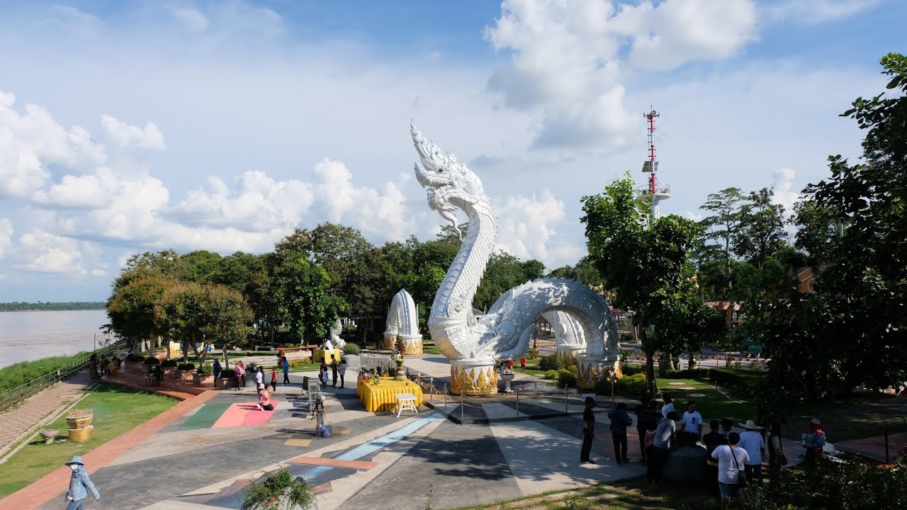
 Click to Access the Navigation Map GPS
Kaeng Kabao Map
Recommend

 Art, Culture and Heritage
 Historical Sites and Monuments(2)
 Landmarks and Memorials(3)
 Art, Craft Centres, Tradition(2)
 Museums(1)
 Places of Worship
 Temple(17)
 Other Sacred Sites(3)
 Suburban Living
 Village, Community(4)
 Local Market(2)
 National Parks and Marine Reserves(4)
 Mountain (Doi)(5)
 Dam, Reservoir, Lake(3)
 Waterfalls(5)
 Caves(2)
River, Canal(2)
Caves(2)
River, Canal(2)
 Bays and Beaches(1)
 Other natural attractions(1)
 Entertainment and Agricultural
 Farms, Parks and Ecotourism(1)


