
lovethailand home >Northeastern Travel Attractions >Mukdahan Travel Attractions >Nikhom Kham Soi >Nikhom Kham Soi > Phu Mu Forest Park
TL;DR: Phu Mu Forest Park, Mukdahan attractions : Nature and Wildlife, National Parks and Marine Reserves.

Phu Mu Forest Park
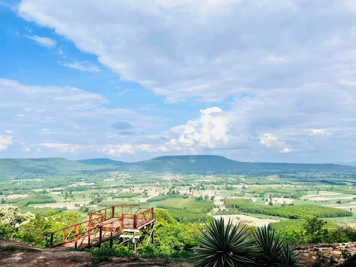
Open Days: Open daily when no ecological-restoration closure, emergency closure, wildfire restriction, or maintenance order is in effect. In 2026, tourism operations resumed on 16 May after the annual restoration period.
Opening Hours: 06.00 – 18.00. Day visitors must descend before the access road closes. Registered campers must enter and complete check-in within the time specified by park staff.
Phu Mu Forest Park in Mukdahan Province is a mountain nature destination known for panoramic viewpoints, seasonal mist, sunrise and sunset scenery, exposed rock areas, dry forest, historical remains, and overnight camping. The site is currently administered as Phu Sa Dok Bua National Park Protection Unit PhB.1 (Phu Mu), near Ban Dan Mon in Nikhom Kham Soi Subdistrict, Nikhom Kham Soi District. The familiar name Phu Mu Forest Park continues to be used by residents and travelers, but camping arrangements, access information, fees, and safety regulations are now coordinated through Phu Sa Dok Bua National Park.
Phu Mu rises approximately 353–356 metres above mean sea level. The small difference between published elevations reflects different survey points and datasets. Its summit contains a relatively broad, level area of approximately 4 square kilometres, or about 2,500 rai. This unusually spacious summit supports forest, rock clearings, viewpoints, a ranger unit, a camping area, and historical remains distributed across several sections. A visit therefore involves more than stopping briefly at a single cliff.
The name Phu Mu, meaning Wild Boar Mountain, is associated with the large number of wild boars that once inhabited the forest. Dry dipterocarp woodland, mixed deciduous forest, bamboo, seasonal water, and open feeding areas provided suitable habitat. Although wild boars are rarely seen beside the visitor zone today, the name preserves a connection between wildlife, the landscape, and communities that have long lived around the mountain.
Failure to see a wild boar does not mean wildlife has disappeared. Most wild animals avoid crowded visitor areas and become active at night, before sunrise, or inside quieter forest. Travelers may find tracks, disturbed soil, droppings, or feeding marks rather than a live animal. Keeping noise low, securing food, remaining on official paths, and avoiding loudspeakers reduces disturbance and allows the mountain to remain suitable wildlife habitat.
Phu Mu forms part of the wider Phu Phan mountain landscape of northeastern Thailand. Connected hills and ridges create broad views in several directions. The eastern side faces reservoirs and neighboring hills and receives the first morning light. The western cliffs look toward layered Phu Phan ridges and are suited to sunset viewing. The southern section faces Phu Tham Phra and Loeng Nok Tha District and includes shaded trees, rock surfaces, and areas used for stargazing by registered campers.
The mountain has long been described as having 3 principal cliff viewpoints. Each presents a different relationship between Phu Mu and the surrounding mountains, roads, reservoirs, settlements, and agricultural land. Visitors should not attempt to reach every viewpoint without considering daylight, weather, trail condition, and physical ability. The ranger unit should be consulted before longer walks or any route that is not clearly marked.
Viewpoint 1 lies east of the ranger unit and is the principal sunrise direction. In clear conditions, visitors can see Phu Tham Men, Phu Mai Sang, Phu Phaeng Ma, and Huai Khi Lek Reservoir. After a humid and cool night, mist may gather over lower land and water, creating layered mountain silhouettes. Mist cannot be guaranteed because it depends on temperature, humidity, wind, cloud, and rainfall.
The eastern area is promoted under the name Lan Tak Bat Khu Tawan, a sunrise-facing ground associated with early-morning cultural or contemplative activities. Campers should arrive at the viewpoint 30–45 minutes before the actual sunrise without using excessive light or disturbing sleeping visitors. Day visitors must wait until the official 06.00 opening and must not use unofficial roads to enter earlier.
Viewpoint 2 faces west over the winding access road, Phu Noi, Phu Tio, Phu Lon, Phu Kalon, Wat Phu Dan Tae, and the layered Phu Phan Range. It is the principal sunset viewpoint. The exact colour and visibility depend on haze, cloud, moisture, dust, and the season. Even when the sun is hidden behind cloud, the western mountains can still provide a changing landscape of shadow and evening light.
The western viewing ground is also known as Lan Suksan Saeng Suri. Visitors should arrive at least 30 minutes before sunset and select a stable position behind the safe boundary. Sitting with legs over a cliff, climbing a boulder, or standing on an overhang is dangerous. Summit winds can intensify quickly and can move tripods, hats, bags, and loose camping equipment.
Viewpoint 3 lies toward the southern summit and looks toward Phu Tham Phra and Loeng Nok Tha District in Yasothon Province. Large trees, shaded ground, and open rock provide places to rest. The area is also promoted as Lan Chumphit Ratri Pradap Dao because the southern sky can be suitable for stargazing on clear nights. Night access is limited to properly registered overnight guests using areas authorized by rangers.
Stargazers should use dim or red lights and avoid directing flashlights into other tents. Walking toward a cliff after dark is unsafe, even under bright moonlight. Cracks, roots, rock edges, and changes in elevation can disappear in shadow. Star observation should take place within an approved open ground rather than through an unplanned night walk.
Current tourism information also uses names such as Pha Rabiang Tawan, Pha Phop Rak, and Pha Song Tawan. These locations add memorable names to the summit experience while connecting visitors with sunrise, sunset, forest, and cliff scenery. Pha Rabiang Tawan is closely associated with the camping zone, while Pha Phop Rak and Pha Song Tawan form part of a nature route whose status should be confirmed before departure.
Pha Rabiang Tawan Campground is popular because registered visitors can remain on the summit and reach morning viewpoints without a long predawn drive. Depending on conditions, the area provides sunrise, sunset, mist, and mountain scenery. Tents must follow the allocation made by staff and may not obstruct emergency lanes, drainage, walking routes, or safe cliff boundaries.
Pha Phop Rak provides another perspective over forest, sandstone, and the surrounding mountain environment. The romantic name should not distract from the physical nature of the site. Photography must remain behind safe limits, and visitors should not pressure companions to stand closer to an edge for a dramatic image.
Pha Song Tawan is associated with the ability to experience changing sunlight from the broad summit landscape. The Pha Phop Rak–Pha Song Tawan route should only be used when officially open and when sufficient daylight remains. Rangers should be asked about distance, duration, difficulty, and whether accompaniment is required.
Phu Mu also contains remains connected with modern regional history. Around 1970, the broad summit was used as a communication, observation, or intelligence-related site by United States forces during the Indochina conflict. Its elevation and extensive view were suitable for communication equipment. Foundations and structural traces remain in parts of the summit, giving the mountain an additional historical dimension.
Old structures must not be climbed or entered without permission. Cracked floors, rusted metal, concealed holes, and unstable sections may present serious hazards. Visitors should not remove fragments, write on walls, or move objects. Preserving the existing remains allows the military and communication history of the site to be studied in the future.
The summit supports dry dipterocarp and mixed deciduous forest. Dry dipterocarp forest grows on shallow, relatively dry soil and includes trees adapted to seasonal drought. Mixed deciduous forest develops where soil and moisture are more favorable. Bamboo, shrubs, herbs, and moisture-dependent vegetation are more common near lower slopes and drainage lines.
Dry forest can appear sparse and brown near the end of the cool season, yet it is a specialized ecosystem. Fallen leaves recycle nutrients and provide shelter for small animals. After the rains begin, the same landscape turns green rapidly. Grass, fungi, herbs, and new leaves emerge, making different seasons feel like visits to different mountains.
Wildfire is a major dry-season risk. Fires, charcoal stoves, discarded cigarettes, and rubbish burning are prohibited outside approved areas. Wind can carry embers quickly across the summit. A small unattended flame can threaten forest, wildlife, campers, roads, and communities below.
Alcohol is prohibited within Thailand’s national parks. Camping at Phu Mu is not intended as a venue for drinking parties, loud music, or uncontrolled fires. Alcohol also increases the risk of cliff falls, route mistakes, conflict, and unsafe cooking.
Rain brings green forest and cooler conditions but can make the access road and walking routes slippery. Strong wind, low cloud, fallen trees, and restricted visibility may occur. Rangers can suspend access or limit vehicle types. Drivers must respect such decisions rather than attempting to force a vehicle up a narrow wet road.
During thunderstorms, exposed viewpoints, ridge lines, isolated trees, and open rock are unsafe because of lightning. Travelers must leave high ground when directed. Metal tripods and long umbrellas should not be held on an exposed summit. Registered campers must be prepared to move to a safer structure if the park issues an instruction.
November to February is the most popular period. Summit temperatures can be considerably cooler than the lowlands, particularly at night and before sunrise. Wind can make conditions feel colder than the forecast. Campers should bring a windproof layer, warm clothing, socks, suitable bedding, and a sleeping bag designed for cool conditions.
Mist is most likely during the transition from the rainy season into the cool season, when the ground and reservoir retain moisture while morning air becomes cold and calm. Some mornings produce broad white layers in the valleys, while others remain completely clear. Mist should be treated as a natural bonus rather than a guaranteed service.
March to May is hot and dry. Exposed rock and open ground store heat, making midday walking uncomfortable and potentially dangerous. The site may also close for ecological restoration during part of this period. In 2026, Phu Mu was closed from 1 March through 15 May. Annual closure dates must be checked before each trip.
A restoration closure is not a permanent shutdown. It allows forest recovery, wildfire prevention, route repair, waste removal, and reduced pressure on wildlife. Visitors must not bypass a closure through village or agricultural roads. Unauthorized entry undermines conservation and creates avoidable rescue risk.
Camping is available according to current park announcements and site capacity. Reservations should include dates, number of guests, number and size of tents, vehicle type, and equipment requirements. Unannounced arrival on a holiday or cool-season weekend may result in no available pitch or parking space.
Camping fees, tent rental, bedding, equipment, and vehicle charges are separate from admission and follow current Department of National Parks rates. Travelers should obtain a current cost summary from the park rather than relying on old reviews or prices from another protected area.
Tents should resist wind and include suitable pegs and guy lines. Summit ground can be hard or rocky, requiring the installation method recommended by staff. Ropes must not damage tree bark, and vegetation must not be cut or bent to create a larger pitch.
Essential camping items include a sleeping bag, ground mat, windproof clothing, headlamp, power bank, personal medicine, water, and waste bags. Gas stoves may only be used in approved cooking areas. Charcoal fires and cooking inside a closed tent are unsafe and prohibited.
Food must be sealed and never left outside a tent. Smells attract insects, rodents, dogs, and wildlife. Animals approaching a campsite must not be fed or photographed at close range. Waste should be delivered to the official collection point and never left beside a full container.
Noise must be controlled, particularly at night. Large speakers, shouting, and late group activities disturb wildlife and other campers. The mountain’s open terrain allows sound to travel over long distances.
Toilets and summit facilities are basic. Water, electricity, shops, and food service may be more limited than at an urban hotel. Visitors should conserve water, keep shared facilities clean, and avoid releasing soap or chemical products onto the soil.
Older tourism material refers to both houses and tents. Camping is the clearly promoted current overnight option. The operating status of any park house must be confirmed before travel. Guests requiring air conditioning, a private bathroom, or full hotel facilities should stay in Nikhom Kham Soi or Mukdahan city.
Food and small retail services at the unit are limited and may operate according to visitor numbers. Travelers should carry adequate water and simple food without creating excessive waste. People with allergies, vegetarian requirements, halal requirements, or medical diets should prepare suitable food in the lowlands.
Rangers provide current information about weather, road access, campground allocation, viewpoints, and the Pha Phop Rak–Pha Song Tawan route. Visitors should register before walking and report the intended route and return time. Unmarked shortcuts should never be used.
Mobile coverage may work on exposed ground but varies by network, weather, and terrain. A telephone should not be the only safety measure. Maps should be downloaded, the park number saved, and the travel plan shared with someone outside the group.
Admission follows the Phu Sa Dok Bua National Park tariff. Thai citizens pay 20 baht for an adult and 10 baht for a child. International visitors pay 100 baht for an adult and 50 baht for a child. Camping, equipment, and vehicle fees are additional.
A half-day visit suits travelers who want the principal views and a short nature walk. Arrive in the morning, register, visit the eastern viewpoint and Pha Rabiang Tawan, and explore nearby historical remains before descending in the afternoon.
A full-day itinerary can include western and southern viewpoints and the Pha Phop Rak–Pha Song Tawan route when open. Adequate rest and return time are essential. Visitors must reach the ranger unit before the 18.00 closure.
A 2-day, 1-night stay provides sunset, stars, and sunrise in one trip. Arrive before the afternoon, finish tent setup before visiting the western viewpoint, remain inside the approved campground at night, and visit the eastern viewpoint early the following morning. The pitch must be cleaned completely before departure.
Families can use Phu Mu as an outdoor classroom for forest, mountain orientation, mist, weather, and camping. Children require continuous supervision. They must not run on rock surfaces, climb barriers, approach cliffs, or enter forest alone.
Older travelers can enjoy areas near the unit and vehicle-accessible viewpoints according to physical ability. Some routes contain slopes, roots, rock, and uneven ground. Visitors with heart, breathing, balance, or mobility conditions should select a short route and remain with a companion.
The natural routes are not fully wheelchair accessible. Wheelchairs may be used around certain roads and service areas, but most forest and cliff paths contain elevation changes. Accessibility needs should be discussed with the park before travel.
Closed-toe footwear with reliable grip, flexible clothing, a hat, water, sunscreen, insect repellent, rain protection, a flashlight, and personal medicine are recommended. Sandals are useful around a tent but not for cliff trails.
Cameras should use secure straps, and equipment bags should remain closed against wind and dust. Tripods must not obstruct a route or extend beyond a safety boundary. Drone operation requires prior permission from the national park authority and aviation authorities.
Portrait photographs should be taken from stable ground behind safety barriers. A telephoto lens and careful camera position can create a dramatic perspective without requiring anyone to stand at an unsafe edge.
Rocks, flowers, seeds, wood, animal remains, and historical materials must remain on the mountain. Photography and written notes are appropriate ways to retain memories without removing protected resources.
Leave-no-trace practice applies to every visitor. Bottles, caps, tissues, cigarette ends, fruit peel, and food scraps must be removed or placed in designated waste facilities. A full bin is not permission to leave rubbish beside it.
The summit road requires careful driving. From Highway 212, the final road is paved but narrow, uphill, and curved. Brakes, tyres, engine cooling, and fuel should be checked before ascent. Low gear should be used on the descent rather than continuous heavy braking.
Passenger cars, pickups, sport utility vehicles, and suitable vans can normally use the road when conditions are good. Large coaches are unsuitable because of limited width, curves, and turning space. Large groups should transfer to smaller vehicles below the mountain.
Motorcyclists need a machine suitable for steep roads, effective brakes, safe tyres, and an approved helmet. Racing through bends or descending with overheated brakes is dangerous. Solo riding in heavy rain, dense fog, or near closing time should be avoided.
Getting There from Mukdahan city: follow Highway 212 toward Loeng Nok Tha and Nikhom Kham Soi. Near kilometre 128–129, turn onto the signed Phu Mu road and continue approximately 12 km uphill. The ranger unit and main campground coordinates are approximately 16.319953, 104.554785.
Navigation applications may display separate markers for Phu Mu Forest Park, the Phu Mu ranger unit, Pha Rabiang Tawan, and individual viewpoints. First-time visitors should navigate to the ranger registration point rather than directly to a cliff marker.
Public transport is limited. Travelers can reach Nikhom Kham Soi by interprovincial or local transport and must then arrange a hired vehicle for the mountain. There is no dependable scheduled service for the final uphill road, and both ascent and descent transport must be confirmed in advance.
Mukdahan Province has no commercial airport. Sakon Nakhon, Nakhon Phanom, and Ubon Ratchathani are common air gateways, followed by road transport. Travelers arriving late in the day should stay below the mountain and ascend the following morning.
Mukdahan has no railway station. Rail travelers can arrive at Ubon Ratchathani and continue by bus or rental vehicle. A long combined journey should be followed by adequate rest before driving on the mountain road.
Huai Khi Lek Reservoir is visible from the eastern viewpoint and can be included in a local driving route. Visitors must remain in public areas and respect irrigation restrictions, fishing rules, and water-safety notices.
Wat Phu Dan Tae is visible from the western viewpoint and can be visited as a separate religious destination. Modest clothing is required. Although it appears close from the summit, the driving route follows roads around the mountain and is considerably longer than the direct line of sight.
The Mukdahan wind-farm landscape near Rom Klao provides a different open-country experience. Visitors should use public viewpoints or tourism businesses and must not enter electricity-generation compounds without authorization.
Restaurant choices immediately beside the ascent are limited. The Phu Mu unit may provide basic food or retail service according to operating conditions. More dependable meal choices are found in Nikhom Kham Soi and Mukdahan city.
Isaan Country Retreat provides accommodation and an on-site restaurant in Nikhom Kham Soi. Thantara Pool Villa near the wind-farm landscape is an alternative for private-group accommodation. Both should be contacted directly regarding availability and meals.
Travelers requiring a larger hotel and wider restaurant selection can stay in Mukdahan city. Ploy Palace Hotel, Hotel de Ladda, and Riverfront Hotel Mukdahan can be combined with city markets, temples, and the Mekong riverfront.
Phu Mu is managed by Thailand’s Department of National Parks, Wildlife and Plant Conservation through Phu Sa Dok Bua National Park. The current national park chief is Ms. Pinpinat Hatsanam. Current access, camping, road, and closure information is available at +66 42 620 615.
A high-quality visit is not measured only by the number of viewpoints completed. Safe driving, low noise, proper waste management, respect for wildlife, and support for local businesses are equally important.
Phu Mu suits travelers seeking a peaceful mountain environment, multiple viewpoints, camping, and modern history associated with the Indochina conflict. The 3 directional viewpoints, Pha Rabiang Tawan, the Pha Phop Rak–Pha Song Tawan trail, and communication-station remains make the destination more complex than a simple mist viewpoint.
Travelers who verify current announcements, use a suitable vehicle, enter within official hours, prepare for wind and cold, and respect protected-area boundaries can experience Phu Mu safely. Its value lies in the morning light above the reservoir, the evening shadows across the Phu Phan Range, stars above the forest, and the quiet created when visitors allow nature to remain the central part of the journey.
| Name | Phu Mu Forest Park / Phu Sa Dok Bua National Park Protection Unit PhB.1 (Phu Mu) |
| Location | Near Ban Dan Mon, Nikhom Kham Soi Subdistrict, Nikhom Kham Soi District, Mukdahan 49130, Thailand |
| Coordinates | 16.319953, 104.554785 |
| Managing Authority | Department of National Parks, Wildlife and Plant Conservation through Phu Sa Dok Bua National Park |
| National Park Chief | Ms. Pinpinat Hatsanam |
| Contact Number | +66 42 620 615 |
| Attraction Type | Mountain nature destination, viewpoint area, nature-trail site, historical landscape, and national park campground |
| Elevation | Approximately 353–356 metres above mean sea level |
| Level Summit Area | Approximately 4 sq km or about 2,500 rai |
| Name Origin | The mountain was named for the wild boars that were once abundant in the surrounding forest. |
| Modern History | Around 1970, the summit was used as a United States communication or observation site during the Indochina conflict. Structural remains survive in parts of the area. |
| Current Status | Open for tourism and camping after the 2026 restoration closure ended on 15 May. Temporary restrictions may apply because of weather, wildfire, maintenance, or safety. |
| Open Days | Daily when no closure notice is in effect |
| Opening Hours | 06.00 – 18.00; registered campers must enter and check in within the assigned time |
| Thai Admission | Adult 20 baht; child 10 baht |
| International Admission | Adult 100 baht; child 50 baht |
| Camping and Vehicle Fees | Camping, equipment rental, and vehicle charges are additional and follow current park rates. Confirm at +66 42 620 615. |
| Main Areas / Zones | 1. PhB.1 Ranger Unit and Registration Point 2. Pha Rabiang Tawan Campground 3. Eastern Viewpoint / Lan Tak Bat Khu Tawan 4. Western Viewpoint / Lan Suksan Saeng Suri 5. Southern Viewpoint / Lan Chumphit Ratri Pradap Dao 6. Pha Phop Rak 7. Pha Song Tawan 8. Nature Trails 9. Former Communication-Station Remains 10. Toilets, Parking, and Service Area |
| Viewpoint 1 | Views of Phu Tham Men, Phu Mai Sang, Phu Phaeng Ma, and Huai Khi Lek Reservoir; suitable for sunrise and seasonal mist |
| Viewpoint 2 | Views of the access road, Phu Noi, Phu Tio, Phu Lon, Phu Kalon, Wat Phu Dan Tae, and the Phu Phan Range; suitable for sunset |
| Viewpoint 3 | Views of Phu Tham Phra and Loeng Nok Tha District, with shade, rock ground, and an approved stargazing area for registered campers |
| Main Activities | Sunrise and sunset viewing, seasonal mist, stargazing, nature walking, photography, dry-forest learning, historical interpretation, and camping |
| Facilities | Ranger registration, staff assistance, parking, campground, toilets, cooking area, viewpoints, and limited food or retail service according to availability |
| Major Prohibitions | No alcohol, unauthorized fires, loud music, resource collection, wildlife feeding, unpermitted drones, or access beyond cliff-safety boundaries |
| Recommended Period | November–February for cool-weather camping; late rainy season to cool season for mist; annual closure dates must be checked before travel |
| Recommended Duration | Half a day for nearby viewpoints, a full day for several directions, or 2 days and 1 night for sunset, stars, and sunrise |
| Getting There | Follow Highway 212 on the Mukdahan–Loeng Nok Tha route. Near kilometre 128–129, turn onto the Phu Mu road and continue approximately 12 km. The paved mountain road is narrow and unsuitable for large coaches. |
| Nearby Tourist Attractions | 1. Pha Rabiang Tawan and Campground, about 0–0.5 km 2. Pha Phop Rak, about 0.8 km along the internal route 3. Pha Song Tawan, about 1.5 km along the internal route 4. Huai Khi Lek Reservoir, about 12 km 5. Wat Phu Dan Tae, about 18 km 6. Mukdahan Wind-Farm Landscape and Rom Klao Area, about 22 km |
| Nearby Restaurants and Food Services | 1. PhB.1 Food and Welfare Service Point, inside Phu Mu, about 0 km, Tel. +66 42 620 615; service depends on operating conditions 2. Isaan Country Retreat Restaurant, Nikhom Kham Soi, about 14 km, Tel. +66 95 345 0339 3. Mukdahan Windmill Farm, about 30 km, Tel. +66 85 853 9158 4. Nudpob Rimkhong Restaurant, about 39 km, Tel. +66 86 459 6263, +66 61 929 2459, or +66 89 711 6063 5. Goodmook Traveller Cafe, about 41 km, Tel. +66 85 841 2185 or +66 42 042 198 6. Krua Saigon Mukdahan, about 41 km, Tel. +66 42 615 303 or +66 81 320 1318 |
| Nearby Accommodations | 1. Pha Rabiang Tawan Campground, inside Phu Mu, about 0 km, Tel. +66 42 620 615 2. Isaan Country Retreat, Nikhom Kham Soi, about 14 km, Tel. +66 95 345 0339 3. Thantara Pool Villa, Rom Klao, about 22 km, Tel. +66 64 325 5289 4. Ploy Palace Hotel, Mukdahan city, about 40 km, Tel. +66 42 614 988 5. Hotel de Ladda, Mukdahan city, about 42 km, Tel. +66 42 611 499 or +66 42 611 497 6. Riverfront Hotel Mukdahan, about 42 km, Tel. +66 42 612 948-9 or +66 81 703 1705 |
Frequently Asked Questions (FAQ)
Q: Which days and hours is Phu Mu Forest Park open?
A: It is currently open daily when no restoration or emergency closure is in effect, from 06.00 to 18.00. Registered campers must enter and check in within the time assigned by the park.
Q: Which authority manages Phu Mu?
A: The area is currently managed as Phu Sa Dok Bua National Park Protection Unit PhB.1 (Phu Mu) under Thailand’s Department of National Parks, Wildlife and Plant Conservation.
Q: How much is the admission fee?
A: Thai admission is 20 baht for adults and 10 baht for children. International admission is 100 baht for adults and 50 baht for children. Vehicle, camping, and equipment charges are additional.
Q: Can visitors camp on Phu Mu?
A: Yes. Camping is permitted in the designated campground when open. Contact +66 42 620 615 to confirm capacity, fees, current rules, and access before travel.
Q: Can a large tour coach drive to the summit?
A: Large coaches are not recommended because the uphill road is narrow, curved, and limited in turning space. Groups should transfer to vans, pickups, or suitably sized vehicles below the mountain.
Q: Which viewpoints are best for sunrise and sunset?
A: The eastern viewpoint, also known as Lan Tak Bat Khu Tawan, is best for sunrise. The western viewpoint, or Lan Suksan Saeng Suri, is best for sunset.
Q: Is there mist every morning?
A: No. Mist depends on humidity, temperature, wind, rainfall, and cloud. It is generally more likely from the late rainy season into the cool season.
Q: How can travelers contact Phu Mu?
A: Contact Phu Sa Dok Bua National Park at +66 42 620 615 for current access hours, camping, road conditions, open viewpoints, and closure announcements.
 Category: ●Nature and Wildlife
 Group: ●National Parks and Marine Reserves
Last Update : 3 MonthAgo
 Last Update : 3 MonthAgo
 Click to Access the Navigation Map GPS
Phu Mu Forest Park Map
Recommend

 Art, Culture and Heritage
 Historical Sites and Monuments(2)
 Landmarks and Memorials(3)
 Art, Craft Centres, Tradition(2)
 Museums(1)
 Places of Worship
 Temple(17)
 Other Sacred Sites(3)
 Suburban Living
 Village, Community(4)
 Local Market(2)
National Parks and Marine Reserves(4)
Local Market(2)
National Parks and Marine Reserves(4)
 Mountain (Doi)(5)
 Dam, Reservoir, Lake(3)
 Waterfalls(5)
 Caves(2)
 River, Canal(2)
 Bays and Beaches(1)
 Other natural attractions(1)
 Entertainment and Agricultural
 Farms, Parks and Ecotourism(1)
 Travel Articles, Recipes
 Travel Review, Food Review(1)


