
lovethailand home >Northeastern Travel Attractions >Mukdahan Travel Attractions >Nong Sung >Non Yang > Tat Ton Waterfall
TL;DR: Tat Ton Waterfall is located at Ban Non Yang, Non Yang Subdistrict, Nong Sung District, Mukdahan Province, open Daily, hours 08.30 – 16.30.

Tat Ton Waterfall
Open Days: Daily
Opening Hours: 08.30 – 16.30
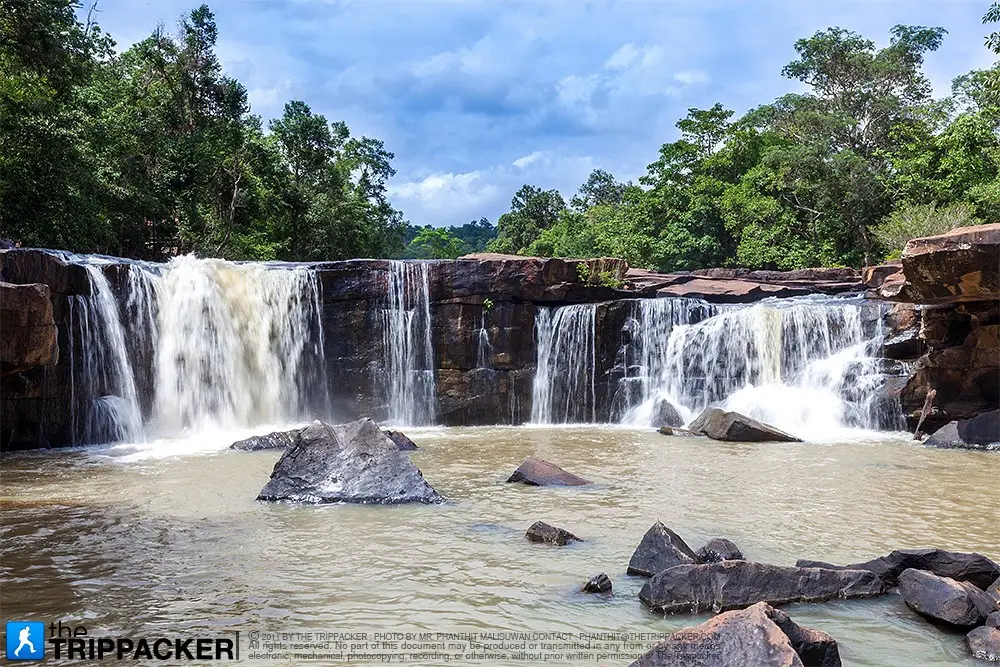
Tat Ton Waterfall, Mukdahan: A Broad Sandstone Cascade Surrounded by Shaded Forest in Nong Sung. Tat Ton Waterfall is located near Ban Non Yang in Non Yang Subdistrict, Nong Sung District, Mukdahan Province. The natural cascade is approximately 7 metres high and 30 metres wide. Water spreads across a broad sandstone ledge before descending into a pool where swimming is possible when water conditions are safe. The surrounding landscape consists of mixed deciduous and dry dipterocarp forest, creating a shaded setting for relaxation, picnicking, photography, and nature observation. Water flows during most of the year but becomes lower in the dry season. From Nong Sung District Office, follow Highway 2042 toward Kuchinarai District in Kalasin Province for approximately 3 kilometres. Between kilometre markers 67 and 68, turn right and continue for about 400 metres.
Tat Ton Waterfall is one of the principal natural attractions of Nong Sung District and has one of the broadest waterfall faces in Mukdahan Province. It does not descend as a narrow stream from an extremely high vertical cliff. Instead, water spreads across a sandstone edge approximately 30 metres wide before dropping toward the pool below. During the rainy season, the contrast between white water, dark wet rock, and green forest produces the site’s most impressive scenery.
The waterfall lies in the rural landscape of Non Yang Subdistrict, where gently undulating land alternates with low valleys and natural forest. Its position only a few kilometres from the district centre makes it suitable for a convenient half-day or day trip. Visitors do not need a four-wheel-drive vehicle or a long forest trek under normal conditions. The final approach from the main road is approximately 400 metres.
The principal drop is approximately 7 metres high. When water reaches the ledge, it follows natural grooves and changes in the slope of the sandstone. Some sections form a thin curtain, while others concentrate into stronger channels or flow across lower rock steps. The waterfall therefore looks different according to the volume of water passing through the system.
During periods of heavy flow, white water can cover much of the 30-metre rock face. When the flow becomes lower, the underlying sandstone, joints, channels, and natural terraces are more visible. Travelers should set their expectations according to the season rather than assuming that the waterfall will have the same appearance throughout the year.
Tourism descriptions often present Tat Ton as a broad main cascade, while Thailand’s natural-environment database records it as a small two-level waterfall. These descriptions are compatible. From the main viewpoint, one broad cliff dominates the scene, but closer examination of the stream reveals lower rock steps and minor changes in level within the same waterfall area.
A natural pool lies below the principal drop and is widely used for swimming and cooling off. The depth and current change with rainfall, upstream conditions, and the season. A place that was shallow on a previous visit may be deeper or faster on another day. Visitors should use only sections approved by the caretaker and should remain away from the direct impact of the falling water.
Although Tat Ton carries water through most of the year, this does not mean that the broad curtain remains equally strong every month. Continuous rain produces the widest flow, loudest sound, and greatest spray. During the dry season, water is generally restricted to the principal channels. The upstream reservoir and surrounding forest help retain moisture within the local catchment.
The principal rock at the waterfall is sandstone, a sedimentary rock common in many northeastern Thai landscapes. Sandstone forms from accumulated sand and sediment that are gradually compressed and cemented together. When flowing water encounters layers with different levels of resistance, softer sections erode more quickly than harder sections, eventually producing a ledge and drop.
Water continues to alter the waterfall every year. It enters small cracks, carries sand across the surface, and moves loose rock through the channels. Over a long period, this action deepens grooves, rounds exposed edges, and enlarges pools. The process is slow from a human perspective but remains an active part of the natural landscape.
Rock surfaces that appear smooth and stable can be extremely slippery. Thin algae grow on areas that remain wet and may be almost invisible against the sandstone. Secure closed footwear or water shoes with effective grip are recommended. Flat sandals, running on the ledges, and jumping between wet rocks significantly increase the risk of falling.
The surrounding vegetation consists of mixed deciduous and dry dipterocarp forest. Mixed deciduous forest contains several species of seasonally leaf-shedding trees, together with shrubs, vines, and lower vegetation. Dry dipterocarp forest is adapted to shallow soils, high temperatures, and a long dry season. Many trees have thick bark and durable leaves.
Recorded tree species include tabaek, payom, Siamese rosewood, takhian, pradu, daeng, mafai, makha, chingchan, krabok, krabak, san, chik, tio, wild champaca, yom hom, hiang, teng, and rang. These trees provide more than shade. Their roots hold soil in place, fallen leaves add organic matter, and the canopy reduces the direct force of rain before water reaches the ground.
During the rainy season, the forest becomes bright green and lower vegetation expands rapidly. Moisture encourages moss, fungi, and seasonal plants around rocks and tree bases. In the cool season, conditions become drier and some leaves begin to change colour. By the late dry season, the dry dipterocarp forest becomes more open and the landscape takes on brown and golden tones.
The forest provides habitat for birds, butterflies, insects, reptiles, and other wildlife. Environmental records describe a broader variety of animals within the surrounding natural area, but visitors should not expect guaranteed sightings. Most wildlife avoids busy recreation zones. Travelers are more likely to hear birds or notice tracks than to encounter larger animals directly.
Early morning is the best time for quiet nature observation. Visitors should walk slowly, avoid loudspeakers, and keep an appropriate distance from nests or wildlife. Binoculars make it possible to observe birds without leaving the path or disturbing their feeding and breeding behaviour.
Tat Ton Waterfall is officially recognised as a natural site worthy of conservation under a Thai Cabinet resolution dated 7 November 1989. This status reflects its geological, ecological, recreational, and educational importance. Tourism development should therefore support public access while protecting the sandstone ledge, watercourse, forest, and visual character of the site.
Conservation status does not prevent responsible recreation. Visitors may swim, rest, and take photographs while following local regulations. However, carving names into rock, removing plants or stones, leaving rubbish, and moving boulders to create private pools damage the natural area and should not occur.
A reservoir is located above the waterfall and forms part of the local water-management system. It collects water from the catchment and is connected to the flow passing through the waterfall. Visitors must use only publicly accessible sections and should not approach gates, control structures, or restricted operational areas.
The visitor area can be understood through several zones. The first includes the entrance and parking area near the Non Yang Subdistrict Administrative Organization. A walking route continues through shaded vegetation toward the upper stream and rock platform. The main cascade, swimming pool, shaded recreation area, and forest surroundings form the remaining principal zones.
The entrance and parking zone is the appropriate place to prepare for the visit. Vehicles should remain in designated spaces and must not obstruct government access, pedestrian routes, or emergency vehicles. Drinking water, medication, towels, dry clothing, secure footwear, and a bag for carrying rubbish should be checked before leaving the vehicle.
A developed path provides access to the waterfall, but it remains a route within a natural landscape. Wet ground, leaves, soil, and slopes may be present. Older visitors should move slowly and use support where required. Young children should not run ahead because they may reach slippery rock or moving water before an adult.
The upper stream and rock platform reveal the path of the water before it reaches the main drop. The current may look shallow at a distance, but it becomes faster near the edge. Visitors should not stand above the waterfall, attempt to cross the stream close to the drop, or use the upper platform as a shortcut.
The main waterfall viewpoint provides the clearest view of the 30-metre width. During strong flow, water spreads across most of the cliff and creates spray around the pool. Photographers should remain on stable ground and should never step backward without checking the surface. Tripods must not block paths or resting areas.
The pool below the cascade is the principal swimming zone. Conditions must be assessed on the day of travel. Water can rise after rain, the falling cascade can push swimmers away from secure footing, and underwater grooves may not be visible from the surface. Weak swimmers should remain in shallow sections and avoid the direct base of the waterfall.
Children should wear properly fitted flotation equipment and remain within immediate reach of an adult. An inflatable toy is not a substitute for a life jacket. An adult should maintain direct attention rather than watching from a distant picnic area, because a child can slip or be moved by the current within seconds.
The shaded recreation area is suitable for picnics and rest. Mats should be placed without blocking circulation and away from any channel that could carry rising water. Hammocks should not be attached to young trees, and nails must not be driven into trunks. Visitors should also avoid resting beneath dead or damaged branches.
Food stalls and shops may operate near the entrance during popular periods, but their availability varies according to the day and season. Travelers should carry sufficient drinking water and essential food rather than depending entirely on local businesses, particularly on weekdays, early mornings, or during periods of low visitor numbers.
The best period for viewing a broad and powerful waterfall generally extends from July to November. Frequent rain supplies the stream, refreshes the forest, and reduces the temperature around the rocks. This period also brings greater risk from slippery surfaces, thunderstorms, and rapidly changing water levels.
A flash flood can result from rain falling in the upper catchment even when no rain is falling directly over the waterfall. Warning signs include rapidly darkening water, a sudden rise in level, an unusual increase in noise, and branches or debris moving quickly downstream. Visitors must leave the water immediately and move to higher ground.
October and November often provide a useful balance between good water volume and fewer periods of continuous heavy rain. The forest remains green, temperatures are moderate, and the waterfall is generally photogenic. Current weather and local access information should still be checked before departure.
The cool season from November to February is suitable for picnicking, walking, and observing the forest. Mornings can be pleasantly cool and mist may form in low areas. The water volume gradually decreases as the dry season progresses. Swimmers should prepare towels and dry clothing because cool air can reduce body temperature quickly after leaving the pool.
From March to May, the waterfall has less water than during the rainy season. More sandstone may be exposed, and some parts of the cliff can become dry. The shaded forest remains useful for relaxation, but travelers should arrive early, carry sufficient drinking water, and should not expect a full-width curtain of water.
A practical arrival time is between 08.30 and 10.30. The weather is cooler and visitors have sufficient time to select a resting place. Two to four hours are generally enough for viewing, swimming, eating, and walking around the area. Belongings should be packed before the 16.30 closing time.
Weekdays are usually quieter and suitable for photography or peaceful relaxation. Weekends and public holidays bring more families and groups. Early arrival improves parking and access to shaded areas. Large groups should share the space and should avoid using loud music.
Swimming should begin only after checking the current conditions or instructions displayed by the caretaker. Old photographs cannot confirm that a pool is safe today. Visitors must enter from stable ground, avoid diving into water of unknown depth, and never jump from rocks or use ropes to swing into the pool.
Alcohol and swimming are an unsafe combination. Alcohol reduces balance, judgement, and reaction speed. Glass bottles should not be taken near the pool because broken glass is extremely difficult to remove from rock crevices and creates long-term danger.
Picnic food should be stored in closed, reusable containers. Reducing foam boxes, small plastic bags, and loose packaging prevents rubbish from entering the water. Food scraps, oil, soup, and drinks must not be poured into the stream or left for animals.
Soap, shampoo, detergent, and dishwashing liquid should not be used in the waterfall or stream. Even products labelled biodegradable can affect aquatic organisms and water quality. Washing should take place only in an appropriate facility outside the natural watercourse.
Environmental monitoring has previously noted rubbish along the approach route. Every group should carry a waste bag, inspect its resting place, and remove everything it brought into the area. Small items such as bottle caps, straws, and elastic bands can be carried deep into rock gaps and remain for years.
The waterfall can be photographed from several perspectives. A frontal position captures its full width, while a side angle reveals the slope and layering of the sandstone. Morning light is generally soft. After rain, wet rock has richer colour and the leaves appear brighter, but the ground is also more slippery.
Cameras and phones should have straps and waterproof protection. Slow-shutter photography can be carried out from stable, dry ground. There is no need to place a tripod in the current. Portrait subjects should not stand at the upper edge or on wet, exposed rocks.
Drone operation requires permission from the Non Yang Subdistrict Administrative Organization or the local caretaker. Pilots must also comply with Thai registration and aviation rules, avoid flying directly above visitors, respect privacy, and prevent disturbance to birds and other wildlife.
Families should prepare water shoes, dry clothes, towels, drinking water, basic medicine, and appropriate flotation equipment for children. A clear meeting point should be agreed upon. If a child becomes separated, the caretaker should be informed immediately rather than having group members search in uncoordinated directions.
Older travelers and people with knee problems can enjoy the easier viewpoints and shaded areas without entering every part of the pool. Shoes should have effective grip, and assistance may be required on slopes. Anyone experiencing pain, dizziness, or unusual fatigue should stop and rest.
People with open wounds, skin infections, or reduced immunity should avoid swimming in natural water. Visitors with medical conditions should carry prescribed medicine and ensure that companions understand any necessary emergency response. Phones should remain in waterproof protection.
In an accident, a person with a possible head, neck, or bone injury should not be moved unless the current position is immediately dangerous. The caretaker should be contacted, the exact location should be explained, and the route should be cleared for assistance. A basic first-aid kit is useful for cleaning and covering minor injuries.
Getting There from Nong Sung District Office is straightforward. Follow Highway 2042 toward Kuchinarai District in Kalasin Province for approximately 3 kilometres. Between kilometre markers 67 and 68, look for the waterfall sign, turn right, and continue for approximately 400 metres to the entrance and parking area.
The final approach passes through a community area. Drivers should reduce speed and watch for pedestrians, motorcycles, agricultural vehicles, children, and animals. Vehicles should not be parked on bends, in front of homes, or in locations that restrict local access.
Online navigation users should search for “Tat Ton Waterfall Nong Sung Mukdahan” and confirm that the destination is in Non Yang Subdistrict. Thailand has several waterfalls named Tat Ton, including the well-known national park in Chaiyaphum Province. Selecting the wrong map result can produce a journey hundreds of kilometres away.
Travelers arriving from Mukdahan city can follow Highway 12 toward Nong Sung District and then continue on Highway 2042. Fuel should be checked before exploring rural attractions, particularly when the itinerary includes other communities and viewpoints beyond the waterfall.
A private or rented vehicle is the most convenient transport option. Regular public transport does not provide dependable service directly to the entrance. Travelers without a vehicle should arrange a hired car from Nong Sung and agree on both the fare and pickup time before departure.
A half-day itinerary can begin at 08.30 in central Nong Sung. After the short drive, visitors can spend two or three hours at the waterfall before returning to the district centre for lunch. This plan is suitable for families and older travelers and avoids rural driving after dark.
A full-day route can begin with Tat Ton in the morning, followed by lunch and visits to the Phu Thai community of Ban Nong O, Phra That Champa, Wat Banphot Khiri or Phu Chor Ko, and Ban Phu Homestay. Travelers with additional time can continue to the Mukdahan wind farm viewpoint during the afternoon.
Ban Nong O provides opportunities to learn about Phu Thai language, clothing, food, weaving, and local traditions. Visitors should request permission before photographing residents and should support community producers by purchasing locally made textiles, food, or handicrafts.
Phra That Champa can be included in the same district itinerary. Wet swimming clothes should be changed before entering a Buddhist site. Visitors should dress appropriately, speak quietly, and respect any restricted religious areas.
Wat Banphot Khiri, also associated with Phu Chor Ko, occupies a higher and quieter landscape and has connections with Thailand’s forest-monk tradition. Sufficient travel time should be allowed, and mountain routes should be avoided during severe rain or close to darkness.
Ban Phu Homestay offers community-based experiences involving Phu Thai culture, local food, handicrafts, and rural life. Meals and overnight stays should be reserved in advance because the community requires time to prepare hosts, ingredients, and activities.
Restaurants and cafés are distributed through central Nong Sung, Ban Phu, and the route toward the wind farm. Small businesses may change opening days according to season and local circumstances. Calling before a group meal or holiday visit is recommended.
Accommodation near the waterfall includes small resorts and community homestays. Staying in Nong Sung is useful for travelers wishing to avoid a rushed schedule or continue toward Kalasin and the wider Phu Phan region. Reservations should confirm room availability, check-in time, breakfast, parking, and other required services.
The Non Yang Subdistrict Administrative Organization is the principal local caretaker, working with the Ban Non Yang community. Its role includes maintaining access roads, parking, paths, cleanliness, and public order. The caretaker can restrict swimming or close a section whenever water or weather conditions become unsafe.
Normal visiting hours are 08.30 to 16.30. Visitors should leave the pool early enough to collect belongings, change clothing, and return to the parking area before closing. Hours can be modified because of heavy rain, flooding, maintenance, community events, or emergencies.
Tat Ton is not an officially designated overnight campground. Tents should not be erected without permission. Travelers seeking an overnight nature experience should use a registered homestay or resort in Nong Sung, where food, sanitation, and assistance are more readily available.
Keeping Tat Ton clean is a shared responsibility. A single piece of litter can be carried into the pool, broken into smaller fragments, and remain within the ecosystem for a long period. Everything brought into the waterfall should leave with the visitor.
Responsible tourism also involves respecting the community. Drivers should move slowly through villages, avoid blocking homes or agricultural access, and obtain permission before photographing residents at close range. Spending money with local restaurants, accommodation providers, and producers helps retain tourism income in Nong Sung.
Tat Ton is an effective outdoor classroom. Visitors can observe how sandstone produces a waterfall ledge, how an upper reservoir relates to downstream flow, how dry dipterocarp trees survive seasonal drought, and how forest cover protects a catchment. School groups should coordinate with the local administration in advance.
Although the waterfall is close to the road and district centre, it remains a natural water site rather than a controlled swimming park. Visitors must assess their own ability, observe water changes, and avoid unnecessary risks. Responsible judgement is the most important safety measure.
The appeal of Tat Ton comes from the combination of a broad rock face, natural pool, forest shade, and easy access. It can be enjoyed as a short family outing or as the starting point for a full cultural route through Phu Thai communities, temples, homestays, and elevated viewpoints.
When water is abundant, a white curtain across the 30-metre cliff creates the most dramatic scene. When water is low, the sandstone layers and channels become more visible. Both conditions offer different opportunities for nature observation, provided that travelers understand the season before visiting.
The most rewarding visit is unhurried and respectful. Drive carefully through the community, walk through the forest, swim only where conditions are safe, enjoy food without leaving rubbish, and depart within the operating hours. This approach allows travelers to experience Nong Sung’s natural landscape while helping preserve Tat Ton Waterfall for the community and future visitors.
| Name | Tat Ton Waterfall, Mukdahan |
| Thai Name | น้ำตกตาดโตน จังหวัดมุกดาหาร |
| Location | Ban Non Yang, Non Yang Subdistrict, Nong Sung District, Mukdahan Province |
| Address | Non Yang, Nong Sung District, Mukdahan 49160, Thailand |
| Coordinates | 16.4947, 104.3131 |
| Place Type | Natural waterfall, sandstone platform, swimming pool, and conserved forest area |
| Waterfall Dimensions | Approximately 7 metres high and 30 metres wide |
| Waterfall Character | A broad sandstone ledge with natural channels and lower rock steps; water spreads across the cliff during periods of strong flow |
| Number Of Levels | One dominant broad drop with lower rock steps; the official natural-environment database records two small levels |
| Water Conditions | Water flows during most of the year, with stronger flow in the rainy season and lower flow in the dry season |
| Geology | Sandstone eroded into a cliff, channels, rock platforms, and a natural pool |
| Terrain | An undulating plain between low valleys in Nong Sung District |
| Forest Types | Mixed deciduous and dry dipterocarp forest |
| Important Tree Species | Tabaek, payom, Siamese rosewood, takhian, pradu, daeng, makha, chingchan, krabok, krabak, chik, tio, wild champaca, yom hom, hiang, teng, and rang |
| Conservation Status | Natural site worthy of conservation under the Thai Cabinet resolution dated 7 November 1989 |
| Main Areas And Zones | 1. Entrance and parking area 2. Waterfall access path 3. Upper reservoir and catchment area 4. Upper stream and sandstone platform 5. Main waterfall cliff 6. Lower swimming pool 7. Shaded recreation area |
| Activities | Nature viewing, swimming in safe areas, photography, picnicking, bird observation, plant study, and geological learning |
| Open Days | Daily |
| Opening Hours | 08.30 – 16.30. Access may be limited during heavy rain, flooding, or unsafe conditions. |
| Admission Fee | Free admission |
| Facilities | Concrete access road, parking, waterfall path, recreation areas, and seasonal food or drink vendors near the entrance |
| Best Visiting Period | July–November for stronger flow; November–February for cooler outdoor conditions |
| Safety | Beware of slippery rock, rising water after rain, underwater grooves, and the current below the drop. Do not jump from rocks or approach the upper edge. |
| Travel Information | From Nong Sung District Office, follow Highway 2042 toward Kuchinarai for approximately 3 km. Between kilometre markers 67 and 68, turn right and continue for approximately 400 metres. |
| Caretaker | Non Yang Subdistrict Administrative Organization and the Ban Non Yang community |
| Main Contact Number | Non Yang Subdistrict Administrative Organization: +66 42 635 292 |
| Official Website | https://nonyang.go.th/ |
| Current Status | Open during normal visiting hours. Swimming and access to individual zones depend on the water level, weather, and caretaker instructions. |
| Nearby Tourist Attractions | 1. Ban Nong O Phu Thai Community, approximately 5 km 2. Phra That Champa, approximately 7 km 3. Wat Banphot Khiri or Phu Chor Ko, approximately 11 km 4. Ban Phu Homestay And Phu Thai Cultural Learning Centre, approximately 13 km, Tel. +66 81 047 4218 5. Mukdahan Wind Farm, approximately 18 km, Tel. +66 95 740 5660 |
| Nearby Restaurants | 1. Café Amazon Nong Sung Branch, approximately 5 km, Tel. +66 63 445 4466 2. Suan Kiri Nakhon, approximately 6 km, Tel. +66 81 061 3490 3. 1995 Home & Cafe, approximately 6 km 4. Ban Phu Homestay Local Meals By Advance Reservation, approximately 13 km, Tel. +66 81 047 4218 5. Mukdahan Wind Farm Cafe, approximately 18 km, Tel. +66 85 853 9158 |
| Nearby Accommodations | 1. Natalie Resort, approximately 7 km, Tel. +66 86 229 5202 2. Kaeng Luang Resort, approximately 7 km, Tel. +66 89 621 2314 3. Dolpha Resort, approximately 8 km, Tel. +66 81 967 1438 4. Ban Pao Homestay, approximately 12 km, Tel. +66 81 048 1102 5. Ban Phu Homestay, approximately 13 km, Tel. +66 81 047 4218, +66 87 230 1599 |
Frequently Asked Questions (FAQ)
Q: Where is Tat Ton Waterfall in Mukdahan?
A: It is located near Ban Non Yang in Non Yang Subdistrict, Nong Sung District, approximately 3 kilometres from Nong Sung District Office.
Q: What are the opening hours?
A: The waterfall is normally open daily from 08.30 to 16.30. Access may be limited during heavy rain, flooding, maintenance, or unsafe conditions.
Q: Is there an admission fee?
A: Admission is free. Visitors pay only for food, drinks, or other services they choose to use.
Q: Does Tat Ton Waterfall have water throughout the year?
A: Water flows during most of the year, but the volume decreases during the dry season. July to November generally offers the broadest flow and greenest forest.
Q: Can visitors swim at Tat Ton Waterfall?
A: Swimming is possible in the pool and sections opened by the caretaker. Visitors should avoid deep water, slippery rocks, restricted areas, and the direct base of the cascade.
Q: Is the waterfall suitable for children and older travelers?
A: It is suitable for family recreation, but children require direct adult supervision. Older travelers should use stable resting areas and avoid wet rocks.
Q: How do travelers reach Tat Ton Waterfall?
A: From Nong Sung District Office, follow Highway 2042 toward Kuchinarai. Between kilometre markers 67 and 68, turn right and continue for approximately 400 metres.
Q: Which nearby attractions can be visited on the same day?
A: A practical route can include Ban Nong O Phu Thai Community, Phra That Champa, Wat Banphot Khiri, Ban Phu Homestay, and the Mukdahan wind farm viewpoint.
 Category: ●Nature and Wildlife
 Group: ●Waterfalls
Last Update : 2 MonthAgo
 Last Update : 2 MonthAgo
 Click to Access the Navigation Map GPS
Tat Ton Waterfall Map
Recommend

 Art, Culture and Heritage
 Historical Sites and Monuments(2)
 Landmarks and Memorials(3)
 Art, Craft Centres, Tradition(2)
 Museums(1)
 Places of Worship
 Temple(17)
 Other Sacred Sites(3)
 Suburban Living
 Village, Community(4)
 Local Market(2)
 National Parks and Marine Reserves(4)
 Mountain (Doi)(5)
 Dam, Reservoir, Lake(3)
Waterfalls(5)
Dam, Reservoir, Lake(3)
Waterfalls(5)
 Caves(2)
 River, Canal(2)
 Bays and Beaches(1)
 Other natural attractions(1)
 Entertainment and Agricultural
 Farms, Parks and Ecotourism(1)


