
lovethailand home >North Travel Attractions >Tak Travel Attractions >Um Phang >Mae Chan > Pi Tu Gro Waterfall
TL;DR: Pi Tu Gro Waterfall, Tak attractions : Nature and Wildlife, Waterfalls.

Pi Tu Gro Waterfall

Open Days: Accessible depending on the travel season, weather, trail conditions, and the management of Ban Kui Loe To community-based tourism
Opening Hours: Visitors should begin in the morning according to schedules arranged by the local community or experienced local operators
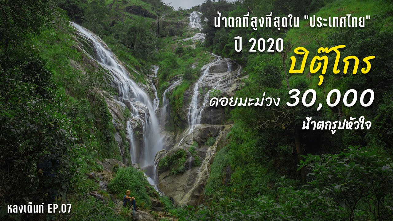
Pi Tu Gro Waterfall in Tak Province is one of the most remarkable forest waterfalls in Umphang District. Widely known among Thai trekkers as the “Heart-Shaped Waterfall”, it is famous for its two major streams flowing down a high mountain cliff and forming a heart-like shape when viewed from the right distance. This waterfall is not a casual roadside attraction. It is a remote trekking destination that requires preparation, local guidance, physical readiness, and respect for the community and natural environment.
Pi Tu Gro Waterfall is located in the area of Ban Kui Loe To, Mae Chan Subdistrict, Umphang District, Tak Province, near Doi Mamuang Sam Muen and the Thai–Myanmar border region. The surrounding landscape consists of high mountains, forested slopes, community farmland, streams, and humid mountain forest. Because of its location, visiting the waterfall is best understood as a trekking and eco-travel experience rather than a simple sightseeing trip.
The name “Pi Tu Gro” comes from the Pga K’nyau language. “Pi Tu” refers to a hut, while “Gro” refers to a stream. The meaning reflects the local geography and the cultural context of the area, where forest, water, settlement, and traditional community life are closely connected. For this reason, the name of the waterfall is not only a tourism label but also a local name rooted in the language and landscape of Ban Kui Loe To.
The waterfall is formed by streams flowing from the Doi Mamuang Sam Muen mountain range, descending over high rock cliffs into the forested valley below. From a distance, the white streams appear to divide and curve into a heart-like shape against a green mountain backdrop. This shape is most visible during the rainy season, especially from June to October, when the water volume is high and the surrounding forest is at its most vivid.
Pi Tu Gro is often described as a waterfall of more than 500 meters in height. While measurements of remote waterfalls can vary depending on method and reference point, what visitors clearly experience is the impressive scale of the cliff, the long continuous flow of water, and the dramatic mountain setting. The waterfall feels especially powerful after a long walk through forest and farmland, when the sound of falling water gradually becomes louder before the waterfall itself comes into view.
The journey usually begins in Umphang town. From there, travelers continue by vehicle toward Ban Kui Loe To, the main community gateway to the trekking route. The distance from Umphang town to Ban Kui Loe To is approximately 60–70 km, depending on the route and road conditions. The mountain road has curves and sections that require careful driving, so travelers should allow enough time and use transport arranged by people familiar with the area.
Ban Kui Loe To is a Pga K’nyau community with a quiet way of life closely tied to mountains, forests, farmland, and streams. A trip to Pi Tu Gro is therefore also a visit to a living local community. Visitors should dress respectfully, avoid disturbing homes and agricultural areas, follow local rules, and use local guides. This approach helps support community income and allows tourism to remain connected with local responsibility.
The trekking route from Ban Kui Loe To to Pi Tu Gro passes through natural and community landscapes. The first sections often include village paths, cornfields, dirt tracks, streams, and open slopes before entering wetter and more forested terrain. The walk to the campsite is commonly around 5 km and may take about 1–3 hours depending on fitness, weather, trail conditions, and backpack weight. From the campsite, travelers continue walking toward the waterfall for another section.
The trail can be slippery, muddy, and uneven, especially during the rainy season. Good trekking shoes with strong grip are essential. A walking stick can also help with balance on muddy slopes, stream crossings, and wet rock sections. As the trail approaches the waterfall area, the environment becomes more humid and forested, with roots, stones, narrow paths, and steep sections. Travelers should walk slowly, keep a safe distance, and avoid rushing.
Most visitors arrange Pi Tu Gro as a 2-day 1-night or 3-day 2-night trip. A longer itinerary is more comfortable because it allows time for travel from Umphang, trekking, camping, visiting the waterfall, and possibly climbing Doi Mamuang Sam Muen. Camping near the waterfall area gives travelers a closer experience of the forest atmosphere, but all overnight stays should follow local arrangements and environmental rules. Waste should be packed out, and the campsite should be left clean.
Doi Mamuang Sam Muen is another highlight often combined with Pi Tu Gro. The mountain rises to around 1,600 meters above sea level and offers views of ridges, forest, and surrounding highland landscapes. The trail to the summit is steep and narrow in places, including ridge sections that require caution. Travelers who plan to climb the summit should be physically prepared and should follow the guidance of local guides at all times.
The best time to see the heart-shaped appearance of Pi Tu Gro is during the rainy season and early cool season. During the rainy months, the waterfall is fuller, the forest is greener, and mist often adds atmosphere to the valley. However, the same season also brings slippery trails, mud, leeches, and sudden rain. Travelers should bring waterproof bags, rain protection, leech protection, quick-dry clothing, and spare dry items packed separately.
Preparation is crucial because there are limited facilities along the trail. Travelers should bring food, drinking water, quick-dry clothing, proper trekking shoes, a rain jacket, a headlamp, waterproof storage, personal medication, pain relief, basic first aid items, insect repellent, leech protection, and a bag for carrying all rubbish back out. Packing light but adequately is important because some parts of the route may involve stream crossings, mud, and long walking hours.
Local porters and guides play an important role in the Pi Tu Gro trekking route. They help lead the way, support campsite organization, assist with safety, and help carry some group equipment. However, porters may be limited during busy travel periods. Travelers should plan ahead and be prepared to carry personal belongings themselves. Supporting local guides and porters fairly helps the community maintain the route and manage tourism more sustainably.
Travelers should not attempt to visit Pi Tu Gro without someone who knows the area. The route can be confusing in wet weather, and some sections may change after rain or erosion. A local guide helps reduce the risk of getting lost, assists with trail decisions, and ensures that the trip follows community rules. This is especially important in a remote mountain environment where mobile signal and emergency access may be limited.
Pi Tu Gro is a genuine eco-travel destination. Visitors should stay on the designated route, avoid breaking branches, never collect plants or stones, never wash with soap or shampoo in streams, and avoid making loud noise. Food scraps and rubbish should not be left behind. Responsible behavior is essential because the waterfall and its surrounding forest are sensitive natural areas that depend on respectful tourism.
For photographers, Pi Tu Gro offers one of the most memorable natural scenes in Thailand. The two white streams forming a heart-like shape against green forest create a powerful image, especially during the rainy season. However, photography should never come before safety. Visitors should avoid slippery rocks, steep edges, and unsafe viewpoints. Camera gear and phones should be protected from rain and mist with waterproof bags or dry sacks.
The charm of Pi Tu Gro is also found in the gradual journey toward the waterfall. Visitors do not simply arrive and take a photo. They pass through a community, farmland, streams, forest, mud, and mountain air before reaching the final viewpoint. This effort gives the waterfall more meaning. The beauty of Pi Tu Gro is not only in its shape but also in the sense of earning the view through patience and respect for the landscape.
Culturally, the waterfall is closely connected with Ban Kui Loe To and the Pga K’nyau way of life. The community helps coordinate tourism, provide guides, and preserve local knowledge about the route. Visitors should see themselves as guests of both nature and the community. Polite behavior, respect for local rules, and fair use of community services all help make tourism more balanced and beneficial.
Pi Tu Gro is suitable for travelers with some trekking experience, or for beginners who are well prepared and travel with experienced local support. It is not suitable for travelers who require high comfort, those unable to walk on wet and slippery terrain for several hours, or those unwilling to camp in basic natural conditions. Group leaders should honestly assess the fitness and health of all members before the trip.
What makes Pi Tu Gro stand out among other natural attractions is the combination of a large waterfall, heart-shaped streams, high mountains, community culture, a trekking route, forest camping, and Doi Mamuang Sam Muen. A well-planned trip can offer both natural beauty and a deeper understanding of Umphang’s highland landscape.
Before traveling, visitors should contact Ban Kui Loe To community-based tourism or experienced local operators to check the latest access status, travel season, group limits, guide availability, porter availability, weather, campsite conditions, and required equipment. Arriving without coordination may result in difficulty finding a guide or accessing the route, especially during popular travel periods.
Pi Tu Gro Waterfall is more than a beautiful waterfall. It is a test of preparation, patience, and respect for nature. Those who reach it are rewarded with the heart-shaped waterfall, memories from the forest trail, and a deeper appreciation of how fragile and valuable remote natural destinations can be. Traveling responsibly is the best way to keep Pi Tu Gro beautiful for future visitors.
| Name | Pi Tu Gro Waterfall |
| Location | Ban Kui Loe To, Mae Chan Subdistrict, Umphang District, Tak Province |
| Address | Ban Kui Loe To Area, Mae Chan Subdistrict, Umphang District, Tak 63170, Thailand |
| Highlights | A large waterfall with two major streams falling from a cliff in a heart-like shape, earning the nickname “Heart-Shaped Waterfall” |
| History | A trekking destination developed through Ban Kui Loe To community-based tourism and increasingly popular among nature and trekking travelers |
| Name Origin | The name comes from the Pga K’nyau language: “Pi Tu” refers to a hut, and “Gro” refers to a stream |
| Distinctive Features | Water flows from the Doi Mamuang Sam Muen mountain range and separates into two white streams that resemble a heart during the rainy season |
| Travel Information | From Umphang town, travel about 60–70 km to Ban Kui Loe To. From there, trek about 5 km to the campsite and continue on foot to the waterfall. Visitors should travel with local guides or experienced operators. |
| Current Status | A natural trekking route managed by the local community. Access depends on season, weather, trail conditions, and community arrangements. |
| Open Days | Accessible depending on the travel season, weather, trail conditions, and Ban Kui Loe To community-based tourism management |
| Opening Hours | Visitors should begin in the morning according to schedules arranged by the local community or experienced local operators |
| Facilities | Prepare food, drinking water, trekking gear, and personal supplies before reaching Ban Kui Loe To. Facilities along the trail are limited. |
| Main Areas / Zones | Ban Kui Loe To, trailhead, stream trail, campsite, Pi Tu Gro Waterfall, and connecting route to Doi Mamuang Sam Muen |
| Caretaker / Local Coordinator | Ban Kui Loe To community-based tourism and local guides in Mae Chan Subdistrict, Umphang District |
| Main Contact Number | Tourism Authority of Thailand, Tak Office, Tel. 055-514341, 055-514342, 055-514343 |
| Official Website / Official Page | Ban Kui Loe To Pi Tu Gro Waterfall Community-Based Tourism |
| Nearby Tourist Attractions | 1. Ban Kui Loe To, about 0 km from the trailhead 2. Pi Tu Gro Campsite, about 5 km from the trailhead 3. Doi Mamuang Sam Muen, about 9–10 km from the campsite 4. Thi Lo Su Waterfall, about 40 km from Umphang town 5. Doi Hua Mot, about 10 km from Umphang town |
| Nearby Restaurants | 1. Ban Khru San Umphang, about 60–70 km from Ban Kui Loe To 2. Khrua Khon Ban Hao Umphang, about 60–70 km from Ban Kui Loe To 3. Khrua Pa Ni Umphang, about 60–70 km from Ban Kui Loe To 4. Cheewa Doi Umphang, about 60–70 km from Ban Kui Loe To 5. Nong Kung Restaurant Umphang, about 60–70 km from Ban Kui Loe To |
| Nearby Accommodations | 1. Umphangburi Resort, about 60–70 km from Ban Kui Loe To, Tel. 055-561576, 063-9894555 2. Thee Lor Su Riverside Resort, about 60–70 km from Ban Kui Loe To, Tel. 089-8321455, 089-0165666 3. Ban Khru San Guesthouse, about 60–70 km from Ban Kui Loe To 4. Umphang Country Hut, about 60–70 km from Ban Kui Loe To 5. Umphang Riverside Resort, about 60–70 km from Ban Kui Loe To |
Frequently Asked Questions (FAQ)
Q: Where is Pi Tu Gro Waterfall located?
A: Pi Tu Gro Waterfall is located in the Ban Kui Loe To area, Mae Chan Subdistrict, Umphang District, Tak Province, near Doi Mamuang Sam Muen and the Thai–Myanmar border region.
Q: Why is Pi Tu Gro called the Heart-Shaped Waterfall?
A: Its two main streams fall from a high cliff and create a heart-like shape when viewed from the right angle, especially during the rainy season when the water flow is strong.
Q: How many days are needed for Pi Tu Gro Waterfall?
A: Travelers should plan at least 2 days and 1 night. Many trips are arranged as 3 days and 2 nights to allow enough time for trekking, camping, visiting the waterfall, and possibly climbing Doi Mamuang Sam Muen.
Q: Who is Pi Tu Gro Waterfall suitable for?
A: It is suitable for trekkers, adventure travelers, and physically prepared visitors who can walk on muddy, slippery, and uneven natural trails with limited facilities.
Q: When is the best time to visit Pi Tu Gro Waterfall?
A: The rainy season to early cool season is best for seeing the waterfall at its most beautiful. The rainy season shows the heart shape clearly, while the late rainy to early cool season often offers more comfortable trekking conditions.
Q: Is a local guide required?
A: A local guide is strongly recommended because the route passes through natural terrain, streams, slippery sections, and community-managed areas. Guides help with safety and local rules.
Q: What should travelers prepare?
A: Travelers should prepare non-slip trekking shoes, quick-dry clothing, rain protection, waterproof bags, a headlamp, personal medication, insect repellent, leech protection, food, drinking water, and a bag for carrying rubbish out.
Q: Can Pi Tu Gro Waterfall be visited as a day trip?
A: A day trip is not recommended because the journey involves traveling from Umphang to Ban Kui Loe To and trekking for several hours. An overnight plan is safer and more suitable.
 Category: ●Nature and Wildlife
 Group: ●Waterfalls
Last Update : 6 MonthAgo
 Last Update : 6 MonthAgo
 Click to Access the Navigation Map GPS
Pi Tu Gro Waterfall Map
Recommend

 Art, Culture and Heritage
 Historical Sites and Monuments(2)
 Landmarks and Memorials(3)
 Art, Craft Centres, Tradition(6)
 Historic Homes and Cities(2)
 Educational Places
 Educational Gardens, Farm(2)
 University
 Rajamangala University of Technology(1)
 Places of Worship
 Temple(22)
 Other Sacred Sites(9)
 Research and Development
 Royal Project(1)
 Suburban Living
 Village, Community(5)
 Local Market(3)
 National Parks and Marine Reserves(11)
 Mountain (Doi)(9)
 Dam, Reservoir, Lake(14)
Waterfalls(23)
 Hot Springs(2)
 Caves(6)
 River, Canal(1)
 Bays and Beaches(1)
 Islands(1)
 Other natural attractions(1)
 Entertainment and Agricultural
 Farms, Parks and Ecotourism(5)
 Outdoor and Adventure Activities(4)
 Shopping
 Department Store(1)
 Travel Articles, Recipes
 Travel Review, Food Review(2)


