
lovethailand home >North Travel Attractions >Chiang Mai Travel Attractions >Wiang Haeng >Saen Hai > Wat Phra That Saen Hai
TL;DR: Wat Phra That Saen Hai is located at Ban Maha That, Saen Hai Subdistrict, Wiang Haeng District, Chiang Mai Province 50350, Thailand, open Daily, hours 08.00 – 17.00.
Wat Phra That Saen Hai
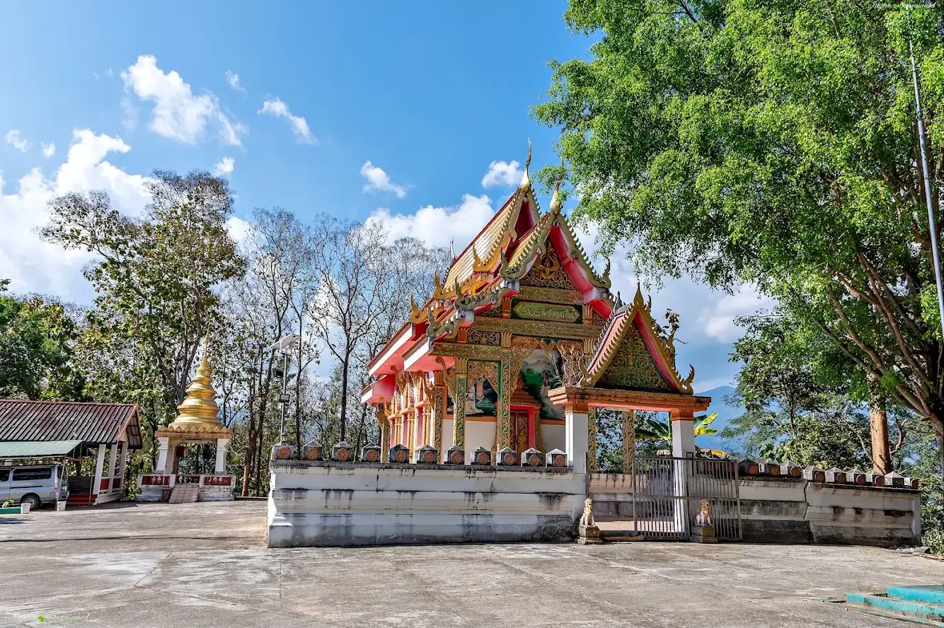
Open Days: Daily
Opening Hours: 08.00 – 17.00
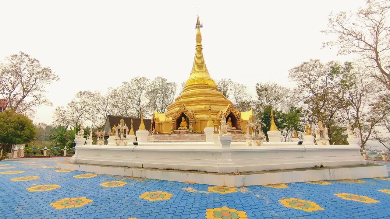
Wat Phra That Saen Hai, also widely known as Wat Phra Borom That Saen Hai, is one of the most sacred Buddhist sites in Wiang Haeng District, Chiang Mai Province. Located in Ban Maha That, Saen Hai Subdistrict, the temple is regarded as the spiritual heart of Wiang Haeng and the principal sacred stupa of the district. The golden stupa stands on a hill above the village and is built in an octagonal form that blends Shan, Burmese, and Lanna artistic influences. For local residents, visiting Wiang Haeng without paying respect to Phra Borom That Saen Hai is often described as not truly having arrived in Wiang Haeng.
Wat Phra That Saen Hai is a public Buddhist temple under the Maha Nikaya order, registered under temple code 350200301. It remains an active religious site and continues to appear in contemporary temple and Kathin databases. The temple is therefore not an abandoned ruin but a living Buddhist place where local people continue to worship, hold ceremonies, and gather for important community traditions.
The temple is located in Ban Maha That, Saen Hai Subdistrict, Wiang Haeng District, Chiang Mai Province 50350. Its approximate coordinates are 19.62022, 98.62806, at an elevation of around 738 metres above sea level. The setting is a mountain basin landscape of villages, farmland, streams, the Mae Taeng River, and surrounding hills. This gives the temple a distinctly rural highland atmosphere, very different from the major urban temples of Chiang Mai city.
Ban Maha That is directly connected with the temple's identity. The village was formerly part of Ban Pang Po, but as the population grew, residents separated to form a new village. Because the sacred stupa stood within the settlement area, the community became known as Ban Maha That. The village name itself therefore reflects the central role of Phra That Saen Hai in local identity.
In earlier times, villagers lived on lowland areas near the Mae Taeng River, but repeated flooding caused residents to move onto higher ground east of the river. The placement of the stupa on a hill makes it both a religious center and a landmark in the cultural landscape. It can be understood as a sacred point linking faith, settlement, agriculture, and the surrounding mountain environment.
Ban Maha That includes related settlement areas such as Ban Santisuk, a Shan community. The village lies about 11 kilometres north of central Wiang Haeng and includes residential areas, agricultural land, and water-management systems. Residents cultivate rice, garlic, chili, soybeans, mangoes, lychees, and seasonal vegetables, using local streams, ponds, and irrigation systems to support farming.
Local tradition holds that Phra Borom That Saen Hai is an ancient stupa dating back to the time of the Buddha and containing relics of the Buddha. This belief is central to local faith. From the community perspective, the stupa is not merely an architectural monument but a sacred reliquary that has protected and united the people of Wiang Haeng across generations.
The stupa visible today was substantially restored in B.E. 2457, equivalent to 1914. The restoration covered an older, smaller stupa. The current form has an octagonal base, a gilded body, and a high finial. Its design reflects Shan and Burmese influences adapted into a Lanna context, creating a style that belongs very naturally to this borderland area of northern Chiang Mai.
The stupa measures approximately 48 metres around its base and approximately 21 metres from the ground to the top of the finial. The octagonal base gives the structure visual stability, while the golden upper form and spire make it stand out against the surrounding trees and mountains.
The temple is also associated with local historical traditions concerning King Naresuan. Community narratives link the area with the king's final military campaign toward Ava, saying that he may have passed through or rested near Phra Borom That Saen Hai. A historic water source below the stupa, known as Bo Nam Chang or the Elephant Well, is traditionally associated with water used for the king and war elephants.
These Naresuan-related traditions are important to the cultural memory of Wiang Haeng. The temple and surrounding area continue to host commemorative activities connected with King Naresuan, making the site a place where Buddhist devotion and local historical memory overlap.
The name Saen Hai also carries several local explanations. One tradition links it with a large number of jars used in ritual memory, while another connects the name with the phrase Saen Hai, meaning countless weeping voices, in relation to the grief associated with King Naresuan traditions. Whatever explanation is followed, the name has become inseparable from the stupa, the subdistrict, and the shared identity of local residents.
The first place visitors should focus on is the golden octagonal stupa itself. The stupa stands on a hill with a staircase leading upward, creating a gradual approach that suits the act of worship. From the upper area, visitors can see the temple compound, village setting, trees, and surrounding mountain landscape.
The base of the stupa and its surrounding shrines reveal the temple's borderland artistic character. Gilded surfaces, small Buddha images, decorated niches, and Shan-Burmese visual elements all contribute to the distinctive appearance of the site. The stupa is not a standard central-Chiang-Mai Lanna form, but a local expression shaped by the cultural exchange between Lanna, Shan, and Burmese Buddhist traditions.
The Elephant Well below the hill adds another important layer to the visit. It connects the sacred stupa with the historical imagination of the community and demonstrates that the temple landscape includes more than the stupa alone. The surrounding paths, water sources, and ritual areas all contribute to the meaning of the site.
The temple's most important annual tradition is the Phra Borom That Saen Hai water-pouring ceremony. This ceremony is held according to the northern lunar calendar and brings together villagers, local government, schools, monks, and devotees from across Wiang Haeng. Water is carried in procession to the stupa, the stupa is circumambulated, and sacred water is offered at the base as an act of devotion.
The water-pouring ceremony is more than a single religious ritual. It renews the relationship between the community and its sacred reliquary. Families, young people, elders, and local institutions all participate, turning the event into a visible expression of shared identity.
Other major religious occasions at the temple include Magha Puja on the fifteenth waxing moon of the northern fifth month, Visakha Puja on the full moon of the eighth month, and Songkran on April 13. These four annual observances keep the temple active throughout the year and provide regular opportunities for local people to return to the district's principal sacred site.
The 2026 Saen Hai municipal activity calendar continued to list the annual Phra That Saen Hai water-pouring ceremony, confirming that the tradition remains active in the present day. Schools in Wiang Haeng have also participated in recent ceremonies, demonstrating that the tradition is still being passed to younger generations.
The temple plays a central role in the identity of Saen Hai Subdistrict. The area includes both Northern Thai and Shan communities, agricultural households, water-management systems, and Buddhist traditions. Phra Borom That Saen Hai acts as a shared sacred center where people from multiple villages can gather and express a common sense of belonging.
Ban Maha That's agricultural landscape also helps explain the temple. The village uses ponds and irrigation systems, including small local weirs, to support farming. Water is therefore important not only economically but also ritually, appearing in both agricultural life and the annual ceremony of pouring water over the stupa.
Visitors should dress respectfully, covering shoulders and knees, remove shoes in designated areas, and avoid climbing on the stupa base or touching sacred objects without permission. During ceremonies, visitors should allow monks, procession groups, elders, and local residents to complete their rituals without obstruction.
The best times to visit are morning and late afternoon. The weather is more comfortable, the light is suitable for photography, and the hilltop setting is quieter. Travelers seeking cultural atmosphere should visit during the annual water-pouring ceremony or Songkran, while those seeking silence should come on ordinary weekdays outside major festival periods.
Nearby places that can be combined with Wat Phra That Saen Hai include Wat Si Don Chai, Wat Uthai Tha Ram, Wat Muang Pok, Wat Sam Phu, Mae Lat Waterfall, and Wat Phra That Wiang Haeng. These sites help travelers understand the religious and natural landscape of Saen Hai and Mueang Haeng more completely.
Mae Lat Waterfall is a useful natural stop for travelers who want to add forest scenery to the itinerary. Located in the Ban Sam Pu area, the waterfall is associated with a multi-level natural landscape. Seasonal conditions should be checked before visiting, especially during heavy rain.
Food options near Saen Hai include Mon Pun Saen Hai, Meedee Bakery, Lung Nao Khao Man Kai, Wianghaeng 321 Small Bar, and additional restaurants in central Mueang Haeng. Mon Pun Saen Hai is especially useful because it combines food, accommodation, and viewpoint scenery.
Accommodation is available in Saen Hai and Mueang Haeng. Mon Pun Saen Hai offers rooms, bungalows, and camping space in a scenic location. Other options include Wianghaeng Countryhills, Chiang Tung Rooms, Kru Ae Homestay, Muang Haeng Resort & Spa, and smaller guesthouses in the district center.
Getting There from Chiang Mai city is easiest by private car or rental vehicle. Follow Highway 107 toward Chiang Dao, then continue onto the road into Wiang Haeng District via Highway 1322. From Ban Mueang Ngai, the mountain route toward Wiang Haeng is approximately 55 kilometres. Continue to Ban Maha That in Saen Hai Subdistrict.
The route includes mountain curves and elevation changes, so brakes, tyres, fuel, and lights should be checked before departure. Daytime driving is recommended, especially for travelers unfamiliar with the road. During the rainy season, fog, wet surfaces, and water crossing sections may require extra caution.
A half-day itinerary can include Wat Phra That Saen Hai, Wat Uthai Tha Ram, Wat Si Don Chai, and Wat Muang Pok. A full-day route can add Mae Lat Waterfall, Wat Phra That Wiang Haeng, Wat Wiang Haeng, or Wat Kong Lom. With two days and one night, travelers can spend the first day in Saen Hai and Mueang Haeng, then continue toward Piang Luang the next day.
Wat Phra That Saen Hai is especially suitable for travelers interested in sacred stupas, Shan-Lanna art, northern Buddhist festivals, King Naresuan local traditions, and community-based cultural travel. Its significance comes from the way the stupa, village, river, hill, ceremony, and historical memory all converge in one place.
Viewed in full context, Phra Borom That Saen Hai is far more than a hilltop stupa. It is the cultural heart of Wiang Haeng, a major annual pilgrimage site, a symbol of Saen Hai identity, and a living sacred place where local history, faith, agriculture, water, and mountain landscape remain closely connected.
| Name | Wat Phra That Saen Hai / Wat Phra Borom That Saen Hai |
| Temple Type | Public Buddhist Temple, Maha Nikaya Order |
| Temple Registry Code | 350200301 |
| Location | Ban Maha That, Saen Hai Subdistrict, Wiang Haeng District, Chiang Mai Province 50350, Thailand |
| Coordinates | 19.62022, 98.62806 |
| Elevation | Approximately 738 Metres Above Sea Level |
| Importance | Principal sacred stupa and spiritual center of Wiang Haeng District |
| Historical Background | Local tradition regards the stupa as ancient; the present form was substantially restored in B.E. 2457 / 1914 over an older smaller stupa |
| Stupa Form | Shan-Burmese And Lanna-Influenced Octagonal Stupa, Approximately 48 Metres Around The Base And 21 Metres High To The Finial |
| What To See | Golden Octagonal Stupa, Hilltop Worship Area, Surrounding Shrines, And The Elephant Well At The Foot Of The Hill |
| Community Connection | Ban Maha That is named after the sacred stupa, and the temple functions as the main religious and cultural center of Saen Hai |
| Major Annual Events | 1. Phra Borom That Saen Hai Water-Pouring Ceremony 2. Magha Puja, Fifteenth Waxing Moon Of The Northern Fifth Month 3. Visakha Puja, Full Moon Of The Eighth Month 4. Songkran, April 13 |
| Current Status | Active Registered Maha Nikaya Temple With Continuing Annual Religious Traditions |
| Open Days | Daily |
| Opening Hours | 08.00 – 17.00 |
| Contact | 053-248-604, 053-248-607 |
| Travel Information | Travel From Chiang Mai Via Highway 107 And Chiang Dao, Then Continue Onto Highway 1322 Toward Wiang Haeng And Ban Maha That. Private Car Or Rental Vehicle Is Recommended. |
| Nearby Tourist Attractions | 1. Wat Si Don Chai, About 1 km 2. Wat Uthai Tha Ram, About 2 km 3. Wat Muang Pok, About 4 km 4. Wat Sam Phu, About 5 km 5. Mae Lat Waterfall, About 12 km 6. Wat Phra That Wiang Haeng, About 14 km |
| Nearby Restaurants & Cafes | 1. Mon Pun Saen Hai, About 5 km, Tel. 081-407-8497 2. Meedee Bakery, About 6 km, Tel. 085-232-8419 3. Lung Nao Khao Man Kai, About 7 km, Tel. 082-896-1292 4. Wianghaeng 321 Small Bar, About 8 km, Tel. 093-241-8264 5. Pa Khin Restaurant, About 13 km, Tel. 089-854-9071 |
| Nearby Accommodations | 1. Mon Pun Saen Hai, About 5 km, Tel. 081-407-8497 2. Wianghaeng Countryhills, About 8 km, Tel. 080-790-4587 3. Chiang Tung Rooms, About 13 km, Tel. 053-477-251, 089-835-4932, 082-895-6271 4. Kru Ae Homestay, About 14 km, Tel. 087-179-4631 5. Muang Haeng Resort & Spa, About 14 km |
Frequently Asked Questions (FAQ)
Q: Where is Wat Phra That Saen Hai located?
A: Wat Phra That Saen Hai is located in Ban Maha That, Saen Hai Subdistrict, Wiang Haeng District, Chiang Mai Province 50350, at approximately 19.62022, 98.62806.
Q: Why is Wat Phra That Saen Hai important?
A: It is regarded as the principal sacred stupa and spiritual center of Wiang Haeng District, closely connected with Ban Maha That, Saen Hai Subdistrict, and major annual religious ceremonies.
Q: What does the stupa look like?
A: The stupa has an octagonal base and reflects Shan, Burmese, and Lanna artistic influences. It measures approximately 48 metres around the base and about 21 metres high to the finial.
Q: When is the annual water-pouring ceremony held?
A: The ceremony is held annually according to the northern lunar calendar and remains the temple's most important community religious event.
Q: How is the temple connected with King Naresuan?
A: Local traditions connect the temple and nearby Elephant Well with King Naresuan's final campaign route and the historical memory of Wiang Haeng.
Q: What are the opening hours?
A: The temple opens daily from 08.00 to 17.00. Visitors should dress respectfully and observe temple etiquette.
Q: What nearby places can be visited with Wat Phra That Saen Hai?
A: Nearby places include Wat Si Don Chai, Wat Uthai Tha Ram, Wat Muang Pok, Wat Sam Phu, Mae Lat Waterfall, and Wat Phra That Wiang Haeng.
Q: What type of traveler will appreciate Wat Phra That Saen Hai?
A: It is ideal for travelers interested in sacred stupas, Shan-Lanna art, northern Buddhist traditions, local history, and community-based cultural travel in Wiang Haeng.
 Category: ●Places of Worship
 Group: ●Temple
Last Update : 2 MonthAgo
 Last Update : 2 MonthAgo
 Click to Access the Navigation Map GPS
Wat Phra That Saen Hai Map
Recommend

 Muang Chiang Mai(121)Chom Thong(47)Mae Chaem(25)Chiang Dao(33)Doi Saket(68)Mae Taeng(85)Mae Rim(69)Samoeng(29)Fang(71)Mae Ai(59)Phrao(70)San Pa Tong(103)San Kamphaeng(66)San Sai(73)Hang Dong(73)Hot(32)Doi Tao(22)Omkoi(11)Saraphi(74)Wiang Haeng(15)Chai Prakan(28)Mae Wang(32)Mae On(22)Doi Lo(33)Galyani Vadhana(1)


