
lovethailand home >South Travel Attractions >Yala Travel Attractions >Ban Nang Sata >Ba Cho > Bang Lang Dam
TL;DR: Bang Lang Dam is located at Ban Bang Lang, Khuean Bang Lang Subdistrict, Bannang Sata District, Yala Province, open Daily, hours 09.00 – 18.00.

Bang Lang Dam
Open Days: Daily
Opening Hours: 09.00 – 18.00
Bang Lang Dam in Yala Province is the first multipurpose dam in southern Thailand. Located in Ban Bang Lang, Khuean Bang Lang Subdistrict, Bannang Sata District, it dams the Pattani River and serves several major functions: hydropower generation, irrigation support, flood mitigation, freshwater fisheries, and tourism. The main visitor highlights are the dam crest, reservoir viewpoint, mountain scenery, Hala-Bala forest landscape, Khun Saichol Villa accommodation, and boat trips across the reservoir.
Bang Lang Dam is one of Yala Province’s most important landmarks, combining energy, water management, local livelihoods, nature, and travel in one destination. The dam is located at Ban Bang Lang, Khuean Bang Lang Subdistrict, Bannang Sata District, Yala Province, on the Yala-Betong travel route. It is about 58 km from Yala city along Highway 410, followed by another 12 km on the access road into the dam area. Because of its location, Bang Lang Dam is a practical scenic stop for travelers heading from Yala toward Bannang Sata, Than To, Aiyerweng, and Betong.
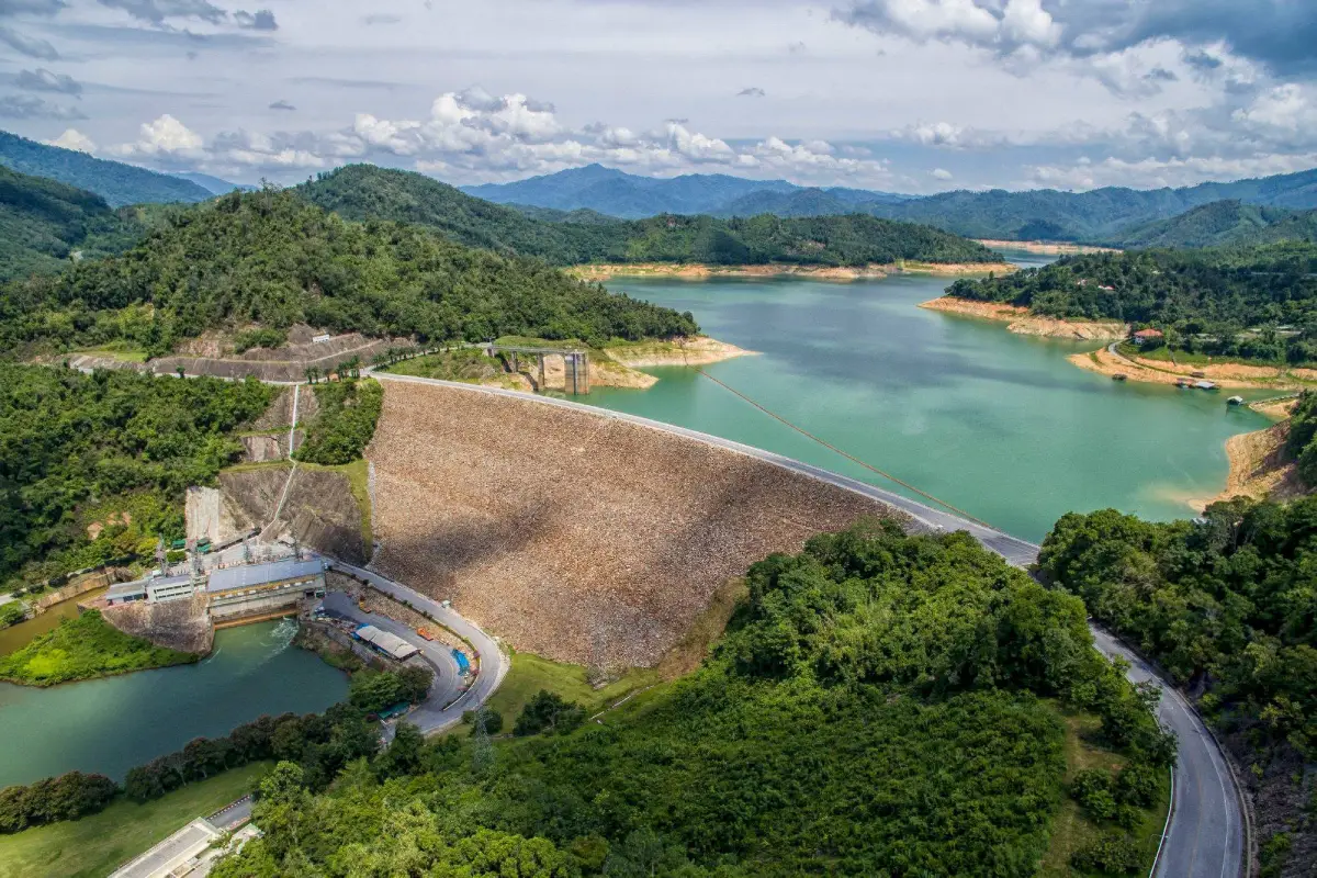
Bang Lang Dam is recognized as the first multipurpose hydropower project in southern Thailand. It was developed by the Electricity Generating Authority of Thailand as part of the Pattani River Basin development plan. The dam is a clay-core rockfill dam built across the Pattani River. It stands 85 meters high from its foundation, has a crest length of 430 meters, a crest width of 10 meters, and a reservoir storage capacity of 1,420 million cubic meters. These dimensions make the dam both a major water infrastructure project and one of the most dramatic landscapes in Yala.
The project began with surveys and planning by the Electricity Generating Authority of Thailand to meet the region’s electricity demand and improve water management in the southern provinces. The Thai Cabinet approved the construction of Bang Lang Hydropower Project on 3 April 1973. Construction started in July 1976 and was completed in June 1981. The dam was officially opened on 27 September 1981 by His Majesty King Bhumibol Adulyadej The Great, together with Her Majesty Queen Sirikit The Queen Mother and Her Royal Highness Princess Maha Chakri Sirindhorn.
The importance of Bang Lang Dam extends well beyond electricity generation. As a multipurpose dam, it supports the water system of the Pattani River Basin. The reservoir stores water for irrigation, supports agricultural areas in Yala and Pattani, helps reduce flooding in the lower Pattani River Basin, and serves as an important freshwater fishery in southern Thailand. Water released from the dam is also used to generate electricity for households and industry across the region.
The Bang Lang Hydropower Plant plays a role in southern Thailand’s energy security. The power station is a reinforced concrete structure with a total installed generation capacity of 72 MW and an estimated annual electricity output of about 289 million kilowatt-hours. The project demonstrates efficient use of water as a renewable resource: the same water system can store water, support irrigation, reduce flood impact, sustain fisheries, attract tourism, and generate clean hydropower.
A related highlight in the Bang Lang area is Ban Santi Hydropower Plant. It was developed from a royal initiative to use overflow water from the Bang Lang Dam weir for local benefit. EGAT responded by constructing a small underground hydropower plant at Ban Santi 1, Cho Subdistrict, Bannang Sata District, in 1981. The plant uses a 1.275 MW generator and an 1,800-meter water pipe, and began supplying electricity in October 1982. This adds another layer to Bang Lang’s importance as both a large dam and a local energy-development area.
For most travelers, the lasting image of Bang Lang Dam is the wide reservoir surrounded by green mountains and the humid tropical forest of Hala-Bala. The viewpoint above the dam offers a panoramic view of the dam crest, reservoir, access road, surrounding hills, and forested ridges. On clear days, the water appears blue-green against the mountains. After rain or in humid morning conditions, mist often drifts above the reservoir and hill slopes, creating a calm and highly photogenic atmosphere.
The main visitor areas include the dam crest, scenic pavilion, reservoir viewpoint, EGAT office and power-plant area, Khun Saichol Villa accommodation, Ruen Balae Restaurant, meeting facilities, and the boat pier for reservoir trips. Some parts of the dam remain operational areas for hydropower and water management. Visitors should stay within the areas open to the public, follow signage, and avoid entering power-plant or engineering zones without permission.
The viewpoint is the best place to understand the scale of Bang Lang Dam. From this area, visitors can see the reservoir, the dam road, the curved embankment, rows of palms, and the surrounding mountain scenery. Morning visits are ideal for fresh air, soft light, and misty views. Late afternoon visits give warm light across the water and hills, making the landscape more dimensional for photography.
One of Bang Lang Dam’s most distinctive travel experiences is a boat or raft trip across the reservoir. The upper reservoir connects with the Hala-Bala lake landscape, forested waterways, islands, and mountain scenery. Travelers can contact local boat services at the Bang Lang Dam pier to explore the water more closely. Popular reservoir experiences include viewing the forested shoreline, calm water, mountain reflections, and small islands such as Popcorn Island, which is reached by boat from the dam pier.
The reservoir landscape is linked to Hala-Bala, one of the most biodiverse forest areas in southern Thailand. The broader area is known for tropical rainforest, rare plants, and wildlife such as hornbills, rhinoceros hornbills, great hornbills, gaur, barking deer, wild boar, monkeys, langurs, and smooth-coated otters. Some boat routes and nearby forest areas also connect with waterfalls and streams flowing into the lake. This gives the reservoir trip a stronger ecological character than a typical sightseeing cruise.
Bang Lang Dam is suitable for families, older travelers, photographers, students, and visitors who prefer quiet nature over crowded attractions. Families can enjoy the viewpoint, food stops, and accommodation inside the dam area. Travelers who want a deeper experience can stay overnight at Khun Saichol Villa, arrange a boat trip, and continue to nearby nature attractions. Anyone planning a boat trip should confirm weather conditions, operating times, passenger numbers, and safety equipment in advance.
For students, researchers, writers, and travelers interested in energy or environmental management, Bang Lang Dam is a strong real-world case study. It shows how a single dam can serve multiple public functions at once: generating electricity, storing water, supplying irrigation, reducing flood damage, supporting freshwater fisheries, and creating a tourism landscape. Visiting the dam helps travelers understand how water infrastructure can shape local economies and everyday life in Yala and Pattani.
The atmosphere around Bang Lang Dam is different from many other dams in Thailand because it sits within the deep southern border landscape. The journey along Highway 410 gradually shifts from Yala city to forested hills, valleys, and mountain roads. The route is scenic, especially as it approaches Bannang Sata and the dam area. Travelers who enjoy road trips will find this section rewarding, with green ridges, curves, reservoir views, and quiet rural scenery.
A good one-day itinerary starts from Yala city in the morning. Drive along Highway 410 toward Bannang Sata, visit the Bang Lang Dam viewpoint, photograph the reservoir and dam crest, then have lunch either in the dam area or in Bannang Sata. In the afternoon, choose between a reservoir boat trip or continuing to nearby natural attractions such as La-ong Rung Waterfall, Than To Waterfall, Hala-Bala Lake, or Bang Lang National Park. This route combines dam scenery, forest, water, and local communities in a single day.
For travelers continuing to Betong, Bang Lang Dam is an excellent rest stop before the longer mountain section. Many road travelers stop here to take photos and enjoy the reservoir before continuing toward Than To, Aiyerweng Skywalk, and Betong town. The stop breaks up the journey, adds a meaningful scenic element, and gives visitors a clearer sense of Yala’s geography before heading deeper into the southern mountain border region.
The best time to visit Bang Lang Dam is morning or late afternoon, when the weather is more comfortable and the light is better for viewing the reservoir. The rainy season makes the hills intensely green and can create beautiful mist, but drivers should check road and weather conditions before departure. During wet weather, visitors should avoid slippery slopes, soft ground near the water, and any restricted structures around the dam.
Visitors should dress comfortably and behave respectfully because Bang Lang Dam is both a tourist attraction and an operational EGAT facility. Comfortable walking shoes, drinking water, sun protection, and a small trash bag are useful. Photography should be kept to visitor areas, and travelers should avoid disrupting staff, entering restricted areas, or photographing operational zones where access is not permitted.
Khun Saichol Villa at Bang Lang Dam is the main accommodation inside the dam area. The property offers several guesthouse types, including Ban Sri Yala, Ban Kritsana, and Ban Champa units. Staying inside the dam area gives visitors a quiet natural setting close to the viewpoint and boat pier. Travelers should contact Khun Saichol Villa directly to confirm room availability, room type, booking conditions, and the latest visitor information before traveling.
Dining options near the dam include restaurants inside the EGAT area and local restaurants in Bannang Sata. Ruen Balae Restaurant is a convenient choice within the dam area, while Muslim restaurants and local eateries in Bannang Sata are useful for travelers who want halal food or a meal along the Yala-Betong route. Planning meal stops in advance is recommended because the area is not as densely served as Yala city.
Nearby attractions can be grouped by travel style. For the closest experience, focus on the dam crest, viewpoint, boat pier, and Popcorn Island. For nature, continue to La-ong Rung Waterfall, Than To Waterfall, Hala-Bala Lake, or Bang Lang National Park. For a longer scenic route, continue toward Aiyerweng Skywalk and Betong. This makes Bang Lang Dam a useful anchor point for planning a Yala-Betong nature itinerary.
Travelers should understand the difference between public visitor areas and operational dam areas. The crest, viewpoint, guesthouse, restaurant, meeting areas, and pier are visitor-oriented spaces, while parts of the hydropower plant, control structures, and engineering facilities are restricted. Follow all signs and staff instructions, and do not climb over barriers or enter areas that are not open to visitors.
As a travel destination, Bang Lang Dam helps visitors understand Yala beyond its urban center and better-known Betong route. It represents the Pattani River Basin development plan, southern energy security, agricultural water management, flood mitigation, freshwater fisheries, and nature-based tourism. Seen from this wider perspective, Bang Lang Dam is not only a viewpoint; it is a key landscape where water, energy, forest, and community life meet.
Getting There from Yala city is straightforward by private car, rental car, or local hired vehicle. Take Highway 410 toward Bannang Sata on the Yala-Betong route. The distance from Yala city to the dam area is about 58 km, then turn off near Ban Kasot and continue another 12 km to the dam. Travelers without a private vehicle can use the Yala-Betong public transport route and arrange local transport into the dam area. Drivers should check fuel, weather, and road conditions, especially during the rainy season.
Overall, Bang Lang Dam deserves a place in any Yala travel plan. It combines mountain scenery, a large reservoir, Hala-Bala forest views, an important hydropower project, accommodation, dining, and boat activities. Visitors can make a short stop for photos, spend half a day around the viewpoint and pier, or stay overnight to enjoy the reservoir landscape more slowly. For travelers seeking a deeper view of Yala’s nature, history, infrastructure, and southern border way of life, Bang Lang Dam is one of the province’s most meaningful destinations.
| Name | Bang Lang Dam |
| Location | Ban Bang Lang, Khuean Bang Lang Subdistrict, Bannang Sata District, Yala Province |
| Address | 33 Moo 1, Sri Bang Lang Road, Khuean Bang Lang Subdistrict, Bannang Sata District, Yala 95130, Thailand |
| Coordinates | Latitude 6.15639, Longitude 101.27361 |
| Highlights | Southern Thailand’s first multipurpose dam, reservoir viewpoint, Hala-Bala mountain scenery, dam crest, guesthouse, and reservoir boat trips |
| History | Approved by the Thai Cabinet on 3 April 1973, construction began in July 1976, completed in June 1981, and officially opened on 27 September 1981 |
| Dam Type | Clay-core rockfill dam, 85 m high, 430 m crest length, 10 m crest width, and 1,420 million cubic meters reservoir capacity |
| Power Plant | Hydropower plant with a reinforced concrete powerhouse, total capacity of 72 MW, and estimated annual generation of about 289 million kWh |
| Importance | Hydropower generation, irrigation support, flood mitigation in the lower Pattani River Basin, freshwater fisheries, and tourism in Yala Province |
| Name Origin | Named after the Bang Lang area where the dam was built across the Pattani River in Bannang Sata District, Yala Province |
| Distinctive Features | Large mountain reservoir, Hala-Bala forest scenery, scenic dam crest, viewpoint, and boat routes across the reservoir |
| Travel Information | From Yala city, take Highway 410 toward Betong for about 58 km, then turn near Ban Kasot and continue about 12 km to the dam |
| Current Status | Active EGAT hydropower dam, water-management facility, scenic viewpoint, guesthouse area, and tourism site |
| Open Days | Daily |
| Opening Hours | 09.00 – 18.00 |
| Facilities | Viewpoint, guesthouse, restaurant, meeting rooms, boat pier, and parking areas at visitor-service points |
| Main Areas / Zones | Dam crest, scenic pavilion, upper reservoir, EGAT office and power-plant area, Khun Saichol Villa, Ruen Balae Restaurant, meeting rooms, and Bang Lang Dam boat pier |
| Caretaker / Coordinating Agency | Electricity Generating Authority of Thailand, Bang Lang Dam Information officer: Mr. Pipat Jetsadanon, Head of Bang Lang Dam Power Plant Division |
| Main Contact Number | Bang Lang Dam Tel. 0-7328-1068 Visitor and meeting inquiries Tel. 073-281063 ext. 2204-5 Khun Saichol Villa Bang Lang Dam Tel. 073-2811129 Bang Lang Dam boat trip Tel. 093-785-3944 |
| Official Website / Official Page | Electricity Generating Authority of Thailand website EGAT Bang Lang Dam website Khun Saichol Villa Bang Lang Dam website EGAT Bang Lang Dam Facebook page |
| Nearby Tourist Attractions | 1. Bang Lang Dam Crest and Scenic Pavilion, about 0 km 2. Bang Lang Dam Boat Pier, about 1 km 3. Popcorn Island, Hala-Bala Lake, about 1 km from the boat pier 4. La-ong Rung Waterfall, about 9 km 5. Bang Lang National Park and Than To Waterfall, about 25 km 6. Aiyerweng Skywalk, about 50 km |
| Nearby Restaurants | 1. Ruen Balae Restaurant, about 1 km, Tel. 073-281128 2. Krua Muslim Restaurant, about 1 km, Tel. 093-6060667, 084-8907341 3. Krua Thai Balae, about 1 km 4. Ajumma Bannang Sata Branch, about 17 km, Tel. 065-404-0064 5. Sep Thang Mala Bannang Sata, about 17 km, Tel. 064-013-7095 6. Sila, about 35 km, Tel. 065-024-9454 |
| Nearby Accommodations | 1. Khun Saichol Villa Bang Lang Dam, about 0 km, Tel. 073-2811129 2. 66 Baanaisuan, about 13 km 3. Cool Camping Resort, about 17 km, Tel. 073-373-224 4. Resort Ban Saitan 21, about 32 km 5. The Linux Garden Hotel, about 43 km, Tel. 073-299-578 6. Park View Hotel Yala, about 44 km, Tel. 073-217001-5 |
Frequently Asked Questions (FAQ)
Q: Where is Bang Lang Dam located?
A: Bang Lang Dam is located in Ban Bang Lang, Khuean Bang Lang Subdistrict, Bannang Sata District, Yala Province, about 58 km from Yala city along Highway 410, followed by an access road of about 12 km.
Q: Why is Bang Lang Dam important?
A: It is the first multipurpose dam in southern Thailand and supports hydropower generation, irrigation, flood mitigation in the Pattani River Basin, freshwater fisheries, and tourism.
Q: What are the opening hours of Bang Lang Dam?
A: Bang Lang Dam is open daily from 09.00 to 18.00. Visitors who want accommodation, meeting facilities, or boat trips should contact the relevant service in advance.
Q: What can visitors do at Bang Lang Dam?
A: Visitors can enjoy the reservoir viewpoint, photograph the dam crest and mountain scenery, stay at the guesthouse, dine in the dam area, take a reservoir boat trip, and learn about hydropower and water management.
Q: Are boat trips available at Bang Lang Dam?
A: Yes. Boat trips can be arranged from the Bang Lang Dam pier to explore the reservoir, islands, and Hala-Bala forest scenery. Weather, timing, passenger capacity, and safety equipment should be confirmed before departure.
Q: Is there accommodation inside Bang Lang Dam?
A: Yes. Khun Saichol Villa Bang Lang Dam offers guesthouse accommodation inside the dam area. Travelers should call in advance to check room availability and booking conditions.
Q: When is the best time to visit Bang Lang Dam?
A: Morning and late afternoon are the best times for comfortable weather and good light. After rain or during humid mornings, the reservoir and mountains may appear especially scenic with mist.
Q: What nearby attractions can be combined with Bang Lang Dam?
A: Nearby options include the dam crest, scenic pavilion, boat pier, Popcorn Island, La-ong Rung Waterfall, Bang Lang National Park, Than To Waterfall, and Aiyerweng Skywalk.
 Category: ●Nature and Wildlife
 Group: ●Dam, Reservoir, Lake
Last Update : 2 WeekAgo
 Last Update : 2 WeekAgo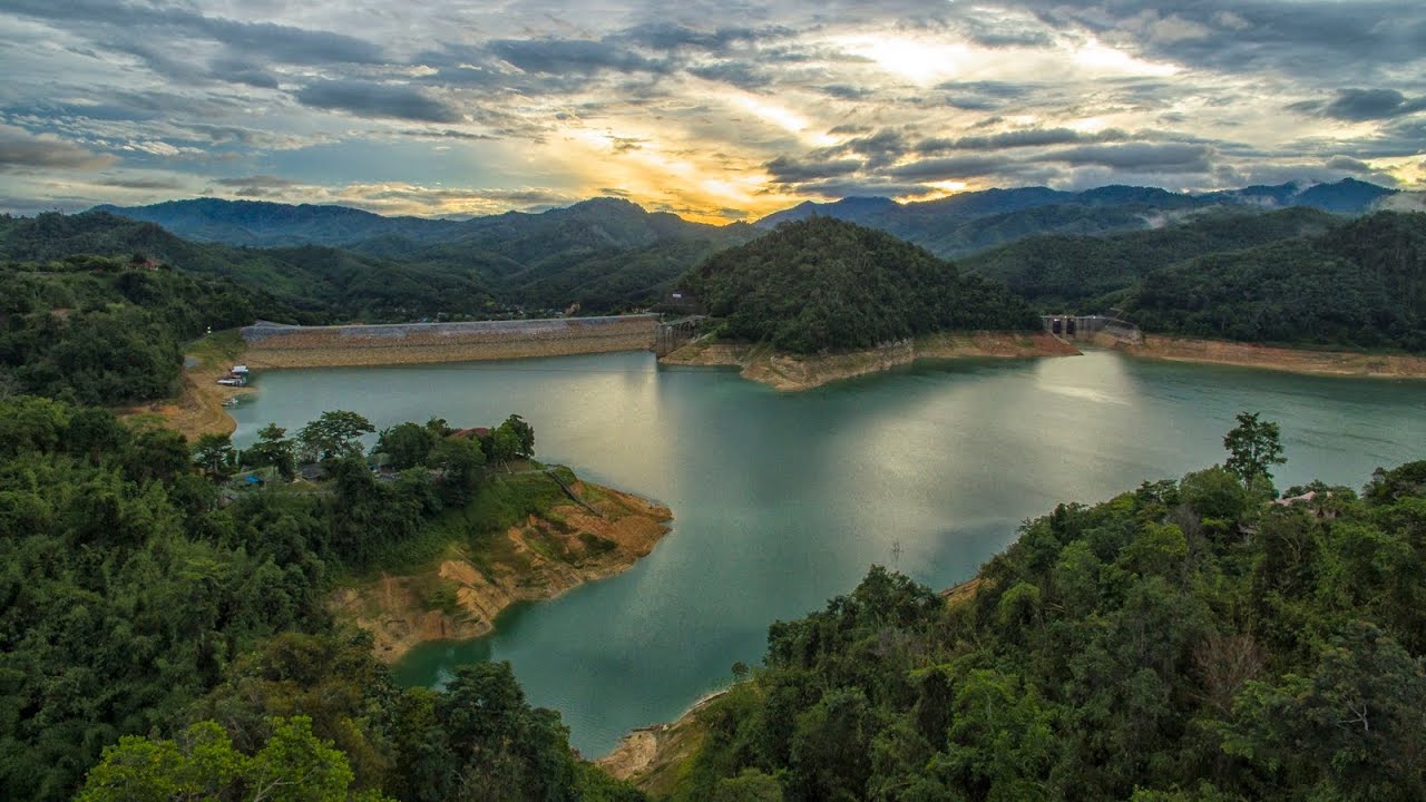
 Click to Access the Navigation Map GPS
 Art, Culture and Heritage
 Landmarks and Memorials(1)
 Art, Craft Centres, Tradition(2)
 Museums(2)
 Educational Places
 Educational Gardens, Farm(1)
 Places of Worship
 Temple(6)
 Mosque(2)
 Other Sacred Sites(3)
 Suburban Living
 Village, Community(4)
 National Parks and Marine Reserves(2)
 Mountain (Doi)(5)
Dam, Reservoir, Lake(5)
Mountain (Doi)(5)
Dam, Reservoir, Lake(5)
 Waterfalls(13)
 Hot Springs(2)
 Caves(7)
 River, Canal(4)
 Islands(1)
 Other natural attractions(8)
 Entertainment and Agricultural
 Stadium(1)
 Farms, Parks and Ecotourism(4)
 Outdoor and Adventure Activities(1)
 Travel Articles, Recipes
 Travel Review, Food Review(2)


