
lovethailand home >South Travel Attractions >Yala Travel Attractions >Be Tong >Ai Yoe Weng > Gunung Silipat Sea Of Mist
TL;DR: Gunung Silipat Sea Of Mist, Yala attractions : Nature and Wildlife, Mountain (Doi).

Gunung Silipat Sea Of Mist
Open Days: Open By Local Tour Schedule And Weather Conditions; Advance Contact Is Recommended
Opening Hours: Recommended Sea Of Mist Viewing Time 05.30 – 07.00
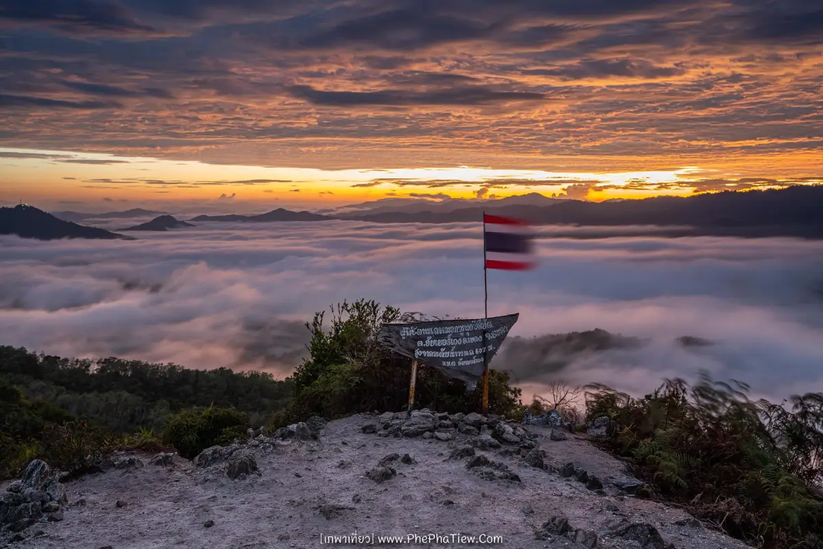
Gunung Silipat Sea Of Mist in Yala Province is one of the most striking mountain viewpoints in Betong District. It is a nature-based hiking destination for travelers who want to experience the misty mountains of Thailand’s southern border region at close range. The summit stands about 607 m above sea level. Although it is not extremely high compared with many northern Thai mountains, its strength lies in the wide 360-degree view of mist-covered valleys, layered green ridges, and the first light of sunrise over Betong’s mountain landscape. For many visitors, Gunung Silipat is one of the most beautiful sea of mist viewpoints in Betong.
The word “Gunung” means mountain in Malay, and the name Gunung Silipat is commonly connected with the appearance of a triangular rocky mountain. The name reflects both the physical landscape and the Malay cultural context of Betong, a border district shaped by mountains, local communities, and connections between Thailand and Malaysia. Visiting this viewpoint is therefore not only about taking photographs of mist. It is also a way to understand Betong’s terrain, language, local culture, and southern border identity.
Gunung Silipat is famous because the sea of mist can be seen during much of the year. Betong has high humidity, evergreen forest, regular rainfall, and mountain valleys that help mist form frequently. Early morning after humid or rainy nights can produce thick white mist covering the valleys around the summit. On some days the mist forms a dense cloud sea stretching toward the horizon; on other days it moves in thinner layers through the ridges. This changing atmosphere is part of the attraction, because every visit depends on real weather and natural conditions.
The experience is different from viewpoints that can be reached directly by car. Reaching the top of Gunung Silipat requires physical effort and caution. The route passes through rubber plantations, fruit gardens, forest paths, soil tracks, rocky slopes, and steep final sections. Some parts require visitors to use their hands or hold ropes installed along the trail for support. The hike is best suited to travelers with reasonable fitness, proper footwear, and readiness for wet, slippery, or uneven ground. During or after rain, the route can become much more challenging.
Tourism information from Betong Municipality describes the walking distance to the summit as about 500–700 m, depending on the route, with several routes currently used, including routes from local resorts and community tourism routes. Yala public relations information also describes a route where visitors take a four-wheel-drive vehicle from the access point for about 20 minutes, then walk around 700 m. The first 500 m passes through rubber plantations with gradual elevation gain, while the final 200 m is the steepest rocky section before the summit. Another more adventurous route involves a four-wheel-drive section of about 3 km followed by a walk of about 2 km, making it more suitable for overnight visitors and hikers.
The summit is a relatively small rocky and earthen platform. For safety and crowd management, local tourism information notes that visitor numbers should be limited to around 70–80 people per round. This is important for trip planning, especially during holidays or peak travel periods. Visitors should book in advance, coordinate with local guides or service providers, and follow the instructions of the local team. The summit area is beautiful but narrow, so crowd control directly affects safety and the quality of the viewing experience.
The best time to see the sea of mist is around 05.30–07.00. This is when the mist often remains in the valleys and sunrise begins to light the mountain horizon. Travelers who want to see sunrise with the mist must either leave very early from Betong town or stay overnight near the trailhead. Some camping areas are located below the summit and serve as bases for the early morning ascent. This option reduces the rush and gives visitors more time to prepare. A one-day trip is also possible if transport and a guide are arranged clearly in advance.
Camping is one of the reasons Gunung Silipat has become popular. Local and private service providers offer different combinations of tents, bedding, meals, basic toilets, and transport depending on the route and package. Some travelers stay overnight to watch sunset, enjoy the quiet mountain atmosphere, photograph stars on clear nights, and climb to the summit before sunrise. Others make an early morning visit from Betong town and return after viewing the mist. The best choice depends on time, budget, fitness, and preferred comfort level. Visitors should confirm updated prices, conditions, meeting points, and included services before booking.
Two commonly mentioned access options are the Km.28 route and the route near Punapa Gunung Silipat. The Km.28 route is often associated with a more adventurous style of travel, involving local four-wheel-drive transport and hiking through natural terrain. The Punapa route is used by travelers who stay near the mountain and then walk up from a closer base. Even when the walking distance is shorter, the final section remains steep and requires careful movement, especially on wet rock or muddy ground.
Essential items include closed-toe shoes or hiking shoes with good grip, flexible clothing, a rain jacket or windbreaker, a headlamp if walking before dawn, drinking water, personal medication, a waterproof bag for phones or cameras, and a long-sleeved layer for cool wind or insects. Avoid carrying unnecessary heavy luggage because some sections are steep and require the use of ropes. Overnight visitors should confirm whether tents, bedding, and meals are already included to avoid carrying more than needed.
Visitors should not hike alone or leave the designated route. Although Gunung Silipat is a well-known viewpoint, it remains a natural mountain area with steep slopes, rocks, soil paths, and slippery sections. Walking with a local guide helps reduce risk and supports proper crowd management at the summit. Visitors who fear heights or have heart, knee, respiratory, or mobility conditions should assess their readiness carefully. If the weather is unsafe, the ascent should be postponed according to local guidance.
The beauty of Gunung Silipat is closely tied to the sense of achievement. After walking through darkness, moisture, uphill paths, and rocky sections, the first view from the summit can feel deeply rewarding. A wooden summit sign and the Thai flag are among the most recognizable photo points. They have become symbols of reaching this sea of mist viewpoint and often appear in travel photographs from the mountain.
For photography, Gunung Silipat is excellent for panoramas, sunrise images, layered mountain views, mist flowing through valleys, and portraits near the summit sign or flag. The morning light changes quickly, so cameras or phones should be ready before reaching the top. Mist can open and close within minutes. Visitors should avoid blocking the trail or standing too close to exposed edges for photographs, and should share the limited summit space with others.
Ecologically, the area around Gunung Silipat belongs to a landscape of mountains, humid forest, rubber plantations, fruit gardens, and local communities. The humidity and valley terrain help create the mist that makes the site famous. The route through rubber and fruit-growing areas also shows the relationship between nature and local livelihoods in Aiyerweng and Betong. This makes the journey more than a viewpoint hike; it is a glimpse into mountain life in the southern border region.
Gunung Silipat also helps distribute tourism beyond the better-known Aiyerweng Sea Of Mist and Skywalk. Travelers who use local guides, four-wheel-drive transport, camping services, and community food providers contribute directly to local income. At the same time, mountain tourism must be managed responsibly. Visitors should not litter, damage plants, make excessive noise, or leave waste behind. Everything carried up should be brought back down.
The viewpoint can be combined with several nearby attractions in Aiyerweng and Betong. These include Aiyerweng rafting, Chalerm Phrakiat Rama IX Waterfall, Aiyerweng Sea Of Mist and Skywalk, Piyamit Tunnel, Betong Airport, the Winter Flower Garden, and central Betong attractions. A practical route is to stay in Betong town, leave early for Gunung Silipat, watch the sea of mist, continue to Aiyerweng or nearby waterfalls, and return to Betong for local food and town sightseeing.
Travelers with more time may prefer to stay near Gunung Silipat overnight. Evening may bring thin mist or sunset light over the ridges. On clear nights, the sky can be suitable for stargazing because the area has less light pollution than the town center. In the morning, visitors can climb before sunrise without a long transfer from town. This option is suitable for camping, nature photography, and a deeper mountain experience, but visitors should accept basic camping conditions such as humidity, simple bathrooms, cooler air, and possible limits on electricity or mobile signal.
Food after descending the mountain can be planned either along the Aiyerweng route or in Betong town. Betong is known for local dishes such as Betong chicken, kau yuk, stir-fried watercress, Betong noodles, dim sum, jee chong fun, and Betong grass jelly. Most well-known restaurants are in the town center, making them suitable for brunch or lunch after the hike. Some local camping packages may include dinner, breakfast, tea, coffee, or toast, but visitors should confirm inclusions before booking.
Accommodation for a Gunung Silipat trip generally falls into two categories. The first is staying near the trailhead, such as Punapa Gunung Silipat or local camping areas, which is convenient for an early summit ascent. The second is staying in Betong town, where hotel choices and restaurants are more convenient. Travelers staying in town must leave very early and arrange transport and a guide clearly to reach the viewpoint in time for the best mist.
Getting There from Betong town involves traveling toward Aiyerweng along the main mountain route, with access points around Km.28 or near Punapa depending on the booked service provider. The area is about 21 km from Betong town. From the meeting point, visitors normally continue by four-wheel-drive or local transport to the walking point, then hike to the summit. From Yala town to Betong, the distance is about 140 km along a winding mountain road, so travelers should allow enough time and plan accommodation before the early morning viewpoint trip.
A safe and worthwhile trip should begin with advance contact. Ask about the route, meeting point, departure time, updated cost, camping conditions, included equipment, and weather restrictions. Rest well before the trip and keep luggage light. Once on the route, follow the guide’s instructions because local guides understand slippery sections, steep areas, summit capacity, and the safest timing for ascent and descent.
Compared with Aiyerweng Skywalk, Gunung Silipat is more rugged and physically demanding. The Skywalk is better for visitors who want easier access and built infrastructure, while Gunung Silipat suits travelers who want to hike, climb, and experience the mountain more directly. The two destinations complement each other well. Travelers with enough time can visit both to see Betong’s sea of mist from two very different perspectives.
The charm of Gunung Silipat is not only the mist itself, but the whole journey: waking before dawn, traveling through mountain roads, hiking through soil and rock, holding ropes on steep sections, waiting for sunrise, and watching the mist move through the valleys. These moments make the viewpoint memorable. It is a destination for travelers who want to see Betong through real nature, mountain terrain, and the reward that comes only after effort.
| Name | Gunung Silipat Sea Of Mist / Khao Gunung Silipat |
| Location | Aiyerweng Area, Betong District, Yala Province, Around Km.28 And Local Routes Near Punapa Gunung Silipat |
| Address | Ban Km.28 / Aiyerweng Area, Betong District, Yala 95110, Thailand |
| Reference Coordinates Of Summit | 5.91776, 101.17426 |
| Highlights | A 360-degree sea of mist viewpoint at about 607 m above sea level, overlooking mist-filled valleys and the mountain ridges of Betong |
| History / Importance | A popular sea of mist viewpoint and hiking route in Betong, supporting local community tourism, camping services, and nature-based travel |
| Name Origin | “Gunung” means mountain in Malay, and the name Gunung Silipat is associated with the triangular rocky shape of the mountain |
| Distinctive Features | A short but steep mountain trail with rocky sections and support ropes, leading to a compact summit area suitable for sunrise and sea of mist viewing |
| Travel Information | From Betong town, travel about 21 km toward Aiyerweng and meet the booked local provider at the assigned route, such as Km.28 or Punapa. Continue by four-wheel-drive or local transport to the trailhead, then hike to the summit. |
| Current Status | Open as a sea of mist viewpoint, hiking route, and camping destination according to local tour schedules, weather conditions, and safety assessment |
| Open Days | Open By Local Tour Schedule And Weather Conditions; Advance Booking Or Contact Is Recommended |
| Best Viewing Time | Recommended sea of mist viewing time is 05.30 – 07.00; actual ascent time should follow the local guide or route operator |
| Facilities | Local transport, camping areas on some routes, tents, bedding, meals, basic toilets, and guides, depending on the selected local provider |
| Main Areas / Zones | Km.28 meeting point, Punapa route, rubber and fruit garden trail, camping area, final rope-assisted climb, and summit sea of mist viewpoint |
| Caretaker / Local Operators | Local guides and service providers in the Aiyerweng area, including the Km.28 route and the Punapa / Prakytip camping routes |
| Verified Contact Numbers Found | Km.28 route, Tel. 081-093-8549 / Prakytip Camping, Tel. 093-615-6998 / Punapa Gunung Silipat, Tel. 081-093-3124 |
| Nearby Tourist Attractions | 1. Aiyerweng Rafting, about 3 km 2. Chalerm Phrakiat Rama IX Waterfall, about 4 km 3. Aiyerweng Sea Of Mist And Skywalk, about 4 km 4. Piyamit Tunnel, about 16 km 5. Betong International Airport, about 18 km 6. Winter Flower Garden, about 18 km |
| Nearby Restaurants | 1. Betong Grass Jelly Km.4, about 18 km, Tel. 073-230-413, 063-965-9499 2. Ta Yern (Kitti), about 21 km, Tel. 073-230-461 3. Thai Si Hee Dim Sum, about 21 km, Tel. 073-230-459 4. Baiyok Restaurant, about 21 km, Tel. 086-964-4692 5. Charoen Betong Chicken Rice, about 21 km, Tel. 084-015-2058 6. Ban Khun Chai Betong, about 23 km, Tel. 084-692-8074 |
| Nearby Accommodations | 1. Punapa Gunung Silipat, about 1 km, Tel. 081-093-3124 2. Grand Mandarin Betong Hotel, about 21 km, Tel. 077-323-333, 073-235-777 3. Betong Merlin Hotel, about 21 km, Tel. 073-230-222 4. Garden View Betong Hotel, about 21 km, Tel. 073-235881-4, 086-488-7190 5. Grandview Landmark Betong Hotel, about 21 km, Tel. 073-245-510 6. Butterfly Princess Betong Hotel, about 22 km, Tel. 073-230-888, 081-963-8276 |
Frequently Asked Questions (FAQ)
Q: Where Is Gunung Silipat Sea Of Mist Located?
A: It is located in Betong District, Yala Province, with common access around the Aiyerweng area, Km.28, and local routes near Punapa Gunung Silipat.
Q: How High Is Gunung Silipat?
A: The summit is about 607 m above sea level and offers a 360-degree sea of mist view.
Q: How Far Is The Hike To The Summit?
A: The walking distance depends on the route. Some routes require about 500–700 m of walking after local transport, while more adventurous routes may involve about 2 km of hiking. The final section is steep and rope-assisted.
Q: What Is The Best Time To See The Sea Of Mist?
A: The best viewing period is usually around 05.30 – 07.00, when morning mist and sunrise light are most attractive.
Q: Can Visitors Camp Near Gunung Silipat?
A: Yes. Local operators provide camping options near the mountain, such as Punapa and other local camping areas. Visitors should book and confirm details in advance.
Q: Is Gunung Silipat Suitable For Everyone?
A: It is best for visitors with reasonable fitness who can handle steep and slippery sections. Elderly visitors, young children, people who fear heights, or travelers with medical conditions should assess readiness carefully before going.
Q: What Should Visitors Bring?
A: Good walking shoes, a headlamp, rain jacket, drinking water, personal medication, waterproof bags, and flexible clothing are recommended.
Q: What Nearby Attractions Can Be Combined With Gunung Silipat?
A: Nearby places include Aiyerweng Sea Of Mist and Skywalk, Aiyerweng Rafting, Chalerm Phrakiat Rama IX Waterfall, Piyamit Tunnel, Winter Flower Garden, and central Betong attractions.
 Category: ●Nature and Wildlife
 Group: ●Mountain (Doi)
Last Update : 1 WeekAgo
 Last Update : 1 WeekAgo
 Click to Access the Navigation Map GPS
Gunung Silipat Sea Of Mist Map

 Art, Culture and Heritage
 Landmarks and Memorials(1)
 Art, Craft Centres, Tradition(2)
 Museums(2)
 Educational Places
 Educational Gardens, Farm(1)
 Places of Worship
 Temple(6)
 Mosque(2)
 Other Sacred Sites(3)
 Suburban Living
 Village, Community(4)
 National Parks and Marine Reserves(2)
Mountain (Doi)(5)
National Parks and Marine Reserves(2)
Mountain (Doi)(5)
 Dam, Reservoir, Lake(5)
 Waterfalls(13)
 Hot Springs(2)
 Caves(7)
 River, Canal(4)
 Islands(1)
 Other natural attractions(8)
 Entertainment and Agricultural
 Stadium(1)
 Farms, Parks and Ecotourism(4)
 Outdoor and Adventure Activities(1)
 Travel Articles, Recipes
 Travel Review, Food Review(2)


