
lovethailand home >South Travel Attractions >Trang Travel Attractions >Kan Trang >Koh Libong > Hat Yao Beach
TL;DR: Hat Yao Beach is located at Mu 6, Ko Libong Subdistrict, Kantang District, Trang Province 92110, Thailand, open Daily, hours 24 Hours.

Hat Yao Beach
Open Days: Daily
Opening Hours: 24 Hours
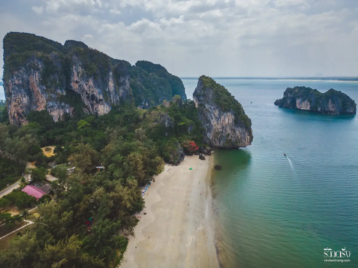
Hat Yao Beach in Trang Province is a long Andaman Sea beach in Ko Libong Subdistrict, Kantang District. The beach is known for its broad sandy shoreline, the striking shark-fin-shaped limestone formation, rows of sea pines, and its quiet coastal atmosphere. It is suitable for walking, relaxing, photography, seaside camping in appropriate areas, and as a practical starting point for boat trips to nearby islands in the Trang Sea.
Hat Yao Beach is located in Mu 6, Ko Libong Subdistrict, Kantang District, Trang Province. Its name reflects the character of the place: a long stretch of sand running along the coast. One end is associated with the distinctive limestone formation often described locally as a shark fin, while the wider coastal route connects with Yong Ling Beach and Chao Mai Beach. This combination of sand, pine trees, limestone cliffs, and open sea gives Hat Yao a landscape that feels different from a typical southern Thai beach.
The main appeal of Hat Yao is its calm, straightforward seaside character. It is not a heavily urbanized resort beach, so visitors come here for a quieter experience: walking along the shore, sitting under the pine trees, photographing the cliffs, watching the sea, or spending time before and after a boat trip. On clear days, the view across the Andaman Sea shows the maritime character of Trang Province, where beaches, fishing communities, limestone islands, and protected marine areas are closely connected.
The beach is broad enough for slow, unhurried visits. A walk along Hat Yao allows travelers to notice the sea-pine line, the texture of the sand, the rocky formations near the end of the beach, and the local coastal life that still shapes this part of Kantang District. Many visitors stop here before boarding a boat or after returning from nearby islands, using the beach as a relaxed pause between land and sea travel.
The shark-fin-shaped limestone formation is one of Hat Yao’s strongest visual landmarks. Rising near the coastline, it creates a memorable natural frame beside the long beach and the open sea. For travelers who enjoy photography, the best compositions are often found near the end of the beach or from angles where the cliff, sand, pine trees, and sea appear together. This is the view that most clearly defines Hat Yao’s identity.
The row of sea pines adds another important layer to the beach atmosphere. These trees provide shade, soften the visual character of the coast, and make the beach more comfortable for short rests during the day. Although some parts of the beach are exposed to strong coastal sunlight, the pine line gives Hat Yao a cooler and more relaxed feeling, especially for travelers who prefer quiet scenery over crowded water activities.
Hat Yao also functions as a gateway to the Trang Sea. The nearby Hat Yao Pier is used for boat travel to Ko Libong and other islands. Because of this, the area is more than a scenic beach; it is part of a working travel route for island trips. Travelers planning to visit Ko Libong, Ko Mook, Emerald Cave, or other marine destinations around Trang can use Hat Yao and its pier area as a convenient starting point for arranging boats and checking local conditions.
Ko Libong is closely linked with Hat Yao. It is one of the major islands of the Trang Sea and is known for its seagrass ecosystem, which supports dugongs. This connection gives Hat Yao ecological importance as well as travel value. A visit to this area is best understood as a combined experience of beach, pier, fishing community, island route, and marine conservation landscape.
Recommended activities at Hat Yao include beach walking, resting under the pine trees, photographing the limestone landmark, watching the sea in the morning or late afternoon, eating seafood near the beach, and arranging boat trips to nearby islands. The beach works well for different travel styles. Visitors seeking quiet can stay on the shore, while those planning island trips can use the area as the first stage of a wider Trang sea itinerary.
Swimming requires care. Parts of the shoreline can have deep water and stronger waves, especially when sea conditions change with the monsoon season. Before entering the water, travelers should observe the weather, wave direction, water conditions, and local advice. For boat trips, snorkeling, or island hopping, it is best to choose operators who clearly explain the route, timing, safety equipment, and weather-related conditions.
The most comfortable times to visit Hat Yao are early morning and late afternoon. Morning is suitable for walking and photographing the sea-pine line before the heat builds up. Late afternoon is better for sitting by the beach, enjoying the sea breeze, and watching the light soften over the coast. Travelers who plan to take a boat should arrive earlier in the day so they have enough time to confirm the route, adjust plans to the weather, and avoid rushing.
There are private accommodations, local restaurants, seafood places, and cafés around Hat Yao and the pier area. This makes the beach useful both as a short stop and as an overnight base. Food in the area is generally connected to coastal ingredients and southern Thai flavors, with several simple, open-air restaurants serving seafood and local dishes. The atmosphere is informal and practical for visitors arriving from the beach or returning from a boat trip.
For trip planning, Hat Yao is best treated as a coastal gateway on the Kantang side of Trang. It connects naturally with Yong Ling Beach, Chao Mai Beach, Chao Mai Cave, Hat Yao Pier, and boat routes to Ko Libong. A practical half-day or one-day route can begin in Trang town, continue toward Kantang District, stop at Hat Yao for the shark-fin cliff and beach scenery, include a seafood meal, and continue to nearby coastal or island destinations depending on weather and available transport.
The tide also changes the experience of Hat Yao. At low tide, the beach appears broader and some rocky details become more visible. At higher tide, the sea comes closer to the pine line and the shore takes on a more open coastal character. Travelers who care about photography should allow time to see how the beach changes with light and water level.
Because Hat Yao is both a natural beach and a community-linked coastal area, visitors should keep the beach clean, avoid damaging the shoreline, respect local fishing activity, and use boat or food services responsibly. Responsible travel helps local people benefit from tourism while preserving the beach, pine line, and coastal ecosystem for future visitors.
Hat Yao suits many types of travelers. Families can come for a quiet beach stop, friends can visit for photos and seafood, couples can enjoy a calm seaside atmosphere, and nature-focused visitors can use the area as a gateway to the seagrass and island ecosystems of Trang. Its strength is simplicity: sand, sea, limestone, pine trees, and local coastal life combine into one of Kantang District’s most useful and memorable seaside stops.
Getting There from Trang town is straightforward by road via Kantang District, using the same general route toward Yong Ling Beach and Chao Mai Beach. Hat Yao is about 47 km from Trang town. Travelers without a private car can take the Trang–Hat Yao public van service from Tha Klang Road in Mueang Trang District, then continue to the beach or Hat Yao Pier according to their itinerary.
A good Hat Yao plan depends on the purpose of the visit. For a simple beach stop, 1–2 hours is enough for walking, photography, and a meal. For boat travel to Ko Libong or other islands, travelers should allow most of the day, check the weather before departure, and contact local boat operators in advance during long holidays. Sea travel in Trang depends on wind, waves, seasonal closures, and local safety decisions.
In summary, Hat Yao Beach combines a long sandy shore, sea pines, a shark-fin-shaped limestone landmark, local coastal life, and access to island routes in the Trang Sea. It is a strong choice for travelers who want a quieter Andaman beach and a practical starting point for exploring Ko Libong and nearby marine attractions.
| Name | Hat Yao Beach |
| Location | Mu 6, Ko Libong Subdistrict, Kantang District, Trang Province 92110, Thailand |
| Address | Ko Libong Subdistrict, Kantang District, Trang Province 92110, Thailand |
| Coordinates | Hat Yao Pier Area: Approximately 7.31065, 99.40146 |
| Highlights | Long sandy beach, sea-pine line, shark-fin-shaped limestone landmark, and boat access to nearby Trang Sea islands |
| Distinctive Features | Broad shoreline, quiet coastal atmosphere, beach walking, photography, suitable camping areas, and convenient pier access |
| Name Origin | The name reflects the long stretch of beach running along the coastline |
| Travel Information | Accessible by road from Trang town via Kantang District, using the same general route as Yong Ling Beach and Chao Mai Beach. Public Trang–Hat Yao vans are available from Tha Klang Road in Mueang Trang District. |
| Current Status | Open to visitors as a beach area and coastal transport point in Kantang District |
| Open Days | Daily |
| Opening Hours | 24 Hours |
| Fees | No admission fee for the general beach area. Boat trips and marine activities are charged by local service providers. |
| Facilities | Private accommodations, nearby restaurants, Hat Yao Pier, boat access, and beachside resting areas |
| Main Areas / Zones | Long beach area, sea-pine line, shark-fin limestone formation, Hat Yao Pier, and boat service points to nearby islands |
| Local Administrative Body | Ko Libong Subdistrict Administrative Organization, with the coastal area connected to the wider Hat Chao Mai National Park context |
| Local Administrative Contact | Ko Libong Subdistrict Administrative Organization, Tel. 0-7529-0965 |
| Nearby Tourist Attractions | 1. Hat Yao Pier, about 1 km 2. Chao Mai Cave And Chao Khun Cave, about 2 km 3. Yong Ling Beach, about 4 km 4. Chao Mai Beach, about 5 km 5. Ao Po, about 5 km 6. Ko Libong, about 8 km by boat |
| Nearby Restaurants | 1. Hat Yao Seafood, about 1 km, Tel. 098-267-0936 2. GongGang Cafe Hat Yao Seafood, about 1 km 3. Chang Kab Rim Lae, about 1 km 4. Hat Yao Seaview & Cafe, about 1 km 5. Krua Ton Toei Hat Yao, about 1 km 6. Yai Cheay Seafood Kantang, about 24 km, Tel. 087-620-4452 |
| Nearby Accommodations | 1. Hat Yao Seaview Beach Room, about 1 km, Tel. 063-163-6383 2. Baan Chao Mai Beach House, about 1 km, Tel. 099-312-8181 3. Hat Yao Nature Resort, about 1 km 4. Sinchai Resort, about 1 km 5. Kruetontoey Guest House, about 1 km 6. Koh Mook Sivalai Beach Resort, about 14 km by boat, Tel. 088-765-0991 |
Frequently Asked Questions (FAQ)
Q: Where is Hat Yao Beach in Trang located?
A: Hat Yao Beach is located in Mu 6, Ko Libong Subdistrict, Kantang District, Trang Province. It is a coastal beach connected with the travel route to Yong Ling Beach, Chao Mai Beach, and Hat Yao Pier.
Q: What days and times is Hat Yao Beach open?
A: Hat Yao Beach is open daily for 24 hours. The most comfortable times to visit are early morning and late afternoon.
Q: Is there an admission fee for Hat Yao Beach?
A: There is no admission fee for the general beach area. Boat trips, island tours, and other private services are charged separately by local providers.
Q: What can travelers do at Hat Yao Beach?
A: Travelers can walk along the beach, relax under the sea pines, photograph the shark-fin-shaped limestone landmark, enjoy seafood, and arrange boat trips to nearby islands.
Q: How do travelers get from Trang town to Hat Yao Beach?
A: Travelers can drive from Trang town via Kantang District, following the route toward Yong Ling Beach and Chao Mai Beach. Public Trang–Hat Yao vans are also available from Tha Klang Road in Mueang Trang District.
Q: Can travelers take a boat from Hat Yao to nearby islands?
A: Yes. Travelers can arrange boats from Hat Yao and Hat Yao Pier to Ko Libong and nearby Trang Sea islands. Weather and sea conditions should be checked before departure.
Q: Is swimming safe at Hat Yao Beach?
A: Swimming is suitable only when the sea is calm. Some parts of the beach can have deep water and stronger waves, so travelers should observe local conditions before entering the water.
Q: Are there restaurants and accommodations near Hat Yao Beach?
A: Yes. There are private accommodations, seafood restaurants, cafés, and local food options around Hat Yao Beach and Hat Yao Pier, making the area suitable for both short visits and overnight stays.
 Category: ●Nature and Wildlife
 Group: ●Bays and Beaches
Last Update : 2 MonthAgo
 Last Update : 2 MonthAgo
 Click to Access the Navigation Map GPS
Hat Yao Beach Map
Recommend

 Art, Culture and Heritage
 Historical Sites and Monuments(1)
 Landmarks and Memorials(2)
 Art, Craft Centres, Tradition(3)
 Museums(2)
 University
 Public university(3)
 Rajamangala University of Technology(1)
 Places of Worship
 Temple(15)
 Mosque(1)
 Other Sacred Sites(7)
 Research and Development
 Royal Project(1)
 Suburban Living
 Village, Community(5)
 National Parks and Marine Reserves(6)
 Mountain (Doi)(8)
 Dam, Reservoir, Lake(1)
 Waterfalls(20)
 Hot Springs(1)
 Caves(11)
Bays and Beaches(11)
 Islands(12)
 Other natural attractions(3)
 Entertainment and Agricultural
 Farms, Parks and Ecotourism(8)
 Outdoor and Adventure Activities(1)
 Shopping
 Department Store(2)
 Travel Articles, Recipes
 Travel Review, Food Review(1)
 Southern Food Menu, Southern Food Recipes(1)


