
lovethailand home >South Travel Attractions >Trang Travel Attractions >Palian >Palian > Ton Tok Waterfall
TL;DR: Ton Tok Waterfall is located at Palian Subdistrict, Palian District, Trang Province 92180, open Open According To Khao Banthat Wildlife Sanctuary Announcements, hours Daytime Access As Permitted By On-Site Officers.

Ton Tok Waterfall
Open Days: Open According To Khao Banthat Wildlife Sanctuary Announcements
Opening Hours: Daytime Access As Permitted By On-Site Officers
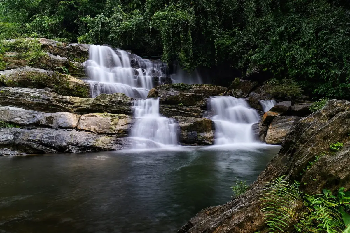
Ton Tok Waterfall in Trang Province is a natural waterfall in Palian Subdistrict, Palian District. It is part of the important waterfall landscape along the Banthat Mountain Range and is located close to Ton Te Waterfall, one of Trang’s best-known waterfalls. Ton Tok Waterfall is distinguished by streams flowing over layered rocks and natural boulders, creating a striking pattern of white water across stone surfaces. During the rainy season, the stronger flow makes the waterfall especially beautiful, with bright white water standing out against the darker rock and surrounding forest.
Ton Tok Waterfall has a different character from Ton Te Waterfall. While Ton Te is known for a larger and higher fall, Ton Tok is appreciated for the way water moves over sloping rock, ledges, and boulder formations. Some sections flow broadly over smooth rock surfaces, while others split into smaller channels before gathering into the stream below. This makes Ton Tok a suitable place for travelers who enjoy detailed natural scenery, streamside relaxation, photography, and a quieter waterfall atmosphere.
The waterfall is located in Palian Subdistrict, an area where plains, foothills, streams, and the Banthat Mountain Range meet. This landscape gives Palian several waterfalls, including Ton Te Waterfall, Ton Tok Waterfall, Nam Phan Waterfall, Nan Sato Waterfall, and Ton Lam Plok Waterfall. Together, these sites show the richness of the forest and watershed system on the western side of the Banthat Range.
Ton Tok Waterfall is connected with Ban Khuan Mai Dam, Moo 2, Palian Subdistrict, Palian District, Trang Province. It is within the responsibility area of Ton Te Forest Protection Unit under Khao Banthat Wildlife Sanctuary. Visitors should treat the site as a protected natural area rather than a general commercial tourist attraction. Following officer guidance, staying within safe areas, and keeping the stream clean are essential parts of visiting the waterfall responsibly.
The waterfall is described as a single-tier cascade where water flows over a steeply sloping rock surface into the lower area. The stream and natural pool are known for their scenic character. The visual appeal comes from granite mixed with limestone; over time, flowing water has eroded the rock and created distinctive textures and patterns. This gives the waterfall a more layered and textured appearance than a simple vertical drop.
The rainy season is the most visually impressive period for Ton Tok Waterfall. Water volume increases, the flow becomes stronger, and the cascade appears as white lines running over rock. The sound of water becomes fuller, the forest feels fresher, and the overall landscape becomes more dramatic. This season is good for photography and waterfall viewing, but visitors must be more careful because of slippery rocks, stronger current, and the possibility of sudden mountain runoff.
From Ton Tok Waterfall, visitors can see Ton Te Waterfall from some viewpoints, especially during the rainy season when Ton Te’s high white stream is more visible. Because the two waterfalls are close to each other, they can be visited together in one route. Travelers may stop at Ton Tok first to enjoy the layered rock stream, then continue to Ton Te to see a larger waterfall flowing down from the Banthat Range.
The route is suitable for travelers who prefer a nature-focused outing without adding too many stops in one day. Ton Tok Waterfall is on the same route as Ton Te Waterfall and is reached first on the right-hand side. This makes it practical to visit Ton Tok before continuing to Ton Te, or to focus on Ton Tok for a quieter experience with more emphasis on boulders, stream textures, and natural rock formations.
The word “ton” is commonly used in southern Thailand for a waterfall or water dropping from a higher level. The word “tok” also means to fall. The name Ton Tok therefore directly reflects the natural character of water descending over the rock landscape.
Ton Tok Waterfall works well as a half-day or full-day trip. A half-day visit can focus on streamside relaxation, careful swimming, photography, and enjoying the forest atmosphere. A full-day itinerary can combine Ton Tok with Ton Te Waterfall, Nan Sato Waterfall, Nam Phan Waterfall, or other Palian nature routes, depending on weather, water level, and available time.
Swimming should be done only in safe areas. Visitors should avoid strong currents, wet rock edges, and climbing over slippery boulders. During heavy rain or after continuous rainfall, the water level and current can change quickly. Families with children should remain in easy-access areas and adults should supervise children closely at all times.
For photography, Ton Tok Waterfall offers several useful compositions: water flowing over tiered rocks, the lower stream, the contrast between white water and dark stone, textured granite and limestone surfaces, and the seasonal view toward Ton Te Waterfall. Morning light and the period shortly after rain can make the scene especially fresh. However, visitors should choose safe photo spots and avoid standing on slippery rocks for a risky angle.
The atmosphere around the waterfall is strongly southern Thai forest: running water, insects, birds, humid air, and shaded trees. Visitors who take time to sit beside the stream will better understand the value of the watershed forest. The experience is not only about swimming, but also about observing the relationship between forest, water, rocks, and downstream communities.
Ton Tok Waterfall is important as part of Palian’s waterfall landscape. Water from the Banthat Range flows into streams and downstream water systems, including waterways connected with the Palian area. Protecting the upstream forest helps maintain water quantity, water quality, ecological health, and local safety, especially during heavy rain when mountain runoff can increase rapidly.
Travel in the Banthat waterfall area should always consider weather conditions. The area has experienced heavy-rain and mountain-runoff events, and natural-resource authorities can control or temporarily close access when risk increases. Visitors should check official announcements before traveling in the rainy season and avoid stream areas when rain is continuous or the water becomes unusually muddy or forceful.
The best visiting time is from morning to early afternoon. This allows enough time to enter the area, enjoy the waterfall, rest, and return before dark. Late-evening visits are not recommended because natural routes become riskier with low light, wet ground, and changing weather.
Useful items to bring include non-slip sandals or water shoes, quick-dry clothing, a towel, spare clothes, drinking water, insect repellent, waterproof protection for phones, and a personal rubbish bag. Visitors who bring food should choose easy-to-pack items and take all waste back out of the area. Food scraps should never be thrown into the stream or left on rocks.
Responsible behavior is essential at Ton Tok Waterfall. Do not leave rubbish, use soap or shampoo in the stream, catch aquatic animals, pick plants, write on rocks, play loud music, or enter restricted areas. Protecting the site keeps the water cleaner, reduces impact on stream life, and keeps the waterfall pleasant for future visitors.
Ton Tok Waterfall suits families, small groups, nature photographers, waterfall lovers, and travelers who want to experience Trang through forest, streams, and mountains. Families should stay in safer lower areas. Photographers should prioritize stable footing and safe viewpoints. Travelers who want to go deeper into the forest should do so only with local or official guidance.
The closest major companion destination is Ton Te Waterfall, also in Palian Subdistrict. Ton Te is a large waterfall with a source in the Banthat Range and is widely known as one of Trang’s major waterfalls. Visiting both waterfalls in one route helps travelers see the difference between Ton Tok’s layered rock stream and Ton Te’s larger highland cascade.
Nan Sato Waterfall is another natural place in Palian for travelers who want a deeper forest route. Visitors should be careful when entering more remote routes because the Banthat landscape is complex, especially in rainy conditions. Routes can be slippery, and weather can change quickly.
Ton Tok Waterfall can also be connected with nature attractions in nearby Yan Ta Khao, such as Sai Rung Waterfall, Lam Plok Waterfall, and Phrai Sawan Waterfall. However, visitors should plan realistically. A waterfall trip should allow time for driving, changing clothes, resting, and adjusting plans to weather conditions. Visiting 2 or 3 places well is usually better than rushing through too many stops.
Getting There follows the same route as Ton Te Waterfall. Ton Tok Waterfall is reached first and is located on the right-hand side before Ton Te. From Trang city, take the Trang–Phatthalung road for about 17 km to around kilometer 53, then turn right onto the Ban Ka Chong–Ban Hat Lao route, Highway 4124. Continue for about 27 km to the waterfall entrance. The distance from Mueang Trang District is about 45 km, and private car or rental car is the most practical option.
Drivers should check the vehicle, refuel before entering the rural route, and plan to return before dark. Roads near natural areas may be wet or covered with leaves after rain. Driving speed should be reduced on curves and hilly sections. Travelers unfamiliar with the route should use navigation together with local signs and ask local residents if needed.
Overall, Ton Tok Waterfall is an important stop on the Palian nature route. Trang is not only about islands, beaches, caves, and local food; it also has upstream forests, granite-and-limestone waterfalls, cool streams, and the Banthat Mountain landscape. Ton Tok Waterfall is a good choice for travelers who want to see a deeper inland side of Trang and enjoy a forest waterfall with distinctive rock scenery.
The best experience at Ton Tok Waterfall comes from careful planning: choose a safe-weather day, start in the morning, prepare suitable outdoor items, and respect the protected area. Its value lies in the movement of water across layered rock, the shaded forest, the sound of the stream, and its close connection with Ton Te Waterfall. With responsible travel, Ton Tok Waterfall remains one of the natural highlights of Palian District.
| Name | Ton Tok Waterfall |
| Location | Palian Subdistrict, Palian District, Trang Province 92180 |
| Nearby Community Area | Ban Khuan Mai Dam, Moo 2, Palian Subdistrict, Palian District, Trang Province |
| Map Coordinates | 7.28058, 99.88324 |
| Highlights | A single-tier waterfall with water flowing over sloping rock layers and tiered boulders; especially beautiful in the rainy season when the stream appears as bright white water |
| Distinctive Features | Water flows across granite mixed with limestone, creating unusual rock textures, natural pools, and stream scenery suitable for relaxation, careful swimming, and nature photography |
| Protected Area | Khao Banthat Wildlife Sanctuary |
| Caretaker / Coordinator | Khao Banthat Wildlife Sanctuary and Ton Te Forest Protection Unit |
| Local Authority Contact | Palian Subdistrict Administrative Organization, Tel. +66 75 290 639 / Forest And Marine Protection Hotline, Tel. 1362 |
| Travel Information | From Trang city, take the Trang–Phatthalung road for about 17 km to around kilometer 53, turn right onto the Ban Ka Chong–Ban Hat Lao route, Highway 4124, and continue about 27 km to the waterfall entrance. Ton Tok Waterfall is before Ton Te Waterfall on the right-hand side |
| Current Status | Open as a natural attraction within Khao Banthat Wildlife Sanctuary under official safety conditions |
| Open Days | Open according to Khao Banthat Wildlife Sanctuary announcements |
| Opening Hours | Daytime access as permitted by on-site officers |
| Area Fee | An access fee or area service charge is collected for entry into Khao Banthat Wildlife Sanctuary at Ton Tok Waterfall according to local announcements |
| Best Season | Rainy season and the period after rain, when water flow over the rocks is more visible; visitors should choose safe-weather days |
| Main Areas / Zones | Waterfall entrance, lower stream, natural pool, sloping boulder zone, rock cascade viewpoint, seasonal view toward Ton Te Waterfall, and natural area under Ton Te Forest Protection Unit responsibility |
| Nearby Tourist Attractions | 1. Ton Te Waterfall, about 2 km 2. Ton Te Nature Trail, about 2 km 3. Nan Sato Waterfall, about 10 km 4. Khao Chet Yot, about 15 km 5. Nam Phan Waterfall, about 18 km 6. Phrai Sawan Waterfall, about 22 km |
| Nearby Restaurants | 1. Tasneem Halal Food, about 25 km, Tel. +66 80 253 5643 2. Tamle Thong Thung Yao, about 25 km, Tel. +66 83 642 9515 3. Jungle Cafe Thung Yao Market Branch, about 25 km 4. T-Time Cafe’ Palian, about 26 km 5. Ban Suan Na Nin Palian, about 38 km, Tel. +66 61 985 1538 6. Waan Waan Dim Sum, about 45 km, Tel. +66 96 398 2656 |
| Nearby Accommodations | 1. Ban Suan Namtok Nan Sato, about 10 km, Tel. +66 61 707 9194 2. Cupid Hotel, about 25 km, Tel. +66 83 692 6888 3. Trang Oasis Waterpark Hotel, about 30 km, Tel. +66 95 419 5536 4. Pink Inn Resort, about 35 km, Tel. +66 20 937 6460 5. Rimlay Boutique Homestay, about 45 km, Tel. +66 86 904 9157 6. HOP INN Trang, about 60 km, Tel. +66 2 080 2222 |
Frequently Asked Questions (FAQ)
Q: Where Is Ton Tok Waterfall Located?
A: Ton Tok Waterfall is located in Palian Subdistrict, Palian District, Trang Province, near Ton Te Waterfall and within Khao Banthat Wildlife Sanctuary.
Q: When Is The Best Time To Visit Ton Tok Waterfall?
A: The rainy season and the period after rain are the best times for viewing the white water flowing over the rocks, but visitors should travel only when weather and official safety conditions are suitable.
Q: Can Visitors Swim At Ton Tok Waterfall?
A: Yes, but only in safe water areas. Visitors should avoid strong currents, slippery rocks, and heavy-rain conditions.
Q: How Is Ton Tok Waterfall Different From Ton Te Waterfall?
A: Ton Tok is known for water flowing over layered boulders and distinctive rock patterns, while Ton Te is known for a larger waterfall descending from a high cliff of the Banthat Range.
Q: How Do I Get To Ton Tok Waterfall From Trang City?
A: Take the Trang–Phatthalung road for about 17 km to around kilometer 53, turn right onto Highway 4124, the Ban Ka Chong–Ban Hat Lao route, and continue about 27 km. Ton Tok Waterfall is before Ton Te Waterfall on the right-hand side.
Q: Is There An Entrance Fee For Ton Tok Waterfall?
A: An access fee or area service charge is collected for entry into Khao Banthat Wildlife Sanctuary at Ton Tok Waterfall according to local announcements.
Q: Which Agency Oversees Ton Tok Waterfall?
A: Ton Tok Waterfall is within Khao Banthat Wildlife Sanctuary and is under the responsibility area of Ton Te Forest Protection Unit.
Q: What Should Visitors Bring To Ton Tok Waterfall?
A: Visitors should bring non-slip shoes, quick-dry clothing, a towel, spare clothes, drinking water, waterproof protection, insect repellent, and a personal rubbish bag. They should also check weather and official area announcements before traveling.
 Category: ●Nature and Wildlife
 Group: ●Waterfalls
Last Update : 2 MonthAgo
 Last Update : 2 MonthAgo
 Click to Access the Navigation Map GPS
Ton Tok Waterfall Map
Recommend

 Art, Culture and Heritage
 Historical Sites and Monuments(1)
 Landmarks and Memorials(2)
 Art, Craft Centres, Tradition(3)
 Museums(2)
 University
 Public university(3)
 Rajamangala University of Technology(1)
 Places of Worship
 Temple(15)
 Mosque(1)
 Other Sacred Sites(7)
 Research and Development
 Royal Project(1)
 Suburban Living
 Village, Community(5)
 National Parks and Marine Reserves(6)
 Mountain (Doi)(8)
 Dam, Reservoir, Lake(1)
Waterfalls(20)
 Hot Springs(1)
 Caves(11)
 Bays and Beaches(11)
 Islands(12)
 Other natural attractions(3)
 Entertainment and Agricultural
 Farms, Parks and Ecotourism(8)
 Outdoor and Adventure Activities(1)
 Shopping
 Department Store(2)
 Travel Articles, Recipes
 Travel Review, Food Review(1)
 Southern Food Menu, Southern Food Recipes(1)


